

(click to enlarge photos)


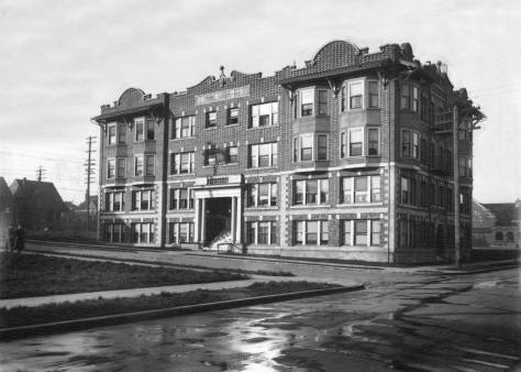
It was a delightful surprise to come – but not stumble –upon this week’s “then.” In the mid-1970s I lived on the second floor of this big box at the southeast corner of Broadway and Republican Street. I shared the space with other instructors and students connected with the nearby Cornish School of the Arts. (Seattle’s by now celebrated empresario Norm Langill [of both One Real and Teatro ZinZanni] had the attic – and the steep stairway to it.)

The featured photo at the top is another of the several 5×7 inch negatives included in a study of billboards and their settings photographed during the years of the Great Depression, from 1929 into the early 1940s. Many of the billboard negatives come with a full day-month-year date, but not our featured photo. For guidance we turned next to the property record cards from the 1937 W.P.A. photo-survey.


The cards show that the narrow vacant lot seen here to the south of our corner lot was developed in 1935 by a jeweler named William Cobb. So our “then” dates from before 1935. (See the right side of t he ca. 1937 tax photo five cards up.) Coming with his own sidewalk clock, Cobb lent some class to the block-long collection of often-typical retailers on this east side of Broadway between Harrison and Republican Streets. The strip included a G.O. Guy Drugs, a Diamond 5c to $1.00 Store, a Brehms Delicatessen, the Yoshihard Laundry, Sam Tanneff’s Shoe Repair, John Jone’s Meats and three greengrocers, including the long-time tenant Queen City Grocery here at 434 Broadway. Whatever their age, there is something fresh about the retailers here, both brick and frame. Between Harrison and Roy Streets they were all – including the big box – dragged east in 1930-31 for the widening and somewhat fussy straightening of Broadway.


This week’s featured “then” was probably photographed soon after the move. Behind the signed windows upstairs are the offices of a chiropractor and the dentist Dr. J. Marvin Brown. A mention about Brown from The Times in 1931 is not an advertisement for painless extractions, but news that he was part of the Reception Committee for a Capitol Club Banquet at Pilgrim Congregational Church, located across Republican Street from his office. The impressive line-up of speakers included the governor, the mayor and the president of the Seattle Chamber of Commerce.
The dentist was probably as well known for his trigger-finger as for his drill. Brown’s hunting and fishing feats often made the news. He appeared on the front cover of the Seattle Sunday Times color rotogravure Pictorial for November 7, 1954. (Check out the Times archive, if you will.) In that precursor of this magazine, Brown cuddles in a still life, with his Springer Spaniel, shotgun and bagged pheasant, beside a rustic barn near the Whitman County village of Hay.

But, of course, at least for the “then” photographer, the intended celebrity here is the billboard for the corn product Karo, a table syrup introduced in 1902 and soon advertised nation-wide as “The Great Spread for Daily Bread.”

WEB EXTRAS
Anything to add, les mecs? Yes Jean, Ron has gathered a sweet collection of relevant features and will attached them below. I’m quitting, however, off to nighty-bears. It’s 5:15am. I’ll add a few more features and bon-bons after my mid-afternoon breakfast later today. And if time encourages me I’ll put up a few of the thousands of Broadway Bus Stop portraits I snapped in 1976-77 from the Kitchen Window on the second floor of our rental-box above Peters on Broadway. I am fond of them.


======
[below] BROADWAY & REPUBLICAN BUS STOP AS SEEN LOOKING WEST ACROSS BROADWAY FROM OUR KITCHEN WINDOW IN 1976-77 (at the the bottom of these few examples pulled from hundred of snaps we have put a link to a past feature that also included a few of these Broadway candors.)


