

(click to enlarge photos)


From his climb to the cornice of the eighteen-story Medical Dental Building, Jean Sherrard has thoughtfully returned with some frosting, one of the building’s crowning terra-cotta ornaments. Peeking at the bottom-right corner of Jean’s repeat, resembling a lampshade, it is one small part of the building’s elegant skin.

First imagined by its mix of professional (physicians and dentists) developers as a “real medical center in Seattle,” the polished and ornate Medical Dental Building was dedicated in 1925. With its ceramic tile cladding and more, the tower would be interpreted as an example of the late Gothic Revival, which, as it turned out, was a style about to lose its popularity.

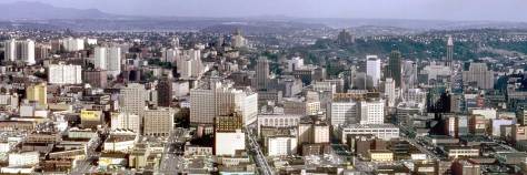
Looking north, from its tower, Westlake Avenue can be followed to Denny Way, where it elbows slightly to the northeast to complete its arterial duty to both Westlake and eventually Eastlake at the south shore of Lake Union. Westlake was sided by the triangular blocks and buildings fashioned in 1906-7 when it was cut through from Pike Street to Denny Way. Its landlords briefly named this new and direct approach to the north “The Big Funnel”.


Jean’s thoughtful inclusion of the decorative ornament encourages us to extend our short review of the architectural history of this retail neighborhood at the north end of Seattle’s central business district. It began in earnest in the early 1880s with a few retailers scattered about the slopes of the by then clear-cut Denny Hill. The businesses were mixed with modest residences – some in rows – and tenements, all made from lumber milled on the shores of Elliott Bay and Lake Union. Aside from the built-for-show blocks around Pioneer Square and on Front Street (First Avenue N.) the fancier construction of this metropolis began only after its cinder-scrubbing by the Great Fire of 1889. Seattle began then to earnestly boom and build, often with bricks and the encouragement of better insurance rates for those who embraced both the new ordnances and bricks.

As for grace and style, terra-cotta tiles became nearly a necessity for any proud developer in the new twentieth century, until the expense of it became forbidding in the thirties with the Great Depression and/or too fussy for the more functional modernist tastes. One sizeable resister to modernity, “the Old Quarter,” appears here in the featured photo on left of Westlake and to this side of Denny Park’s greenbelt, also on the left. This is the last of the Denny Hill neighborhood. In 1911 it was left to molder when the Denny Hill Regrade reached Fifth Avenue and stopped. It remained dormant until 1929 when everything in this triangle was razed, including the low rents, just in time for the Great Depression.


WEB EXTRAS
Anything to add, boyos? Sure Jean and by now we know the march. Ron Edge and I put up a sturdy parade of part features that relate to the week’s primary subject or concern or thereabouts. (Here I had hoped to include the original latin for “Repetition if the Mother of All Learning” but my computer has lost my “Google Translate” capacities. For the moment.)


=====

=====

=====

click to enlarge
=====

=====

=====

=====

====

====

=====

=====

=====