

(click to enlarge photos)


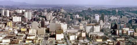
I came upon this week’s revealing pair of historical photos in the mid-1970’s during my initial visit to the Seattle Engineering Department’s photo-lab at City Hall. Both were given curt captions at their bottom-left corners, identifying this public work as Denny Hill No.2 Regrade. The diptych reveals with “before” and “after” panoramas the final humbling of Denny Hill between 1928 and 1931. (Last week’s feature gave another point of view on that last regrade.) The digging for Denny Hill Regrade No. 1 began in 1903. In 1911 the cutting paused for seventeen years before resuming in 1928 with Denny Hill Regrade No. 2. By pulling a lever, Seattle Mayor Frank E. Edwards scooped the last electric shovelful in the forenoon of December 9, 1930. Both the 1928 and 1931 pans include the south facade of the Windham Apartments at the northwest corner of Fifth Ave. and Blanchard Street. With its 1925 brick facade intact, the Windham still serves but is now, from the Claremont’s roof, for the most part hidden behind the chisel-shaped glass curtain at the southwest corner of Fifth and Blanchard.
WEB EXTRAS
Thanks to Hotel Andra (nee Claremont) for hosting our trip to their rooftop. Also, big thanks to Brian Cunningham, Chief Engineer, for his assistance on high.

He related a Hotel Andra secret, which can only now be revealed! If you examine the photo below, note the twin architectural details high above the hotel’s Fourth Avenue entrance. The grenade-shaped protuberances at the top of each feature seem to be intact…but, no! The one on the right went missing at least a decade ago.

Brian discovered that a Nerf football, scribed to approximate the lines of the original, painted gray and glued into place would suffice, certainly from a distance. I think it looks pretty fine close up as well (click to enlarge to see for yourself).


Finally, a shot of the Space Needle from the rooftop:

Anything to add, lads?
Yes Jean, but first thanks for the roof architecture atop the old Claremont. I too love “Hulot’s Holiday” and saw it first at the Harvard Exit in the early 1970s. But you have me puzzled how that trip from Paris for a holiday on the Normandy Coast (I assume) with a stay in a waterfront hotel filled with eccentric guests relates to your textured reflection of the Needle off Garth Vader’s glass skin. Will you explicate, please?
Yes, Paul, my mistake – I meant to say ‘Playtime’ – the 1967 film which featured Monsieur Hulot wandering through glass and steel skyscrapers, unable to find the Eiffel Tower or the Arch de Triomphe, except in the glass reflections. A marvel of the cinema (which, was unappreciated at the time, and bankrupted Hulot creator Jacques Tati).
Second, we hope our dear readers will key word our blog for “Denny Regrade” or any other key. For instance, our Illustrated History of the Seattle Waterfront (found here under the “books bug”) has a thumbnail history of the Denny Regrade.


=====
MY FIRST INTIMATE GLIMPSE OF THE PRE-REGRADE DENNY HILL NEIGHBORHOOD. The text here is copied from Seattle Now and Then Volume One, the Fifty-Second story. An earlier version was first printed in The Seattle Sun. It was that tabloid exposure that, I believe, persuaded The Seattle Times to take me on as a suffering free-lance contributor in the winter of 1981-82. I discovered the historical photo, which looks south on Second Avenue from its intersection with Bell Street, in a stack of prints that John Hannawalt – still of the Seattle Paperworks in the Pike Place Market (lower level)- purchased from Loomis Miller, the last keeper of the Webster and Stevens Studio. It was an exciting moment for me. I had by then plenty of exposure to regrade pictures, and distant portraits of Denny Hill long before the lowering began, but none of the intimate neighborhood. They are still rare. One of the best was featured recently in “Too High and Too Steep”, David B. Williams historical study of the several natural upheavals that have come with making Seattle. Our review of David’s well-illustrated study of the “reshaping of Seattle topography” is included here below illustrated with the Anson Burwell House at Denny Hill’s high point the intersection of Fourth Avenue and Blanchard Street. You will find it below, second from the top with the Edge Clippings,


Second Ave. is on the left. (Courtesy, Michael Maslan)


=====
THE EDGE CLIPPINGS


=====

=====

=====

=====

=====

=====

=====

=====

=====
=====

=====

=====
