Seattle Now & Then: Denny’s Swale

(click to enlarge photos)

THEN: We imagine that the photographer A.J. McDonald waited for one of his subjects, the cable car to Queen Anne Hill, to reach the intersection of Second Ave. N. and Aloha Street below him before snapping this panorama in the mid-1890s.
NOW: Jean Sherrard chose the revealing upper west-bound half of Ward Street to record his ‘repeat’ south into the Seattle Center.

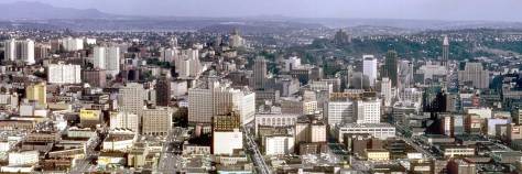
For reasons that may in part have had something to do with nostalgia for farm life and open mid-western pastures, the young city builders David and Louisa Denny protected from development most of the swale, or naturally cleared wetland, on their pioneer claim.  Much of that clearing is included in this look south from the still lightly developed southern slope of Queen Anne Hill, in the foreground, to the extensive scatter of structures on Denny Hill, crowned by its landmark Denny Hotel, at the middle distance.  The far horizon extends from West Seattle, on the right, along the ridge of Beacon Hill to First Hill, the ‘Profanity Hill’ part of it, where the brandishing tower of the King County Court House makes a perpetual promotion for law and order.

A closer look to the rear of the Denny (AKA Washington) Hotel, this shot early by the NPRR photographer Hayes on visit to Seattle ca. 1890 or 1891. The shot looks south on Third Avenue from north of Virginia Street. (Courtesy, Montana Historical Society)
A closer look to the rear of the Denny (AKA Washington) Hotel, this was recorded by the NPRR photographer F. J. Hayes on a visit to Seattle ca. 1890 or 1891. The shot looks south on Third Avenue from Lenora  Street. (Courtesy, Montana Historical Society)
The same hotel - Denny or Washington - looking northwest form Fourth Avenue between Pine and Steward Streets. Stewart is on the right. (Courtesy of Louise Lovely, is what we called in the early One Reel Vaudeville days when Louise performed at fairs and festivals from the rear of a truck rigged with a stage. )
The same hotel – Denny or Washington – looking northwest from Fourth Avenue between Pine and Steward Streets. Stewart is on the right. (Courtesy of Louise Lovely.  That  is what we called Louise in the early One Reel Vaudeville days when she performed at fairs and festivals from the rear of a truck rigged with a stage. )

This week’s ‘then’ is one of a dozen or more panoramas that the photographer A. J. McDonald took of Seattle from a few of its hills during his, it seems, brief stay in the early mid-1890s.  (We will attached a few more below.)  This is one of the more softly focused of the photographer’s recordings, but it is still outstanding.  No doubt, McDonald is standing with his tri-pod on or near Ward Street and sighting south on Second Ave. N.  It is about 1895, the year the Seattle Dept. of Public Works regularized and thereby restrained the often imaginative collection of Seattle’s street names. 

A detail of the South Queen Anne neighborhood from the 1893 Sanborn Real Estate Map, before the regularizing of the street names. Notice there are two Thomas Streets showing here.
A detail of the South Queen Anne neighborhood from the 1893 Sanborn Real Estate Map, before the regularizing of the street names. By way of example, notice there are two Thomas Streets showing here.  A portion of Harrison is named Fourth, and Queen Ane Ave. is still Temperance Ave, which with Republican Street  heralds the political devotions of David and Louisa Denny who set their migrant’s claim here.  [Click to Enlarge]

Previously, Second Ave. N. was Poplar Avenue, and Ward was Villard Street. The last was named for the journalist-capitalist who brought the Northern Pacific Railroad to Seattle in the early 1880s and then promptly lost it. 

Running left-right (east-west) above the center of the pan is Harrison Street, which now passes through the fanciful clutter of the irregularly-shaped Seattle Center.  Nob Hill Avenue, which was Ash Avenue until 1895, reaches Harrison directly above the center of McDonald’s panorama.  Directly below that intersection is the swale, still holding on to its green, but now transformed into part of the artificial grass end zone of the Seattle Memorial Stadium.  [There is a good now-then comparison of the swale among the Edge Links that follow this brief exposition.]

The swale hosting a circus. The view looks north from near Harrison Street. Nob Hill Ave. is on the right.

The list of historical uses of this clearing begins with the Duwamish Tribe’s both ritual and practical potlatch celebrations, and their catching in nets the low-flying waterfowl passing between Elliott Bay and the then restful tulles at the south end of Lake Union.  With the Dennys in the early 1850s came their extensive gardens, which helped feed both their family and Seattle’s produce needs. In the late 1890s the swale was fitted with an army corral filled with horses and mules for help with the Spanish-American War.  Soon after McDonald’s visit, the swale repeatedly hosted other horses, with carnivals and traveling circuses.  Part of it was also developed into a fenced field with bleachers for professional baseball.  In 1927-28 the swale was appointed with the concrete core for Seattle’s arts and entertainment culture: the Civic Auditorium, Arena, and Civic Field.

Construction on Civic Field, the Civic Auditorium and Ice Arena in the late 1920s. The aerial looks northeast over Lake Union and it's clutter of salvaged ships.
Construction on Civic Field, the Civic Auditorium and Ice Arena in the late 1920s. The aerial looks northeast over Lake Union and it’s clutter of abiding ships waiting for sale, use, salvage  or perhaps to be cleaned in fresh water..

In 1958, or thirty years later, the Seattle City Council allotted $7,550 for the clearing away of eighteen “dilapidated buildings” from the by then probable site of the Century 21 Exposition, Seattle World’s Fair. It is likely the McDonald’s panorama includes some of the condemned structures in the neighborhood beyond Harrison Street, on the far side of the swale.

A copy of most of the
A copy of most of Ordinance No. 86033 “providing for the condemnation of property as a site for civic center development.  This is sent compliments of Scott Cline, the city’s archivist who is about to retire after thirty-plus years of organizing the municipal archive with considerable success and consistent skill.  Regarding this ordinance, the retiring archivist notes “I’ve included the portion of the ordinance that lists all of the property subject to condemnation.  It is listed by legal description (addition, block, and lot).  The rest of the ordinance (on a different page) is boiler plate with a section that notes the costs will be paid through the Seattle Civic Center Development Bonds 1956 Fund.  The ordinance was passed by Council on April 8,1957 and signed by Mayor Clinton on April 9. ”  Thanks Scott, and may your plans for a retirement of writing, exercise  and travel follow.  We will add that on June 26, 1958 the Seattle Times reported that “Fred B. McCoy, City Building Superintendent, asked City Council to appropriate $7, 550 to raze 18 dilapidated  buildings in the Civic Center area.”

WEB EXTRAS

Anything to add, kids?  Sure Randall.  Ron has topped his past clips from the neighborhood with another by McDonald panaorama, one that looks northwest from Terry Avenue and Union Street towards Lake Union with the northeast corner of Queen Anne Hill on the far right.   But first we will “trump” Ron by showing a merge he composed of two other McDonald pans that were, like the featured photo, taken from a prospect on or very near Ward Street and looking east over Fifth Avenue.   That double pan follows now.  Please double click it.

Two McDonald pans from Queen Anne Hill with a sweeping Capitol Hill horizon have been merged by Ron Edge
Two McDonald pans from Queen Anne Hill with a sweeping Capitol Hill horizon have been merged by Ron Edge.  The home on the far left is at or near the southeast corner of Ward Street and Fifth Avenue.  Please Double Click.

THEN: A.J. McDonald’s panorama of Lake Union and its surrounds dates from the early 1890s. It was taken from First Hill, looking north from near the intersection of Terry Avenue and Union Street. (Courtesy, Museum of History and Industry)

THEN: In the first years of the twentieth century, visiting circuses most often used these future Seattle Center acres to raise their big tops. After 1911 the favored circus site was moved to the then freshly-cleared Denny Regrade neighborhood (Courtesy, Mike Cirelli)

THEN: Looking west from the southwest corner of 6th Ave. N. and Mercer St. to the trolley barn and yards for the (renamed in 1919) Seattle Municipal Railway in 1936. (Courtesy Lawton Gowey)

THEN: An early-20th-century scene during the Second Avenue Regrade looks east into its intersection with Virginia Avenue. A home is being moved from harm's way, but the hotel on the hill behind it would not survive the regrade's spoiling. Courtesy of Ron Edge.

THEN: In 1910, a circa date for this look north on First Avenue across Virginia Street, the two corners on the east side of the intersection were still undeveloped – except for signs. The Terminal Sales Building, seen far right in Jean Sherrard’s repeat, did not replace the billboards that crowd the sidewalk in the “then” until 1923. (Seattle Municipal Archive)

https://i0.wp.com/pauldorpat.com/wp-content/uploads/2013/05/crockett-7-w-row-then-mr1.jpg?resize=474%2C308&ssl=1

THEN: The home at bottom right looks across Madison Street (out of frame) to Central School. The cleared intersection of Spring Street and Seventh Avenue shows on the right.

pacific-snow-then-web

THEN: The Dog House at 714 Denny Way was strategically placed at the southern terminus for the Aurora Speedway when it was new in the mid-1930s. (Photo courtesy of Washington State Archive, Bellevue Community College Branch.)

THEN: Long thought to be an early footprint for West Seattle’s Admiral Theatre, this charming brick corner was actually far away on another Seattle Hill. Courtesy, Southwest Seattle Historical Society.

THEN: Looking south from Pine Street down the wide Second Avenue in 1911, then Seattle’s growing retail strip and parade promenade. (courtesy of Jim Westall)

THEN: While visiting Seattle for some promoting, silent film star Wallace Reid shares the sidewalk at 4th and Olive with a borrowed Stutz Bearcat. (Courtesy, Museum of History & Industry)

THEN: Before this the first shovel of the last of Denny Hill was ceremonially dropped to the conveyor belt at Battery Street, an “initial bite of 30,000 cubic yards of material” was carved from the cliff along the east side of 5th Avenue to make room for both the steam shovel and several moveable belts that extended like fingers across the hill. It was here that they met the elevated and fixed last leg of the conveyor system that ran west on Battery Street to the waterfront. (Courtesy, Seattle Municipal Archive)

2nd-and-Blanchard-THEN

THEN: Thanks again and again to Lawton Gowey for another contribution to this feature, this ca. 1917 look into a fresh Denny Regrade and nearly new “office-factory” at 1921 Fifth Avenue. (Courtesy, Lawton Gowey.)

THEN: The Seattle Central Business District in 1962. I found this panorama mixed in with the Kodachrome slides photographed by Lawton Gowey. It was most likely taken by my helpful friend Lawton, who died in 1983, or Robert Bradley, Lawton’s friend in the then active Seattle Camera Club. (Courtesy, Lawton Gowey)

======

The SARAH B. YESLER HOME (for working girls), AKA the NEW WAYSIDE EMERGENCY HOSPITAL, AKA the CLINTON APARTMENTS, AKA the CLARION APARTMENT HOUSE, all of them at the northwest corner of Republican Street and Second Avenue North, and found in the shadows on the far right of the featured photo at the top, and also below.

First appeared in Pacific on Sept. 30, 2001.
In its last incarnation as the Clarion Apartments. This is another neighborhood photo taken by Lawton Gowey who lived up the hill for his entire life.

=====

ANOTHER MCDONALD PAN – This from DENNY HILL to CAPITOL HILL with the Cascade Neighborhood in between.

clip,-McDonald-to-Cap-web-

clip-davidson-Denny-Hill-to-

=====

THE BAGLEY MANSION, Northeast Corner of Aloha and Second Ave. N.

Clarence Bagley published the now classic three-volume history of Seattle in 1916. He worked administering the city's public works department.
Clarence Bagley published the now classic three-volume history of Seattle in 1916. He worked administering the city’s public works department.
From The Seattle Times for December 27, 1925. [CLICK-CLICK to ENLARGE]
From the Times Dec. 7, 1933.
From the Times, Jan. 16, 1944.


This McDonald pan was taken from within a low shouting distance of the Ward (Villiard) Street pan featured at the top. That pan just missed including a corner of the Bagley mansion at the northeast corner of Second Ave and Aloha Street, bottom-right. Mercer School is found just above and beyond it. Again the horizon is held by Capitol Hill. (Courtesy, Museum of History and Industry.)
This McDonald pan was taken from within a short shouting distance of the
Ward (Villiard) Street pan featured at the top. That pan just missed including a corner of the Bagley mansion at the northeast corner of Second Ave and Aloha Street, bottom-right. Here, Mercer School is found just above and beyond it. Again the horizon is held by Capitol Hill. (Courtesy, Museum of History and Industry.)

One thought on “Seattle Now & Then: Denny’s Swale”

Leave a Reply

This site uses Akismet to reduce spam. Learn how your comment data is processed.