THEN: This portrait of the Seattle Gas Company’s storage tank dates from the spring of 1907, which explains its somewhat steeper topography. In 1911, both Republican Street, here on the right, and 9th Avenue N. were lowered to a grade close to that of Westlake Avenue, which is behind the photographer.NOW: Building C (2008) of the University of Washington Medicine Research Center at the south end of Lake Union fills the northwest corner of Republican Street and 9th Avenue. Five buildings for the Research Center are completed, with two more planned.
Here we look northwest across the intersection of 9th Avenue N. and Republican Street to the first of two gasholders, or gas storage tanks, that were quickly built in succession on this south Lake Union block. Most likely some of PacificNW’s readers will remember them, for the tanks were still around in the 1950s, until replaced by the Seattle Gas Company’s modern building, which was popularly known as the “Blue Flame Building” after the illuminated sign that crowned it. It, too, is now gone, replaced by a new construction in what we might call “Allentown” for its primary developer Paul Allen, or perhaps “Amazopolis” for the made-over neighborhood’s primary tenant.
The foundation for the first of two tanks, with the Queen Anne Hill horizon, as yet without Queen Anne High School (1909). This snapshot like most of the others in the “Gas Album” is dated. Nearly a half year before the feature photo, this is November 10, 1906.The photographer here stands west of 9th Avenue and on Republican Street. (Like the others from the Gas Album, this is used courtesy of Michael Maslan.)Nearly two weeks later, March 23, 1907Unless I change my mind – or proven wrong – this look south on 8th Avenue from Mercer Street. It is dated April 27, 1907.
The featured photo of the gas tank on top (and above) was copied from an album of views, most of which concerned the big changes made for the Seattle Gas Company between 1906 and 1908. Most of the snapshots feature the destruction of the company’s first plant, built in 1873 at Fifth Avenue and Jackson Street, and the building of its gas works, now Gas Works Park in ‘Lower Wallingford.’ The album was loaned to me for copying by Michael Maslan, one of
A Gas Works (Wallingford peninsula) scene ca. 1971, and so before the park. The chorus is singing “Humpty Dumpty had a Great Fall” accompanied by Butterfat, a rock band from Wyoming. Until this moment of caption writing it had not occurred to me that the chorus many have been singing a precaution – about falling and taking care – to themselves.The Butterfat Chorus can also be found in this photo of the band Butterfat trusting the 65-year old construction of the gas works. They are all “accompanied” to the right by the “Universal Worm.” We also hung one of these worms from the lip of the Space Needle for eventual use (we hope) in the film/video “Sky River Rock Fire.” It, or part of it, may sound familiar to some readers: the survivors. Thanks to Marc Cutler, one among us (although in Bellingham) some of us are wearing gray T-shirts modestly imprinted with the message “Not Dead Yet.”The Gas Works at the north end of Lake Union in 1947 when it was still manufacturing.
Seattle’s busiest sellers of historical photographs and other ephemera. Michael has been sharing his often rare and exquisite ‘stock and stuff’ with me since the mid-1970s, and many of the images that have appeared in this column over the past thirty-three years came to me through Michael.
The above is text for the Gas Album photograph above it. Both appeared first in PacificNW on April 25, 1993. The photograph dates from March 24, 1907. The tanks at this firt site were off-camera and north of Jackson Street, to the left. Courtesy, again, Michael Maslan.
The featured print at the top is dated May 4, 1907. On that Saturday, The Times variously reported that railroad cars of Florida Tomatoes and Bananas had arrived, and that a “heavy shipment of strawberries (had) reached the city this morning.” Preparing, perhaps, its readers for Sunday church, on its front page, The Times explained that two clergyman with “differing schools of theology,” the Unitarian Rev. W.D. Simonds and the Baptist Rev. J. M. Dean, agreed that “men are most iniquitous,” not women. One week later, on May 11, the renamed Seattle Lighting Company ran one of its illustrated advertisements advising, “Cook With Gas and avoid worry and trouble. It is cheaper, healthier and cleaner than any other fuel in use.” This promotion was repeated on the storage tanks with large hanging signs also reading, “Cook with Gas.”
“COOK WITH GAS” signs can be found hanging on both of the Lower Queen Anne tanks in this view from upper Queen Anne aka “The Hill.” Part of the David and Louisa Denny orchard still flourishes to the west (right) of the tanks, and to the right of the fruit trees the family home is still standing on the north side of Republican Street between 8th Ave. and Dexter Street, although the Denny family has long-since move from there. Cascade School, at Pontius and Thomas is seen upper-left. It lent its name to the neighborhood, although no opportunity to see the Cascade Range came with the Seattle School Board’s gift.
It is clear from the photo album that the charming building to the right (in the featured photo and two below it) was built with the storage tank, and somehow served it. The oversized shed – or barn – on the left may be the livery stable for the company’s horses, which by 1907 were beginning to lose their horsepowers to internal combustion. A Times classified for June 30 hints at this dislocation. “Four combination ladies’ or gents’ single foot saddle or driving horses for sale at Seattle Lighting Co.’s stable, Ninth North and Republican. These horses all trot in harness.” (The barn on the left may also be part of the Denny family farm.)
The COOK WITH GAS sign is evident here too. The subject looks northeast across Republican Street in the block between Eighth Ave., on the right, and Dexter, off-camera to the left. The 1911 regrading on Republican is underway, and the Denny family is long-gone from this their home between 1871 and ca. 1890. Note the barn, far-right. It was noted in the main text with some speculation.
WEB EXTRAS
Anything to add, fellahs? Yup. Ron Edge has pulled forth a half-dozen or some former features that touch either the neighborhood or the subject. Please remember that these links are often stuffed with other links, and some of those may also be so stuffed.
=====
The Denny’s big home humiliated some with a one block moved south to the southeast corner of Republican and Queen Anne Avenue, and there suited with apartments.
=====
Looking north on 9th Avenue with the photographer’s back to Denny Way. The regraded cliff to Denny Park’s eastern border is on the left. The Gas Tanks are hidden behind the homes upper-left.First appeared in Pacific, July 20, 2003.
THEN: Looking west from the southwest corner of 6th Ave. N. and Mercer St. to the trolley barn and yards for the (renamed in 1919) Seattle Municipal Railway in 1936. (Courtesy Lawton Gowey)NOW: Because of the 1958 dipping of Mercer Street below Aurora Ave., Jean Sherrard needed his 10-foot extension pole to approach the old elevation of 6th Ave. N. Now he records part of the Bill and Melinda Gates Foundation’s embracing boomerangs, the latest footprints on what was once a Duwamish potlatch meadow.Here’s a look south over Mercer Street (in the ditch) that I took recently and casually. I did not suspect that it would be of use. But lo. There’s 6th Avenue continuing across the way and with a little figuring one can find the place spot – left of center – where Jean stood with his 10-foot pole (and camera) to take his repeat. Also the habitat in which he made the Youtube video below can be found over there as well – on the far right. And upper-right is the new sculpture hanging above the courtyard caressed within the Bill and Melinda Gates Foundation campus. In the coa of the video, Wendy Walker describes the history and qualities of the sculpture, which while grand and kinetic too also reminded me of the hanging nets in Ivar’s old Acres of Clams on Pier 54. pdThe corner of Mercer and 6th marked three times with red dots. The aerial on the left is used courtesy of Google, and the map at the center is a detail from the Baist Real Estate Map for 1912, courtesy Ron Edge. (CLICK to ENLARGE)
I imagine that many Pacific NW readers will remember this parking lot filled with municipal buses. It was not so long ago. However, few are likely to recall the earlier and regular overnight visits here of the city’s orange trolleys, scores of them packed side-by-side on parallel tracks.
One of the municipal trolleys yellow-orange trolleys in 1940, in the last weeks of the systems life. (by Lawton Gowey)
This North Seattle Storage Yard was built in 1906 by the Seattle Electric Company, the transportation “octopus” that by then had consolidated most of the city’s independent trolley lines and also kept on building new ones while Seattle grew like an adolescent. The brick car barn, upper-left, was added in 1907 for trolley repairs. By 1910 the expanding system had yards and barns in Fremont, Georgetown and at 14th Ave. and Jefferson St.
The Jefferson Yard filled with new buses. Photographed for the Seattle Transit System on Dec. 15, 1940.The Seattle Times front page for December 11, 1936. The future Queen Elizabeth has not quite yet learned of her fate, and English labor warns her dad to pump down the pomp.
As the original print reveals at its base, the subject lookling west over the parking yard was photographed on Dec. 11, 1936. The “N.E. Corner,” captioned bottom-right, is at Sixth Ave. N. and Mercer St., which is on the right. The Auditorium Apartments, the dark four-story brick construction at the northwest corner of Fifth and Mercer, is partially hidden behind the power pole on the far right. This apartment house, with two exceptions, is the only notable building (from this prospect) that has survived from the “then” into Jean Sherrard’s “now.” The two exceptions are the Civic Auditorium and its linked neighbor, the Ice Arena. And in 1936, from this point of view, the Civic Auditorium seems to be named the Ice Arena.
Much can be found in this late 1920s aerial looking northeast over the construction site of the Civic Auditorium, Ice Arena and Field. The trolley barn is the dark mass to the right of the brilliant civic center grounds. Mercer Street is the bright way that passes left-right behind the Civic Auditorium. CLICK TO ENLARGEThe Civic Center ca. 1930 from Queen Anne Hill. The trolley yard is out of frame to the left. (Courtesy, Washington State Museum, Tacoma)An early auto show inside the Civic Auditorium.
However, the sign to the left of the stubby power pole in the featured photo at the top, is not posted on the Civic Auditorium, but rather stands on the roof of the auditorium’s attached neighbor to its east, the Ice Arena.
You (not I) may judge the date for this look across Mercer Street at Civic Ice Arena by the rolling stock. The walking stock seems to be both leaving the arena and standing in line to get in. My dad used to regularly take me to the Ice Capades in Spokane. I liked the clowns.Public skating at the civic rink photographed for the Post-Intelligencer and used courtesy of the Museum of History and Industry.Some of the public skaters got special attention in fitting their equipment. {Overheard, “Will you please tie my skates?”) Another pix from MOHAI’s P-I collection.
The 1927 auditorium has gone through two elaborate make-overs: first as the Opera House for the 1962 Century 21 Worlds Fair and again in 2003 as McCaw Hall.
This is not our 1962 Opera House redo of the 1927 Civic Auditorium but the Opera House in Paris during my visit there as a teenager in 1955. It has been cleaned since then. We make this substitution to expresses our thanks and love for Berangere Lomont, the third person with hands on this blog, and Paris too, her home.McCaw Hall with its Kreielsheimer court when nearly new in 2003.
On this Friday night of Oct. 11, 1936, the Ice Arena was booked for the first night of two with the Nile Temple Shriners Ice Carnival, which mixed “the pick of Seattle’s skating talent,” which included Shriners in their “vivid costumes, freak acts and comedy performances,” sharing the ice with “some of the finest exhibition skaters in the world.” This was also the season when the Ice Arena’s offerings switched from the faked, if often bruising, melodrama of professional wresting to ice, with the city’s well-outfitted amateur skaters and a professional hockey club. Devoted Seattle sports fans will know that the professionals then were also called the Seattle Seahawks.
The Seahawks, Jack Dempsey, and much else on the Seattle Times sports page for November 12, 1933.
WEB EXTRAS
Anything to add, Paul?
Aside from what is inserted in the text “proper” above, Ron and I have chosen a few more features either from the neighborhood or the subject and attached them below.
=====
=====
Seattle Municipal Railway’s first yard of its own. First appeared in Pacific August 1, 1999.
=====
First appeared in Pacific, November 14, 1993.
=====
THREE MORE FROM THE NEIGHBORHOOD IN THE 1930s
First appeared in Pacific, May 18, 2003.Looking north on Aurora ca. 1933 thru its stop-lighted intersections with Broad and Mercer, together the busiest crossroads in Seattle and most dangerous. Both Broad and Mercer were tunneled under Aurora in the 1950s.A depression-time remodel by the state’s Emergency Relief Association (E.R.A.). Dated Nov. 18, 1934, the last time I looked the bungalow at 364 Roy Street was still there, part of a restaurant. (Courtesy, Washington State Archive)
======
The west facade of the North Seattle yard near or during the end of the 1917 trolley strike. The workers – we assume – are standing on Fifth Avenue. The structures to the left of the garage are on the north side of Mercer Street. (Courtesy, the Museum of History and Industry)
======
WATERFALL AND WATERFOWL
An exhibit in the Forestry Building for the AYPE of 1909 on the UW Campus.
======
The North Seattle Storage Yard at 5th and Mercer during the Big Snow of 1916. First appeared in Pacific April 14, 1991.
THEN: The city’s north end skyline in 1923 looking northwest from the roof of the then new Cambridge Apartments at 9th Avenue and Union Street. (Courtesy, Museum of History and Industry)NOW: Although somewhat wider than the historical photograph, Jean Sherrard’s repeat includes a fraction of the ambitious ascension of north end skyscrapers competing for variety in their facades.
This, I believe, is only the second occasion in which Jean Sherrard, the “repeater-photographer” in this partnership for nearly a decade, has managed to include himself in his “now.” Standing on the roof at the northwest corner of the ten-story Cambridge Apartments, he appears bottom-right with his head and shoulders sticking out from the building’s shadow, near its pinnacle. It is not a good likeness. While both Jean and his shadow are broad-shouldered, Jean is over 6 feet 5 inches tall. [The Golden Rule feature has been placed at the top of those collected by Ron Edge below.]
A tax photo of the Cambridge years before either the freeway or the Convention Center.
The historical photo at the top was most likely taken in 1923, the year the Cambridge started letting its convenient studio apartments to renters who often worked nearby in what was then already identified as Seattle’s new retail section. Dating the photo is helped by the dark-roofed Dreamland Pavilion, on the far left, at the northeast corner of Union St. and Seventh Ave. Dreamland was razed for the Eagle’s Lodge, which opened in 1925.
Bottom-right in the featured photo is another big new roof, with the raised architecture of either a fly loft (above a stage) or a grand hall. Like the Cambridge, Evergreen Lodge No. 2 of the Ancient Order of United Workmen opened its new hall at 1409 Ninth Ave. in 1923.
Looking kitty-corner through 7th Ave. and Union Street. First appeared in Pacific, March 8, 1992.
The Cambridge is nestled at the southeast corner of Union Street and 9th Ave., with its back to one of the two steepest grades on First Hill. (The other is near 9th and Jefferson.) Most tenants enjoyed splendid views towards the Olympic Mountains and Lake Union. These prospects were partially obstructed in the 1960s with the construction of the I-5 Freeway. They were then lost in the 1980s with the unwanted embrace of the Washington State Convention Center, which, with its neighbor, Freeway Park, was built on top of the Freeway. Still, the sprawling concrete center deserves some credit. It dampens the noise of the Freeway, and through mitigation, the Center also helped the city purchase the Cambridge in 1987 for conversion into low-income housing.
First appeared in Pacific, August 6, 1995.
When Jean first stepped onto the roof, led by Chong Han, the apartment’s live-in manager, he was instantly enchanted. It is from this prospect that the terraced architecture of the Convention Center’s south façade, a mingling of greenery and green glass, can be both enjoyed and admired. Jean tells me that he and Chong shared visions of roof gardens atop both the Cambridge and the Convention Center.
Chong Han, Cambridge’s live-in manager
Almost floating above the Center is Jean’s second subject, Seattle’s spreading skyline, heading north for Lake Union down the “Westlake Funnel.” On the subject of our current “high-rise habit,” PacificNW readers may wish to return to Lawrence W. Cheek’s thoughtful feature “Higher Seattle.” Cheek’s revealing cover article for this magazine was published on the 13th of September, 2015.
The clipped sign, upper-left, is for the Senator Apartments in the Eagles Lodge. It was popular with vaudevillians connected with the lodge. The view look east from the northeast corner of Union and 7th Ave. with the Cambridge Apts. showing against the sky. First appeared in Pacific, Aug. 23, 1987.
WEB EXTRAS
Here’s our second video featuring Mistah Dorpat…
[Allow me to interrupt here Jean. In the interview clip above, you make note of the OCS (Overall Cooperative Structure) lightshow-concerts-dances that I helped put on at the Eagles Auditorium in 1967. Here’s the poster – a flyer decidedly economically printed – for the first of those concerts: a benefit for the Free University of Seattle. As the poster “suggests” the concert date was January 14 and so still a few months short of the “Summer of Love” in 1967. The dance was billed as “Feather Ecstacy,” a title which you can find in the poster, but rendered with a kind of rectilinear variation of psychedelic style lettering, it is hardly readable. (The principle pen work seems to be a blending of St. Theresa of Avila with pillow fluff. By the way, the drug Ecstasy was not then yet known.) This graphic was included in the recently published book titled “Split Fountain Hieroglyphics – Psychedelic Concert Posters From The Seattle Area, 1966 – 1969.” I attended the book’s happy introduction in Ballard earlier this fall, and was surprised to be given a copy because one of the quick covers I did for Helix was included. Its a splendid book, wonderfully printed. Now I confess that I am also responsible for this “little rough flyer” which is also in the book although probably not on its artistic merits but for its historic position. I might have stayed mum on this for the poster is credited to another’s penpersonship. However, in the interest of fact-checking I will now forsake that handy cover and take responsibility for the flyers rude qualities. The police read it, and busted it – the concert – for what they claimed was a violation of the 1929 law against “shadow dancing.” You can read about it in Helix, and since that issue is an early one, it is included among those we have so far posted on this blog. Look for the Helix button on the front page.]
Flyer for the first Eagle Auditorium light-show dance, a January 14, 1967 benefit for the Free University of Seattle.
To boot, I’ll throw in a couple of shots of the Cambridge from different perspectives:
Street view of the Cambridge HotelJust below the roofline, looking west
Anything to add, boys? SURELY Jean, beginning with two apologies that less spring than stumble through old age. You caught my mistaken anticipation for an upcoming feature that has already been “up” and that merely two weeks past. It was and still survives on this blog as the feature that looks north from Union Street and Terry Avenue, and so just above the Cambridge Hotel. It is one of the steepest grades on the ridge that joins Capitol and First Hills, and before the Jackson Street Regrade (1909) and the Dearborn Cut (1912) Beacon Hill too. My second blunder – on the video – describes the coming of both the Convention Center and Freeway Park in the 1980s. The park dates from the 70s, and we will attach a feature below that celebrates – and records – inauguration then. Otherwise Ron and I have attached a lot of features, most of them from the neighborhood. Many will be familiar to readers to keep returning to us for both something new and some of the same old. Now we start the links with that feature notes in video, that of the Golden Rules Bazaar advertising card. As you know Jean doing unto others as you would have them do unto you is also a good survival strategy. Apropos survival, Jean how did you manage to lean down from the rooftop of the Cambridge to record your shot of its cornice printed her above this paragraph?
=====
A Frank Shaw snap of the 4th of July opening of Freeway Parkl in 1976, the country’s bi-centennial. Showing patriotic slides in a show at the Civic Auditorium, I missed this inaugural.First appeared in Pacific, Sept. 28, 2008.
Another bi-centennial capture by Frank Shaw with the venerable and yet modern senior-housing landmark, the Horizon House , upper-right.When the pumps were still flowing and the fountains still plunged, while worrying parents and city attorneys. (Photos by Frank Shaw)
Frank Shaw’s first look at the park still under construction but over the freeway. He dates this Jan 23, 1976, and so a half year before the opening.Lawton Gowey’s look north from the Madison Street overpass to the future parts of the 1-5 ditch that would gets a covering for the park and convention center. The roof of Town Hall (then still a Christian Scientist sanctuary) is on the far right, and the warm bricks across Seneca Street from the hall still clad the Exeter House. Lawton probably remember to date this Kodachrome, but I failed to record is with the scan.Freeway construction looking north through the razed swath much of which would later be given to first Freeway Park in 1976 followed by the Convention Center in the 1980s. Note, right-of-center, both town hall and the Exeter. Of course, the Cambridge is down there too. (Courtesy Ron Edge) CLICK CLICKAs yet no Convention Center in this look down from the SeaFirst Tower, but much of Freeway Park, and green with its early landscaping. (Double click to enlarge enlarge)
THEN: The original for this scene of a temporary upheaval on Mill Street (Yesler Way) was one of many historical prints given to the Museum of History and Industry many years ago by the Charles Thorndike estate. Thorndike was one of Seattle’s history buffs extraordinaire. (Courtesy, Museum of History and Industry.)NOW: For his repeat Jean Sherrard stepped off the curb into Yesler Way with the Pioneer Square Pergola behind him.
What is most revealing about this street scene may be that stack of bricks on the left. The anonymous photographer stood his or her camera near where now stands the Pioneer Square Pergola and looked southeast to the clapboard businesses on the south side of Mill Street (Yesler Way). Second Ave. (Occidental Street) is on the left and the surviving alley between Occidental and First Avenue South is on the right.
The Yesler-Leary building at the old pre-89-fire northwest corner of Front (First Ave) and Mill Street (Yesler Way.) The featured but anonymous photographer’s back would have been – by my speculation – to the construction site for this showpiece building. 1888, the date offered in its own caption, is most likely correct. The Front Street Cable Railway’s turntable, seen here as well, was constructed then for this new carrier to North Seattle.The first of two pages for the 27th feature included in the book Seattle Now and Then Volume Three. To read the second page find the history books bug on the front page of this blog and call it forth. For this look along the Front Street show strip the photographer took a balcony near Columbia Street. Most of the Yesler-Leary building’s corner tower at MIll Street is hidden here behind the power pole on the left. (Courtesy, Kurt Jackson)
The featured print at the top is not dated, but based, in part, on the small clue of those bricks piled in the street, I think it was recorded in 1883. Construction began in 1883-84 on multi-story structures of brick, stone, and ornamental cast iron, replacing many of the false fronts on Front Street (First Ave.) and at Pioneer Place (then aka Yesler’s Corner) with elegant facades. The bricks piled in the street may be designated for the 1883 construction of the elaborately ornate Yesler-Leary Building at the northwest corner of Front and Mill Streets. Or they might be waiting on the equally ornate Occidental Hotel, which was raised in 1883-4 on what was then and is still the pie-shaped block between James St. and Yesler Way. At that time bricks sold for $16.00 to $18.00 a thousand in Seattle.
Looking north across Mill Street (Yesler Way) from the frame box that once housed Kellog’s drug store on the main floor and, for a few months, the Sammis photography studio upstairs. A likely date is 1887. [Courtesy, Lawton Gowey]The post 1889-fire ruins of the city’s showstrip of ornate business structures that ran along the west side of Front Street (First Ave.) from Mill Street (Yesler Way) for the two blocks to Columbia Street.The same Front Street but earlier, about 1880. Front shows here the graded swoop of its improvement from 1876.
A local news clip from the Dispatch for Oct. 28, 1878. [Courtesy, Ron Edge Newspaper Collection]The opposite direction, looking south on Front through its intersection with Cherry Street, with the front facade of the box-shaped two story commercial building holding the Kellogg’s Drug store centered on the south side of Mill Street (Yesler Way). Note that the scrawl on the mud of Front Street just above the worn foot crossing on Cherry, dates this scene 1878. [Courtesy, Seattle Public Library]
Sammis’ recording of the box that held his upstairs studio (note the skylight for studio work) and his landlord druggist Kellogg’s shop at the sidewalk. The stairway at the alley is still intact here in 1865-66. (Courtesy, UW Libraries, Special Collections.)
First appeared in Pacific, Sept. 6, 1992. DOUBLE-CLICK TO READ!!A numbered key to Sammis’ panorama of Seattle. It was photographed from the top of the roof on Snoqualmie Hall on the southwest corner of Commercial Street (First Ave. S.) and Main Street in 1865. CLICK CLICKThe credit at the lower right corner confesses that this is not an original print, but one copied by the photographer-partners Curtis-Miler. amdl much later than 1865. I held what is surely one of the few originals surviving when I was producing a series of television magazines for channel Nine in 1987. That original is held in the U.W. Libraries Northwest Collection. As I remember it, this first panorama of Seattle was about four inches wide – or perhaps five. CLICK CLICK CLICKThe Kellogg box can be identified by its balcony in this 1874 look west on Mill Street from Second Avenue. The Occidental Hotel is on the right, now home for the Sinking Ship Garage. Yesler’s second Mill appears on the distant right beyond the civic flag pole in set in the middle of Pioneer Place.Both the flag pole and the Occidental Hotel appear in this look up Mill Street from what is now the intersection of First and Yesler Way. This is perhaps the earliest look up Yesler, which runs about as far as Sixth Avenue before being reduced to a path. Perhaps you can date the scene at least relative to the other street scenes included here. Ron Edge hopes that you will note the cow resting near the center of Mill Street. [Please keep clicking]
Most of these wooden structures were built in the 1870s and destroyed in the Great Fire of 1889. One exception is the oldest box on the block, the one with the balcony, center-right. (It is featured here five and six photos up.) In 1865, when standing alone, this was home for Kellogg’s Drug Store at the sidewalk and E. M. Sammis’ photography studio upstairs. Sammis was the first professional picture-taker to set up a temporary studio in Seattle. He recorded the first portrait of Chief Seattle and another of the chief’s friend, Doc. David Maynard.) A painted outline of the external but removed stairway to the Sammis studio is easily recognized on the building’s west façade at the alley. [Jean Sherrard points to this place in the attached video.] Most likely the carpenter G.W. Kimball, whose sign slightly overlaps with the faux stairway, had his shop south down the alley. The building’s two first floor tenants are named above the sidewalk. The Occidental Grocery sign hangs from the balcony railing and the Goodman Variety Store sign swings in the shadow of the balcony above the boarded sidewalk. These neighbors compliment more than compete.
A advertisement from the Oct 15, 1877 issue of the Dispatch.
The 1880 census counted 3,533 Seattle inhabitants, 55 fewer than Walla Walla, at the time the largest town in Washington Territory. In his Chronological History of Seattle, 1850 to 1897, Pioneer historian Thomas Prosch noted that three years after the federal census of 1880, in matters of wealth, additions, transfer of real estate and public works, “Seattle and King County unmistakably took the lead among Washington towns and counties . . . Though the figures seem small in the light of later days, they were then simply immense.” Seattle’s population at the close of 1883 was about 7,500.
NEARBY MISCELLANY
First appeared in Pacific, April 22, 2007.
=====
First appeared in Pacific, November 23, 2003.
=====
First appeared in Pacific, March 16, 2003.
=====
First appeared in Pacific, July 9, 2006
=====
First appeared in Pacific, January 24, 1999.
=====
First appeared in Pacific, February 9, 2003.
=====
First appeared in Pacific, March 22, 2002
=====
First appeared in Pacific, January 17, 1999
=====
=====
First appeared in Pacific, December 26, 1982. PACIFIC often gave this feature two pages in its first year or two. For READING this surely needs CLICKING.
=====
First appeared in Pacific, June 1, 2008.The original recording of the parade scene looking south on Commercial Street from the Yesler-Leary Building, and with a surprising (for me) date. The flip side follows – with the hand-written date, and I believe it.Note the date: May 30, 1884. Thanks to the Museum of History and Industry for use of the original print and for the probably correct date, which I shall add to my list of my mistakes.
=====
WEB EXTRAS
Let’s begin with our spanking new feature – a video interview with Paul about this week’s column:
Anything to add, boys? YES! And in order or line with remarks on the above video (10-plus mins on a bench beneath the Pioneer Square – aka Pioneer Place – Pergola) Ron Edge and I will try to pack our EXTRAS with lots of past features from the oldest neighborhood. Surely many will be familiar to our readers, and perhaps others not so. The last link in line is mostly an exception to our Pioneer Place theme, but still it is current. We’ll not name, but it is down there at the bottom.
THEN: A.J. McDonald’s panorama of Lake Union and its surrounds dates from the early 1890s. It was taken from First Hill, looking north from near the intersection of Terry Avenue and Union Street. (Courtesy, Museum of History and Industry)NOW: Terry Avenue is still a steep descent north from Union Street to Pike Street.
The easiest and so also, perhaps, the almost obvious subject here is Lake Union. The earliest panorama of the lake was recorded in 1882 by the since famous Californian Carleton Watkins while visiting Puget Sound as an itinerate photographer. He did his shooting from a platform that he built on the top of a nearly clear-cut Denny Hill.
Carleton Watkin’s 1882 look north from the top of Denny Hill with Lake Union stretching behind the clear-cut mess and a haze-shrouded future Wallingford on the horizon, reaching from Queen Anne Hill on the left and Capitol Hill on the right. (Courtesy, U.W. Libraries, Special Collections)
The pan by A.J. McDonald printed on top dates from about ten years later. McDonald’s Seattle street address in the 1892-1893 Corbett City Directory was 514 9th Avenue, on the southwest corner of First Hill.
The Ward home is shown in this detail from the 1891 Birdseye of Seattle as the three story structure with a tower upper-right at the illustrated end of Pike Street. While it is just out-of-frame to the right in the featured photo, the T-shaped home at 1011 Pike Street sits to this west side of the Ward home and dominates the right side of the McDonald Pan. The homes to the left of the T-shaped two-story clapboard also appear in this detail. While in the featured photo they may appear to be on the same side of Pike Street with the T-Shaped home, they are not. They are, rather, on the north side of Pike. The duplex on the far left also shows in the birdseye detail. It stands at the northeast corner of Terry and Pike. In 1891 Pike Street dead-ended at Boren, while Pine continued on towards Capitol Hill.
I struggled some in figuring out from what First Hill prospect McDonald took this wide view. My early intimation was that it was from near the intersection of Terry Avenue and Union Street, and this was eventually confirmed by comparing the panorama with the impressive 1891 Birdseye view of Seattle. All the homes standing in the foreground of McDonald’s subject are drawn, with considerable care given to their footprints and rooflines, into the Birdseye. I concluded that McDonald was indeed looking down a freshly graded Terry Avenue with Union Street near his back, if not at it, as was Jean Sherrard about a century and a quarter later.
On close inspection the “T-shaped” home on Pike and its neighbors, including the Ward home on Boren Avenue, can be detected in this also early 1890s pan. This prospect looks from the Denny Hotel on Denny Hill to the horizons of Capitol Hill (on the left) and First Hill (on the right). Our featured cluster of homes sits just above the heavily supported Terry Avenue on which is written “Read the Press.” This timbered wall is an impressive piece of streets public works for the time and a sign of the municipal concern given then to the city’s exploding population much of which was then moving north to all sides of Lake Union. The photographers’ position on Terry for both the “now and then” featured on top was near the top or high end of that wall-work. It was still a decade before Capitol Hill would be named and so distinguished from First Hill. As is clear here the two hills are hardly distinguishable parts of one ridge. The fairly fancy Crosby/Jackson Home at the southwest corner of 8th Avenue and Pine Street, appears here just left of the subject’s center. The church on the far right is the first sanctuary here for Unitarians, and its footprint is now covered by part of the Eagles Auditorium, aka Act Theatre, on the east side of Seventh Avenue between Union and Pike Streets.
Another panorama (directly above), taken from Denny Hill looking east to First Hill a few months before McDonald made his, reveals something about the featured pan that is not easy to discover. In the pan at the top, Pike Street, at this point still more a widened path than a street, climbs left to right (west to east) between the three sizable homes center and left of center, and the still larger white home – probably an early tenement – on the right. (It is the “T-shaped home” noted in the caption above.) We found its address, 1101 Pike Street, with help from the 1904 Sanborn real estate map. Just out-of-frame to the right was George and Louise Ward’s home,
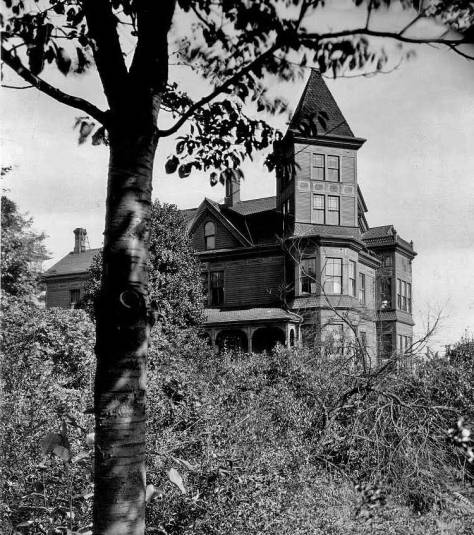
Boren Avenue is on the right of this detail from the 1904 Sanborn Real Estate Map. The Ward home, bottom-right, is marked with a “D.” What we have described as the T-Shaped home appears here left-of-center, on the west side of the alley. It’s “T-shape” is evident but not so marked as in the photograph (it seems to me). Note that it is also inscribed as “lodgings.” The other home depicted in the feature photo from ca. 1892 appears in the upper-left quarter of this detail, and faithfully too. The dark point first tree is not included. All the other structures – other than the T-Shaped lodgings – foot-printed in the lower-left corner of the detail are new since 1892.The Ward Home at the southwest corner of Pike Street and Boren Avenue, and just of frame to the right in the featured photo at the top. (The clip for its short story is included near the bottom of this week’s feature.)
which was built in 1882 at the then ungraded southwest corner of Pike Street and Boren Avenue. Wonderfully, it survives nearby at the northwest corner of Denny Way and Belmont Avenue, moved there about thirty years ago by attorneys – and preservationists – David A. Leen and Bradford Moore. It is probably the second oldest structure in Seattle, after the Doc Maynard home in West Seattle.
A recent capture of the Ward home at the northwest corner of Denny Way and Belmont Avenue.
The wide horizon of McDonald’s pan, above the north shore of Lake Union, extends from the then young mill town Fremont on the left, through Edgewater (a name rarely used today) to Latona (now part of Wallingford) on the far right. Brooklyn, the preferred name for the University District in the 1890s, is hidden behind Capitol Hill. Pine Street runs left to right through the center of the pan. It was the first graded street to reach Capitol Hill, and the 1891 Birdseye confirms it. Pike, however, was also soon extended to the Hill and became much the busier street with trolleys and commerce.
A detail of 1001 Pike Street, its west and south facades, pulled from the featured photo at the top. Follows, next, several Seattle Times clips of classifieds for goods and/or services available at 1011 Pike.Appeared Jan. 7, 1902 in The Seattle Times.April 29, 1908, The TimesJuly 11, 1909December 6, 1910November 24, 1911December 16, 1915.
During his Seattle stay, McDonald recorded several other panoramas, including at least four from Queen Anne Hill, two from Denny Hill and two more from First Hill. I think it likely that by 1893 McDonald had returned to that other “city of hills,” San Francisco, where most of his surviving prints are found in scattered collections.
Another of the several panoramas McDonald made in Seattle during his stay here in the early 1890s. [Courtesy, Museum of History and Industry aka MOHAI] CLICK CLICK CLICK to enlarge.Appear first in Pacific Mag.
WEB EXTRAS
Anything to add, Paul and Ron? A few more past features clipped by Ron Edge and placed by Ron Too. I wrote the text for the pan, first clip below, for what occasion or publication I no longer remember. But one of the last points the text makes is a challenge to the reader to find in that pan the place where the future Roosevelt Theatre would be parked. And so we included as the second “web extra” a feature done a few years ago on that the modern Roosevelt. At the bottom of this group is a detail taken from the featured photo at top, which shows both the mansion and farm house of the Pontius Family in what is struggling to still be called the Cascade Neighborhood (if it can survive Amazopolis) after its grade school, which was a victim to the 1949 earthquake. It follows the last of the Edge grab-links, which is also about the Pontius farm house, and appeared here not so long ago – sometime this past summer.
======
THE PONTIUS HOMES as REVEALED by MCDONALD
In this detail from this week’s feature McDonald pan we find, left and right, respectively the Pontius Mansion (with the tower) and their earlier farm house, which was feature on a recent Sunday, and included above as the last of the Edge Links. Click on it please – too. The Pontius family and mansion were part of the mid-40th series on local big homes that appeared on Sundays in The Times. AFTER extended frustrating attempts to place the farm house it was McDonald’s pan that led me to it. CLICK THE PULLED CLIPPING SEVERAL TIMES TO ENLARGE.CLICK CLICK to ENLARGE
=====
The RETURN of the WARD HOME
First appeared in Pacific, January 3,1999.The Ward home at its new home since the 1980s.
=====
Don Logan’s thrill. Recently deceased, Don taught at Ballard High School for many years.
=====
First appeared in Pacific, March 7, 1999. Update. The Van Siclen is gone now for a few years and replaced by a high-rise condo with class and cost.
=====
Another Cascade Survivor
=====
=====
ANOTHER EARLY 1890S LOOK TO LAKE UNION
LAKE UNION from Capitol Hill with the still familiar curves of Eastlake laid here for trolley tracks to Brooklyn, now better known at the University District. Fremont is the established clutter between the two first on the far shore. Queen Anne Hill is on the left. [Courtesy, Rev. Dennis Andersen, yet another Lutheran]=====
TOMORROW we may proof read. But now off to Nighty-Bears. Shhhhh.
(Lantern slide Courtesy of Bob Monroe. “Nighty-Bears” courtesy of William “Bill” Burden”)


![THEN: Looking north-northeast from a low knoll at the southwest corner of Seneca Street and Seventh Avenue, circa 1916. By 1925, a commercial automobile garage filled the vacant lot in the foreground. [Courtesy, Ron Edge]](https://i0.wp.com/pauldorpat.com/wp-content/uploads/2014/11/seneca-7th-mr-then.jpg?resize=474%2C353&ssl=1)


![Looking north across Mill Street (Yesler Way) from the frame box that once housed Kellog's drug store on the main floor and, for a few months, the Sammis photography studio upstairs. [Courtesy, Lawton Gowey]](https://i0.wp.com/pauldorpat.com/wp-content/uploads/2015/10/front-st-lk-n-over-yesler-ca-1887-web.jpg?ssl=1)


![A local news clip from the Dispatch for Oct. 28, 1878. [Courtesy, Ron Edge Newspaper Collection]](https://i0.wp.com/pauldorpat.com/wp-content/uploads/2015/10/x-clip-mills-clip-10-28-78-web.jpg?ssl=1)
![The opposite direction, looking south on Front through its intersection with Cherry Street, with the front facade of the box-shaped two story commercial building holding the Kellog Drug store centered on the south side of Mill Street (Yesler Way). Note that the scrawl on the mud of Front Street just above the worn foot crossing on Cherry, dates this scene 1878. [Courtesy, Seattle Public Library]](https://i0.wp.com/pauldorpat.com/wp-content/uploads/2015/10/kellog-front-st-s-fm-bwixt-columbia-cherry-74-web.jpg?ssl=1)


![Another of the several panoramas McDonald made in Seattle during his stay here in the early 1890s. [Courtesy, Museum of History and Industry aka MOHAI]](https://i0.wp.com/pauldorpat.com/wp-content/uploads/2015/10/mcdonald-denny-hlll-to-capitol-hill.jpg?ssl=1)


![LAKE UNION from Capitol Hill with the still familiar curves of Eastlake laid here for trolley tracks to Brooklyn, now better known at the University District. Fremont is the established clutter between the two first on the far shore. Queen Anne Hill is on the left. [Courtesy, Dennis Andersen]](https://i0.wp.com/pauldorpat.com/wp-content/uploads/2015/10/x-lake-unon-fm-cap-hill-ca-1890-web.jpg?ssl=1)
