
(Click and click again to enlarge photos)


Published in The Seattle Times online on Jan. 11, 2024
and in PacificNW Magazine of the printed Times on Jan. 14, 2024
A drowned ghost town reemerges in times of intensified drought
By Jean Sherrard
“A new-world Venice.”
That’s how The Seattle Times described a “little village” seven miles south of North Bend and 35 miles southeast of Seattle. Photos accompanying the May 14, 1915, front-page article provided dramatic evidence. Most of the burg’s 200 houses were half submerged by slowly rising flood waters.
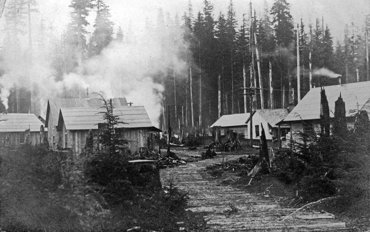
A company town, Moncton, was established in 1906 by the Chicago, Milwaukee and St. Paul Railroad while carving its transcontinental line through Snoqualmie Pass. It thrived on the picturesque Rattlesnake Prairie within the Cedar River watershed.
Rail workers soon were joined by utilities employees from nearby Seattle water and hydroelectric dams. By 1909, the town boasted a grocery, hotel, saloon and 30-student school. The town, less than 3 miles from Cedar Lake, Seattle’s primary water reservoir, was euphoniously renamed Cedar Falls. It must have seemed an idyllic spot to plant roots.

In 1912, City Light began building an imposing masonry dam intended to further harness Cedar River waters to supplement Seattle’s increasing electrical needs.
Cue ominous music.
Consulting geologists cautioned that surrounding valleys were comprised of porous glacial moraine unsuitable for water containment. But their warnings were overruled by J.D. Ross, Seattle’s superintendent of lighting.

Cedar Falls paid the piper. Soon after completion of the masonry dam in early 1915, springs erupted from surrounding hills and seeped up from the formerly dry prairie. By summer, all but two families had departed their flooded homes and were living in boxcars or makeshift houses above the rising waterline.
Initially, Seattle Mayor Hiram Gill denied responsibility, blaming the flooding on natural causes. After months of dithering, wiser heads prevailed. The town was condemned and its dispossessed residents compensated for their losses.

Amy LaBarge, Seattle’s current Watershed Management Division director, has watched Rattlesnake Lake rise and fall for decades. In December, after months of drought, the lake’s water levels dropped to the lowest she’s seen. “Our summers are definitely getting longer and warmer, and therefore drier,” she says.
A trained forest ecologist, LaBarge notes that volatile and extreme weather patterns are associated with increasing frailty of the forest ecosystem. “Over the last few years, we’re seeing alarming waves of tree mortality,” she says. “Multiple species have become highly susceptible to things that wouldn’t normally kill them.”
How, then, to manage future water supply in a climate changing world?
“Humans will have to learn to be very, very careful with how we use non-renewable resources like water,” LaBarge says. “We must conserve — not just for people, but for salmon and wildlife and all the other beings that call this place home.”
WEB EXTRAS
To see Jean Sherrard‘s 360-degree video of the “Now” prospect and compare it with the “Then” photos, and to hear this column read aloud by Jean, check out our Seattle Now & Then 360 version of the column.
Also, a few more photos.


Throughout the dry lake, evidence of the abandoned town can be seen in old growth stumps and structural remains (click for full size).


You might want to check your video production settings. On the Youtube 360° video, all the supplementary photos were mostly off the screen.
Hi Bret,
If you take a look at the 360 degree video in full screen mode, you can explore and examine any part of the video using your mouse to view in any direction. The extra photos can be viewed in the same fashion, pulling down with your mouse until they square up.
The locations detailed here are recorded archaeological sites listed in the State’s restricted database (WISAARD), and you provide enough information in your text and images that folks can figure out the exact location you are describing. It’s generally a bad idea to publicize the location of known archaeological sites, because publication of that information leads directly to illegal looting. For example, I have seen comments on the Times page about folks metal detecting at this location; that type of activity is illegal at this location under RCW 42.53.060 and is encouraged by publication of location information. That’s why information of that type is specifically exempt from public disclosure under RCW 42.56.300.
As a professional archaeologist, I share your enthusiasm for stories of this type. However, in the future I ask you to please consider the impact that publication of certain information can have on preservation of the archaeological record, among other concerns. Specifically, if a location lies in ruin and is accessible, it is probably an archaeological site protected by state law. Thank you for considering.
This was very interesting! Thank you for posting and the time it takes to research and create the content! We appreciate it.