THEN: Chalk-written real estate notices to the sides of Seattle’s Aurora Speedway in 1937 prelude by several decades the profession’s book and computer listings and the expectation of some that an agent will now be driving a Mercedes. (Courtesy, Washington State Archives, Bellevue Community College branch.)NOW: John LaMont, Seattle Public Library Genealogist, confirms that the house on the far left of Jean’s contemporary repeat is the same as that on the far left of the “then.” He adds that “the King County Property Report shows that it was built in 1908.”The relevant example of a Washington State Archive (Bellevue Community College Branch) tax card for King County structures 1937 and on.
Here we dip again into King County’s great archive of depression-era street photographs, with the Works Progress Administration (WPA) record of every taxable structure in the county – even sheds as modest as this one at the northeast corner of 81st Street and Aurora Avenue. The county’s “tax card” indicates that this “residential-business” zoned crib was built in 1928, that last full year of promised prosperity.
The North Side Realty was founded in 1926. Jesse M. Warren, the firms’ president, was described in the “Kind Words Club Year Book” for 1929 as one who showed “feverish efforts to transform our population into 100% landed gentry.” The “tall, medium build, hazel eyes, brown Hair, not balding” Warren’s camping and fishing trips were described as doubling as “under-cover operations for the inspection of possible townsites.” In 1930 Warren staged a role-playing theatre in the ballroom on the University District’s Wilsonian Hotel. Allowed three minutes each, salesmen from competing real estate firms attempted to sell imaginary houses to purported customers. Warren was then chairman of the Seattle Real Estate Board of Governors.
Not a CRASH of any sort! Seattle Times – Oct. 6, 1933
The sidewalk snapshot on top was recorded for the King County Tax Assessor during the summer of 1937, a year when the “Great Depression” that first crashed in 1929 was taking yet another dive. Soon Jesse Warren would return to what the graduate of Columbia University was trained for: architecture. In 1949 he led one of twelve teams designing “economy houses.”
From the Times: Jan. 31, 1937
Warren’s passion for populist home ownership, got the attention of The Seattle Times, which printed his plans on July 17, 1949. By then Jesse Milton Warren may have begun feeling out of sorts. His obituary for Sept. 5, 1953 has the architect, 65, dying after a long illness. The death notice made mention of neither his long life as a leader in local real estate salesmanship, nor of life on Seattle’s “north side.”
WEB EXTRAS
Anything to add, Paul? Yes Jean, and this time like many others before it, with the help of Ron Edge. First Ron has found a few of our former features that concentrated on Aurora. He introduces them with the three linking photographs below. These Aurora subjects will assuredly been used here before and perhaps more than once, but we are fond of repeating variations on our themes – here Aurora – even when they were used earlier in somewhat different contexts. After these three links, Ron has put up two wonderful opportunities for broad and often amusing research. I introduce the first of these – entrance to the city’s first numbered ordinances – with a introductory essay below that has several photographs of Seattle in the 1870s, the years of the ordinances found-or-linked here. Finally, Ron gives the reader a link to the large collection of newspapers/publications that can be searched through the state’s archival services. I, for one, have found reading in the Puget Sound Dispatch thru the 1870s both revealing and invigorating.
SEATTLE ORDINANCES – 1869 into 1880
Here Ron Edge has crafted from Seattle Municipal Archives sources a patchwork of Seattle’s first ordinances, beginning with incorporation in 1869 and following for 11 years thereafter. Ordinance No. 1 is dated Dec. 22, 1869 and is concerned “For the Prevention of Drunkenness, Indecent or Disorderly Conduct in the City Seattle.” Edge’s “clippings” continue on as far as Ordinance No. 207, “Appointing a Special Police Officer for the City of Seattle.” dated March 5, 1880. Some marked “obsolete” are blank.
Most of the 1878 Birdseye of Seattle. The then new King Street Coal Wharf is bottom-right. Yesler’s Wharf (above the smoking side-wheeler) dominates the more diverse waterfront commerce. [CLICK TWICE to ENLARGE]The virgin forest covering First Hill roughly east of 6th and 7th Avenues is recorded here from a backyard on Pine Street between Second and First Avenues, ca. 1872/3. The territorial university stands on its “Denny Knoll” top-center.Another look at the University on Denny Knoll, ca. 1874. Third Avenue with a fairly new sidewalk is bottom-right. The horizon shows a still forested Beacon Hill far to the south.
We consulted these ordinances to help us determine how Seattle’s First Hill neighborhood was cleared of its forest for streets and home sites – and when. The ordinances were at least helpful in this effort. For instance, Ordinance No. 140, dated July 2, 1877 records the street grade elevations from Alder to Pine Streets and from 7th Avenue to Elliott Bay. From the evidence of photographs it is our feeling that most of the clearing of First Hill between 4th and 7th Avenue occurred sometime between 1873 and 1877. Our best hunches – so far – narrow this effort to the years 1875-76. Ordinance No.140 encourages us in this editing.
Ron’s montage is a mix of documents and newspaper reports clipped from the Weekly Intelligencer and/or the Weekly Dispatch. Their printing is sometimes given color-of-the-times by other news appearing with – that is, to the side – of a few of the numbered and dated ordinances.
Another captioned pioneer photo from the albums assembled by Seattle’s journalist-historian (of the time) Thomas Prosch. Note the Dispatch office on the right. (With the others, this one is also matched beside its own hand inscribed caption, and used courtesy of the University of Washington Libraries, Special Collections.)
Included among the printed ordinances are a number of “Blue Laws,” decrees on how one may or may not behave on Sundays. The longest of the ordinances included here is No. 36, which lists the rules connected with the local cemetery. [Its dead have dominion.] No. 42 concerns “Indian Women,” and is painfully racist. In ordinance No. 43 bulls run free but shouldn’t be. In No.49 street vendors and medicine quacks are scolded and licensed and/or fined. No. 56, dating from May 7, 1874, deals with prostitutes. If you are one and get caught you may be fined from $5 to no more than $100. These penalties may be compared to those of Ord. 96, from Feb. 28, 1876. It has its eye out for those saloon merchants hiring female bartenders without a license. If one is caught the license still costs “$50 per quarter” with a fine as well “not exceeding one hundred dollars, or imprisonment not exceeding twenty days for every offense.” Ord. 96 is also hard on dancing.
Another Prosch contribution, this time looking west on Mill Street (Yesler Way) with the photographer’s back to Second Avenue. The Occidental Hotel is on the right, and Yesler’s Mill beyond the Pioneer Place flag pole. (Courtesy UW Libraries)The structures here on the right – south – side of Mill Street (Yesler Way) looking east from First Avenue, match well the structures in the photo above this one. This is perhaps the best early look east up Mill Street to First Hill where it begins its fall south to the ridge that attaches it to Beacon Hill. Here the flag pole and the Occidental Hotel are on the left. Asahel Curtis, the photographer credited bottom-left, did not take the photograph. In 1876 he was but a toddler of two. His family moved Washington Territory in 1888. One of the mature Asahel’s many projects was taking copy negatives of pioneer photographs, and then signing the results. The signature was certainly not meant to fool the consumers, but to control them.From his abiding affection for details in focused old photos, Ron pulls a detail here from aPeterson & Bros. print. It is an 1878 record of the Seattle Waterfront taken from the dogleg end of Yesler’s Wharf. Ron chose it for the cows. They are sort of posing on Front Street (First Ave.) between Madison and Spring Streets and at the subject’s center. The unchained cows are relevant to our promotion of the city’s ordinances from the 70s. Most of the larger farm animals get their own ordinances. It begins with Ordinance No. 2, which is for swine. Dogs get two – Nos. 5 and 45. Horses and mules appear together in Ordinance No. 16. Bulls appear in Ordinance 43, and very relevant to their detail in Ron’s print above, cows make it into Ordinance Nos 62, where they are titled as “Unruly Cows.” Read the ordinance itself for a description of what an unruly cow is capable and how they are punished. The date for No. 62 is Sept 3, 1874 and therefore four years before Peterson caught these cows unfenced on Front Street, and two years before Front Street was regraded from James Street to Pike Street. Also on Sept 3, 1874 the same City Council composed Ordinance No. 63, an eloquent complaint against that public nuisance cow bells. Ron notes that James Colman’s salvaged schooner the Winward is anchored at the bottom-center of the scene. The Puget Sound Dispatch was obsessed with it. If you do a key-word search of the Dispatch – and you can – you will find the paper’s stories on Colman’s drawn-out rescue of the steamer out of Useless Bay on Whidbey Island.
We have – you see – interspersed some photographs of Seattle in the 1870s between the few paragraphs of this introduction. Ron Edge has put up a link to the City Ordinances. It follows. In addition he also has a link to Washington State’s collection of online newspapers including the Weekly Dispatch, an often eloquent and sometimes muckraking newspaper publish in Seattle during the 1870s. Happy reading and sleuthing to all.
Above is the LINK to the state’s old papers archive. Above that is the LINK to the Seattle City Archives collection of the first city ordinances.
THEN: First Hill’s distinguished Old Colony Apartments at 615 Boren Avenue, 1910.NOW: After an 1990s restoration the Old Colony was made “like new.”As it was used in the Times for Jan 2, 1910. Photo-reproduction on uncoated pulp was thenstill splotchy.
When new in 1910, the Old Colony Apartments on First Hill at Boren and Cherry were touted in a Times classified as the “finest apartments in Seattle.” They were certainly the dearest. Of the 100-plus flats, apartments, cottages, and houses then listed by the agent John Davis, the $75 monthly rent for one of the Old Colony’s twenty-five 5-room apartments was tops. Inside, at 9&1/2 feet high the coved ceilings were also hovering.
A Times classified for Old Colony on Feb. 13, 1910
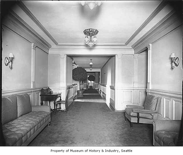
The view above of the Old Colony across Boren Ave. appeared in The Times for Jan. 2, 1910. It is described there as “handsome” and one month later in another classified as “the ideal home for those who know and appreciate the best.” A look into an elegantly appointed Old Colony apartment is printed on page 122 of Diana James book Shared Walls, the history of Seattle Apartment Houses that Jean and I both admire and lean on. By now we have made note of it three times or four in this column.
Hallway in the Old Colony
Preservationist James notes that Frank B. Allen, the Old Colony’s architect, was inordinately busy. Described as “the man behind the fair,” his firm was in charge of the “grouping and construction of the temporary buildings” at the 1909 Alaska Yukon & Pacific Exposition on the UW Campus. Perhaps in that administrative work the Architect first met the gregarious celebrity-politician, William Rupert Forrest. A former city auditor, city clerk and state senator, Forrest served as “special ambassador for the AYP to European countries.
William Rupert and Amelia Forrest are the first tenants of the Old Colony to make it on to the Times Society Page with Amelia’s hosting luncheons and formal dinners in their stately apartment. However, the couple’s life together at the Old Colony lasted little more than a year. William Rupert died of heart disease in their apartment on March 5, 1911. His lengthy obituary in the Times was often as playful as he, making note, for instance, of his extraordinary penmanship, a skill hardly valued now. Forrest could sign his name equally well with either hand, or using two pens with both hands at the same time – for the show of it.
[Click the Clipping below TWICE to Enlarge for Reading.]
The obituary for William Rupert Forest in The Seattle Times on March 6, 1911.
HIDE & SEEK: The OLD COLONY may be found in both the aerial above, dated Aug. 11, 1950, and the one below, with a circa date about the same. (Thanks to Ron Edge for sharing these.)
WEB EXTRAS
Anything to add, Paul?
Yes Jean – more of the same, nearly. Five pictured links below of past features (some fairly recent ones) begin with a link to local sculpture with many examples, most of them photographed by Frank Shaw. Following that are four links that cover the First Hill neighborhood principally or apartment living. Following the links we will continue with a few more appropriate features. Again and again we treat these postings something like musical scoring, that is, we don’t mind repeating some motifs in different contexts.
=====
Two views from 1937 and 1941 show big changes to the home at 609Boren. At the time asphalt siding was popular, a modern cosmetic. [Courtesy, Washington State Archive]The old First Hill residence was razed in the late 1960s for a parking lot. Next door the Old Colony Apartments at the southwest corner of Boren and Cherry endure. [Jean Sherrard]
WAR BRICK ON BOREN
Sometime between King County’s tax photographer visiting the modest Victorian at 609 Boren in 1937, and the second tax photo of the same home recorded in 1947, a siding salesman (sometimes in blue suede shoes) succeeded again in wrapping a depression-time home in “insulbrick” or Sears “Honor Built Brick Roll- Type Siding.”
Faux brick was the “aluminum siding” of the 1930s and continued to be sold in the 1950s especially in lower income neighborhoods crowded with modest workers homes whose strapped owners could not keep up with the demands of their fragile late Victorian clapboards.
The home at 609 Boren was built in 1895 on a brick foundation. In 1938 it was still a single frame residence for a Mrs. Augusta Sundell. By 1947 it had been converted into a rooming house, the Mary Ellen Annex Apartment. Probably the extreme housing shortage of the Second World War had something to do with the change. And the asphalt siding helped make it possible. Promising “no maintenance” it was a relatively cheap camouflage for the “home front.” Appropriately, it was then popularly called “War brick.”
Is it sobering to reflect that there was then a kind of siding hysteria for this imitation brick, and that, perhaps, the owner of the Mary Ellen Annex would sometimes stand at the sidewalk and compare the apartment with satisfaction to the “other brick” here on Boren, the Old Colony Apartments, next door to the south.
Above and below: another example of war brick at work, this one on
Lower Queen Anne. The repeat below was recorded by Queen Anne historian
Lawton Gowey.
=====
ASSAY OFFICE
(First appeared in Pacific, 2006)
If I have counted correctly there are here nineteen men posing before the U.S. Assay Office. Most likely they are all federal employees. Those in aprons had the direct and semi-sacred duty of testing the gold and silver brought then to this First Hill address from all directions. Of course, in 1898 the year the office opened, most of it came across the waterfront.
After the Yukon-Alaska gold rush erupted in the summer of 1897 Seattle quickly established itself as the “outfitter” of choice. Most of the “traveling men” bought their gear here before heading north aboard one or another vessel in the flotilla of steamers that went back and forth between Seattle and Alaska. The importance of the Assay Office was to make sure that when the few of these “latter-day Argonauts” who returned actually burdened with gold that they would be able to readily convert it to cash here in Seattle, for by far the biggest purchaser of these minerals was the U.S. Treasury.
Frank Shaw’s snap of the old Assay office on 9th north of James.I took this from Ron Edge’s car window on a recent visit with Rich Berner at his home nearby – also on 9th – in Skyline. I did not have Shaw’s earlier (above) shot either in hand or in mind.
In the competition with its northwest neighbors, by 1898 Seattle was getting pretty much anything it wanted it and so it also got this office and these “alchemists.” Still the anxious Seattle lobby worked especially hard on this for locals understood that having the assayers here considerably improved the chances that the lucky few might well spend their winnings here as well.
=====
Doctor/Mayor T. T. Minor
MINOR ON MINOR
(First appeared in Pacific on May 21, 1989)
Thomas T. Minor has a Seattle street named for him principally because he lived on it for such a short time. Thomas and his wife Sallie built their sturdy big home in the mid-1880s at the northeast corner of 12th Avenue and Cherry Street. The mansion was designed in a style that seems (to me) a mix of Italianate and Gothic styles then used with considerable flair by carpenters with a knack for ornament. Since there was a yet no central heating, all of the principal rooms had fireplaces. The Minors’ color choices for their home were dark green with a red trim.
Minor/Collins home facing Minor Avenue at its northeast corner with Cherry Street.Thanks to Google Earth for this street repeat.A page from the early-20th Century Beau-Arts book on Seattle’s then “finer homes”
Twice the mayor of Port Townsend, T.T. Minor was favored as an orator, and was honored with that assignment at Seattle’s 1882 Independence Day ceremony. The following year the family moved to Seattle, and four years later the eloquent Minor became the town’s mayor.
Minor was introduced to the Northwest in 1868 as a member of the Smithsonian expedition exploring the newly acquired Alaska for zoological and anthropological specimens. He soon returned to Port Townsend and quickly built a flourishing practice and fortune.
Looking across James Street and north on Minor Ave with Col. Haller’s Castlemount on the northeast corner. One block north on Minor a chimney of the Minor/Collins home finds the horizon.
His success came to a tragic end with an accident on a hunting trip in 1889 with two friends to Whidbey Island. They all drowned. 12th Avenue was renamed Minor. Sallie and their two daughters, however, soon moved, and John Collins and his family moved in. Collins had been Seattle’s mayor in 1873-74.
The shrewd Collins was the equal of Minor in enterprise. He came to Seattle from Port Gamble in 1868, purchased part interest in the then nearly new Occidental Hotel, the town’s best hostelry, and soon owned all of it. The Collins family home at the southeast corner of James and Second was destroyed in the city’s “great fire” of 1889. Collins lived in the Minor mansion until his death in 1903.
=====
The GAINSBOROUGH
(First appeared in Pacific June 22, 2008)
Built for class the high-rise apartment at 1017 Minor Avenue on First Hill was named after the English King George III’s favorite painter, Thomas Gainsborough. As a witness to the place’s status, Colin Radford, president of the Gainsborough Investment Co. that built it, was also the new apartments’ first live-in manager. And the apartments were large, four to a floor, fifty in all including Radford’s (if I have counted correctly). What the developer-manager could not see coming when his distinguished apartment house was being built and taking applications was the “Great Depression.”
The Gainsborough was completed in 1930 a few months after the economic crash of late 1929. This timing was almost commonplace and built on “works in progress” the building boom of the late 1920s continued well into the early 1930s. The quality of these apartments meant that the Gainsborough’s affluent residents were not going to wind up in any 1930s “alternative housing” like the shacks of “Hooverville” although the “up and in” residents in the new apartment’s highest floors could probably see some of those improvised homes “down and out” on the tideflats south of King Street.
Hooverville classic, looking north along the waterfront with the First Hill horizon, upper-right.The Hoge home “Sunnyscrest” in the Highlands.
Through its first 78 years the Gainsborough has been home to members of Seattle families whom might well have lived earlier in one of the many mansions on First Hill. Two examples. Ethel Hoge moved from Sunnycrest, her home in the Highlands, to the Gainsborough after her husband, the banker James Doster Hoge died in 1929. Before their marriage in 1894 Ethel lived with her parents on the hill near Terry and Marion. Ten years ago the philanthropist-activist Patsy Collins summoned Walt Crowley and I to the Gainsborough. After explaining to her our hopes for historylink.org she gave us the seed money to launch the site that year. Patsy was instrumental in preserving the Stimson-Green mansion, also on Minor Avenue, a home that her grandparents, the C.D. Stimsons, built in 1900.
The Stimson-Green mansion at the northeast corner of Minor and Seneca.The three views above all look east on Cherry Street from First Avenue. The top two are variations on the “Cherry Street Canyon” circa 1912 after the construction of the Hoge Building at the northwest corner of Second and Cherry on the left of both top two views. For a civic lesson in the growth of this Western American boom-town, the top two are compared to a scene from the 1880 Snow at the bottom. (Yesler’s pavilion is far-right, the city’s most popular venue then for public meetings and entertainment.) By the reckoning of the national census in 1880 Seattle, for the first time, showed a few more residents than were counted in Walla Walla. Both were less the 4000. By 1912, Seattle’s population was well beyond 200 thousand.
THEN: Twenty years ago the Mukai Farm and Garden on Vashon Island was designated a King County Landmark. (Courtesy, Vashon Maury Island Heritage Association)NOW: The “This Place Matters” enthusiasm of June 1, last, is wonderfully captured with Jean Sherrard’s big lens. He is not of course as close to the Mukai farm house and garden as is the “then,” because of the fence.
On the recent sunny Saturday afternoon of June 1, about 200 enthusiasts gathered beside – but not on – Vashon Island’s landmark Mukai farm and garden for a “This Place Matters” celebration and, it turned out, protest.
The enterprising Mukai family built this family home in 1926, and began then the artful labor of fitting the grounds with an elegant Japanese landscape, winding waterways about carefully set rocks, appointed with appropriate plants. The garden was supported by the success of B.D, Mukai’s strawberries, his nearby cold pressing process that packed the iced berries in barrels of his own making for shipment to distant markets. It was an enterprise that in season hired four to five hundred workers.
The builder and keeper of this traditional Japanese landscape was not so traditional. She was B.D.’s second wife, Kuni. First studying the Japanese art of landscaping, Kuni then designed the garden and continued to develop and nurture it from the late 1920s until World War Two, which on the West Coast upset the lives of nearly everyone of Japanese descent including the Mukais.
By now our Jean Sherrard may be considered something of a seasoned group photographer. On this occasion he was, however, surprised. “I arrived at the Mukai farm to find several hundred people assembling on a country road that runs in front of the farm. A black plastic fence posted with No Trespassing signs and two sheriffs’ squad cars kept preservationists off the land, squeezed onto the pavement. Mounting a 12′ ladder, I used a wide angle lens to capture both the home behind the fence and the protesters squeezed in front of it.”
Paul, I like to add in a few photos taken by my able assistant (and pupil at Hillside Student Community) Nick Anderson who, at 15, is not only a fine photographer, but an excellent actor and videographer as well. Here’s a few from Nick taken on that day:
The black plastic fence was liberally festooned with ‘No Trespassing’ signs, warning off the peaceful crowd, lest they attempt to “storm the property”. A couple of sheriffs’ squad cars were also present.
A wide selection of speakers encouraged the crowd:
Mary Matsuda Gruenewald, childhood friend of the Mukai familyDow ConstantineJean up on the ladderAnother of Jean
Nick’s shot from the Vashon ferry on that beautiful day
Anything to add, Paul? How about something on First Hill – its history. I have been asked (long ago) to write an introductory chapter for the Historic Seattle produced history of First Hill. In this line I became so fascinated with what is not known of that hill’s early life that I am woefully behind in producing my contribution. But now at last I have my motifs lined up and am writing. And so for the additions here I’ll begin with a First Hill scene, but then quickly follow with a few random Vashon snapshots.
First hill’s Coppins Water Tower and beyond it Central School taken from the highest point on the hill, Col.Haller’s Castlemount – its central tower facing Minor just north of James. This is from the 1890s.The “Mosquito Fleet” steamer Vashon parked at the Tacoma Municipal Dock. (Courtesy, Murray Morgan)The S.S. Vashon arriving at Burton.
The sternwheeler Vashon somewhere on Puget Sound. (Courtesy Jim Faber)Here we need someone from the island to identify the dock and perhaps the donkey. The banner tied to the green arch may depict strawberries.Another island scene having to do with gathering and celebrating strawberries. This one ca. 1916 by Lewis Whittelsy.We know no more than what is offered with this real photo postcard’s own caption.The Docton drydock (Courtesy, Dick Warren)Mike Cirelli posing at the stern/bow of the Vashon on the Seattle waterfront.Frank Shaw’s record of the Vashon on the waterfront, working as a hostel on May 6, 1985.
THEN: Many members of the Arthur and Mary Denny Family moved to homes on Boren Avenue, which were set back to back first on Seneca Street and then here at 1220 Boren, on University Street. (Photo by Asahel Curtis, courtesy of the Washington State Museum, Tacoma.)NOW: Barely a quarter-century old, Mary and Margaret Denny’s home at the southeast corner of University Street and Boren Avenue was replaced in 1927 by an upscale apartment house with a name – the Marlborough House – architecture and rents to sustain the neighborhood dream of refinement.
Seattle’s “mother” Mary Denny with its “father” and her husband Arthur moved from Alki Point to the forest on the east shore of Elliott Bay in 1852. There they kept close to the shoreline for nearly a half-century prospering while Seattle grew as rapidly as their many children.
When the city began its explosive growth in the 1880s and sustained it through the “great fire” of 1889 and beyond, many of the first and most fortunate settlers fled to the hills from the growing populist confusion downtown. But not the both prudent and confident Dennys who kept to their Gothic farmhouse, small barn, one milk cow and orchard on First Avenue where now the Seattle Art Museum embraces culture between Union and University streets.
Arthur and Mary Denny’s Carpenter Gothic home at the southeast corner of Union Street and Front Street (First Ave.) in which the couple raised their family and lived for more than 30 years until Arthur’s death in 1899 after which Mary moved in with her daughter Margaret on First Hill.The Denny home-site at First and Union now.
When Arthur died in 1899, Mary with her dedicated and still single daughter Margaret Lenora followed her oldest friends to First Hill, Seattle’s first somewhat exclusive neighborhood. They took to this stately Tudor mansion at the southeast corner of University St. – named earlier by Arthur for the State institution he delivered to Seattle – and Boren Ave. – named for Mary and her brother Carson’s family. Here they aged, and after a life of industry and considerable advantage their good fortune was inevitably mixed mortally with some bad.
Funeral announcement for Mary Denny in the Dec.31, 1910 issue of The Seattle Times.
By 1916 six Denny/Boren family funerals has been conducted here at 1220 Boren Ave, including Mary’s in 1911 and Margaret Lenora’s in 1915. At 88, Mary died of “natural causes.” Margaret perished extraordinarily in a wreck – a plunge into the Duwamish River from the slipper deck of the Allentown Bridge. From this home all the deceased were carried to the family’s grand tomb-site nearby at Lake View Cemetery.
Sensitive for how sexual roles have changed in the ensuing century, we may still be touched by how before his own death Arthur Denny described his Mary. “She has been kind and indulgent in all my faults, and in all cases of doubt and difficulty in the long voyager we have made together, without the least disposition to dictate, a safe and prudent adviser.”
[Click the below TWICE to enlarge.]
The Seattle Times March 31, 1915 report on the fatal for four Allentown Bridge crash.
=====
WEB EXTRAS
Anything to add, Paul? A few old related features Jean.
The line of residents of the big brick home at the northeast corner of Boren Ave. and University Street reveal how quickly changes came to First Hill. Built in 1904 for the Banker Manson Backus it became a boarding house during the Great Depression and was vacant when it was destroyed in 1956 to be ultimately replaced by the Panorama House. (historical photo courtesy of Washington State Historical Society.)The Panorama House, northeast corner University Street and Boren Avenue, in 2004.
THE BIG BRICK HOME of BANKER MANSON BACKUS
(Summer of 2003)
Thanks to a 47 year old tip from Seattle Times writer Alice Staples that may well be Carl A. Peterson at the wheel of the motorcar posing at the northeast corner of University Way and Boren Avenue. Behind the driver and his riders is the brand new over-sized home of the banker Manson Backus. Staples wrote a eulogy for the Backus home – and three others shown here – in the spring of 1956 when they were about to be torn down for a modern high rise. She interviewed Peterson.
For a half-century C.A.Peterson was a chauffeur of choice on First Hill. He drove for Backus and others and taught many of his employers to drive. He told Staples, “I watched them build this house in 1904.” Manson Backus the Second – the banker’s grandson — described for the reporter the red mahogany living room with a nearly 12 foot wide fireplace, the wide staircase that wound itself to the third floor, and his banker grandfather’s two electrically operated secret panels that he used as safety vaults.
The Mayflower descendent Backus came to Seattle from New York in 1889 with securities already in his pockets and started the (many times renamed) National Bank of Commerce. By the time the bank president moved into this big home he had lost two wives but had two children. His son LeRoy lived with his own family (including Manson the Second) next door on Boren, here to the left. As high-rise apartments first began to replace the mansions on First Hill many of its established families – Backus included – uprooted to the Highlands.
=====
At the northeast corner of Boren and Seneca, the Narcissa and Orin Denny home was to the rear – back to back – with the Margaret & Mary Denny home. It was eventually razed for a Sunset Club parking lot. The club survives across Boren Avenue from both the Denny Home sites.February 14, 1900 Funeral announcement for Narcissa Denny, who thereby barely outlived her father-in-law, Arthur Denny.
A late look at the Narcissa and Orin Denny home before its destruction for the Sunset Club parking lot. The club is picture directly below.
Postcard photographer O.Frasch’s look from a then new New Washington Hotel at 2nd and Stewart Street to the First Hill horizon north of Madison Street. For hide-and-seek (after first double-clicking the illustration) one may find the Summit School (far left), Waldorf Hotel, the stairs on Union Street from Terry Avenue to 9th Avenue, First Baptist Church (the spire), the three homes described above – for Backus, Margaret & Mary Denny and Orin and Narsissa Denny – and to the right of those the Stimson-Green Mansion; St.Pauls Apartments (at Seneca and Summit – see the detail from the 1912 Baist Map that follows), both the Unitarian Church and Dreamland on 7th Ave., Hotel Willard, the Normandie Hotel (with its three wings seen here from the rear), the Van Siclen Apartments on a steep 8th Ave. between Seneca and University Streets and, far right, the rear of the Sorrento Hotel, but not yet the Sunset Club.From Denny Hill, a similar point-of-view – shifted about one block to the right (southeast) and missing more than one block on the left (northeast). The still forested part of First Hill is the steep part between Seneca and Pike, 8th and Terry. It is so steep that is requires steps on Union and there is no thruway for vehicles on University to the east of 9th Ave.
A detail from the 1912 Baist Map that shows the impassable intersection of University Street and 9th Ave. on the far left. Blocks 116 and 117 show the footprints for Backus and the two Denny’s, and much else including the still surviving St. Paul Apartments at Summit and Seneca in the mutilated block 127 of the real estate map.The St. Paul Apartments, northeast corner of Seneca and Summit.
=====
The Ward Home at its original posture or position at 1025 Pike Street some brief time before it was moved in 1906 by 90 degrees clockwise to face Boren Avenue.The repeat on Pike for the Jan 3, 1999 feature in Pacific.
WARD HOUSE at BOREN AND PIKE
(First appeared in Pacific Jan. 3, 1999)
This view of George and Louise Ward’s over-sized home was sent to me last summer [1998] by Marianne Roulet, who came by it through her friendship with the descendants of Christine Johnson. Johnson arrived in Seattle about 1891, working as a cook until she joined fellow Swedish immigrant Sophia Anderson to open an early-century boarding house in the Ward home sometime after that family moved to new quarters. What is peculiarly delightful about this record is it shows the structure in its original attitude, facing Pike Street just west of Boren Avenue.
Frank Shaw – often appearing here – took this detail of the Ward tower on Dec. 30, 1977 when it loomed above Boren Ave. and before there were any intentions or efforts to move it.
This seems to be the best photograph (so far) of a home that has received a lot of attention – especially since attorneys David A. Leen and Bradford Moore answered Historic Seattle’s call to save this cherished landmark by moving it from harm’s way in 1985. A little more than a year later Leen and Moore were receiving clients in their new offices, the restored Ward House at Denny Way and Belmont Avenue, about seven blocks from its original comer.
A scene from the move and near its end.The Ward at the northwest corner of Denny Way and Belmont Avenue. Ron Edge snapped this on Oct. 29th 2012 from the driver’s window of his smooth Dodge wagon. We were headed for a First Hill visit with Rich Berner.
George and Louise Ward came from Illinois in 1871, settling on a farm south of town, then moving to Seattle for their daughter’s and son’s education. George used his training as a carpenter to build homes and soon also speculated with them. By 1880, he was a partner in Llw’ellyn and Ward, selling real estate and insurance and making loans. He also was active with the Seattle Cornet Band he helped found in 1877.
The Wards built their four-story landmark on the Pike Street slope to Capitol Hill in 1882. The home’s Italianate style probably fulfilled some architectural yearning for the Wards but by 1882 it was moving out of fashion.
Tabernacle Baptist, southeast corner of 15th Ave. and Republican Street on Capitol Hill.
George W. Ward’s funeral was’ held in Tabernacle Baptist church on Capitol Hill in the early fall of 1913. Ward was an active Baptist all his life, including his last 15 years as superintendent of the night school attached to the Japanese Baptist Mission here.
====
The startling differences between this week’s now and then are the results of 110 years of development. The older photograph looks northeast from a 4th Avenue prospect on Denny Hill. The contemporary scene [2003] was recorded in line with the old but from the top of the 4-story garage on the east side of Third Avenue.
FROM ONE HILL TO ANOTHER
(Spring of 2003)
When detailed panoramas like this rare look from Denny Hill to Capitol Hill are printed small we are left for the most part with describing impressions and larger features like the fresh grade of Denny Way, upper-right, where it begins to climb Capitol Hill.
The original print shares the photographer’s name, A.J.McDonald, on the border. McDonald is listed only in the 1892-93 Corbett Seattle Directory. Perhaps the economic panic of 1893 drove him back to California. The California State Library preserves a large collection of his San Francisco subjects but only a few Seattle scenes survive in local collections. Probably most of his Seattle subjects – maybe all -were taken during the photographer’s brief stay here.
The street on the right is Stewart, and its most evident part is the then still steep block between 8th and 9th Avenues. The large box-shaped building at the northwest corner of 9th and Stewart is home for Hendrick Bresee’s Grocery. He appears in the 1892-93 directory with McDonald. Ten years later it was J. M. Ryan’s Grocery. In 1910 the intersection was lowered fourteen feet. One block west at 8th Avenue Stewart was also raised with fill, thereby creating the contemporary gentle grade between 8th and 9th appropriate for the Greyhound Bus Depot built there on south side of the street in 1927.
In 1892-93 Westlake Avenue between Pike Street and Denny Way is still 15 years in the future and Virginia Street, one block north of Stewart, has not yet been developed through the two steep blocks east of 8th Avenue. Cascade School, one of the scene’s future landmarks opened in 1895. But the scene is dappled with many residents. All of them are relatively new, the creations of Seattle’s explosive growth in the early 1890s, including the Gothic steeple of the Norwegian Danish Baptist Church at the northeast corner of 6th Avenue and Virginia Street that appears at the border on the left.
Ten years before McDonald recorded this cityscape it was practically all forest. A few stragglers stand above City Park (Volunteer Park since 1901) on the rim of the ridge that in 1900 James Moore, its primary developer, named Capitol Hill. [For more on Capitol Hill history please consult historylink.org]
=====
When Norval Latimer (in the front seat) married Margaret Moore (in the back seat) in 1890 he was the manager of the pioneer Dexter Horton bank. When they posed with three of their children for this 1907 view on Terry Street with the family home behind them, Norval was still managing the bank and would soon be made both president and director as well.
Contemporary photo by Sue Champness
Historical photo courtesy of Jody Latimer Maurer
The LATIMERS of FIRST HILL
(Summer of 2006)
There are certainly two artifacts that have survived the 99 years since the historical view was recorded of the Latimer family – or part of it – posing in the family car and in front of the family home on First Hill.
The scene was almost certainly recorded in 1907 because a slightly wider version of the same photograph shows construction scaffolding still attached to the north side of St. James Cathedral’s south tower, far right. The Cathedral is the most obvious survivor. By the time of the church’s dedication on Dec. 22, 1907 the scaffolding was removed. The second artifact is the stonewall that once restrained the Latimer lawn and now separates the Blood Bank parking lot from the sidewalks that meet at the southwest corner of Terry and Columbia.
In the “now” Margaret Latimer Callahan stands about two feet into Terry Street and near where her banker father Norval sits behind the wheel in the family Locomobile. Born on July 22, 1906, Margaret is the youngest of Norval and Margaret Latimer’s children.
For a while, Margaret, it was thought, might be a third visible link between the then and now — although certainly no artifact. The evidentiary question is this. Who is sitting on papa Norval’s lap? Is it his only daughter or his youngest son Vernon? After polling about – yes – 100 discerning friends and Latimer descendents the great consensus is that this is Vernon under the white bonnet. And Margaret agrees. “I was probably inside with a nurse while three of my brothers posed with my parents.”
Margaret also notes that her father is truly a poser behind the wheel, for he was never a driver. Sitting next to him is Gus the family’s chauffeur with whom he has traded seats for the moment.
The clever reader has already concluded that Margaret Latimer Callahan will be celebrating her centennial in a few days. [2006] Happy 100th Margaret.
====
A likely year for this look north towards Lake Union and the north end is 1906. The Gas Works are being constructed on the “Wallingford Peninsula” and the Vacant Lot, near the subject’s bottom, at the northwest corner of Madison and Terry waits yet for the 1907 construction of the Sorrento Hotel. It seems possible – perhaps likely – that the photo was taken from the St. James construction site. There is certainly plenty of searchable landmarks here – so many that one could give a generous part of one’s retirement to identifying them all, and with the Seattle Times “key word” search opportunities thru the Seattle Public Library (merely with a library card) there are plenty of opportunities to learn about everything here – nearly – including what one can find by merely searching addresses, even imagined (guessed) addresses. The Backus mansion is here (looming right-of-center), as are the two Denny homes, back-to-back.


![Two views from 1937 and 1941 show big changes to the home at 609Boren. At the time asphalt siding was popular, a modern cosmetic. [Courtesy, Washington State Archive]](https://i0.wp.com/pauldorpat.com/wp-content/uploads/2013/07/2-609-boren-1937-1947mrthen-web1.jpg)
![The old First Hill residence was razed in the late 1960s for a parking lot. The Old Colony Apartments at the southwest corner of Boren and Cherry survive on the right. [Jean Sherrard]](https://i0.wp.com/pauldorpat.com/wp-content/uploads/2013/07/2-609-boren-now-mr3web1.jpg)


