THEN: Sometime around 1890, George Moore, one of Seattle’s most prolific early photographers, recorded this portrait of the home of the architect (and Daniel Boone descendent) William E. Boone. In the recently published second edition of Shaping Seattle Architecture, the book’s editor, UW Professor of Architecture Jeffry Karl Ochsner, sketches William E. Boone’s life and career. Ochsner adds, “Boone was virtually the only pre-1889 Fire Seattle architect who continued to practice at a significant level through the 1890s and into the twentieth-century.” (Courtesy MOHAI)NOW: During its construction of Interstate-5, the state’s Department of Highways set free the springs of First Hill, a fluid dynamics that required more pumping, concrete and time than expected.
For Jean Sherrard to record his repeat of George Moore’s historical portrait of Mercy and William Boone’s big home required both prudence and pluck. The latter took Jean to the edge of the concrete retaining wall that rises at least forty feet above the north-bound lanes of the Interstate Five Freeway. But it was prudence that kept him from leaning over the edge to reach closer to the prospect that George Moore took in the early 1890s. Both the home site and Moore’s position on Alder are now up in the air.
The Boone home is found in this early-1890s Sanborn map at the center, to the right of the block number 325, and the footprint for the King Country Court House is across Seventh Avenue in block 326. (Courtesy MOHAI) [To read the map – try CLICKING it. ]
The Boone home was constructed at the northwest corner of 7th Avenue and Alder Street in 1885. Boone was almost certainly the architect. During the summer of 1886, The Post-Intelligencer reports in its popular “Brevities” section that the fifty-four year old architect, “while working on his residence yesterday, fell from a ladder and sustained severe bruises about the legs. His injuries are not considered serious.”
The Boone home appears in this ca.1890 detail, which looks east from the King Street Wharf to the First Hill horizon and the Construction there of the King County Court House. The big home is half hidden in the trees and its own dark covering at the lower-right (northwest) corner of the Court House. The dark spreader leaning left from the mast on the right points directly at and even on the Boone home. The Terrace streets steps to the Court House seem to emerge from the smoke stack at the subject’s center. It was climbing those that in part inspired one of the most popular names for the first hill east of pioneer Seattle: Profanity Hill.Another and only somewhat later detail of the Court House also from the King Street Wharf. Here too are the wide but long wooden steps up Terrace Street, on the left, another mast (but no pointing spreader) and the Boone home, also half-hidden in the landscape.
Without committing itself to “First Hill,” the name with which we are accustomed, the January 29, 1886, issue of The Post-Intelligencer referred to the Boone residence as one of the “new buildings on the hill top.” Well into the 1890s the more popular name for this most forward edge of the first hill behind the waterfront was Yesler Hill. A name used in honor of Seattle’s pioneer industrialist – and employer – Henry Yesler. From the time he built his first steam saw mill in 1852-3, it was assumed that he would eventually clear the hill of its timber.
King County Courthouse look northeast from the corner of Seventh Ave. and Alder Street. The Boone home is out-of-frame to the left.
Sometime after the 1890-91 construction of the King County Courthouse, across 7th Avenue from the Boone home, a more playful place name, Profanity Hill, was inspired by the language used by lawyers and litigants who climbed the hill to deny and confess in the halls and chambers of the Courthouse.
The Yesler-Leary building designed by Boone when he was new to Seattle.The Toklas and Singerman Department store at the southwest corner of Front Street (First Ave.) and Columbia Street, destroyed by the 1889 fire.Henry and Sara Yesler’s new mansion was one of the first of Boone’s designs on settling in Seattle. This view looks at it southeast across James Street (and its cable car tracks), and includes the new (in 1891) King County Court House on the horizon. The Boone home is also on the First Hill horizon in the trees to the right of the Court House. (Courtesy, MOHAI)
Married in California in 1871, William, a Pennsylvanian, and Mercie, originally from New York, came to Seattle for good in 1882. That year he designed the landmark Yesler-Leary Building in Pioneer Square. Like the Toklas and Singerman Department Store (Boone’s design from 1887), it did not survive the city’s Great Fire of 1889. The mansion by Boone and partner then, the Californian George C. Meeker, was designed for Henry and Sara Yesler in the mid-80s just survived the greater fire ’89, but not its own on the morning of New Year’s Day, 1901. A few of Boone’s landmarks that are still remembered, but lost, are Central School, Broadway High School, and the New York Block.
Central School, designed by Boone, seen looking southeast across Madison Street between Sixth and Seventh Avenues. Note the Madison Street cable car tracks.Broadway High School looking northwest over the intersection of Broadway Avenue and Pine Street, from the Odd Fellows Hall.Boone’s New York Block during its destruction, Nov. 15, 1923.
William died in 1921 one year before his New York Block was razed for another and greater of the terra-cotta buildings that were then favored for the business district. Mercie died in 1923. They were both ninety-one years old. Although without children, Mercie was a leader in local charities, including the Seattle Children’s Home, whose first quarters her husband designed.
[We’ll add pictures of the first and second quarters for the Children’s Home. Most likely it it the first of these that Boone designed – and yet perhaps both. The first was built on property at the southwest corner of Harrison and 4th Ave. N., that was given and chosen by David and Louisa Denny from their donation claim. It is now part of Seattle Center. The second and grander home is on Queen Anne Hill property that is still home for the charity, although now in a newer plant. I worked there in 1966 as a house parent – the most demanding job I ever had. It soon turned me to painting canvases – and houses. ]
Seattle Children’s Home at 4th North and Harrison Street.Seattle Children’s Home on Queen Anne Hill.
WEB EXTRAS
Just paused for a bite in the I.D. and looked down King Street at our very own not-so-leaning tower with the Olympics looming behind.
And the spring rolls weren’t bad either….
I had to include a detail from the clock tower – note the support struts in the windows below (for an interior, flip down through this post from the past).
Clock tower close-up
Anything to add, lads? Sure Jean but first such a luxurious recording or our tower. It takes more than the right gear, light, atmosphere and mobility to record such a shot, it also requires meditation on that golden bar that mysteriously (we agreed) cuts through the tower and illuminates it’s golden clockworks, and so reminds us – some of us – that time is precious and we had better leave this scene and get with it. Here at my desk I have a bowl of Narcissus Daffodils for sniffing the early Spring – while writing.
Again, here are a few relevant Edge-links (named for Ron Edge who pulled and grouped them). Open these links and you will surely find other features with their own lists of relevant links and those links with theirs. The lead photo for the top link looks from the west side of 7th Avenue (like Boone’s home) north across Jefferson Street, or almost two blocks north of the Boones. The next link of the Sprague Hotel at Yesler and Spruce is about two blocks south of the Boones. And, again, so on.
======
OTHER BOONE DESIGNS
The Marshall-Walker Block (built 1890-91) on the right at the southeast corner of Main Street and First Avenue South. Long the home of the Elliott Bay Book Store, Allied Arts, and Jim Faber’s office. Jim wrote “The Irreverent Guide to Washington State,” although he was himself a saint.Plymouth Congregational Church, northeast corner of University Street and Second Avenue. You will find many stories that include it, if you key word them with this blog.The Wa-Chong Building in the old Chinatown at the northeast corner of Second Avenue and Washington Street, before the Second Ave. Extension. Part of the building survives. Here the Frye Hotel towers above and behind it.The Territorial Insane (they still called them in 1886-7 when it was bu ilt)) Asylum in Steilacoom.
=====
BEFORE THE BOONES and AFTER
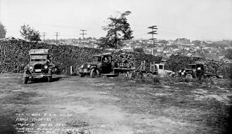
A panorama of Seattle seen from First Hill and painted in the 1870s. It hangs in the New York Public Library – either from the wall or in storage. Church in the shows and near the center of the canvas is the First Baptist Church at the corner of James and 4th Avenue, now site of the Seattle City Hall. Yes that’s the Olympics and not the Cascades, but how sweet it is to be so surrounded.The First Hill Horizon in 1881 from Pioneer Place (Square) during the 1881 memorial service for the slain President Garfield. In the past decade the hill was cleared of its forest and in the following decade it was filled with homes, like the Boones, and institutions, like the Court House. (Courtesy, Lawton Gowey)The encroaching 1-5 Freeway, upper-left, and Yesler Terrace Housing, upper right. The corner of Yesler Way and 7th Avenue is bottom-right with the old City Light transfer station to the west (left) of it.Freeway Construction showing the construction of the retaining wall below what was 7th Avenue.Freeway construction, recorded by Frank Shaw on April 16, 1964. Shaw looks south thru – or nearly thru – the former site of the Boone home at the northwest corner of Alder and Seventh.
======
Now up the stairs to Nighty-bears – leaving proof-reading until tomorrow. It’s nearly 3am.
Daffodils and dessert recently on artist Julie Paschkis’s’ kitchen table. And those napkins are also of her design.
THEN: The photographer David Judkins arrived here in 1883 and recorded this portrait of “Seattle’s first apartment house” sometime soon after. (Courtesy MOHAI)NOW: The First Interstate Center, renamed the Wells Fargo Center, was completed in 1983, the centennial for Seattle’s first apartment house.
This quintet of front doors, beneath a central tower shaped like a bell and a mansard roof that billows like a skirt in a breeze, was long claimed to be Seattle’s first apartment house. (It might, however, be better to call these row houses, each with its own front door.) The group was built at the northeast corner of Second Avenue and Marion Street in 1883*, a busy year in which Seattle also acquired street numbers and fifty-nine new neighborhood additions. It was also easily the largest city in the territory, with a census count that year of 6645 over Tacoma’s 3108, Port Townsend’s 1300 and the 1169 living in Spokane.
* We have learned in the first hour of posting this blog that it also slogs. The date of construction is off. First Dennis Andersen, the regional authority on architectural history, sends from Portland this letter to me here in my Wallingford basement. Dennis writes “Great image of the Stetson-Post townhouse row! But perhaps a small edit for the date, from the Seattle PI. ‘July 30, 1881, p.3 col 1: ‘Moving in. The resident block of Stetson and Post, on Second Street, is now ready for occupancy. Mr. Post’s family have moved into the building on the south. Governor Ferry’s family have got the carpets down and are preparing to move into the one selected by them. The finishing touches are being put on the other three, and they will be occupied soon’.” Thanks again, Dennis. Next, Ron Edge (who also put up the links below, most of them on row housing ) found another PI citation in the National Archives, this one from September 29, 1880, and we attach it directly below. Thanks again, Ron.
An entrance into the construction of the Stetson-Post “town-house row” clipped from the September 29, 1880 issue of the Post-Intelligencer.The Stetson-Post row is easily distinguished in this 1882 photo by Watkins about one-fourth of the way in (to the right) of the left border. Watkins took his panorama (this is but one part of many) from the King Street Coal Wharf. The new City Dock is under construction in the foreground.1884 Sanborn map with the Stetson-Post row lower-left.
Both “Stetson & Post Block” and “French Row Dwellings” are hand-written across the structure’s footprint in the 1884 Sanborn real estate map. It is named for its builders, George W. Stetson and John J. Post. Renting a shed on Henry Yesler’s wharf in 1875, and using Yesler’s hand-me-down boiler, the partners first constructed a gristmill for grinding grain into feed and flour, but soon switched to
Early intelligence of the partners Stetson and Post published in the Post-Intelligencer for February 8, 1878.Stetson and Post Mill photographed from the King Street Coal Wharf.
making doors and window sashes. By 1883 they had the largest lumber mill over the tideflats then still south of King Street. The Stetson & Post mill was equipped for shaping wood into the well-ornamented landmark that was their then new terrace here at Third and Marion.
It seems like this view of the row was photographed from about the same time as the featured photo on top – but what year? Our approximation: 1884. Note the home far left at the northeast corner of Madison Street and Second Ave, the home first of Dr. and Mayor Weed and later of John Leary, who moved from Stetson-Post with Weed moved out – most likely to his home at the northwest corner of Union and First Ave., or Front Street as it was then still called.The Weed-Leary home at the northeast corner of Madison and Second. Compare the bay window here on the Madison Street side, with that in the same home showing on the left of the photograph printed above this one. It has been “elaborated” – extended up to enclose the top floor too.
The Seattle city directory for 1884 has the partners living in their stately building, along with Thomas Burke, perhaps the most outstanding among the city’s “second wave” of pioneers. Other tenants were the dry goods and clothing merchants Jacob and Joseph Frauenthal, who had their own business block near Pioneer Square. The lawyer and future Judge Thomas Burke had his office in the Frauenthal Block.
If memory serves, that is Caroline Burke coming down the long stairway for her ride, perhaps.Here from about 1887 (I’m growing increasingly anxious about dates) the Stetson-Post appears to the right of the grand mansard-roofed Frye Opera House. Central School at 6th and Madison, appears on the far-right horizon (it burned down in 1888), and the dome of the Territorial University appears on the far left horizon. The city’s “Great Fire” of June 6, 1889 started in the joined buildings on the left with ten windows showing on the second floor. Budlongs Boat House in the foreground was saved by being towed off-shore. [CLICK to ENLARGE]The south facade of Stetson-Post appears on the left in this late-1880s parade scene photographed from Peiser’s “Art Studio.”A Sherrard repeat of the Peiser.Looking back over Second Avenue at Peiser’s Art Studio on the second lot south of Marion Street. Note te tent roof rigged for lighting.
Following the city’s Great Fire of 1889, which the wooden row houses escaped, the city rapidly rebuilt in brick and stone, expanding in every direction, including up. The Stetson & Post Block, which started as an elegant landmark visible from Elliott Bay, was soon hiding in the shadow of a seven-story business block, which was directly across Second Avenue, and named for Thomas Burke. The
The Burke Building northwest corner of Marion and Second, with a corner of Stetson-Post at the bottom-right corner. A. Wilse photographed this most likely in the late 1890s. He returned to Norway in 1900.
row houses then added commerce. In place of the five grand stairways to the five apartments, five uniformly designed storefronts were built facing the sidewalk on Second. And the city’s first row house or apartments (you choose) also changed it’s name to the New York Kitchen Block, after the restaurant that was its principal tenant.
The Stetson-Post with the commercial conversion of its stairs to shops. This dates from 1906 when the Empire Building behind it here at the southeast corner of Madison and Second, was still under construction. [Courtesy, Michael Maslan)A look north on Second Ave. from the roof of the then new Hoge Building, with the Burke Building here on the left, and both the Stetson-Post and the Empire Building filling the block on its east side between Marion and Madison. [CLICK to ENLARGE]
As noted by now far above, the 1884 Sanborn real estate map calls these attached homes “French Row Dwellings.” The Brits called them terraced housing. The many brownstones of New York are similarly arranged, and both San Francisco and Baltimore have rows of their architectural cousins – attached or semi-detached houses that are variations on a theme or several themes. Perhaps the most distinguished of the French rows is in Paris, the Place des Vosges, a 17th century creation.
The Burke and Stetson-Post looking across Second Ave at each other, cira 1903. The Empire is still four years in the future.The Golden Potlatch Parade of 1913, the “Dad’s Day” floats are in the foreground.Two years earlier for the 1911 Golden Potlatch parade, the Afro-American float passed in front of the Stetson-Post.The Stetson-Post and the Empire Bldg made a background for Uncle Sam appearing also in the 1911 Potlatch parade. [Courtesy Michael Maslan]
In 1919 the seventy-five-year-old George Stetson succumbed, as did his and John Post’s wooden block. A dozen years earlier, the critic F. M. Foulser, writing a nearly full-page essay on “How Apartment Houses are Absorbing Seattle’s Increasing Population,” in The Seattle Times for December 8, 1907, imagined the Rainier Block (the last of Stetson & Post Block’s three names) as “some aristocratic little lady of by-gone days, who has been compelled to remain among the influx of vulgarly new associates . . . and drawing her skirts about her, remains in solitary retrospection.” Some day, the essayist mused, “when the owner of the land on which ‘The Terrace of Past Memories’ stands, decides to accept the fabulous sum which is bound to be offered him, the old building will give way to a modern skyscraper.” It took some time. While the first replacement of 1919 gleamed behind terracotta tiles, it was, even when discounting the lost tower, still shorter than the row house. The forty-seven floors of the First Interstate Center followed in 1983.
However hard to read, even with double mouse clicks perhaps, here’s the full Foulser feature from the Seattle Times for December 8, 1907.A fine if modest two-story (or three) terra cotta adorned Watson Moore Stockbrokers home succeeding the Stetson-Post aka N.Y. Kitchen Block aka Rainier, here left-of-center. The Empire Bldg is far left.The First Interstate Bank was the last occupant of the corner, serving from a modern remodel of the ornate tile cover. Lawton Gowey took this on July 26, 1981. And he recorded its wreckage below on February 2, 1982.Looking east on Marion with the barely surviving south facade of the Interstate Bank at the center. (Lawton Gowey, 2/5/1982)In the fall of 1974 Frank Shaw framed the front door of the Pacific National Bank, precursor of the Interstate Bank at the northeast corner of Second Ave. and Marion Street, with the arch saved from the front entrance of the Burke Building with the construction of the Federal Building.
A survivor, the Stetson and Post Mill Company began promoting a “new plan” of delivering a “home from the forest to you.” It was a success. The company explained, because of its “ability to furnish the materials at prices well within reach” This, they explained, was possible because “the company owns its own timber, windows, doors, frames etc., employs no solicitors and sells for cash direct from the forest.” In 1926 Stetson and Post published a pattern book to encourage locals to build a variety of homes that were named, for the most part, after Seattle’s neighborhoods. Below are two examples. None of the forty-five or more “carefully devised plans” featured row-houses.
WEB EXTRAS
Anything to add, Paul? Yes Jean Ron and I though it most appropriate to feature a few past contributions that include some row houses. The last feature picked is the first we did on subjects included in Diana James recent history of Seattle’s apartment houses. It is titled, you will remember, SHARED WALLS.
And now we are going to climb the stairs to join the bears, so we will proof this after a good – we hope – night’s sleep.
THEN: Built in the early twentieth century at the northeast corner of Jefferson Street and Boren Avenue, Bertha and Frank Gardner’s residence was large but not a mansion, as were many big homes on First Hill. (Courtesy Washington State Museum, Tacoma)NOW: The Minor and James Clinic opened its new block-size brick home in 1988.
Judging from Asahel Curtis’s negative number 5479, inscribed at the bottom-right corner, this photograph of the home of Dr. and Mrs. Frank Gardner was taken on or very near 1906, the year which the King County tax records claim it was built. A more likely date for the construction is 1905. On the Society Page for The Seattle Times on March 10, 1905, Betha Gardner – then still more regularly called Mrs. Frank P. Gardner – is credited with hosting in her home, here at the northeast corner of Jefferson Street and Boren Avenue, the annual “at home” meeting for the “ladies of the Sorosis Club.” The Times added that “The subject of the afternoon will be the ‘Religion and Music of Russia.’”
[CLICK TO ENLARGE] This is NOT the 1905 Times clipping noted above, but another from nine years later in which Bertha Gardner and her Sorosis Club are noted. While enjoying a hide-and-seek for Gardner and her club you will survey a typical society page from The Seattle Times a century ago. Besides the long list of club activities there are some commonplaces, like the sensational advertisement at the bottom-left corner, and the seeming promise for a stretched figure from the adver. top-right promoting I. Isbin & Co, a ladies tailors on Third Avenue, and another fountain of youth (for your face) at the bottom-right corner. .Bertha Gardner’s portrait published in the Dec. 22, 1922 issue of The Seattle Times.
Pennsylvanians Frank and Bertha Gardner first lived on Capitol Hill in a more modest home. (Should you like to check it, you will find it surviving at 1629 13th Avenue.) By First Hill’s often sumptuous standards, their second home was neither small nor grand with ten rooms, five upstairs and five down. But the whole effect was pleasing in its symmetry, especially this west façade facing Boren Avenue, with its elegant but restrained ornamentation. There was nothing here so assertive, for instance, as the central tower on the Granville Haller home, seen peeking around the corner at the left of the Cardner home.
At the top of the hill, Granville O. Haller’s tower extended the superlatives of his big home at the northeast corner of James and Minor.A helpful detail from the 1912 Baist Real Estate Map – even without the street names. The bigger red dot marks the northeast corner of Boren and Jefferson, the site of the Gardner home, and the smaller dot rests beside the footprint for the Haller mansion at the northeast corner of Minor and James. Note, the red footprint upper-left for the Colony Apartments. It is one of the relevant Edge- links attached below. An essay – or perhaps even two – treating on the Haller home “Castlemount” will also be found in one – or perhaps more – of the links below. [courtesy, Ron Edge]
When the Haller home was built at the top of First Hill in 1883-5 at the northeast corner of Minor Avenue and James Street, some of the fir and alder forest that once covered the hill was still standing. While clearing the site, Colonel Haller’s workers uncovered the skeletons of two Native Americans, casualties, perhaps, of the 1856 U.S. Navy’s howitzer bombardments at the hill during what is popularly called the “The Battle of Seattle” in 1856. Known as the “old Indian Fighter,” Haller crassly kept the skulls in his tower for the amusement of the neighborhood’s children.
There is now a fine opportunity to study the diverse history of First Hill with Historic Seattle’s recently published book on the subject, whose title, while long, is both descriptive and pleasing to the ear: Tradition and Change on Seattle’s First Hill, Propriety, Profanity, Pills and Preservation. Both Pill and Profanity have been popular names for Seattle’s First Hill or parts of it, as have Yesler and, more recently, even Goat.
The increasingly “Pill Hill” part of First Hill photographed from Haborview Hospital in 1956, the year Bertha Gardner died. The Gardner home appears here directly below the large and dark three story (or four) apartment, upper-right. Her physician husband’s death preceded Bertha’s by twenty-six years. By 1956 she had moved to the University District. [CLICK TO ENLARGE]
Bertha and Frank shared their comely First Hill home until 1930 when the doctor died at the age of sixty-one. At some time during the 1930s, Bertha was joined by her brother Wilmer Kahle, president of the Crescent Manufacturing Company; following his death in 1943, she sold the house. We learn from her Times obituary of April 10, 1956, that at the time of her death she lived across from the UW campus in the Malloy Apartments on 15th Avenue NE, and that she had been a charter member of the Sorosis Club, and so dedicated to bringing together “representative women in art, literature, science, and kindred spirits.”
A Times clipping from Nov. 2, 1954 shows Bertha Gardner voting at the Wesley House polling station, which was one block south of her apartment in the Malloy, both directly across 15th Ave. from the U.W. campus. Bertha is fourth from the right and fifth from the left. The Churchill report on the left, may also be worth your time. CLICK TO ENLARGEThe Campbell home at the southwest corner of James and Minor. Their long front yard, which reached the block to Boren Avenue, was the Gardner’s “next door” neighbor. Across Minor Ave stands the Phinney home, far left. [Courtesy Lucy Campbell Coe]
WEB EXTRAS
Lots to add this week…eh, Paul?
Before we begin, however, I thought I would answer your request for more material with a feat of whimsical legerdemain. As you know, I teach drama and writing at Hillside Student Community. This past Friday, I took a few of my 5th and 6th graders on a field trip to the Woodland Park Zoo and through the miracle of photoshop, converted several into lion cubs.
Your students as metamorphs see wary, but not quite ready to leave the nest for the next step where it will be every cat for him or herself. We do have seven links Jean. Any reader who consults them thoroughly will find within most of the features we have done thru the years on subjects that border Boren. There are more than a dozen of them – unless I am contradicted. At the bottom we will ad a feature done first in 1985 about the Campbell home. With its park-sized front lawn it took the entire north-half of the block on which the Gardners built there home about twenty years after Campbell, a hardware merchant, built his in the mid-1880s. The youngest daughter, Lucy, was one of my earliest mentors on Seattle’s pioneer history.
And now for something completely different…
Back to our regularly scheduled program. Take it away, boys.
=======
The Campbell home at the southwest corner of James (on the left) and Minor (behind it).
[Please note that the number 24 in the header above refers to the chapter number in the book from which this text was scanned, Seattle Now and Then, Volume Two, first published in 1987 – if memory serves.]
The Minor an d James Clinic that replaced the home. I took this in 1985.
Lucy Campbell Coe in her Washington Park Home ca. 1985 – with a student.[CLICK & CLICK TO ENLARGE] Seen from Denny Hill, Seattle in 1885, the year Jesse, the Campbells oldest of three children, was born. On the right horizon stands the forest on Beacon Hill. Both the Minor and tower-topped Haller First Hill mansions appear on the left horizon – remembering that the Campbells lived kitty-corner to the Hallers. both at Minor and James. The “other tower” is Coppins Waterworks at the southeast corner of 9th and Columbia. Central School is temporarily near the center horizon. It burned to the ground in 1888. Second Ave. descends (in elevation only) from the lower-right corner.
THEN: Depression-era protestors climb Columbia Street sidewalk along-aside Seattle architect Harlan Thomas’s elegant Seattle landmark that opened in 1925 as home to the by then already forty-three year old Seattle Chamber of Commerce. (Courtesy, Museum of History and Industry)NOW: The Chamber moved from its landmark at 215 Columbia Street nearly a quarter-century ago. Among it residents presently is SEIU Healthcare NW Training Partnership.
The Seattle Chamber of Commerce building, its name signed with the luster of gold leaf lettering on each of the heftily-glassed dark doors on the left, is both physically and politically to the right of this cadre of about a dozen demonstrators marching east on Columbia Street up to Third Avenue. Seven of the patrol are wrapped in professionally produced signs that resonate with depression-era concerns and commands.
As it turned out the Seattle Chamber of Commerce’s full-page advertisement for July 25, 1937 was premature. The rise of the economy that was the trend in the beginning of July a month later began its moved in the other direction: down, which carried on for the year of what is called the “Recession of 1937-1938” in the Great Depression of 1929-1940. BLOW THIS ONE UP with some clicks to read the Boomer’s optimism that rings in-with-and-under it a a Real Presence of Commerce.
The original negative is one of the greathoard of Post-Intelligencer photos that are protected by the white-gloved hands of Museum of History and Industry archivists. It is numbered “PI22387” and, quoting MOHAI photographer Howard Giske, “It has a file date of July 15, 1937, on the old PI negative sleeve . . . good enough for me!” Alas, with the help of skilled librarians in the Seattle Room of our central public library, we did not find it in the paper itself.
While it is not unusual for a busy daily to neglect a negative, we will hope that a Pacific reader might visit the central library, and after a more dogged microfilm search than ours, find that this subject of a silent and yet telling moment of protest on Columbia Street was also published and captioned on the pulp pages of the P-I during the summer of 1937.
Meanwhile, for a better understanding of the subject, we recommend retired UW Archivist Richard Berner’s Seattle 1921-1940: From Boom to Bust, which covers local history during the bubbling 1920s up through the Great Depression of the 1930s. Berner notes (on page 409) that a recession, in the midst of the Great Depression, began in August 1937 when “Cutbacks in federal work relief funds coincided with unemployment levels that approached those of 1932-1933.” The timing is such that the event pictured in the ‘then’ photo, snapped in July by the P-I photographer, is prelude to the August recession.
The back cover with notable blurbs worth reading.
The “red-baiting” that we usually associate with the Cold War was also commonplace during the Great Depression, when communists were thought to be behind every placard. And here, far right, it seems they are. We may have a “commie” in the picture! Held like an umpire’s chest protector, a “newsboy” blandishes a copy of The Daily Worker, the Communist Party’s long-lived publication. Unfortunately, the focus is too soft to read the front page, which by 1937 could have included the latest baseball scores. Might it be that this confrontation of the two dailies, the P-I and the Daily Worker, was reason enough for the former not to print this negative? It is more likely that the bigger daily was distracted by the great mass of its own daily news. Or that we have simply missed it.
WEB EXTRAS
Anything to add, Paul? Well, yes Jean, and we struggled over selections from past features of protest or those, again, of the neighborhood. We get both in Ron Edge’s first link below. The others keep to both for the most part, although we have included some of Berangere’s recent reports from Paris. Following the eleven links attached below (and some of them will be very familiar to regular readers – like the Friends of the Market 1971 march in front of City Hall, which was the “top feature” here only two weeks past) we will continue with a few more neighborhood features. Our ending this week will show Jean’s photos of the public art fixed to the front facade of the Chamber’s building on Columbia (although they have long since moved away).
CLICK TO OPEN
======
The photograph above and the text below first appeared in Pacific May 15th, 1983 when the Times was sometimes still giving two page to this feature. (Courtesy, UW Libraries)Again, from the 5/15/1983 printing of Pacific. Imagine, now more than 30 years ago. The recommendation that the reader “(See feature 80)” refers to another now-and-then printed in the first of three Seattle Now and Then books. You can find it in the book folder on the front page of this blog.Fire Hill and Columbia Street seen from the Hoge Building at Second and Cherry. When it was completed in 1911, the Hoge was the tallest in Seattle, until it was soon surpassed by the Smith Tower. Although the Rainier Hotel is gone, leaving a block of scarred dirt, many other structures survive here from the featured Warner photo at the top of the text above.
======
If some smart readers still want a copy of “Washington Then and Now,” the address has changed. The new box is closer to home at the Wallingford Post Office. It is number 31636, Seattle, WA 98103)Looking back at Seattle from Elliot Bay in 1887-88. Yesler Wharf that elbows thru the scene will be turned to a stubble of pilings by the Great Fire of June 6, 1889. A year and a few weeks earlier Central School, the white box with tower on the left horizon at 6th and Madison, would be consumed by fire. Columbia Street runs up First Hill near the center of the panorama. CLICK TO ENLARGE!About ten years earlier, Peterson and Bros recorded this as part of a wide panorama of the city taken from the elbowed end of Yesler’s Wharf. That’s Yesler’s log pond in the foreground. First Hill has been recently logged off. Columbia Street climbs it, right-of-center. The log retaining wall holding Front Street (First Ave) above the tides was installed in 1876,
=====
If you hide-and-seek for this duplex in one of the Columbia Street revealing photos above it, you will find it.
=====
This subject appears as an extra with an essay in one of the eleven links offered near the top. We show it here to also show the little Post Office, at the alley on the right.Columbia Street, looking west thru Third Avenue during the latter’s 1907 regrade. The post office has moved on to First and University, and will soon be moving further into its headquarters at Third and Union. The next photo is earlier and shows the P.O..The Post Office is back, on the right beyond the alley. The retail brick on the left was predecessor to the Chamber building. The Boston Block just beyond it at the southeast corner of Columbia and Second Ave. , was built before the Great Fire of 1889 and after it packed with a great array of lawyers, salesmen, and the great array of desk duties involved in running a booming city.I took this repeat about a dozen years ago, which was two years or three before Jean took over the repeats. Bless him. Now we’ll take a closer looks at those two sculptured panels that adorn the Columbia Street facade of architect Harlan Thomas’ (with Thomas and Schack) Chamber of Commerce Building.Jean’s full-frontal of the Seattle Chamber of Commerce’s facade facing Columbia Street, with fragments of its neighbor, the Central Building, reflecting in its windows on a sunny autumnal afternoon in 2014. (Jean Sherrard)The up-hill relief sculpture – to the east or left of the front door – by Moran Padelford, who designed and formed it for his masters degree in art at the UW. It depicts indigenous crafts and so commerce too.Sculptor Mildred Stumer’s depiction of modern work – and so commerce. (Jean Sherrard)


![The Stetson-Post and the Empire Bldg made a background for Uncle Sam appearing also in the 1911 Potlatch parade. [Courtesy Michael Maslan]](https://i0.wp.com/pauldorpat.com/wp-content/uploads/2015/02/potlatch-parade-1911-uncle-sam-clown-stetson-empire-bldgsweb.jpg?ssl=1)


![A helpful detail from the 1912 Baist Real Estate Map - even without the street names. The bigger red dot marks the northeast corner of Boren and Jefferson, the site of the Gardner home, and the small dot rests beside the footprint for the Haller mansion at the northeast corner of Minor and James. [courtesy, Ron Edge]](https://i0.wp.com/pauldorpat.com/wp-content/uploads/2015/02/terrys-2nd-addition-block-97-lots-8-grab-web3.jpg?ssl=1)


![[Please note that the number 24 in the header refers to the chapter number in the book from which this was scanned, Seattle Now and Then, Volume Two, first published in 1987 - if memory serves.]](https://i0.wp.com/pauldorpat.com/wp-content/uploads/2015/02/campbell-home-text-part-one-web.jpg?ssl=1)