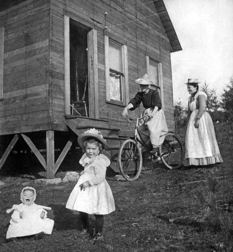
THEN: This look west from the West Woodland neighborhood toward Ballard comes by way of the Museum of History and Industry, with some help from both Ron Edge and West Woodland historian Susan Pierce.NOW: Susan Pierce, posing with her son Andy in front of the 1890s Jensen home, researches and shares information about her West Woodland neighborhood. Pierce lives across the street from the pioneer home.
Here’s an early mist-enveloped glimpse looking west into Ballard from the West Woodland corner of 4th Avenue NW and NW 60th Street. Turn around and the landscape rises sharply to the east, climbing Phinney Ridge to its Woodland Park summit. The homes of sawyers and other breadwinners have not as yet filled the blocks this far east from Ballard’s many lumber mills, although this West Woodland neighborhood has been nearly clear-cut and is waiting for buyers.
A detail from the Jensen home photo feature. Thanks to MOHAI for the featured print and to Susan Pierce for the the quartet of mostly tax photos below.
The modest and yet surely comfortable home, posing above with its residents at the center, dates from the 1890s. It was probably built by the carpenter-contractor Rasmus “Robert” Jensen, the man standing on the front porch with his wife Marie and most likely their daughter Anna. The lawn is fitted with a small orchard. In a later photo the fruit trees have multiplied and taken charge of the acres surrounding the home. These learned observations come by way of Susan Pierce. who is posing with her son Andy for Jean Sherrard in his recent repeat. Nine years ago Susan and her husband Blake moved into the home that stands directly east across 4th Avenue from the pioneer Jensen abode.
Flip side for the featured Museum of History and Industry (MOHAI) print.
From their kitchen window the couple look out upon the Jensen homestead. It is a prospect not far removed from that taken by, if we can believe the pencil note on the back of the original print (above), Broback Photo, an itinerate photographer from San Francisco. The original print, number 6446, is kept in the Museum of History and Industry’s “original photo file.” It is from these files that many grapevines of heritage study sprout – including mine. (I began my study of Seattle’s pictorial history with visitsto the MOHAI library forty-five years ago.)
This detail from the 1908 Baist Real Estate map reach from the west short of Green Lake on the right to the Jensen home at the northeast corner of “4th Ave. NW” and “N. 60th Street” at its bottom-left corner. It also surrounds the marked West Woodland Park Addition. Phinney Ave., the ridge’s spine or summit, runs up-down thru the center of the detail.Looking north on Phinney Avenue from 65th Street in 1937.
With her son Andy’s birth three years ago, Susan was awakened not only to nurturing her boy but the western slope of Phinney Ridge as well. These nourishing urges came together while taking Andy and her camera for perambulations around the neighborhood, and her research continued at home during Andy’s naps. By now the baby is a boy who can distinguish between a gable and a bay window. Susan opened both a Facebook page and blog on the subject of her neighborhood’s history. The results are admirable, and flourishing too, with over 600 users. With the help of her neighbors this genial grapevine keeps on growing. You may wish to review the fruits of these labors, either on the blog at https://vintagewestwoodland.wordpress.com/ or on Facebook at https://www.facebook.com/vintagewestwoodland
Front page to the latest edition of Susan Pierce’s blog, which you can enter by clicking the link above this illustration.
WEB EXTRAS
Anything to add, mates? First what we did NOT add – another video. The play is the thing. Jean has two more weeks of play production ahead and then we hope to resume the video treatments of these weekly features again. Otherwise we have more neighborhood features, some recent and some rather old. We start again with the more recent features pulled forward by Ron Edge. Click them to open them. We count “neighborhood” here as anything from Ballard to Green Lake, but still we have acted with restraint.
=======
JOHN B. ALLEN ELEMENTARY SCHOOL
=====
GRADING ON NORTHWEST 57TH AVENUE
=====
WOODLAND PARK (Northwest Corner)
First appeared in Pacific July 29, 1990
=====
SIMPSON BIBLE INSTITUTE
First appeared in Pacific July 27, 2003.
=====
First appeared in Pacific November 10, 1996.
=====
First appeared in Pacific March 4, 2001
=====
COLUMBIA LUTHERAN HOME
First appeared in Pacific on December 22, 1991.The Columbia Lutheran Home on Phinney Ridge, Courtesy of the Swedish Club
THEN: As the caption at the bottom allows, the Juneau Street footbridge opened for pedestrians on March 26,1915. It crossed the main track lines – not spurs – of three railroads and reached east from the Georgetown business district to a sprawling neighborhood of workers’ homes on the gentle slope of the Beacon Hill ridge. (Courtesy, Seattle Municipal Archives.)NOW: Had the approximately 200-foot long footbridge survived, it would have required a 300-foot extension to make it over the Interstate-5 Freeway.
In 1904 when the Seattle Brewing and Malting Company had nearly completed the construction on their oversize plant in Georgetown, the citizens there, at least 300 of them brewery employees, voted to incorporate. The citizens took to politics largely to facilitate the sale of booze and associated pleasures – to create a town free of censors, prohibitionists, and all but the least acquisitive of tax collectors. The brewery’s superintendent, John Mueller, won two of the new town’s most important positions: mayor and fire chief. The third position, chief of police, was paid well.
The pedestrian trestle still under construction, looking north along the tracks. (Courtesy, Seattle Municipal Archive)
Also in 1904, the brewery’s superintendent had a sincere talk with himself, the town’s mayor, about building, for the convenience of workers, a footbridge over the railroad tracks that separated the brewery from Beacon Hill, which is not so steep where it rises east of Georgetown. Although the footbridge was delayed for twenty years, the building of small workers’ homes to the east of the tracks was not. Many of these survive. On snuggly-fitted blocks 800 feet-long, upwards of thirty homes look at each other across streets, such as 16th and 17th Avenues South.
The Juneau Street footbridge can be found crossing the tracks just below the subject’s center. The brewery is on the left. (Courtesy, Seattle Municipal Archive and Ron Edge)A detail from the 1936 aerial. The trestle is gone, although its “scar” can be detected upper-left. (Courtesy, Seattle Municipal Archive)
When new in 1904, the 855-foot-long red brick brewery along Duwamish Avenue (Airport Way) was a few feet longer than St. Peter’s Cathedral in the Vatican. It was billed by its boosters as the largest brewery west of the Mississippi, and by 1912, after some additions were made, including greater ice production and doubling the size of the bottling works, the Georgetown brewery was listed as the sixth largest in the world.
CLICK & CLICK to ENLARGEJuneau Street Footbridge construction order, Dec. 9, 1914. (Courtesy, Seattle Municipal Archive)
Locally, Georgetown’s “cathedral to brewing” was described as the largest industrial establishment in the state in 1914, the year that plans for the Juneau Street footbridge were revived. The brewery covered the cost, about $3,300. A C.H. Stratton won the contract on Dec. 10, 1914. Expecting to complete the construction in ninety days, he ran only a little late. As the caption across the base of the featured print at the top notes, “Juneau S. footbridge Built 1914-5, Open 3-26-1915,” which may be the date, or close to it, this print was recorded. A second caption at the bottom of the negative is too faded to include here. It reads, “Secured by efforts of Dept. of P.W.” (Public Works).
This prohibition-era Sanborn Real Estate map shows the line of the foot bridge on the far right. The text, upper-right, explains that the brewery has been closed since Jan. 1, 1916, which was the start for Washington State’s dry years. CLICK CLICK to ENLARGE
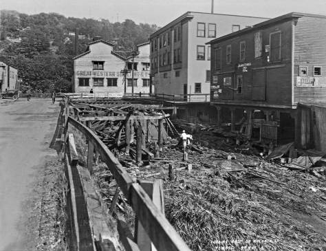
It was a different sort of “public works” that caused Georgetown’s growth and increasing optimism of the mid-teens to flounder. In 1916, the anti-saloon warriors and Washington State’s effective teetotaling legislators won the war against intoxicants by imposing statewide prohibition. Rainier Beer was moved to San Francisco. After midnight on Jan 1, 1916, bars were closed and all the jobs serving the imbibing culture – including those of hundreds of brewery and bar workers in Georgetown – were over. National prohibition, beginning in 1920, prevailed for thirteen often-farcical years of abstinence, until the breweries and bars were reopened in 1933. Months earlier, on Monday, Oct. 17, 1932, the deteriorating Juneau Street footbridge was closed to pedestrians and soon dismantled.
The Lander Street footbridge was another rail-crossing the city built for pedestrians in 1915. This Municipal Archive photograph is dated April 23, 1915.
WEB EXTRAS
Anything to add, chief? Not as much as we ordinarily contribute. We will make up for it in about one month when our now-then on the Georgetown RR Station will be featured. It is a neighbor within yards of the pedestrian bridge. We will treat on both subjects – the trestle and the station – then in our video, which since late last year has introduced the blog. The truth is that Jean is also busy producing/directing another play with his students at Hillside School (in Bellevue – see the link for the school on our front page) and I am happy to give more time to wrapping up “Keep Clam,” my long work-in-progress on an Ivar Haglund bio. Meanwhile here on some neighborhood-related features, plus a few bridges, from the blog’s recent past, which Rod Edge has pulled and placed.
THEN: Of the three largest Seattle roofs – the Alki Point Natatorium, a grandstand section of the U.W.’s Denny Field, and the St. James Cathedral dome – that crashed under the weight of the “Northwest Blizzard” in February 1916, the last was the grandest and probably loudest. It fell “with a crashing roar that was heard many blocks distant.” (Courtesy Catholic Archdiocese.)NOW: Jean Sherrard looks down through St. James Cathedral’s oculus, or ‘God’s Eye,’ during the special centennial service commemorating the dome’s collapse, which fortunately occurred on a Wednesday when no one was at church. I confess to having first used this rousing photo of the snow-doomed-dome of St. James Cathedral for a Pacific feature on March 17, 1983. (We will include it at the very bottom of what follows.) It was, however, not that Sunday’s “THEN” photo, which was a portrait of the intact cathedral, but played instead a supporting although still dominating role in the feature. Had Jean Sherrard been taking our ‘nows’ in 1983, it might have been different, for he embraces exposed heights that I shunned then and now.
John McCoy, past archdiocesan spokesman and author of A Still and Quiet Conscience, a biography of Seattle Archbishop Emeritus Raymond G. Hunthausen, first alerted us to the decision of the archdiocese to create a centennial commemoration of the dome’s fall. I next called Maria Laughlin, Director of Stewardship at St. James, to ask about the possibility of repeating the hole-in-the-dome shot from the Big Snow of 1916 during the commemorative service. She asked, “How does Jean feel about heights?” After I listed some of his ascents, she agreed to introduce Jean to Brenda Bellamy who would serve as his guide. Here’s Jean’s recap of the climb.
“After reaching the rooftop, we clambered through a small exterior door leading into the ‘attic.’ To avoid interrupting the centennial service below, we crept along catwalks and ramps in near darkness. Squeezing between struts and support beams, we climbed several ladders to reach our final destination: the oculus, a twelve-foot- (I’m guessing here) wide circular opening directly above the altar of the cathedral. My guide had already hoisted a snowmaking machine up onto the opposite side of the oculus, waiting for a dramatic, if necessarily truncated, recreation of the Big Snow of 1916 during the service.
St. James Cathedral – ABOVE & BELOW the original altar, before the crash. [Mea Culpa: I made the same mistake three times – here and the two photos following – of describing them all as records of St. James before the 1916 flop. They are rather the repaired St. James that followed the dome’s collapse. We learned this from Joseph Adam, a helpful agent of St. James itself. Thanks Joseph. We [well I, Paul Dorpat] will not do it again . Jean is clean and stays so.) The main altar and Sanctuary. The main altar was dovated by Mrs. Elizabeth Foss. The ***** and Foss altar railing ***** the gift of Mr. Patrick J. Henry in memory of his mother Michael J. Henry.
“I scooted around the upper outside edge of the oculus. While below us readers, quoting from newspaper accounts of the day, told the thrilling story of the dome’s collapse, I tried out different angles for our repeat. Particular culpability was ultimately reserved for the New York City engineers or fabricators who had assembled the dome’s flawed superstructure. It was allowed that Seattle and the Good Lord were blameless. At an appropriate moment, the lights dimmed and Brenda Bellamy switched on the snow-maker, sending a small blizzard of flakes down through the oculus and over the altar below. We then returned to the cathedral floor, where young Irish dancers were entertaining the congregants to the sound of pipes.”
Raised a Protestant, the centennial show has made me consider conversion.
St. James Cathedral – The original organ loft, before the crash.The organ after the crash – looking west from the chancel.The same (or nearly) point-of-view as the photograph above this one. This was taken in 2005 by Paul mere weeks before Jean started to increasingly record the “nows” for this feature. “What an improvement – and relief.” [Paul quoted]
WEB EXTRAS
Anything to add, Fra Paul? Brother Ron? Yes, and we can promise you and the readers more twin towers. We start, again, with Ron’s pull of relevant features – including on Protestant (3rd up from the bottom of the “Ron Links”) mixed in with a few more Catholics – posted here since we began doing these weekly duties. Then we will attach a few features from the distant past – again relevant ones. (And we will surely miss a few of the many First Hill features we have managed to assemble over the past thirty-four years.*)
======
First appeared in Pacific, November 7, 2004
=====
First appeared in Pacific, November 26, 1995.
=====
St. Benedict’s Wurst for 2011. CLICK TO ENLARGE
=====
First appeared in Pacific, September 2, 2001.
======
St. Josephs when nearly new. 18th and Aloha.
First appeared in Pacific, April 18, 1999.St. Joseph’s interior
=======
1907 – 2007
Saint James 1907 dedication, looking southeast thru the intersection of 9th Avenue and Marion Street.Temporary illuminated date for the 2007 Saint James Centennial.
THEN: Extended thanks to Ron Edge and his maps and aerials for properly siting Braun’s Brewery, to collector Dan Kerlee for letting us use this company portrait, and to Gary Flynn, the Bellingham-based breweriana collector and brewery historian.NOW: Because of Boeing Field restrictions, Jean Sherrard’s “now” was taken from a prospect closer to the line-up of brewery employees and their families in the “then,” than to the unidentified historical photographer.
Albert Braun arrived from Iowa soon after Seattle’s Great Fire of 1889. Or perhaps before. I we can trust the photo published below, Braun was here on the day of the fire and enjoying come cold beers at the beer garden that was then open at Pike Street and Front Street (First Avenue). The caption to his piece of Seattle Times nostalgia from 1934 makes some spirited claims.
The man sitting far left is identified as Albert Braun in this March 8, 1934 citizen-shared clipping from The Seattle Times. The caption is worth reading in toto.
Whether before the Great First or after it, within a year-and-a-half of the young German immigrant’s arrival here, with financial help from local and mid-western investors, Albert Braun built this brewery about two miles south of Georgetown. The then still serpentine Duwamish River is hidden behind the brewery. Directly across the river, on its west side and also hidden, was the neighboring community of South Park. Braun’s name is emblazoned on the brewery’s east façade, and so it was best read from the ridge of Beacon Hill and from the trains on the mainline railway tracks below.
Well into the 20th Century when the reproduction of photographs in publications left much to be desired, it was typical for businesses of size to use litho depictions of their homes and plants. This one of Braun’s brewery is peculiar. It includes structures (far left) that are not in the photo at the top but almost surely would have been include had they been built by the time of its recording. Also the litho puts Mount Rainier – if that is what it is – to the northwest of the brewery when it was the opposite. But then (and now) who is checking? (Courtesy, Gary Flynn)
The brewing began here mid-December 1890, and the brewery’s primary brands, Braun’s Beer, Columbia Beer, and Standard Beer, reached their markets late in March of 1891. The 1893 Sanborn Fire Insurance map for Seattle includes a footprint of the plant that is faithful to this undated photograph. The map’s legend notes that the buildings were “substantial, painted in and outside” with “electric lights and lanterns” and that a “watchman lives on the premises.” It also reveals, surprisingly, that the brewery was “not in operation” since July of that year. What happened?
A detail of the 1893 Sanborn map is printed in the bottom-left corner. Running left-right through the middle of the montage is a detail from the 1912 Baist Real Estate Map, and on the top is a detail from the current GoogleEarth space shot of the old brewery site. (Thanks to Ron Edge for assembling this.) CLICK to ENLARGE
The economic panic of 1893 closed many businesses and inspired a few partnerships, too. Braun’s principle shareholders partnered his plant with two other big beer producers, the Claussen Sweeney and Bay View breweries, to form the Seattle Brewing and Malting Co. Braun’s landmark was then designated as “Albert Braun’s Branch.” Of the three partnering breweries, this was the most remote, and it was largely for that reason – combine with the year’s panic – , it seems, that it was soon closed. The upset Braun soon resigned, sold most of his interests in the partnership, and relocated in Rock Island, Illinois. There, in quick succession – or simultaneously – he started work on a new brewery and fell in love, but with tragic results. Early in 1895 (or late in 1894, depending) Albert Braun committed suicide, reportedly “over a love affair.”
Pulled from the Seattle Times for October 1, 1899.
For six years this tidy Braun brewery beside the Duwamish River stood like a museum to brewing, but without tours. Practically all the machinery was intact, from its kettles to its ice plant, until the early morning of Sept 30, 1899, when The Seattle Times reported “the nighthawks who were just making their way home and the milkmen, butchers and other early risers were certain that the City of Tacoma was surely being burned down.” They were mistaken. It was Braun’s five-story brewery that was reduced to smoldering embers. The plant’s watchman had failed that night to engage the sprinkler system that was connected to the tank at the top of the five-story brewery. The eventually flame-engulfed tank, filled with 65,000 gallons of river water, must have made a big splash.
A clip pulled from The Seattle Times for August 11, 1900.
There is at least a hint that the brewery grounds were put to good use following the fire. The Times for August 11, 1900, reports that the teachers of the South Park Methodist Episcopalian Sunday School took their classes “Out for a holiday on the banks of the beautiful Duwamish River, (and for) a pleasant ride over the river to the Albert Braun picnic grounds.”
WEB EXTRAS
Anything to add, lads? Here’s Lady Rainier to cheer you on!
Cheers, Santé, Prost, and Skål!
Yup. Ron has found a few links that prowl the territory – widely conceived – and we have reached far for four or five more.
=======
One of the Hemrich brothers
First appeared in Pacific January 17, 1988. Directly below this photo is another of the same Bayview site, but earlier.Courtesy, Museum of History and IndustryThe same Bayview site – later.The Rainier Beer brewery during its years of service to Tully’s.Rainier Brewery reclaimedFirst appeared in Pacific on August 15, 1999.
One of the millions of barrels shipped and a few of the plants hundreds of employees.Seattle Brewing and Malting Co.’s Georgetown plant seen looking southwest over main line railroad tracks.Georgetown’s spiritless cathedral looking southeast over Airport Way. (Jean Sherrard – about a dozen years ago)A short stack of saloon advertisements pulled from the Dispatch for October 15, 1877.Joseph Butterfield and Martin Schmeig opened this brewery at the watefrtont foot of Columbia Street, the southwest corner, in 1865. It was not Seattle’s earliest brewery, but nearly. And it was the largest of the early breweries – those before the Bayview Brewery.Looking east from the elbowed end of Yesler’s Wharf to the waterfront at Columbia Street in 1878. The brewery is behind the first Colman Dock, far right. Columbia Street climbs First Hill from Front Street. In the foreground some of Henry Yesler’s logs float in his mill pond.
=====
BEFORE PROHIBITION
Beer on board – beer everywhere.
JUST 45 DRINKING DAYS LEFT (A Collection of Pioneer Square neighborhood saloon life before they closed in Washington State on the first day of 1916. Jean notices that here no women are to be found. The photographer for these 5×7 glass plates has not been identified eiher.)
CLICK TO ENLARGE
PROHIBITION
Confiscated hoochThe Seattle Times registers the public ambivalence towards the prohibition with a poll and prizes on “the prohibition question.!” A clip from March 7, 1926, still seven years before the end of it.
AFTER PROHIBITION
Jean notes the absence of men.
=====
Thanks to Gary Flynn the Bellingham-based “brewerian” for his writing on Braun’s brewery and many others. In 2010 Flynn received the American Breweriana Association’s Excellence in Literature award for “Outstanding achievement in supporting the objectives of ABA and the Breweriana community.”
Jean’s caption “Either the dark Demon Rum or a member of the Anti-Saloon League rides his ass to the bar.”A Rainier Beer advertisement with a typical topographical mistake. The Bailey Peninsula (Seward Park) is repeatedly imagined and depicted as an island in its most conventional composition from the Mount Baker neighborhood ridge above Lake Washington.