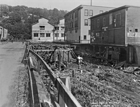
THEN: The Oregon and Washington Railroad Georgetown Depot was built in 1910 about two blocks north of the Seattle Lighting Company’s Gas Works, far-right. (Courtesy, Frank and Margaret Fickheisen)NOW: The short-lived O&W Depot sat on what is now the south side of the S. Albro Street Bridge that carries traffic across both Georgetown’s wide layout of seven railroad tracks and the I-5 Freeway. The Depot’s location is now a backyard for the small warehouses, equipment and blue tanks of Marine Vacuum Services Inc.
This portrait of Georgetown’s sharp but short-lived Oregon-Washington Railroad Station is the third “then” we have pulled from an album of snapshots shot and/or gathered by Henry J. Fickheisen. Henry was the son of Carl W. Fickeisen, an early Georgetown baker who started sweetening the Duwamish Valley with his cream cakes in the 1890s. Our first Ficheisen choice was a portrait of the Georgetown Volunteer Fire Brigade pausing and posing in uniform during a parade on Seattle’s Pike Street (Jan. 20, 2013. We will place it below as the second “Edgle Link” after Jean’s request for “Web Extras). Next we featured a sensational winter shot of Rainier Beer’s Venus fountain (Feb. 16, 2014). It was shown not flowing but frozen. (Venus will also appear below with the Web Extras: the fourth one. ) The depot photograph’s postcard qualities may make one wonder if Henry Fickeisen purchased it from a professional. But his album has many examples of personal snapshots of both family subjects and landmarks sensitively composed. Certainly we will feature other of Fickeisen’s early-20th-Century photos in future now-then features.
This shrouded look into Georgetown was photographed from the Seattle Lighting Co. storage tank seen on the far right of the featured photo at the top. It is dated November 30, 1910 and the new depot can be found at the center interrupted by one of the standpipe’s supports. Perhaps the featured photo was also recorded on this November day. The view from the top of the tank looks northwest towards Elliott Bay. I’ve no notion – yet – from where on the top of the gas storage tank Fickeisen shot this and survived it too. Had the tank been there now Jean would have followed.. (Double Click this to get at the details)The tank is seen here looking east from the part of the company’s trolley yards in Georgetown. This prospect is now part of Boeing Field.
On July 28, 1910, the Seattle Times noted some early work-in-progress at this station. “NEW DEPOT BUILDING foundation work has begun for the $5,000 passenger station of the Oregon and Washington Railroad at Georgetown. The new depot will be located north of Graham Street and west of Swift Street . . . The new station should be completed within a short time.”
The Times clip from July 28, 1910 noted above in the text.
Finding little else on the tidy depot, aside from the Times notice, I turned to Kurt Armbruster, Seattle’s encyclopedic rails historian, who answered with the photo below, which also includes the new depot.
Historian Kurt Armbruster helped in our sizing of the Georgetown RR Depot with this look at it on the right from the west side of the mainline tracks. Some of the towering east facade of the Rainier Brewery crowds the left border. The planks crossing the tracks to this side of the depot served as the first near-at-hand vehicular access between Georgetown and Beacon Hill. It was in line with Graham Street. The pedestrian viaduct in line with Juneau Street, which figured in an earlier now-then feature on this blog and can also be found in the “Edge Links” below, also shows here. (Courtesy Kurt Armbruster) CLICK TO ENLARGE
In this search, Kurt also reached rail archivist Dan Cozine, whom Kurt describes as “one of our region’s leading authorities on railroad facilities and owner of possibly the largest local collection of engineering drawings, official correspondence, and other historic railroad ephemera.” We learn from Dan that the Oregon-Washington Railroad & Navigation Co., regional subsidiary of the Union Pacific, built the depot in 1910. The building’s large waiting room, baggage room, and 300-foot platform indicated that it was intended as a suburban passenger station to serve the growing south Seattle area.
The railroad lines listed in the Times Clip above from July 12, 1911, all funneled through Georgetown and yet gave very little service to its depot. The locals used the regular street trolley to Seattle and the Tacoma Interurban too. As the clip below reveals, the trolley service was also later replaced – by buses.A Seattle Times clip from 1941.
These grand intentions, however, were not to be. Most Georgetown-bound passengers arrived by street trolley and not on a main line train. After the 1911 opening of the Union Pacific’s grand station at 5th Avenue and Jackson Street, few trains stopped at Georgetown. The frequent exceptions were those loading cases by the hundreds of Rainier Beer at the Seattle Brewing and Malting Company’s big brewery about two hundred feet to the north of the depot and across the tracks.
An annexation boosting clip from the Seattle Times for March 20, 1910. (CLIP TO ENLARGE)
Another reason, perhaps, that the depot received little attention was that in 1910 Georgetown was preoccupied with being encircled by Seattle. On March 20, the Times predicted “Georgetown Will Come In.” The newspaper’s list of advantages that would come with annexation into Seattle included Cedar River water, “high school privileges,” a much better police force “for the same price,” a move from “practically no street improvements” to “all she needs,” respected contracts and protected rights, her own councilmen (for the Fifteenth Ward), and something more than “a meager fire department” like the one that the Fickheisen’s volunteered for. The Times made no mention of trains or trolleys. On the 29th of March, the citizens of Georgetown decided on annexation and enhanced encirclement. They joined Seattle.
A TIMES clipping from Nov. 11, 1929 sampling news from twenty years earlier. Annexation was defeated with the first citizen vote on Nov. 11, 1909, but later won Seattle’s encirclement with the second. Here on January 3, 1926 Georgetown gets its turn in the Seattle Times coverage thru the 20’s of our neighborhoods and nearby suburbs. [CLICK TWICE to ENLARGE] This 1936 aerial, which was made for mapping, centers on the nearly new Albro Place bridge that crossed above the wide swath of railroad tracks and replaced the ground level plank-paved crossing on Graham Street. The remnants of this last can be detected as a lighter-shade of covering a little less than a block south (right) of the overpass. The disturbed ground cover on Juneau Street, which had supported the pedestrian overpass into Georgetown, can also be “sensed” to the north (left) of the Albro Bridge, about one long block distant. Half of the Seattle Electric Company’s gas tank is revealed at the photo’ s bottom-right corner. Part of the pre-prohibition Rainier brewery shows at the upper-left corner. (Courtesy: Museum of History and Industry)One of the hundreds of aerials shot by Laidlaw and kept in the Museum of History and Industry Archives. Many date from the 1930s, this one included. The gas tank looks on at the bottom-left corner. The Georgetown RR Depot is lone gone. It sat at (under) the east end of the Albro Bridge and so right-of-center here. The depot’s footprint can be found in the montage that follows. This view looks northwest and can be compared to the other northwest sighting taken from the top of the tank and include near the top of this blog. (Courtesy, Museum of History and Industry) CLICK TO ENLARGE & EXPLORE Here, again, upper-left is the planked Graham Street crossing the tracks into Georgetown. It is found at the bottom of the detail from the 1912 Baist Real Estate map, upper-right. There too can be found the promised footprint of the Georgetown Depot and its RR spur. The multifariously revealing 1936 aerial at the bottom has been “covered” above. CLICK TO ENLARGE
WEB EXTRAS
Anything to add, laddybucks? The seventeen “Edge Links” stacked below are all of the south-end subject – from “below the line” or south of Yesler Way. The second one is a kind of exception. Another Fickeisen photo – like the day’s feature – it follows the Georgetown Volunteer Fire Department to the corner of Pike Street and Seventh Avenue, most likely for a parade.
========
BELOW: NOT A LINK BUT ANOTHER AERIAL FROM MOHAI.
Another MOHAI AERIAL, this one looking south thorugh much of Georgetown (and the landmarks considered above) about a decade before the Seattle-Tacoma freeway – I-5 – pulled and pushed through here. Note the B-52s parked beside the Boeing runway. (click twice to enlarge)