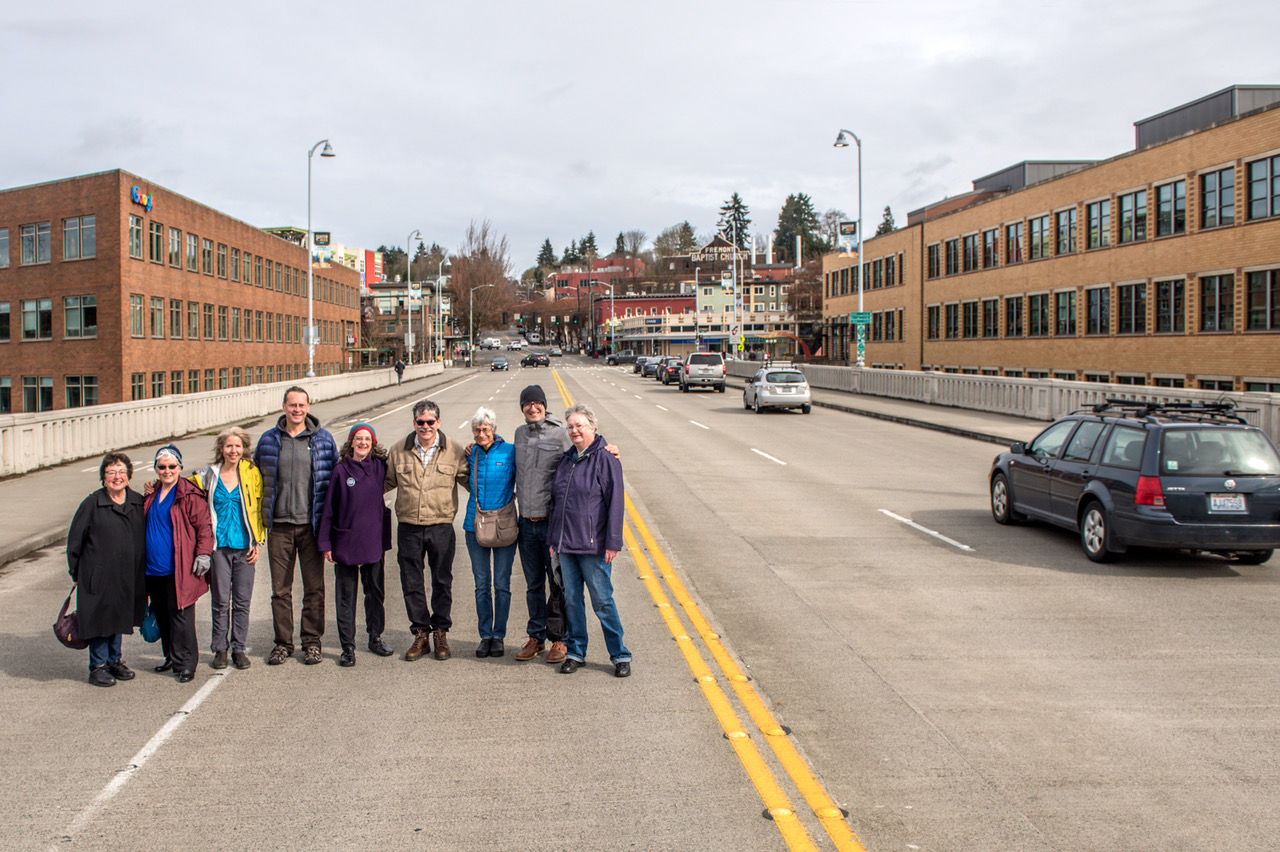
NOW: An uncredited photographer looks north on Fremont Street from its original intersection with Ewing Street (N. Northlake Way).NOW: Members of the Fremont Historical Society pose on the Fremont Bridge, prudently to the side of the busier northbound lane and also well ahead of the traffic advancing south from the 34th Street intersection behind them. Member Judie Clarridge, who helped arrange the “shoot,” stands on the far left side. She also advises that Valarie Bunn, far right, “does a good job about finding things” and was especially helpful in researching the featured photo. We should also note that Heather McAuliffe, the Society’s founder in 2004, is present and dressed in yellow and blue on the left. The Fremont Historical Society’s website is http://www.fremonthistory.org.
In line and alert, members of the Fremont Historical Society stand for Jean Sherrard’s “repeat” on the southbound lanes of the Fremont Bascule Bridge. The FHS members have just adjourned from their April meeting (the second Saturday) in the nearby conference room of the Fremont Public Library. The historians met in part to consider where to stand for the “repeat” of this week’s featured “then” and together study the inviting jumble of meanings included in the older photograph. The leading goals are, of course, to discover or uncover the “where” and “when” of the photograph, which, judging from the shadows, was recorded around noon. Although it came with no caption, the members easily knew, and in unison, that his was Fremont Avenue. They were less secure regarding its uncertain elevation. That will take more time.
Early during the members joint research someone noticed the sign exhibited, upper-left, in the second floor corner window of the clapboard business block. It reads “Mabel Canney, Piano”. Searches of city directories revealed that Mabel, and probably her piano, were located here in 1908 and 1909 but were then followed in 1910 by her younger sister Ella Mae. This, of course, strongly suggests that the Canneys were a musical family, but also that this subject looking north on Fremont Avenue was photographed sometime when one, or both, of the sisters was in residence there.
Details of downtown Fremont in details from the 1908 and 1914 (left and right) real estate maps of Seattle. (Courtesy, Ron Edge)The low Fremont Bridge looking north from the Queen Anne side in 1903A “real photo postcard” by Oakes looks north from the south slope of Queen Anne Hill (on 4th Ave.) to the Fremont Bridge at its old “low” level. Compete the retail storefronts lower-right to those in the later and first “high bridge” print that follows.An look across the temporary Fremont “high” Bridge on March 18, 1915. The attentive and/or clever eye will find here the top of the brick retaining wall that was built along the south side of 34th Street, It can be found between the two poles and one mill smokestack on the right and the bright white puff of steam right-of-center. There is also a larger and brighter part of the wall to be found on the left. Also the keen reader might wish to compare the grade of the businesses right-of-center with those in the earlier “low” bridge photo placed above this one. This is the “high” bridge repaired after the the center of its predecessor was swept away in 1914 when the dam at the Lake Union outlet broke, and lowered the lake by seven feet. The site of the broken dam seen from the temporary “high” Fremont Bridge in 1914. The pilings supporting the Stone Way bridge in the distance are awkwardly exposed by the sudden lowering of the lake.The low Fremont Bridge seen from the pedestrian bridge that crossed the Lake Union outlet at its dam ca. 1908.The Fremont dam and pedestrian bridge seen from the Fremont Low Bridge, probably in 1907. Note the distant standpipe, top-center, (near the subject’s center) of the Seattle Gas Company. It was brand new in 1907 and i\s now the site (of course) of Gas Works Park.The Fremont Bridge, looking southeast from the Fremont side in 1907. A pile-driver stands at the center.Looking southeast from the Fremont end of the “high” bridge repaired after the 1914 gush. The photo is dated March 3, 1915.The 1903 reconstruction of the outlet dam. Note that there is a yet no gas works on the Wallingford Peninsula. Dredging a Ross Creek Lake Union Outlet in 1903. Fremont’s lumber mill in on the left and Capitol Hill on the horizon. On might play hide-and-seek with the mill’s landmark stack. It can be easily found in several of the photographs above this one.
With the help and confirmation of other photographs, plus city maps – especially the real estate maps of 1908 and 1912 (as seen for inspection eleven photographs above) – and directories, the deliberating FHS membership could eventually calm the uncanny feeling that something was a kilter here. Through the years of building the Lake Washington Ship Canal, 1911-1917, there were big grade changes here.
A now-then feature looking north from the south side of Fremont Bridge in 1911. CLICK TO ENLARGE!!!First appeared in Pacific on June 22, 2003
In the featured photograph at the top in this first block south of the intersection of Fremont Avenue and Ewing Street, now 34th Street, Fremont Avenue was cut off and dropped below a retaining wall. In the process, both the mercantile building with the Canney piano on the left, and the mill warehouse on the far right, were settled to rest below the deck of the new but short-lived Fremont Bridge constructed in 1911-12. That was not the bascule bridge, which opened in 1917, but its penultimate span that reached N. 34th Street and the Fremont Business district at the new and still holding elevation. The investigating Society also discovered that the railroad track, which curves across the bottom of the subject, was kept to pass below the new Fremont Bridge. It was the Seattle and International Railroad spur that reached Fremont’s main employer, the Bryant Lumber Mill, to the right and behind the unnamed photographer.
Looking north along the north wing of Fremont’s bascule bridge on April 18, 1939.
WEB EXTRAS
Anything to add, lads? Yes Jean, those directly below that Ron Edge put up earlier this evening, and eventually a few more relevant features that I’ll pull from the archive after breakfast. It is 5:19 AM Saturday morning now, and I’m going to bed. Remembering now and in honor of Bill Burden its parent the kind good night “Nighty-Bears.” I climb the stairs.