THEN: Both of this week’s featured photographs were recorded from the same elevated prospect, but by different professional photographers: T. E. Peiser and D.R. Judkins. The latter’s can be identified by the studio sign that rises high, far left on a post at the southwest corner of Second Avenue and Columbia Street. Both photos date from 1886, and include different cues: the one of uniformed Knights of Pythias member-musicians marching south on Second and the other for the most part of primary students posing on the boardwalk. Both photographs also include, right-of-center, the home built by J.T. Jordon, Seattle’s second mayor, at the northeast corner of Second and Columbia, and left-of-center at the northeast corner of Second and Marion, the Stetson-Post Terrace, Seattle’s first swank apartments designed for its first ‘1 percent.’NOW: Jean Sherrard has used his extension pole to approach the elevation exploited by the two pioneer photographers on the second floor of a neighbor’s home on the west side of Second Avenue.
Pioneer photographs of any Seattle street other than Mill Street (Yesler Way), Commercial Street (First Ave. S.), and Front Street (First Ave. north of Mill Street) are rare. Here are two exceptions. Both are on Second Avenue and both were recorded from the same prospect – within inches of one another.
In the 1880s pioneer photographers Theodore E. Peiser and David Judkins set up studios a block apart on the west side of Second Avenue. They were competitors and almost certainly did not plan this propinquity. Peiser’s studio was on the second lot south of Marion Street and Judkins’ on the southwest corner with Columbia Street. The two professionals photographed parades of different sorts near their studios on Second Avenue, and only about six weeks apart.
I am long familiar with Peiser’s May 13, 1886 record of parading members of the secret society Knights of Pythias pausing for his professional snap. As a pioneer classic it has appeared often in publications and exhibits. We used it for its own “now and then” in PacificNW on January 17, 1999. (see above) Judkin’s photo, (2nd from the top) however, I had never seen before last week. I was thrilled.
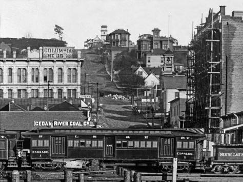
Nearly the same prospect looking north on Second from between Cherry and Columbia Streets, although recorded a quarter-century later during the 1912 Golden Potlatch Celebraton.
The alert Ron Edge discovered it while helping the Museum of History and Industry scan some of its oldest prints. The print of Judkins’ line-up of primary school children – about 200 of them on the east side of Second Avenue filling the block between Columbia and Marion Streets, and more – is dated June 23, 1886.
Handwriting on the back makes a claim for Emma Blocksom. It is her “school picture” and Emma is probably one of the posing 200 or so. The Blocksoms are listed once in the 1886 city directory, below, living on Washington Street. The promising family lead stops there. (And for us, now, as well.)
Seattle opened Central School in 1883 four blocks up First Hill from here. Central School was big enough to handle as many scholars, and more, as those lined up. Perhaps this late June day is the last before summer vacation for these students, and taking one school picture is certainly more efficient than several. (In 1886 Seattle’s population of school-age citizens between four and twenty-one years old was 2,591.)
Central School, the impressive white box with a tower seen here, sat on the south side of Madison Street, between Sixth and Seventh avenues. This view of it was recorded ca. 1886 from near the corner of Ninth Avenue and Columbia Street. It shows how to the east of 6th Avenue First Hill nearly leveled off, pausing in its climb. Later in the 1960s this interruption became a more convenient topography for building the Seattle Freeway [Interstate-5).Central School looking north from near Mill Street (Yesler Way) in the mid-1880s. Apparent here, again, is the pause in First Hill’s climb east of Sixth Avenue. Seventh Avenue is on the right.
What is not explained for either of these pros is how did they lift or carry their heavy cameras so high above the boardwalk? Here I am again thankful for help from Ron Edge. In the MOHAI collection off older prints, Ron found an 1887 panoramic look from Denny Hill that includes an unobstructed sighting down Second Avenue. While it is soft on focus, it still shows many of the landmarks included here. Most importantly, the leafy tree near the northwest corner of Second and Columbia, on the left in both of the featured photos, is standing in the panorama, a welcomed help for our ‘hide-and-seek’ after the photographer’s prospect. About a third-of-a-block south of Columbia Street a two-story residence stands at the curb and over the sidewalk that uniquely runs below it. The residence, we suspect, was constructed before Second Avenue was developed from a path into a street. Most likely both photographers were invited by this neighbor to shoot their parades from the this second floor veranda.
BEST IF YOU ENLARGE THIS NOW. Putting our heads and pictures together, Ron Edge and I have found what we think – but cannot yet prove — is the likely perch for the two photographers. It is, as noted in the text, a few yards south of Columbia Street on the west side of Second Avenue. The young tree that stands here above the center of the photograph is on the west side of Second Avenue and to the left of the two story clapboard that shines brilliantly in the late afternoon sun sometime in 1886. It is the same tree that shows next to the sidewalk at the left border of the Judkins photograph, second down from the top. Now you best pay attention. Under the tree and a few yards beyond it up the west side of Second Avenue is a shadow caste by a structure which is not seen except for two well-lighted (by the same sun) posts. We hope to determine later if these support a balcony over the sidewalk or an enclosed second floor in the here otherwise hidden structure. It is from there, we suggest and nearly believe, that the two photographers took their two similarly elevated recordings of Second Avenue north of Columbia Street. This detail was pulled from a panorama taken from Denny Hill and reveals much else including the Plymouth Congregation Church steeple, which appears in both of the neighbors’ photographs on the east (left) side of Second Avenue. The large ornamented structure beyond and to the right of our intersection is the Occidental Hotel before its 1887 additions. When destroyed by the city’s Great Fire of 1889 the hotel (its rubble) filled the flatiron block of Mill Street (Yesler Way), James Street, Second Avenue and Pioneer Place.