Seattle Now & Then: Marion Street Looking East through Western Ave, ca 1905

(click to enlarge photos)

THEN: Looking east on a Marion Street showing several delivery wagons with their often affectionately matched teams of horse power. (Courtesy, Museum of History and Industry)
NOW: The red brick tile-trimmed Federal Building, left-of-center, dates from the early depression. That its design was awarded to James A. Wetmore, a resident of the “other Washington,” did not please the many Seattle architects who were increasingly in need of work at the beginning of the Great Depression.

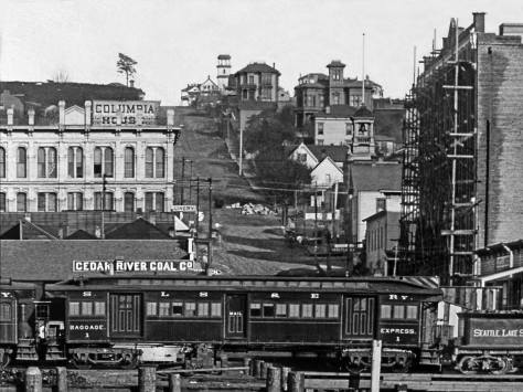
It took the greater part of Jean Sherrard’s 20-plus-foot extension pole to lift his camera pointing east on Marion Street from the prospect the Webster and Stevens Studio photographer used to record this week’s featured “then.”  We figure that it dates from 1905 or 1906. The top four floors of the Colman Building, the six-story brick block, right-of-center, were completed in 1905.  Facing First Avenue, the Colman survives, extending the full block between Marion and Columbia Streets.

CLICK to ENLARGE

It was James Colman, one of Seattle best-known pioneers not named Denny, who built his namesake landmark.  The brilliant engineer and Scottish immigrant is also honored with a park on Lake Washington Boulevard and Colman Dock, the long wharf that has been the center for Puget Sound transportation since the late nineteenth century.  The Dock is directly behind and over the right shoulder of the photographer of the featured photo at the top.  Here the nine tracks of Railroad Avenue separated the Colman Dock and the West Seattle Ferry Dock from the photographer and the bustling business of Marion Street.

The many tracks on Railroad Avenue in 1912 during that year’s Golden Potlatch celebration. Fire Station No. 5 at the foot of Madison Street, is left of center (with the tower).
CLICK TO ENLARGE (This montage was pulled from the Illustrated History of the Seattle Waterfront, which can be viewed on this blog.    But you must search the “buttons” to find it.)

The four-story stone building on the right (of the featured photo at the top) , the Colman Annex, is separated from the Colman Building by Post Avenue, which on some old city maps is called a street and on others an alley.  This “Colman Annex” was constructed of east coast stone. It was a lucky break for Colman: when the federal postmaster rejected its delivery – the stone was decreed as too soft for the construction of Seattle’s main post office at Third Avenue

The Collman Bldg is far left and the darker mass left-of-center is the Colman Annex. The photo looks west from First Avenue.  CLICK TO ENLARGE

and Union Street – Colman purchased the lot for pennies on the dollar. Many locals will best remember it as the long-time home for Society Candies.  More recently a parking lot, the Colman Annex block is now filled by a glass curtain high-rise that celebrates its location as The Post Building. It can be glimpsed through the leaves, upper-right, in Jean’s repeat.

The COLMAN ANNEX is on the left. View looks west from Post Alley.

The wagons, above and in the featured photo at the top,  most likely have something to do with the delivery of produce. This is the Commission District developed near both the railroads and the “mosquito fleet” steamers that carried fresh fruits and vegetables to the district’s large and generally homely warehouses.  They were run by middle-men who were best known as “the sharks” by both the farmers who sold to them and grocers who bought from them.  This was the gouging “Western Avenue combine” that truck farmers, home-owners and a progressive city council soon opposed in 1907 with a go-around, the Pike Place Public Market.

CLIP to ENLARGE

WEB EXTRAS

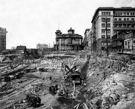
I was shooting on the waterfront for the column yesterday and came across a couple of scenes I can never get enough of. For your enjoyment, here they are:

(Thanks for your spontaneous/impetuous caress of this city Jean – in the right places.)

Anything to add, guys?   Surely Jean.

THEN: Arthur Denny named both Marion and James Streets for his invalid brother, James Marion Denny, who was too ill to accompany the “Denny Party” from Oregon to Puget Sound in 1851. (Courtesy, Gary Gaffner)

Then: Looking north from Pioneer Place (square) into the uptown of what was easily the largest town in Washington Territory. This is judged by the 3218 votes cast in the November election of 1884, about one fourth of them by the newly but temporarily enfranchised women.Tacoma, in spite of being then into its second year as the terminus for the transcontinental Northern Pacific Railroad, cast 1663 votes, which took third place behind Walla Walla's 1950 registered votes.

THEN: The Moose float heads south on First Avenue at Columbia Street during the 1912 Potlatch parade of fraternal and secret societies. Behind them are Julius Redelsheimer's clothing store and the National Hotel, where daily room rates ran from 50 cents to a dollar.

native-basket-seller-then-mr

THEN: Through its two decades — 1892 to 1913 — at the northeast corner of Cherry Street and Third Avenue, the Seattle Theatre was one of the classiest Seattle venues for legitimate theater as well as variety/vaudeville

THEN:In late 1855 the citizens of Seattle with help from the crew of the Navy sloop-of-war Decatur built a blockhouse on the knoll that was then still at the waterfront foot of Cherry Street. The sloop’s physician John Y. Taylor drew this earliest rendering of the log construction. (Courtesy, Yale University, Beinecke Library)

THEN: The city's regrading forces reached Sixth Avenue and Marion Street in 1914. A municipal photographer recorded this view on June 24. Soon after, the two structures left high here were lowered to the street. (Courtesy, Seattle Municipal Archives)

THEN: Frank Shaw’s late winter composition of waterfront landmarks at the foot of Madison Street in 1963. (Photo by Frank Shaw)

THEN: This post-1889 waterfront block of sheds and ships was replaced in 1911 by the Grand Trunk Pacific Dock, described at the time as “the largest wooden finger pier in North America.” The exception was Fire Station No. 5 on the left at the foot of Madison Street. A brick station replaced it in 1913. (Museum of History & Industry)

THEN: In this 1887 look up Columbia Street from the waterfront is the bell tower of the fire station, tucked into the hill on the right. It would soon fail to halt the city’s Great Fire of June 6, 1889. The station and everything between it and Elliott Bay were reduced to ashes, smoldering bricks and offshore pilings shortened like cigars. (courtesy, Kurt Jackson)

THEN: Looking north from Columbia Street over the construction pit for the Central Building. On the left is a rough section of the Third Avenue Regrade in the spring of 1907. (Courtesy, MOHAI)

THEN: The driver, lower left, leads his team towards First Avenue up a planked incline on Madison Street. (Courtesy MOHAI)

THEN: Looking south on First Avenue from its northwest corner with Madison Street, circa 1905. (Courtesy Museum of History and Industry)

THEN: Depression-era protestors climb Columbia Street sidewalk along-aside Seattle architect Harlan Thomas’s elegant Seattle landmark that opened in 1925 as home to the by then already forty-three year old Seattle Chamber of Commerce. (Courtesy, Museum of History and Industry)

THEN:

THEN: During the few years of the Klondike Gold Rush, the streets of Seattle’s business district were crowded with outfitters selling well-packed foods and gear to thousands of traveling men heading north to strike it rich – they imagined. (Courtesy, Museum of History and Industry)

THEN: The west side of Second Avenue between Columbia and Marion Streets was typical of the commercial district that was quick to develop after the city’s Great Fire of 1889. (Courtesy, Museum of History and Industry)

THEN: The Big Snow of 1916 trims two jewelers’ clocks on the west side of Second Avenue, north of Marion Street. (Courtesy, Lawton Gowey)

=====

=====

=====

=====

=====

=====

=====

=====

=====

=====

=====

=====

=====

You can find this steeple in the featured photo at the top.

=====

2 thoughts on “Seattle Now & Then: Marion Street Looking East through Western Ave, ca 1905”

  1. Paul: In the print copy version of this latest view of the Colman Annex etc you refer to “Society Candies” as a tenant. More correctly, as you stated in your 2015 view of this same intersection, it was Societe (with a diacrit). My lovely Swedish great aunt Esther (Lundgren) Williams worked there and as a child visiting the Big House in Eagledale, I would avail myself of the hard candies she brought home from work, and when entering Seattle on the pedestrian bridge from the Bainbridge ferries at Colman Dock the first smell that hit me was the unique burnt sugar odor of the candy factory. Madeleines of my youth! I can taste them still…

Leave a Reply

This site uses Akismet to reduce spam. Learn how your comment data is processed.