
(click to enlarge photos)

(Published in Seattle Times online on May 9, 2019,
and in print on May 12, 2019)
Bolstering a booming city by transforming its landscape
By Clay Eals
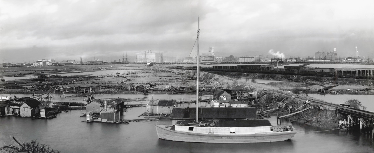
For those who may doubt the potential for documentary photography to enter the realm of art, we submit this stunning panorama, looking north toward downtown Seattle in 1916.
Elements of this are expressive, ephemeral, even ethereal. This is in part because two beloved and glowing touchstones of our past – the Smith Tower (far right, completed in 1914 and for decades fondly known as the tallest building west of the Mississippi) and Sears Roebuck Tower (second from right, completed in 1915, becoming the Starbucks Center in 1997) – take a backseat to Seattle’s rapidly evolving industrial backbone on the splayed flats of the lower Duwamish River. It’s a plain that we now call SoDo.
We see no people, but evidence of their existence abounds. The chief subject, barely afloat in the foreground, is a small, sturdy freight boat, which the Webster & Stevens photographer may have showcased to symbolize an even earlier time when seafaring was the primary mode of commerce and connection for a city defined by its water.
Today maritime remains a robust force, competing and collaborating with cars and trucks, trains and planes. But here the lonely vessel stands nearly marooned by the ebbing of the tides and the flow of profiteering that sought to bolster the booming city by transforming its landscape.
What was once a mass of muddy marsh from West Seattle to Beacon Hill was being relentlessly filled in, starting 20 years prior, with the remains of the downtown regrades as well as from the straightening, widening and deepening of Seattle’s only river (named for its native Duwamish tribe) and the creation of Harbor Island. Thus was the city’s typical cloud cover increasingly mixed with plumes of pollution.
Affirmation of this industrial bustle is embodied here by Northern Pacific tracks – one full of cars, the other full of weeds – entering from the southeast, with some tracks curving right (north) to the Stetson & Post lumber mill, marked by sprays of white smoke. The mill had its beginnings in 1874 and relocated from Dearborn Street in 1915 to its East Waterway site. Moving left (west), we also see two massive freight-storage terminals at Hanford and Lander streets.
Moving farther west in this spectacular vista, we see the busy Barton & Company, packer and distributor of “Circle W” mutton, lamb, ham, bacon and byproducts (slogan: “Eat Less, but Eat the Best”).
So why is this ex-swamp called SoDo? The contentious origin, hilariously detailed in Dan Raley’s fine 2010 history book “Tideflats to Tomorrow,” boiled down to geography. It means South of the Dome. What dome? The short-lived Kingdome (1976-2000), on the site of today’s CenturyLink Field. Did we say ephemeral?
WEB EXTRAS
For even more great history, check out our Seattle Now & Then 360 version of the column!
Anything to add, salty dogs?
Absolutely! Here, in chronological order, are seven clippings from the Seattle Times online archive (available via Seattle Public Library) that were helpful in the preparation of this column. Click on any clipping to enlarge it. –Clay


