THEN1: Dating between 1938 and the mid-1940s, this postcard is a pre-Photoshop consolidation of two photos of Mack’s Totem Curio Shop, elevated above street level at 71 Marion Street Viaduct. In its first few years, Mack’s was a few doors west at 63-1/2. Be sure to click this photo twice to see the mismatch at bottom center. (Courtesy Dan Kerlee)THEN2: Albert Angus “Mack” McKillop stands at the entry to his shop, which bears a slightly different name, likely at 63-1/2 Marion Street Viaduct in the mid-1930s. (Courtesy Victoria McKillop)NOW: Wearing an ivory pendant made by her grandfather, Victoria McKillop of Ballard stands on the Marion Street Viaduct where her grandfather operated Mack’s Totem Curio Shop from 1933 to 1971. The viaduct was truncated during the 2019 demolition of the Alaskan Way Viaduct. Pedestrians now walk between First Avenue and Colman Dock along a new elevated walkway that doglegs via Columbia Street. (Clay Eals)
(Published in the Seattle Times online on Oct. 29, 2020
and in PacificNW Magazine of the print Times on Nov. 1, 2020)
Totem-shop postcard turns the corner on a curious puzzle
By Clay Eals
With this week’s “Then” photo, we present a visual puzzle whose clue is quite difficult to detect.
The subject is Mack’s Totem Curio Shop. Most Seattleites today associate the word “curio” with Ye Olde Curiosity Shop, for 121 years a tourist fixture with ghoulish attractions at several spots near or along the downtown waterfront, now at Pier 54.
But not much farther than a mummy’s throw away, Albert Angus “Mack” McKillop competed with Ye Olde for 38 years, from his store’s inception in 1933 to his death in 1971. His wares ranged from Native American carvings and Belfast cord (used in macramé) to fossils and walrus ivory (whose sale came under federal regulation in 1972).
Mack’s operated from the Marion Street Viaduct, a second-story bridge guiding countless pedestrians from First Avenue across Alaskan Way to the Colman Dock ferries and vice versa. Talk about storefront visibility.
That’s where the puzzle comes in. With carved panels, totem poles and bauble-filled windows, the shop stood near the middle of the elevated block. So why does this postcard depict Mack’s on a corner?
A detail of the mismatch in our “Then.” (Courtesy Ron Edge)
Our sleuths strained for clues by studying old maps, aerial photos and window reflections. Finally, Ron Edge enlarged the card to reveal that the lower bricks of the depicted corner do not exactly line up. Thus, discounting potentially poor masonry, we assume the card is a mash-up of two images, one facing east and the other facing south, to create a faux angle.
The postcard is among artifacts preserved by the family. Did McKillop create and sell the fabricated portrayal for his shop to be perceived as more conspicuous and prosperous? Did he assume newcomers, conned by the card, would forgive the deception upon their arrival? The answers remain … a curiosity.
Born in Manitoba in 1896, McKillop spent early adult years as a schooner seaman near Point Barrow, Alaska, before heading south at age 37 to start his Seattle business. His carved ivory gavels, earrings and belt buckles became a specialty.
His most celebrated showpiece, glaring from high on an interior wall, was a walrus head with four tusks. In 1956, McKillop told The Seattle Times he had found the rare remnant in a local tavern. His research indicated the animal was shot in 1915 in Siberia, and he claimed it was the world’s only known four-tusker.
McKillop was both craftsman and salesman. So one can wonder at the monogram — a mix of his A and M initials — visible at the base of the totem poles appearing at each end of the postcard. Did Mack commission or acquire the poles or carve them himself? Another unsolved puzzle!
WEB EXTRAS
To see Jean Sherrard‘s 360-degree video of the “Now” prospect and compare it with the “Then” photo, and to hear this column read aloud by Clay Eals, check out our Seattle Now & Then 360 version of the column!
Big thanks to Dan Kerlee, Ron Edge, Barbara Manning and especially Victoria McKillop for their invaluable help in assembling the elements and thrust of this column!
Below are 55 supplemental photos, a map, an email message, four certificates and, in chronological order, 43 historical clippings from The Seattle Times online archive (available via Seattle Public Library) and other online newspaper sources that relate to Mack’s Totem Curio Shop, A.A. McKillop and the Marion Street Viaduct and that were helpful in the preparation of this column.
A detail of the mismatch in our “Then.” (Courtesy Ron Edge)1905, site of future Marion Street Viaduct, looking west on Marion Street. (Courtesy Ron Edge)Pre-1930s Marion Street Viaduct, looking west. (Courtesy Ron Edge)Nov. 29, 1951, Mack’s Totem Curio Shop along the Marion Street Viaduct, looking west. (Seattle Municipal Archives)1950 Sanborn map address numbers for Marion Street Viaduct (north is up). (Courtesy Ron Edge)A.A. McKillop and son John (Courtesy Victoria McKillop)April 1, 1931, A.A. McKillop seaman’s application. (Courtesy Barbara Manning)Undated A.A. McKillop registration. (Courtesy Victoria McKillop)April 2, 1931, A.A. McKillop seaman’s protection certificate. (Courtesy Victoria McKillop)July 27, 1939, A.A. McKillop marriage registration, Victoria, B.C. (Courtesy Barbara Manning)1934 McKillop listing in city directory. (Courtesy Barbara Manning, Ron Edge)Undated, Albert Angus McKillop at his counter. (Courtesy Victoria McKillop)Undated, Albert Angus McKillop at desk with ivory. (Courtesy Victoria McKillop)Undated, Albert Angus McKillop outside shop with bird totem. (Courtesy Victoria McKillop)Undated, A.A. McKillop at shop entry. (Courtesy Victoria McKillop)1954 Mack’s Totem Curio Shop looking east. (Courtesy Seattle Public Library)Undated, Mack’s Totem Curio Shop looking east. (Courtesy Victoria McKillop)Undated, Mack’s Totem Curio Shop looking east. (Courtesy Victoria McKillop)Undated, Mack’s Totem Curio Shop looking east. (Courtesy Victoria McKillop)Undated, Mack’s Totem Curio Shop looking east. (Courtesy Victoria McKillop)Undated, Mack’s Totem Curio Shop looking south. (Courtesy Victoria McKillop)Undated, Mack’s Totem Curio Shop looking south. (Courtesy Victoria McKillop)Undated, Mack’s Totem Curio Shop looking south. (Courtesy Victoria McKillop)Undated, seven masks at Mack’s exterior. (Courtesy Victoria McKillop)Undated, totem outside Mack’s. (Courtesy Victoria McKillop)Undated, totem outside Mack’s. (Courtesy Victoria McKillop)Undated, totem outside Mack’s. (Courtesy Victoria McKillop)Undated, totem outside Mack’s. (Courtesy Victoria McKillop)Undated, totem outside Mack’s. (Courtesy Victoria McKillop)Undated, totem outside Mack’s. (Courtesy Victoria McKillop)Undated, totem outside Mack’s. (Courtesy Victoria McKillop)Undated, totem outside Mack’s. (Courtesy Victoria McKillop)Undated, totem outside Mack’s. (Courtesy Victoria McKillop)Undated, totem outside Mack’s. (Courtesy Victoria McKillop)Undated, totem outside Mack’s. (Courtesy Victoria McKillop)Undated, totem outside Mack’s. (Courtesy Victoria McKillop)Undated, totem outside Mack’s. (Courtesy Victoria McKillop)Undated, totem outside Mack’s. (Courtesy Victoria McKillop)Undated, masks outside Mack’s. (Courtesy Victoria McKillop)Undated, inside Mack’s. (Courtesy Victoria McKillop)Undated, inside Mack’s. (Courtesy Victoria McKillop)Undated, inside Mack’s. (Courtesy Victoria McKillop)Undated, four-tusk walrus inside Mack’s. (Courtesy Victoria McKillop)Undated, four-tusk walrus postcard. (Courtesy Victoria McKillop)Undated, Mack’s panel detail. (Clay Eals)Undated, Mack’s panel detail. (Clay Eals)Undated, Mack’s panel detail. (Clay Eals)Undated, Mack’s panel detail. (Clay Eals)Undated, Victoria McKillop with Mack’s panel. (Clay Eals)Undated, Mack’s panel. (Clay Eals)Undated, Mack’s panel detail. (Clay Eals)Undated, Mack’s panel detail. (Clay Eals)Undated, Mack’s panel detail. (Clay Eals)Undated, Mack’s panel. (Clay Eals)Undated, Mack’s panel. (Clay Eals)Undated, Mack’s panel. (Clay Eals)Mack’s two-tusk walrus head. (Clay Eals)Andrew Angus “Mack” McKillop signature on letter to wife. (Courtesy Victoria McKillop)Email message, Nov. 9, 2020, by Selene Higgins, niece of A.A. “Mack” McKillop.“Mack” McKillop’s wife Carmen as a child. (Courtesy Selene Higgins)The McKillop house on Bainbridge Island. (Courtesy Selene Higgins)March 10, 1909, Seattle Post-Intelligencer, page 13.March 11, 1909, Seattle Post-Intelligencer, page 6.July 3, 1909, Seattle Post-Intelligencer, page 12.Oct. 17, 1909, Seattle Post-Intelligencer, page 25.Dec. 18, 1910, Seattle Post-Intelligencer, page 22.Oct. 27, 1910, Seattle Times, page 76.Oct. 18, 1911, Seattle Post-Intelligencer, page 7.April 10, 1914, Seattle Post-Intelligencer, page 14.Nov. 17, 1914, Seattle Times, page 17.July 20, 1916, Seattle Post-Intelligencer, page 2.Oct. 7, 1916, Seattle Post-Intelligencer, page 4.March 4, 1917, Seattle Post-Intelligencer, page 10.Sept. 30, 1917, Seattle Post-Intelligencer, page 30.Oct. 6, 1918, Seattle Post-Intelligencer, page 9.Nov. 3, 1918, Seattle Post-Intelligencer, page 30.Dec. 8, 1918, Seattle Post-Intelligencer, page 39.Jan. 1, 1920, Seattle Post-Intelligencer, page 17.April 24, 1920, Seattle Post-Intelligencer, page 22.June 9, 1921, Seattle Times, page 20.Dec. 5, 1923, Seattle Post-Intelligencer, page 5.Sept. 10, 1939, Seattle Times, page 25.Aug. 7, 1940, Seattle Post-Intelligencer, page 19.June 7, 1942, Seattle Times, page 24.Sept. 6, 1943, Seattle Times, page 17.Nov. 24, 1947, Seattle Post-Intelligencer, page 16.Oct. 30, 1949, Seattle Times, page 23.June 22, 1955, Seattle Times, page 31.Dec. 30, 1955, Seattle Post-Intelligencer, page 23.March 6, 1956, Seattle Times, page 26.May 6, 1956, Seattle Times, page 115.Oct. 20, 1959, Seattle Times, page 23.
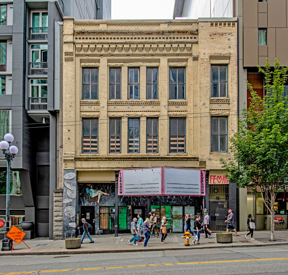
THEN1: Workers at C. Sidney Shepard & Co. assemble for a portrait in March 1904. The windows reflect the block-long Arcade Building directly across First Avenue, where the Seattle Art Museum stands today. (Courtesy, Ron Edge)THEN2: To mark the Lusty Lady’s last day on June 12, 2010, dancers – from left, Hexe, Wildflower, Isis, Heather and Tonya – gather at the entrance. For more of the story, visit photographer Erika Langley’s website at http://www.erikalangley.com. (Erika Langley)NOW: The Post Edwards building has been unoccupied since the 2010 closing of the Lusty Lady, though the interior has been gutted for eventual renovation. Two modern towers, the 25-story Harbor Steps Apartments and the Four Seasons Hotel, muscle in on either side. (Jean Sherrard)
(Published in the Seattle Times online on Oct. 22, 2020
and in PacificNW Magazine of the print Times on Oct. 25, 2020)
This classic masonry building met a lot of peeps along ‘Flesh Avenue’
By Jean Sherrard
This week’s “Then” photo features an amiable bunch of C. Sidney Shepard Co. employees who might have enjoyed a bit of wordplay if given a chance. Their short-lived wholesale metal shop operated between University and Union streets on the west side of First Avenue.
Mirrored reflections in the shop windows date the image. A billboard across the street promotes Denman Thompson’s touring production of “The Old Homestead” for March 17-19, 1904. Though the hit play tempted audiences for years to come, Shepard’s shop ended its run at the Post Edwards Building in 1906.
The Post Edwards (aka the Hotel Vendome) arose in the boom one year after the 1889 Great Seattle Fire. Prolific architect William E. Boone (descendant of Daniel of the legendary raccoon-skin cap) adopted the then-popular Romanesque Revival style. For torched Seattle, the fireproof masonry stonework offered a sense of security that wood could not.
The Hotel Vendome (“Commercial and Family Patronage specially solicited”) promoted itself as a respectable alternative to sketchier lodging on First Avenue, though itinerant psychics, mediums and spiritualists prowled its lower floors for decades. Madame Melbourne and Venus the Gypsy (who promised “satisfaction or no fee”) read the palms of Yukon-bound gold seekers, while the Rev. Edward Earle (“world’s greatest psychic”) foretold the fortunes of soldiers headed into what then was called the Great War.
By the mid-1940s, Anne and Lucius Avery had bought Post Edwards, rechristening it the Seven Seas Hotel and Tavern. Upon her death in 1969, “Mom” Avery was feted for her fondness for seafarers and skills as a bouncer, but the increasingly gritty street had filled with strip shows, porn and pawn shops, cementing its reputation as “Flesh Avenue.”
So when the Lusty Lady, the peep show with a famously punny marquee, arrived at the Post Edwards in 1985, it seemed to suit the neighborhood. Uniquely, however, the venue was run by women, and it was there, in 1992, that young photographer Erika Langley found a gutsy and radical project.
To tell the real story of the place, manager June Cade urged her to sign on as a dancer. Shy and terrified, Langley nevertheless agreed and never looked back. Her 1997 book “The Lusty Lady” was the celebrated result.
After publication, Langley continued dancing until 2004. “I learned so much about humans and sexuality and judgment,” she says, “and in this unlikely place, I had found my tribe.”
Since the 2010 closure of the Lusty Lady, the Post Edwards has drooped with inactivity. As the marquee might say, the building needs more than a sheet to test its metal.
WEB EXTRAS
First, most definitely visit ErikaLangley.com. She’s an amazing photographer with a genius for both image and storytelling.
To see our 360 video taken along First Avenue, and hear Jean’s accompanying narration, dance on over here.
THEN: This property-value assessor’s photo, looking west and slightly north from the intersection of Seventh Avenue and Lenora Street north of downtown, was taken Dec. 18, 1957. Car details from our automotive informant Bob Carney: (from left) on street 1953 Chevrolet, 1956 Buick Special and 1953 Chevrolet 210 sedan. To left of Lee Moran building: 1953 Chevrolet. To right of building: 1955 Mercury. The lineup of used cars facing the street: 1956 Lincoln, 1956 Mercury, 1954 Mercury, 1956 Mercury, 1955 Oldsmobile 88, 1955 Studebaker coupe, 1950 Buick (can barely see the portholes) and, at far right, 1957 Ford. (Puget Sound Regional Branch, Washington State Archives)NOW: Opened Jan. 30, 2018, the Amazon Spheres complex serves as the signature structure for the internet-based colossus. Standing three to four stories tall, the spheres mix 40,000 plants with meeting spaces and stores, but the orbs are closed during the coronavirus pandemic. (Jean Sherrard)
(Published in the Seattle Times online on Oct. 15, 2020
and in PacificNW Magazine of the print Times on Oct. 18, 2020)
Who could have predicted what these car lots would become?
By Clay Eals
Will Ferrell is mortally worried. Using the phrase “little did he know,” a stranger’s voice in his head is foretelling his death. He consults a literature professor, Dustin Hoffman, who warms to the puzzle by saying that he “once gave an entire seminar on ‘little did he know’ .”
Dustin Hoffman (left) and Will Ferrell in the 2006 film “Stranger Than Fiction.”
We jump from that scene in the 2006 film “Stranger than Fiction” (left) to our “Then” photo from Dec. 18, 1957. It captures a gent in a fedora driving a 1956 Buick Special and in momentary contemplation while stopped on Seventh Avenue at Lenora Street. Little did he know — or could anyone conceive — of the transformation 60 years later of this down-to-earth commercial tableau.
A stone’s throw from post-World War II downtown, this block is a typical 1950s tribute to the internal combustion engine, featuring the Lee Moran, W.R. Smith and ABC Fair-Way businesses and their symphony of signs: from “Cash for Cars” and “Cars under Cover” to “Highest Price for Used Cars” and “All Makes All Prices.” Car dealers had covered the block since the early 1940s, preceded by rental housing back to the century’s turn.
On the day this photo was taken (for use by the county to aid in assessing property tax), the weather forecast was familiar: “mostly cloudy with a few showers, occasional sun,” with a high of 45 to 50 degrees.
Gov. Albert Rosellini was inviting Seattle and King County to lead construction of a controversial second bridge across Lake Washington. Nationally, the first Atlas intercontinental missile was launched at Cape Canaveral, Alabama voters allowed the state to abolish a county in which Blacks outnumbered whites by more than 7 to 1, and actress Elizabeth Taylor underwent an appendectomy. Internationally, NATO delegates pushed Russia to resume disarmament talks.
Dec. 18, 1957, Frederick & Nelson ad, Seattle Post-Intelligencer, page 16. (Illustration by Bob Cram.) The “ultra-chrome dome home” resembles, among other things, the legendary Kalakala ferry.
Among newspaper ads this day was one for the classy Frederick & Nelson department store (right). The pitched product was women’s stockings, but the accompanying Bob Cram illustration was a huge, pre-Jetsons cartoon featuring a “man of tomorrow” having landed in a space vehicle and his wife dashing to greet him — in “Round-the-Clock superb sheers” — at the front door of their “ultra-chrome dome home.”
One might say that the many round-topped sedans in our “Then” photo serve as figurative domes, each one a sphere to represent the life of a driver or family.
Today we find the block dominated by the triple-orb greenhouse of Seattle-based Amazon. The online giant is doing everything it can — including, most recently, dabbling in drone delivery — to encompass all of us in its shopping sphere.
Where will that lead? Little do we know.
WEB EXTRAS
To see Jean Sherrard‘s 360-degree video of the “Now” prospect and compare it with the “Then” photo, and to hear this column read aloud by Clay Eals, check out our Seattle Now & Then 360 version of the column!
Below are three supplemental photos and, in chronological order, 21 historical clippings from The Seattle Times online archive (available via Seattle Public Library) and other online newspaper sources that were helpful in the preparation of this column.
Sept. 29, 1943, tax assessor’s photo of the same site as our “then” but taken from Sixth Avenue at the address 2016 Sixth Ave. Car details from our automotive informant Bob Carney: (from left) 1934 Studebaker, 1940 Plymouth, 1939 Ford Standard, and 1930 Studebaker Dictator. (Puget Sound Regional Branch, Washington State Archives)Dec. 18, 1957, tax assessor’s photo of the same site as our “then” but taken from Sixth Avenue at the address 2016 Sixth Ave. Car details from our automotive informant Bob Carney: (from left) 1956 Ford Fairlane, 1954 Chevrolet 210 station wagon, 1951 Nash and 1956 Chevrolet Bel Air. (Puget Sound Regional Branch, Washington State Archives)Sept. 8, 2020, Amazon Spheres, facing east from Sixth Avenue. (Jean Sherrard)May 31, 1903, Seattle Times, page 26.June 12, 1904, Seattle Times, page 13.June 3, 1910, Seattle Times, page 23.April 30, 1911, Seattle Times, page 39.July 9, 1911, Seattle Times, page 22.Oct. 5, 1913, Seattle Times, page 43.Dec. 14, 1913, Seattle Times, page 38.March 1, 1914, Seattle Times, page 43.Sept. 2, 1926, Seattle Times, page 27.Sept. 3, 1926, Seattle Times, page 29.Feb. 1, 1944, Seattle Times, page 19.Sept. 3, 1948, Seattle Times, page 35.May 19, 1954, Seattle Times, page 48.Feb. 25, 1955, Seattle Times, page 39.May 19, 1957, Seattle Times, page 56.Dec. 17, 1957, Seattle Post-Intelligencer, page 28.Dec. 18, 1957, Seattle Post-Intelligencer, page 11.Dec. 18, 1957, Frederick & Nelson ad, Seattle Post-Intelligencer, page 16. (Illustration by Bob Cram.)Dec. 18, 1957, Seattle Post-Intelligencer, page 17. (Illustration by Bob Cram.)Dec. 18, 1957, Seattle Post-Intelligencer, page 27.Dec. 19, 1957, Seattle Post-Intelligencer, page 40.
THEN: Three years before the creation of the Pike Place Market in 1907, an unknown photographer captured savory treats. Just right of the tunnel entrance, a temporary assembly line supplied rivers of concrete to line the tunnel walls. Meanwhile, at upper left, an intrepid gent peers over the precipitous edge of the retaining wall at the laborers below.NOW: A northbound Burlington Northern train emerges from the still-vital north portal onto a waterfront under construction. Concrete pillars and beams are being poured to support a new road connecting the waterfront to Belltown, the four-lane Elliott Way.
(Published in the Seattle Times online on Oct. 8, 2020
and in PacificNW Magazine of the print Times on Oct. 11, 2020)
The tunnel that reshaped the waterfront (no, not THAT one) by Jean Sherrard
Just over a year and half has passed since the ribbon-cutting ceremony opening the 1.7-mile Highway 99 tunnel that replaced the geriatric Alaskan Way Viaduct. Four years of burrowing with Bertha, one of the world’s largest tunnel borers, followed by two years of construction and months of viaduct demolition, left behind a wide-open waterfront, ripe for re-imagining.
That most ambitious of Seattle tunnels invites comparison with another one completed 115 years ago. It, too, was an attempt to solve a waterfront problem. Alaskan Way, originally Railroad Avenue, was ribbed with a wide swath of eight sets of parallel train tracks. The dangerous clatter and din of passing trains separated the upland city from its vigorous bay.
Seattle’s transformational city engineer, Reginald H. Thomson, devised the re-routing of some of that traffic, convincing James J. Hill, the Great Northern railroad magnate, to send his trains through a 5,141.5-foot tunnel from the waterfront to the proposed King Street train station (built in 1906 as a marble temple of transport suitable for the aspiring young city).
On April Fools Day 1903, construction commenced at the tunnel’s northern portal, employing pressure hoses to wash away vast tons of dirt and expose the face of the hillside. Within two months, work began a mile away on the south portal.
Hundreds of men at both ends dug day and night for two years in a fiercely competitive race to the middle. In a marvel of precision engineering, the two boreholes were only a fraction of an inch off when in October 1904 they met. Wags among the workers joked that they had built the longest tunnel in the world: from Virginia to Washington — streets, that is. And for its time, the tunnel did break records. When completed, it was the highest (25.8 feet) and widest (30 feet) tunnel in the world.
The tube was lined with 3-1/2 to 4-1/2 feet of concrete, reaching its deepest point 111 feet below Fourth and Spring. Curiously, it also delved through remains of an anaerobically preserved primeval forest at Fourth and Marion. (Soon after exposure to air, the trees reportedly turned to mulch.)
Though overhead property owners worried about their buildings’ foundations, the only actual casualty of construction was the Hotel York at the northwest corner of First and Pike (in our “Then” photo sporting an enormous mural puffing up Owl cigars). Its underpinning undermined, it was razed in November 1904. In 1912, it was replaced by the Corner Market Building, which to this day anchors the Pike Place Market.
WEB EXTRAS
To watch our 360 degree video, which includes two passing trains and Jean’s narration, click here.
Plus a bit of a backstory here. I found a lovely ‘then’ and tried to repeat it, only to discover that the quality was subpar. The original is not lost, but included in the many thousands that Paul donated to the SPL; so for the time being, unavailable. Here, then, is my first attempt at repeating the shot from below:
Alternate THEN: North portal under construction from belowMy alternate NOWMore from below. Girders lined up for the new Elliott Way. Victor Steinbrueck Park above…
And, in no particular order, shots of construction and trains!
Construction, double decker train cars and a receding ferry. Who could ask for anything more?
THEN: This nighttime view of the eastbound Mount Baker tunnel shows that the original twin tubes had two lanes apiece. The photo was taken at least a few weeks after the tunnel’s July 2, 1940, opening because the 3-foot wide interior sidewalks, with high curbs and pipe guardrail, were not installed until later that month. (University of Washington Libraries, Special Collections, TRA1001)NOW: Repeating the original path of our “Then,” this daytime view shows only two of the Mount Baker tunnel’s four present-day eastbound lanes for auto traffic. The other two, not pictured, emerge from the formerly westbound tunnel immediately to the north. (Jean Sherrard)
(Published in the Seattle Times online on Oct. 1, 2020
and in PacificNW Magazine of the print Times on Oct. 4, 2020)
In 1940, tunnel vision created a connection to the Eastside
By Clay Eals
As spooky as it is ethereal, our “Then” photo suggests Seattle barreling through a spacey cylinder to meet the future. The scene typifies our city’s bent for transforming its topography to satisfy urban dreams.
Eighty years ago, on July 2, 1940, an audacious dream — twin tunnels drilled through Mount Baker Ridge to connect Seattle to Mercer Island and the greater Eastside via an innovative bridge with floating concrete pontoons that crossed Lake Washington — became a reality that countless motorists take for granted today.
From the outset, the inextricably linked tunnels and bridge personified popularity, drawing 11,611 vehicles in the first 10-1/2 hours alone. To sustain this full-to-bursting stretch of what became an interstate artery, a companion tunnel and span were added a half-century later while, astonishingly, the original bridge sank and was quickly rebuilt.
Time was, Seattleites traveled east only by ferrying across or circumnavigating the elongated next-door lake. Some, including James Wood, Seattle Times associate editor, wanted to keep it that way.
“Just about the wildest dream ever to afflict an engineering mind is the proposed 8,000-foot concrete fence,” he wrote on Aug. 13, 1937. He called the tunnel-bridge project “a gross and wholly unnecessary obstruction.”
Prevailing, however, were campaigners for commerce. “The future prosperity of Seattle depends upon removing the barrier of the lake in order to gain easier access to the hinterland,” wrote Medina mogul Miller Freeman in the Jan. 9, 1938, Times. “It will providentially afford Seattle room for expansion in the only direction it can grow successfully.”
Thus the bridge and tunnels joined Seattle’s indelible identity. We of a certain age recall holding our breath through all 1,465 feet when parents drove us through one of the tunnels. Sometimes our elders humored us, generating a riotous echo by honking the car horn. But all was not childish fun.
As the neon indicates in our “Then,” when crossing the bridge to Mercer Island, drivers faced a variable toll of 25 to 45 cents, which ended in 1949. The curved arrow pointed to an abrupt “Lake Shore” entrance/exit opportunity tucked between the tunnels and bridge both east- and westbound at 35th Avenue South. A treacherous invitation to high-speed fender-benders and worse, it was curtailed in 1989.
Other tunnel-bridge idiosyncrasies, inconceivable today, triggered repeated fatalities. An awkward mid-bridge bulge to allow boat crossings was mercifully removed in 1981. Unprotected reversible lanes, instituted in 1960 to ease commuting, finally were eliminated in 1984.
Momentarily inattentive to the latter, as a fledgling 16-year-old driver in 1967 I barely avoided a head-on crash one afternoon.
The prospect still spooks me.
WEB EXTRAS
To see Jean Sherrard‘s 360-degree video of the “Now” prospect and compare it with the “Then” photo, and to hear this column read aloud by Clay Eals, check out our Seattle Now & Then 360 version of the column!
Below are seven present-day photos and, in chronological order, 62 historical clippings from The Seattle Times online archive (available via Seattle Public Library) and other online newspaper sources that were helpful in the preparation of this column. As a bonus, we’ve added a full-color cartoon map from 1940.
Traffic heads eastbound out of the two original Mount Baker tunnels on Aug. 28, 2020. Westbound traffic uses newer tunnels out of view at far right. (Clay Eals)A car emerges from the southernmost original Mount Baker tunnel, Aug. 28, 2020. The original “Portal of the North Pacific” concrete artwork is barely discernible at upper middle. (Clay Eals)Traffic crosses the Mercer Island Floating Bridge in this eastbound view from atop the Mount Baker tunnels, Aug. 28, 2020. (Clay Eals)Now a mere side street, 35th Avenue South dead-ends on the south side of the original Mount Baker tunnels, on Aug. 28, 2020. Here is where, for decades, eastbound drivers could enter the highway bridge or exit immediately after driving through the tunnel. Such access to the tunnel and bridge today is blocked and restricted to emergency vehicles. (Clay Eals)A plaque dedicating the bridge to designer Homer Hadley, Aug. 28, 2020. (Clay Eals)A plaque designating the bridge and tunnel a National Historic Civil Engineering Landmark, Aug. 28, 2020. (Clay Eals)With bridge traffic roaring in the distance, this plaque dedicates the bridge to state highway director Lacey V. Murrow, Aug. 28, 2020. (Clay Eals)Aug. 13, 1937, Seattle Times, page 6.Jan. 9, 1938, Seattle Times, page 8.May 15, 1938, Seattle Times, page 1.May 15, 1938, Seattle Times, page 4.June 26, 1938, Seattle Times, page 11.April 1, 1939, Seattle Times, page 27.Aug. 13, 1939, Seattle Times, page 42.Sept. 3, 1939, Seattle Times, page 35.Oct. 13, 1939, Seattle Times, page 16.Oct. 21, 1939, Seattle Times, page 1.Oct. 21, 1939, Seattle Times, page 2.Jan. 26, 1940, Seattle Post-Intelligencer, page 17.Feb. 5, 1940, Seattle Post-Intelligencer, page 11.Feb. 26, 1940, Seattle Post-Intelligencer, page 9.April 12, 1940, Seattle Post-Intelligencer, page 6.April 13, 1940, Seattle Post-Intelligencer, page 3.April 13, 1940, Seattle Post-Intelligencer, pages 1 and 3.May 19, 1940, Seattle Post-Intelligencer, page 27.May 31, 1940, Seattle Post-Intelligencer, page 17.June 8, 1940, Seattle Post-Intelligencer, page 9.June 14, 1940, Seattle Post-Intelligencer, page 1.June 14, 1940, Seattle Post-Intelligencer, page 3.June 14, 1940, Seattle Post-Intelligencer, page 5.June 30, 1940, Seattle Post-Intelligencer, page 1.June 30, 1940, Seattle Post-Intelligencer, page 16.June 30, 1940, Seattle Times, page 17.June 30, 1940, Seattle Times, page 19.July 3, 1940, Seattle Post-Intelligencer, page 1.July 3, 1940, Seattle Post-Intelligencer, page 6.July 3, 1940, Seattle Post-Intelligencer, page 6.July 3, 1940, Seattle Post-Intelligencer, page 7.July 4, 1940, Seattle Post-Intelligencer, page 6.July 10, 1940, Seattle Post-Intelligencer, page 10.July 21, 1940, Seattle Post-Intelligencer, page 66.Sept. 2, 1940, Seattle Post-Intelligencer, page 3.Sept. 19, 1940, Seattle Post-Intelligencer, page 9.Oct. 11, 1940, Seattle Post-Intelligencer, page 31.Cartoon map of the new floating bridge, 1940. (Randi Gustavson, Seattle Vintage)Oct. 13, 1940, Seattle Post-Intelligencer, page 58.Dec. 17, 1947, Seattle Post-Intelligencer, page 28.July 19, 1949, Southeast Missourian.Aug. 24, 1954, Seattle Times, page 4.Jan. 7, 1955, Seattle Times, page 8.May 31, 1955, Seattle Times, page 8.Feb. 3, 1957, Seattle Times, page 2.May 31, 1957, Seattle Times, page 21.Dec. 30, 1959, Seattle Times, page 17.March 16, 1960, Seattle Times, page 13.Feb. 22, 1961, Mercer Island Reporter.March 25, 1963, Seattle Times, page 5.Dec. 17, 1963, Seattle Times, page 10.Dec. 25, 1963, Seattle Times, page 67.Dec. 26, 1963, Seattle Times, page 10.Jan. 3, 1964, Seattle Times, page 10.Sept. 23, 1970, Seattle Post-Intelligencer, page 3.Jan. 17, 1974, Seattle Times, page 4.May 20, 1974, Seattle Times, page 11.Feb. 27, 1979, Seattle Times, page 12.Jan. 30, 1980, Seattle Times, page 10.Sept. 4, 1981, Seattle Times, page 98.Sept. 7, 1981, Seattle Times, page 1.April 13, 1984, Seattle Times, page 10.Aug. 16, 1984, Seattle Times, page 56.