THEN1: With an Argus 35mm camera, Bill Benshoof looked south from a ferry on the Mukilteo-Clinton run and captured Mount Rainier peeking over the mainland behind two Century 21-bannered Washington State Ferries: the Kehloken (foreground, built in 1926, sold by the state in 1975, gutted by fire in 1979 near Kirkland and sunk as an artificial reef at Possession Point on Whidbey Island) and the Rhododendron (built in 1947 and sold by the state in 2013 to Island Scallops at Qualicum Beach, British Columbia). (Bill Benshoof)NOW: Bill and Willie Benshoof ride the Kitsap ferry (built in 1980) between Mukilteo and Clinton while the ferry Tokitae (built in 2014) passes behind them and Mount Rainier peeks over the mainland. The couple lived on south Whidbey Island for decades before moving in 2021 to Renton. (Clay Eals)
Published in The Seattle Times online on June 29, 2023
and in PacificNW Magazine of the printed Times on July 2, 2023
Look closely for the ferries’ floating billboards for Century 21
By Clay Eals
Countless times have we seen this placid, pleasing “Then” scene — two Washington State Ferries passing each other while criss-crossing Puget Sound.
But look more closely.
The 1962 Seattle World’s Fair logo. (Official Guide Book)
It’s 1962, and each ferry bears a 40-foot-long banner advertising the Seattle World’s Fair. Three-foot-tall letters proclaim the exposition’s futuristic moniker, Century 21. After “21” is the fair’s official logo, an arrowed circle resembling the biological male symbol and the astrological symbol for Mars. Its arrow points upper right, to space-age progress. Inside the orb is a skeletal cartoon globe. Throughout our region that year, the logo was seemingly everywhere.
But look even more closely.
Before “Century” is the same logo, only in reverse. The arrow points upper left. To the “Northwest,” perhaps? Or representing the double-ended, ambidextrous ferries themselves?
“The Future Remembered: The 1962 Seattle World’s Fair and Its legacy,” by Paula Becker and Alan Stein.
The speculation comes from Paula Becker and Alan Stein, who wrote the definitive 2011 coffee-table book “The Future Remembered: The 1962 Seattle World’s Fair and Its Legacy.” The two otherwise puzzle about the inverted logo, which in their research they never saw reversed in any other context.
The Kalakala (above) and Tillikum ferries bear the Century 21 banner in 1962. (EvergreenFleet.com)
The banners, which transformed all 21 state ferries into floating billboards starting in June 1961, were prepared by the state and authorized by Gov. Albert Rosellini. The ads not only bolstered fair attendance but also helped boost 1962 ferry traffic to record levels: 3.2 million vehicles and 9.8 million people.
Our main “Then” photo itself is also distinctive. Most extant photos of the bannered ferries are in black-and-white, and they usually show only one such vessel, not two.
The photographer was then-25-year-old William “Bill” Benshoof, who captured a south-facing view of the Kehloken (foreground) and Rhododendron ferries on the Mukilteo-Clinton run while courting 21-year-old Wylene “Willie” Feske, the woman he would marry Nov. 30 that year.
Fresh from a Navy stint, he was working on the Minuteman missile project for Boeing, while she was beginning a phone-company career. Each living with family near White Center in 1962, the two visited Bill’s aunt on Whidbey Island, hence the ferry trip, and took in the big-city fair.
THEN3A/B/C/D: During the Seattle World’s Fair, Bill Benshoof captured (clockwise from upper left) a Monorail train rolling to its downtown station past the old Orpheum Theatre; Wild Mouse and other fair rides; the fair’s Gayway rides and Japanese Village; and the Union 76 Skyride above the International Fountain. (Bill Benshoof)
“It put Seattle on the map,” Bill says. “It was our Disneyland.” Willie recalls “how excited people were. They all had to come to Seattle to see the Space Needle and the center.” Bill liked “the funny-looking elevator” called the Bubbleator inside the Coliseum (today’s Climate Pledge Arena). Willie delighted in a Pacific Northwest Bell exhibit “where you could talk on the phone and see each other.” With a laugh, she recalls telling a friend at the time, “That’s never gonna happen.”
Could bannered ferries happen again? Perhaps (wink!) with our next world’s fair?
WEB EXTRAS
Thanks to Dina Skeels, Jade D’Addario of the Seattle Public Library Seattle Room, Ian Sterling and Christy Grnaquist of Washington State Ferries, Emily & Bruce Howard, Paula Becker, Alan Stein and especially Bill & Willie Benshoof for their invaluable help with this installment!
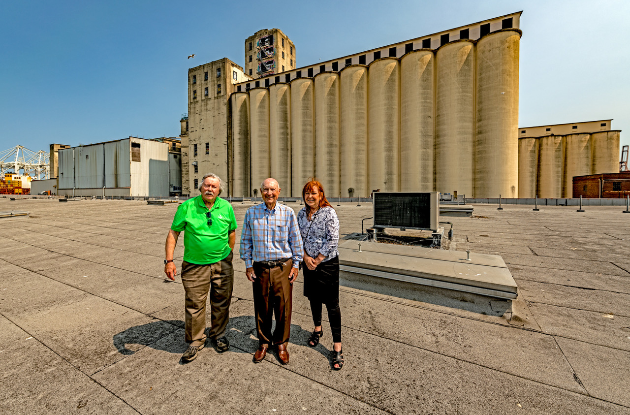
THEN: A 1917 view of the Fisher Flouring Mill looking northeast across the Duwamish River’s west channel. Harbor Island, completed in 1909, was built of fill from the Yesler and Jackson Street regrades and dredge spoils from the river’s bed. Until the late-1930s, it was the largest artificial island in the world. (courtesy Phelps Fisher)NOW1: Standing atop the shuttered mill’s vast warehouse are (from left) author and scone-maker Jim Erickson, Phelps Fisher and Kate Becker, King County creative economy director. Becker heads efforts to repurpose the warehouse as a film and TV production studio. (Jean Sherrard)
Published in The Seattle Times online on June 22, 2023
and in PacificNW Magazine of the printed Times on June 25, 2023
The flouring Fisher family legacy–from scones to silver screen
By Jean Sherrard
A Now & Then pop quiz: What do the once-mighty Fisher Communications Company, the Puyallup Fair and recently crowned King Charles III have in common? A hint: It’s dense, fragrant and dolloped with butter, clotted cream and fresh jam.
Kudos to all who came up with (drum roll) … the scone.
Jim Erickson will sign copies of his book at the Invitation Bookshop in Gig Harbor on June 27, the Lakewood Barnes & Noble on June 30, the Puyallup Library on July 8, and King’s Books in Tacoma on July 11.
James Erickson, author of the lavishly illustrated “Washington’s Fisher Scones: An Iconic Northwest Treat since 1911,” records the pastry’s Scottish origins. He guesses that the medieval town of Scone (also noted for the Stone of Scone, atop which all British monarchs have been crowned for 800 years) may have baked an eponymous prototype in the early 1500s.
In his new book, Erickson documents the entrepreneurial, non-royal Fishers, who, seeking opportunities in a booming port city, relocated in 1911 from Montana to Seattle.
Just-completed 350-acre Harbor Island at the mouth of the Duwamish River, constructed of fill from dredging and recent Seattle regrades, with ready access to shipping and room to grow, proved the ideal location for their flour mill.
Largest in the western United States, the Fisher plant was “equipped to grind about 10,000 bushels of wheat … [and] create 2,000 barrels of flour a day.” But in the fiercely competitive flour business, Erickson writes, effective ads were key. Reaching into its Scotch ancestry, the family decided “to make scones and give them away or sell them for a nickel.”
In 1915, the “sweet treats” were debuted to acclaim at the Panama-Pacific International Exposition in San Francisco, followed that year with the first annual appearance of a Fisher Scone booth at the Puyallup State Fair.
A decade later, another promotional brainchild beckoned. Fans of the then-new medium of radio, the Fishers purchased a broadcast frequency — available following the arrest of its previous owner, notorious Seattle bootlegger Roy Olmsted. The station, KOMO, went on the air Dec. 31, 1926, promoting Fisher Blend Flour.
In years to come, the family built a local media empire comprising dozens of radio and TV stations. Phelps Fisher, today a vigorous 90-year-old, worked his way up from the flour mill to chair the board of Fisher Communications.
For Fisher, it’s always been about family. “We worked together, supported each other and managed to get along,” he says. The result: “a wonderful, honest, productive business for the better part of the 20th century.”
Kate Becker welcomes Phelps Fisher (left) and Jim Erickson to a vast soundstage inside the 117,000-foot former Fisher Flour warehouse, now Harbor Island Studios. During the pandemic, several TV series were produced here, including an Amy Poehler production, “Three Busy Debras.”
The flour mill was sold to Pendleton Flour Mills in 2001 and recently was transformed to a film studio. Meanwhile, Fisher Communications was acquired by Sinclair Broadcast Group in 2016. The Fisher Scone, notes Jim Erickson, “has outlived the very brand it served to promote.”
Phelps Fisher on the steps of the former Fisher Flour office building..
Plus a few more photos from the former Fisher Flour/now Harbor Island Studios site:
A huge “green screen” in place at Harbor Island Studios.The last time Phelps Fisher visited, the warehouse was filled with sacks of flour.A southeast view from the warehouse roof along a branch of the Duwamish river.A trapdoor in the warehouse reveals the waters of the Duwamish below.A northerly view of the huge flour mill.
THEN1: In this snowy scene from winter 1888, the steamboat Cascade, piloted by Captain George W. Gove, stops along the Snoqualmie River at The Landing, later renamed Fall City, next to today’s state Highway 202. Hauling hops from nearby farms, it also picked up stacked 4-foot cordwood. This is the cover photo for “Steamboats on the Snoqualmie,” a book by Steve Barker and Jack Russell. Built in 1884, the Cascade last operated in 1901. Visible onshore with a dog is 8-year-old Albert Moore, later a farmer and North Bend Timber fire warden. (Courtesy Snoqualmie Valley Museum)NOW1: Gathering 200 feet east of the “Then” photo site are (from left) the co-authors of “Steamboats on the Snoqualmie,” Steve Barker and Jack Russell, with 11 Snoqualmie Valley heritage enthusiasts. Also displayed is a three-foot scale model of the Black Prince, the last sternwheeler to ply the Snoqualmie River as far as just below Duvall. Its final run, in 1928, was to remove equipment and machinery from an old mill. The model is owned by the Tolt Historical Society. Others pictured are (standing, from left) Kelly Barker, wife of Steve Barker; Hideko Fletcher, partner of Jack Russell; and, holding the Black Prince model: Jim Jordan, Tolt Historical Society trustee; Gene Stevens, Fall City Historical Society historian; and Rick Divers, Fall City Historical Society president. Sitting (from left) are Maida Ingalls, Tolt Historical Society president; Kris and Dick Kirby, Snoqualmie Valley Museum board member; Diana Anderson Amos, Tolt Historical Society volunteer; Marion Querro, Fall City Historical Society volunteer; and Donna Driver-Kummen, Fall City Historical Society board member. Barker and Russell will speak about their book Oct. 20, 2023, to the Fall City Historical Society. More info: Barker-Russell.com. (Jean Sherrard)
Published in The Seattle Times online on June 15, 2023
and in PacificNW Magazine of the printed Times on June 18, 2023
Soothing steamboat runs ended in upriver Snoqualmie in 1917
By Clay Eals
All 13 of those posing in this week’s idyllic “Now” scene came to the riverbank across from downtown Fall City by car. So did Jean Sherrard and I. Indirectly, the needs and wants of us and our collective forebears are why this section of the Snoqualmie River hasn’t seen a paddle-driven steamboat in well over a century.
THEN3: A side view of the 99-foot sternwheeler Cascade, as it backs up on Puget Sound in the late 1880s. (University of Washington Special Collections)
In the late 19th century, steamboats, also called sternwheelers, were part of Puget Sound’s celebrated Mosquito Fleet and a prime mode of transport for hops, timber and people in rural waterways. But their navigation fell victim to unmistakable signs of growth and progress — the complicating cables and booms of cross-channel ferries and bridges, the parallel routes of new railroad lines and the coming popularity (and rumble) of automobiles and trucks. Steamboat runs upriver as far as past Duvall, ended by 1917.
Thus, any rivercraft sailing past Fall City today consists only of recreational rowboats, rafts and kayaks.
But oh, for the days of steamboats, yearn childhood pals Steve Barker and Jack Russell. Now straddling age 78, they devoted their four most recent years to assembling a new, large-format book, “Steamboats on the Snoqualmie.” Its 148 pages overflow with 130 historical photos, six intricate maps and myriad details of elegant vessels from a seemingly gentler time, with names like the Traveler, the Ranger and the May Queen.
The softcover volume focuses on what we might call three “S-es”: the Snoqualmie River and to a lesser extent its downstream siblings, the Skykomish and Snohomish — a system emanating from the Cascades and snaking to saltwater in a northwesterly direction from above Snoqualmie Falls to Everett.
THEN2: As sixth-graders in 1957, Jack Russell (top row, far left) and Steve Barker (top row, far right) stand in a class photo at Hawthorne Elementary School in the Rainier Valley. They have been friends for 67 years. (Courtesy Jack Russell)
Russell, of unincorporated Skyway (between Seattle and Renton), and Barker, of Duvall, met in the fifth grade in 1955-56 at Hawthorne Elementary School in the Rainier Valley. Their families bore sternwheeler connections that buoyed their 67-year friendship.
NOW2 (online only): Co-authors Steve Barker (left) and Jack Russell stand in the pilothouse of Russell’s Christine W sternwheeler at Fishermen’s Terminal. Russell charters tours for up to 48 people. (From “Steamboats on the Snoqualmie“)
Barker, a retired banker, was the primary writer and Russell the researcher. Russell also parlayed his steamer passion into an adult vocation he still practices today. He runs a Fishermen’s Terminal-based charter service on the 1993-vintage Christine W, the only commercial sternwheeler on the Sound. It embodies an appeal the book can only attempt to capture.
“It’s the smell of the steam and the cylinder oil. It’s not a diesel chugging away,” Russell says. “It only goes 5 to 6 mph, so it’s a gentler motion. And steam whistles can be very pretty, very melodious. It just sounds different and feels different than a propeller vessel.
“And when the paddlewheel turns, you can hear the wheel hitting the water. It’s a soothing sound.”
WEB EXTRAS
Thanks to Ruth Pickering, Lisa Oberg and especially Steve Barker and Jack Russell for their invaluable help with this installment!
To see Jean Sherrard’s 360-degree video of the “Now” prospect and compare it with the “Then” photos, and to hear this column read aloud by Clay, check out our Seattle Now & Then 360 version of the column. It includes the sounds of a sternwheeler whistle and paddleboat.
February 2023 cover of the Fall City Historical Society newsletter.Steve Barker and Jack Russell with Russell’s sternwheeler, the Christine W. (Clay Eals)The Christine W sternwheeler is The boat is named for Jack Russell’s niece Christie (September 1973-July 2002). who died cancer. (Courtesy Jack Russell)The Olympic sternwheeler plies the Sammamish River near Bothell. (Courtesy Jack Russell)March 13, 1891, Seattle Post-Intelligencer.Jan. 18, 1894, Anacortes American.March 31, 1935, Seattle Times, p33.Sept. 29, 1947, Seattle Times, p30.April 4, 1954, Seattle Times, p82.June 7, 1954, Seattle Times, p29.June 9, 1954, Seattle Times, p12.June 10, 1954, Seattle Times, p2.June 11, 1954, Seattle Times, p42.March 4, 1956, Seattle Times, p22.
Here is one of the photos of an inclined coal railway whose location had been identified as in south Bellevue but whose true location has been confirmed by the Newcastle Historical Society. It’s 100 miles north along the southeast shore of Lake Whatcom, five miles southeast of Bellingham. This is the “looking down” photo described below. (Eastside Heritage Center, L90.24.10)
Actual site of ‘Newcastle’ photos is
100 miles north of Lake Washington
(Editor’s note: For this blog post, we invite two guests from the Newcastle Historical Society to contribute a lesson in historical research!)
By Matt McCauley and Kent Sullivan
Newcastle Historical Society
As embarrassing as mistakes can be, in the realm of historical research it is particularly important to correct the record when one inevitably goofs. Here is our journey through the stages of grief:
In the case of research on Seattle’s first railroad, constructed in the early 1870s by Seattle Coal & Transportation Co., our ad hoc group of historians had as the centerpiece of its research two beautiful 19th century photographs of the inclined railway that the company constructed in today’s south Bellevue, the location of which was known at that time as Bensonville.
Coal cars were lowered down the steep incline to a wharf, where they continued their journey, in the finest Rube Goldberg fashion, up Lake Washington to today’s Montlake neighborhood, then across another short stretch of rail, then on another barge ride across Lake Union, and then down a final stretch of rail to another incline at the foot of Pike Street, upon which the cars were lowered then dumped into coal bunkers at the company’s salt water wharf.
The coal was then loaded onto ships for transport to San Francisco and other distant markets.
Here is the second of two photos whose true location has been confirmed by the Newcastle Historical Society. It’s 100 miles north along the southeast shore of Lake Whatcom, five miles southeast of Bellingham. This is the “looking up” photo described in this post. (Eastside Heritage Center, L90.24.09)
These two photos of the incline are quite striking, though their provenance was a bit hazy. A local family had brought prints to the old Marymoor Museum in 1990. The prints previously were in the possession of a family ancestor who had been involved in 19th century coal mining in the Newcastle area.
The family did not want to donate the prints to Eastside Heritage Center, so the prints were photographed on the spot, which was the best-available method in 1990 for quick reproductions, and they were filed away with sparse notes.
Much later, the old Marymoor Museum’s collections were transferred to the then-new Eastside Heritage Center, and it was from the Eastside Heritage Center that the Newcastle Historical Society learned of, and became keenly interested in, them.
In fact, it was the re-discovery of these images that prompted the formation of our ad hoc Seattle Coal and Transportation Co. research team, which brought together people who previously did not know each other and are now good friends — an unexpected but happy outcome.
Our team of eight — Robert Boyd, Harry Dursch, Gary Dutt, Mike Intlekofer, Eva Lundahl, Russ Segner as well as the two of us — did years of research and collected considerable information, including a major, unsuccessful effort to locate the original prints.
We eventually went public a few years ago with our findings by giving several presentations, which led to Jean Sherrard and Clay Eals inviting us to collaborate on this “Now & Then” column from September 2019.
(Our team also provided deep background research on the 1850s-1870s mining era for the recent revision of the classic local history book “The Coals of Newcastle.”)
Shortly after the release of the “Now & Then” column about our research, we heard from Andy Valaas, a local resident with an interest in history whom we did not previously know. He first came across these images in an online presentation by Jane Morton of Eastside Heritage Center and did not believe the two images of the incline were of our incline.
A few things struck Andy:
First, as a long-time downhill skier, he thought the incline in the photos was too high and too steep to have been along the southeastern shore of Lake Washington.
Andy also believed the type of steam donkey engine seen in one of the photos would have not yet been in use while the Newcastle incline was in operation (1872-1878).
In addition, he believed the shape of the Mercer Island shoreline did not match closely enough what could be seen in the “looking down” photo. (Of note: Matt had previously taken several “today” photos and studied early shoreline maps, the upshot of which was that a match seemed possible, although not iron-clad.)
Andy gently brought these concerns to our attention, and, as experienced historians do, Andy also did a bit of research to try to establish where the pictured incline was actually located.
Prompted by a well-known picture of coal cars on a barge on Lake Whatcom, some five miles southeast of Bellingham, Andy focused his research about 100 miles north of Lake Washington. Andy’s research pointed to the Blue Canyon Coal Mine on Lake Whatcom’s southeast shore. This incline was constructed circa 1891 and had much more of a drop (820 feet vs. 175 feet at Newcastle).
Needless to say, Andy’s input sparked much discussion among our group.
We had not really questioned the basic location of the incline up this point. Our work had mainly focused on finding the location of it “on the ground” today, which we were successful in doing and is not doubted. This led us, as a group, to exercise just enough confirmation bias to explain away things that didn’t quite fit:
The shoreline in the distance of the “looking down” photo wasn’t a 100% match for Mercer Island.
The steam donkey visible in the “looking up” photo was from a slightly-later era.
The length and steepness of the incline seemed too extreme for the topography in today’s south Bellevue.
Mike Intlekofer on our research team had raised the donkey concern previously but we had explained it away as a “pioneering use,” while we rationalized that the apparent length and steepness of the incline was due to the photographer using a wide-angle lens of some sort.
Grieving, our Seattle Coal and Transportation Co. research group got through the “denial” and “anger” phases fairly quickly. Then Harry Dursch on our team contacted retired Western Washington University geology professor George Mustoe, who, at first, questioned whether the images were at Blue Canyon — which gave us a brief sense of hope, as being in the “bargaining” phase often does.
The Blue Canyon incline, looking down. (Whatcom Museum X.4001)
We then reached out to photo archivist Jeff Jewell of the Whatcom Museum. Jeff sent us straight to “depression” because he was able to quickly provide us with several images of the Blue Canyon incline, including views we had never seen before, along with much-crisper versions of the images we had previously obtained from Eastside Heritage Center.
Another view of the Blue Canyon incline, looking down. (Whatcom Museum, 1996.10.3301)
The presence of the same four trees in the Eastside Heritage Center and Whatcom Museum “looking down” photos made it unquestionably clear that the photos were not taken along Lake Washington. (See A–D in the accompanying comparison image.) The same Whatcom Museum image also made it clear that we were not looking at the east shore of Mercer Island.
These two annotated crops make it clear that the images that Newcastle Historical Society members obtained from Eastside Heritage Center were of the Blue Canyon incline rather than at Newcastle. (Left: EHC L90.24.09; Right: WMPA X.4001. Graphic assistance: Noel Sherrard)
No historians worth their salt would deem a painful lesson of learning and enlightenment to be complete without arriving at “acceptance,” which we did in fairly short order, although some of us may or may not have drowned our sorrows first at the Mustard Seed Too in Newport Hills.
We have since embarked on the mighty challenge of locating a sketch, drawing, photo or painting of the Bensonville incline, the one the Seattle Coal and Transportation Co. built circa 1872. Unfortunately, the corporate records of Seattle Coal and Transportation Co. appear to have largely been discarded by a successor company, so sketches and drawings that must have existed at one time likely no longer exist.
What makes finding a photo a substantial undertaking is the state of photography in the 1870s. At that time, photographers used the “wet plate” method. This means:
Prior to making an exposure, the photographer needed to use a light-free environment to coat a glass plate with liquid emulsion.
That “wet” plate was then placed into a light-free magazine that was slid into the back of a wooden box camera.
The light block was removed and the camera’s lens cap pulled away to allow the image to be exposed onto the glass.
The light block was replaced, the magazine removed from the camera, taken back into the dark area, removed from the magazine and immediately immersed in liquid developer and fixer to create a glass plate negative from which prints could be made.
Needless to say, any photographer taking images of outdoor features needed a literal wagonload of equipment: an unwieldy camera and tripod, liquid chemicals (in fragile glass bottles) and some kind of tent or other means for a portable darkroom.
Given this complexity, it is understandable why most 1870s-era photographers chose instead to do portrait work inside of studios, with adjacent darkrooms and chemicals.
We had assumed that the extraordinary effort it would have required to make these images was due to the company documenting the large sums from its San Francisco owners and investors were being spent wisely.
We recognize that the odds of us finding images of the Bensonville incline are vanishingly remote, But we will keep looking. One never knows. Historical research is full of unexpectedly delightful discoveries!
THEN1: In March 1984, artist Marvin Oliver is interviewed by a local TV news crew near the traditional pole he designed. To view a 2018 interview with Oliver discussing his life and art, please visit pauldorpat.com. (Victor Steinbrueck)NOW1: Minutes before construction workers detached it from a support structure, Marylin Oliver poses in front of her brother’s traditionally designed pole.
Published in The Seattle Times online on June 8, 2023
and in PacificNW Magazine of the printed Times on June 11, 2023
Downed totem poles in Market’s Steinbrueck Park will rise again
By Jean Sherrard
There’s a temporary gap in Seattle’s smile. If you’ve visited the Pike Place Market recently and strolled its northern limits, you may know that something’s missing.
On a blustery Sunday in April, two 50-foot-tall totem poles that stood in Victor Steinbrueck Park for nearly 40 years were painstakingly detached from their steel and concrete supports. The weather-battered sentinels were lowered by crane to waiting truck beds on the new Elliott Way and hauled into city storage for the duration of the now-shuttered park’s reconstruction.
The history of these colorful and beloved works of art begins with one man’s passion.
Architect, designer and preservationist Victor Steinbrueck (1911-1985), credited with saving Pike Place Market from the wrecking ball, sought a work of art to crown a small park just north of the Market, co-designed with Gasworks Park creator Richard Haag. The goal “was to honor the people who have come before,” says daughter Lisa Steinbrueck, “on land formerly occupied by Coast Salish people.”
Hoisted by a crane, the Farmer’s Market pole features male and female figures intended to memorialize the Pike Place Market’s farmer/producers.
In 1982, Steinbrueck commissioned Quinault artist Marvin Oliver (1946-2019) to produce two contrasting totem poles. Then in his mid-30s, Oliver was a University of Washington professor, acclaimed for his innovative application of traditional forms.
In two years, Oliver and carver James Bender completed both poles. The first, topped by back-to-back male and female figures, honored founders of the Market’s Farmer’s Market. The second, of traditional design, arranged figures, from bottom upward, of bear, orca, human and a raven clutching a Coast Salish spindle.
Mayor Charles Royer dedicates the installed poles in then-Market Park in 1984. (Victor Steinbrueck)The same view just before the poles were removed. Elliott Way opened for traffic days later.
Their installation in 1984 was marked by the entire city. Mayor Charles Royer spoke to an appreciative crowd in then-Market Park, covered widely on TV and radio and by both daily newspapers. Following Steinbrueck’s death in 1985, the park was renamed for him.
By contrast, the poles’ recent removal was unheralded, leaving onlookers perplexed. “I grew up with them,” said one Market regular. “Aren’t they city landmarks?” (They aren’t.)
Steinbrueck family members kept vigil, with Oliver’s sister Marylin. She monitored progress throughout the day, ensuring that the poles never touched dirt (if they had, by tradition, destruction must follow). She has embraced a mission — that her brother’s faded artwork “be restored by other Native artists and carvers.”
Side by side, the poles fill a 50-foot-long truck bed. A 40-year perch above the waterfront have left them needing restoration.
Shannon Glass, Seattle Parks senior project manager, says the poles likely will be reinstalled with fanfare when Victor Steinbrueck Park reopens.
For Marylin Oliver, this cannot come too soon. “History cannot be taken away,” she says. “It can be renewed.” A return of the poles, she says, will “bring healing to the city.”
WEB EXTRAS
Lots of extra photos with details of the poles’ removal. And for those interested in hearing more from artist Marvin Oliver, click through to the following video, recorded by Jean Sherrard at the Pike Place Market in 2018.
Dick Falkenbury, with portrait of what could be David Denny. (Clay Eals)
Seeking your help with a puzzling portrait
By Clay Eals
Recently I met with Bremerton resident Dick Falkenbury, an activist and former cabbie who is best known for leading the failed Monorail campaign in the late 1990s and early 2000s.
He gave me a portrait that he picked up for $20 at a thrift store, and he thinks it might be of famous founder David Denny. It sits very loosely in a frame, as can be seen in the accompanying photo.
Dick merely wants me to find a good home for it. But he also is curious if there is a way to verify that it is of David Denny. All available photos of Denny show him with some form of facial hair, and this portrait does not. I’ve checked with experts at HistoryLink.org, the Museum of History & Industry and the Washington State Historical Society but found no definitive answers.
So to our blog audience, two questions:
Do you think it’s David Denny?
Where might be the best home for this?
If you have information or insights, please email me. Thanks!
THEN: This Nov. 16, 1911, scene, looking southeast along streetcar-tracked California Avenue at its intersection with Lander Street, shows the birth of Olmsted-designed Hiawatha Playfield, the first Seattle park to combine a fieldhouse (rear center) with outdoor recreation. A football practice is ensuing at center. Foreground storefronts include Central Grocery, which sold Seattle Ice Cream. The photo was taken from an upper floor of castle-like West Seattle Central School, which shed its elder grades in 1917 when West Seattle High School was built in the clearing at upper right. (Webster & Stevens / Seattle Municipal Archives)NOW1: In this aerial view, Hiawatha Community Center (formerly fieldhouse) peeks through the trees at back center, flanked by West Seattle High School at upper right beneath Mount Rainier. A Safeway stands on the former Corner Grocery site at lower left, and two low-slung Lawson Cypress trees straddle the park’s corner entry at lower left-center. (Jean Sherrard)
Published in The Seattle Times online on June 1, 2023
and in PacificNW Magazine of the printed Times on June 4, 2023
For first-of-its-kind Hiawatha Playfield, the trees are the keys
By Clay Eals
NOW7: Visiting West Seattle from across the pond in Silverdale, Frankie Foozer, 9-year-old great-nephew of “Now & Then” columnist Clay Eals, rides high on the Hiawatha Playfield swings. (Clay Eals)
To my childish eyes in the 1950s, the swing set at West Seattle’s Hiawatha Playfield was the tallest in the world. As an adult, I enticed my daughter and nephews (and their kids) to the park with the same claim. For no matter your age, when you pump hard and swing high on those swings, you feel like you just might touch the nearby treetops.
This scenario fits the groundbreaking role that Hiawatha holds among Seattle parks. Though West Seattle had been annexed only four years prior, this squarish tract became, in 1911, the city’s first public place for indoor/outdoor recreation. The 11 acres comprised a fieldhouse for meetings and games, a ballfield and tennis courts for athletics, and paths and groves for respite and reflection.
NOW5: This placard and two other Olmsted-related signs hang on the south side of the Safeway across Lander Street from Hiawatha Park. (Clay Eals)
Our “Then” photo was taken 50 days before the Jan. 5, 1912, opening of Hiawatha’s “sumptuous” fieldhouse, as described by the Seattle Post-Intelligencer. Some two-dozen trees dot an otherwise shorn and barren landscape. But as we see in our “Now” image, the foresight of the legendary Olmsted Brothers, Seattle’s early 20th-century park designers from the East, made possible a more lush fate, creating an Admiral neighborhood showcase.
NOW2: Tree expert Arthur Lee Jacobson measures the trunk of Hiawatha Playfield’s “Heritage Tree,” a Red Oak. For more info on Jacobson and his nature books, visit ArthurLeeJ.com. (Clay Eals)
One could lyrically surmise that its trees are the keys. Arthur Lee Jacobson, known as “Mr. Tree” for the 1989 and 2006 editions of his encyclopedic book “Trees of Seattle,” embraces Hiawatha because trees were integral to its conception, not “an incidental afterthought.”
The park’s scores of varieties include a majestic Red Oak (a “Heritage Tree,” says nonprofit PlantAmnesty) whose dimensions, measured anew by Jacobson, stretch 133 feet wide and 78 feet tall, with a trunk circumference of 15 feet, 8 inches. And it’s not even halfway toward a 250-year life expectancy.
NOW3: A pair of low-slung Lawson Cypress trees, whose technical name is Tamariscifolia, welcomes those who visit Hiawatha Playfield from its northwestern entrance. (Clay Eals)
Though Hiawatha provides many access points, its stairstep entry at the southeast corner of California Avenue and Lander Street offers an evergreen treat absent in 1911. It’s the comforting canopy of two robust, low-slung Lawson Cypress trees, imbuing visitors beneath them with an aura akin to photographer W. Eugene Smith’s famously forested tableau of two youngsters, “The Walk to Paradise Garden.”
NOW4: A Seattle Parks posting provides details on anticipated upgrade projects at Hiawatha Playfield. (Clay Eals)
The park, named by the late West Seattle philanthropist and park commissioner Ferdinand Schmitz for a precolonial Native American leader lionized by poet Henry Wadsworth Longfellow, has hardly been static. Hiawatha’s fieldhouse — enlarged in 1949, rebranded as a community center in the 1970s and closed since 2020 — is slated for an upgrade, as are the park’s playground and its ballfield’s artificial turf.
The trees of Hiawatha, too, are ever-changing. Yet their sturdiest specimens keep beckoning a skyward gaze from the child in us all.
NOW6: Longtime West Seattle art-gallery proprietor Diane Venti, with sons Antonio (left) and Enzo, escape the heat beneath an entry Lawson Cypress tree at Hiawatha Playfield on July 21, 2018, during the West Seattle Grand Parade. (Clay Eals)
WEB EXTRAS
Thanks to Karen O’Connor, Ken Bounds, Ya-Hui Foozer, Chris Eals, Frankie Foozer, Diane Venti and especially Arthur Lee Jacobson for their invaluable help with this installment!
To see Jean Sherrard’s 360-degree video of the “Now” prospect and compare it with the “Then” photos, and to hear this column read aloud by Clay, check out our Seattle Now & Then 360 version of the column.
Click this image to download a pdf of Seattle Parks’ Don Sherwood file on Hiawatha Playfield.Click this image to download a pdf of Seattle Parks’ schematics envisioning renovation to Hiawatha Community Center.Click this image to download a pdf of the city’s Hiawatha Tree Walk.Hiawatha Park construction notice. (Clay Eals)Hiawatha Park construction notice. (Clay Eals)This placard and two other Olmsted-related signs hang on the south side of the Safeway across Lander Street from Hiawatha Park. (Clay Eals)This placard and two other Olmsted-related signs hang on the south side of the Safeway across Lander Street from Hiawatha Park. (Clay Eals)A pair of low-slung Lawson Cypress trees, whose technical name is Tamariscifolia, is seen from inside Hiawatha Playfield at its northwestern entrance. (Clay Eals)The cover of the 2006 second edition of Arthur Lee Jacobson’s “Trees of Seattle.” For more info on Jacobson and his nature books, visit ArthurLeeJ.com.Tree expert Arthur Lee Jacobson points out Hiawatha Park’s “Heritage Tree,” a Red Oak. For more info on Jacobson and his nature books, visit ArthurLeeJ.com. (Jean Sherrard)Tree expert Arthur Lee Jacobson measures the trunk of Hiawatha’s “Heritage Tree,” a Red Oak. For more info on Jacobson and his nature books, visit ArthurLeeJ.com. (Jean Sherrard)From a distance, Arthur Lee Jacobson uses a laser rangefinder to measure the height and breadth of Hiawatha Park’s “Heritage Tree,” a Red Oak. For more info on Jacobson and his nature books, visit ArthurLeeJ.com. (Jean Sherrard)From a reverse view, looking northwest, here is an aerial view from 1930-1932 of the California and Lander intersection, with Hiawatha Park in the lower left. Among many visible buildings are West Seattle Central School at center, the former Sixth Church of Christ Church at lower right, and the Portola Theater, predecessor of the 1942 Admiral Theatre, at upper right. A clumsy, oval-shaped attempt at repair of this print appears at the upper right corner. (Clay Eals collection)Feb. 9, 1909, Seattle Post-Intelligencer, p2.March 10, 1910, Seattle Times, p2.Aug. 28, 1910, Seattle Times p10.Aug. 31, 1910, Seattle Times, p9.Sept. 2, 1910, Seattle Times, p26.Sept. 4, 1910, Seattle Times, p22.July 16, 1911, Seattle Post-Intelligencer, p26.July 29, 1911, Seattle Post-Intelligencer, p10.Sept. 12, 1911, Seattle Post-Intelligencer, p10.Oct. 1, 1911, Seattle Times, p44.Nov. 24, 1911, Seattle Times, p17.Jan. 5, 1912, Seattle Times, p16.Jan. 6, 1912, Seattle Post-Intelligencer, p9.Jan. 7, 1912, Seattle Times, p13.June 30, 1912, Seattle Post-Intelligencer, p25.June 29, 1913, Seattle Times, p14.Oct. 15, 1914, Seattle Times, p13.April 17, 1939, Seattle Times, p14.Sept. 13, 1984, Seattle Times, p37.Feb. 6, 2003, Seattle Post-Intelligencer, p73.April 2, 2003, Seattle Post-Intelligencer, p6.