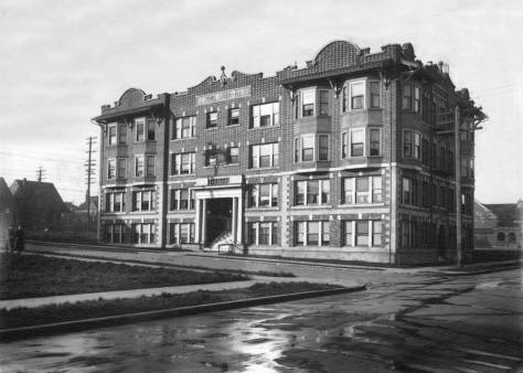
THEN: The Cascade neighborhood, named for its public grade school (1894), now long gone, might have been better named for the Pontius family. Immigrants from Ohio, they purchased many of the forested acres north of Denny Way and east of Fairview Avenue.NOW: The Colwell Building at the northwest corner of Denny Way and Stewart Street opened in 2000. It was named for Rev. David Colwell, the Congregational minister who is credited with starting the Plymouth Housing Group, which and builds affordable housing in Seattle for the homeless and working poor.
This is the farmhouse where Margaret and Rezin Pontius raised their five children: three boys, Frank, Albert and Lincoln, and two girls, Mary and Emma. The photographer was the prolific Theodore Peiser, whose pioneer studio was one lot south of the southeast corner of Marion Street and Second Avenue, or was until the Great Fire of 1889 destroyed it and most of his negatives. Either this print escaped the flames, or the undated subject was recorded after the fire.
The Photographer Theo Peiser’s advertisement in the 1887 Polk City Directory presents his case with wit which if somewhat stretched is still a sincere exception to the facile fun now had with our merciless huckstering. It is also a good – if implied – recommendation from his primary school teacher and the thousands of poems that were once regularly printed in the nation’s periodicals. It seems to me. CLICK CLICK TO ENLARGE
That’s Margaret posing near the front porch. By this time the three sons were all grown and working in town. Lincoln, the youngest, was a machinist, Albert a blacksmith, and Frank, the oldest, a druggist and for the years 1887-88, King County Treasurer. The year for Peiser’s visit was, I’ll speculate, about 1890. There are several homes climbing the Capitol Hill ridge on the horizon behind Margaret. All of them were built on land that she, with her sons, had sold. First settled by Rezin in the late 1860s and platted in 1880 as the Pontius Addition, north of Denny Way it extends east from Minor Avenue up Capitol Hill as far as 14th Avenue.
A detail from the 1908 Baist Real Estate Map showing some of the reach of the Pontius additions. North is at the top. CLICK-CLICK to ENLARGE.
In the 1879 Pitt’s Directory for Seattle, Margaret is listed as a “farmeress” on the “Lake Union Road.” By 1890, the Pontius farmhouse was also a real estate office, and the family’s fortune multiplied with an influx of neighbors, of which there was a growing swarm following the fire. By then, Rezin was long gone, having disappeared after an argument with Margaret. Thereafter, by Margaret’s authority, he was a forbidden subject. When needed, she listed herself as a widow. After Margaret’s death, Rezin was reunited with his children, living out his life with Frank in Bothell.
ABOVE: With some of Mother Rhyther’s children on the porch and front steps and BELOW without them.
First appeared in The Times on Feb. 5, 1995. CLICK-CLICK to ENLARGELong before the Amazon and Vulcan developments rocketed through the Westlake and Cascade neighborhoods, both the Pontius Farmhouse and the nearby mansion were on blocks thirteen and 24 of the Pontius 4th Addition just north of Denny Way. The footprint of the mansion shows in the lower-left quarter of the Baist map printed above on lots 8 & 9 of its 13th Block. By 1908 the farmhouse was long gone. The mansion was later razed for the Greyhound garage, which is now no more. When I photographed the “now” I was, I turns out, about one lot east of the proper prospect. Note the alley crossing north and south through block 13 between John and Denny Way in the map. Most likely that is the alley figuring in the above look at Greyhound across Denny Way. The “now” shot dates from the mid 1990’s when it was used in The Timesfor the feature on the big home, which is printed again immediately above this “now” shot. Immediately below this caption we’ve inserted the thirty-first of the Times feature writer Margaret Pitcairn Strachan’s well-wrought study of fifty-two Seattle mansions. Some were still standing when she produced her weekly series in 1944-45. I have covered many of these same big homes in the last 34 years and confess to having often borrowed from Strachan.Margaret Strachan’s feature on the Pontius family, their homes, enterprise and often stressed family life. CLICK CLICK CLICK THIS and there is at least a chance that you can read it.)
In 1889 Margaret built the family a Gothic mansion with a landmark tower about a hundred feet west of the farmhouse. Margaret was known for her conflicting passions of great charm and violent temper, which were conditioned by her charities. She gave much of her steadily increasing wealth to the care of children. After her death in 1902, the Pontius Mansion became the Mother Rhyther Home for Orphans in 1905 and continued so until 1919.
Above a Dec. 1, 1899 adver for Pontius lots and below it a Dec. 30, 1910 notice regarding the removal of a house in the way of extending Stewart Street to Eastlake Avenue and so at least in part through the site of the Pontius farm house and garden.
A Dec. 30, 1910 clip from The Times.An investment opportunity that leans on the salesman’s understanding that the expected “extending of Stewart Street making a boulevard from Westlake to Eastlake” will double the values of lots nearby.
If I have figured correctly, with the help of other photographs and real estate maps, the Pontius farmhouse originally rested both beneath and beside the footprint for the Colwell Building, a six-story apartment with 124 units for low-income tenants, seen in the “now.” Opened in 2000, it was named for Reverend David Griffith Colwell, the Congregational minister who helped found the Plymouth Housing Group in 1980, which now manages one thousand units of low-income housing in twelve structures. With his death in 2001, Colwell left a legacy of good works, including twenty years of helping the homeless in Seattle.
David Colwell in The Seattle Times report of September 7, 1967 on his first sermon before the Plymouth Congregational congregation.
WEB EXTRAS
Anything to add, boys? Surely Jean. Ron Edge has found a half-dozen links from the neighborhood, much of it the Pontius domain, which climbed up Capitol Hill to its summit on 14th Avenue. We used only a few of the stories we have told from that real estate kingdom. Below these links I’ll introduce a few earlier ones and three McDonald panoramas from the early 1890s that include the Cascade neighborhood – and much else. In all three the Pontius mansion can be found and in one of them their farm house as well. Their quite close to each other. Ron also appears below – in the second link- if our readers open it. It is a Peterson & Bros pioneer photo Ron found of another farm in the neighborhood. Jean posed Ron in the “now.” Together we, Ron, Jean and I, figured out the farm’s location a few blocks north of the Pontius farm.
========
THREE OLD MCDONALDS
1. From FIRST HILL
This early 1890’s McDonald pan looks north from near Union Street and Terry Avenue on First Hill. Wallingford is on the far shore of Lake Union. Above the center of the subject and a little to the left, the Pontius mansion tower is seen with the lake. About two large lots to the east you can also find the farm house that is featured at the top of all this. It was this pan that solved the long abiding and frustrating problem for me of locating the earlier Pontius home. There it is! And just below is a detail of that telling part of McDonald’s helpful pan. CLICKCLICKCLICK to enlarge.
A detail that shows the Pontius mansion, on the left, and the Pontius farm house on the right. (Courtesy, MOAHI aka The Museum of History and Industry.)
===
2. From DENNY HILL (This McDonald pan was given its own feature on June 29, 2003.)
One can fine the Pontius mansion on the far left of this detail taken from the above McDonald pan from Denny Hill. But not, I think, the farm house. The grading beyond and up Capitol Hill follows, I believe, the line of John Street.
===
3. From QUEEN ANNE HILL (It is more difficult to find the Pontius big home in this McDonald pan to the southeast from Queen Anne Hill, but it is there on the far right if you click-click-click.)
=======
FOLLOW A FEW FEATURES FROM THE NEIGHBORHOOD (Or Near It)
First appeared in Pacific, April 14, 2002.
===
First appeared in Pacific, March 21, 2002.
===
First appeared in Pacific, Sept. 11, 1988.
===
Gethsemane Lutheran, nearby at 9th and Stewart.
===
Zion Lutheran (German) at Stewart and Terry, and back-to-back with the Swedes.
===
The Greyhound depot, nearby at 8th and Stewart.
===
The WARD home at Boren and Pike. First appeared in Pacific,January 3, 1999.
===
Fini: THE WAY OF ALL FLESH – AND PROPERTY
A March 30, 1902 Times report on the Margaret Pontius funeral.Her son Albert follows in the spring of 1914, leaving his portion of the family wealth to his oldest brother Frank, who was once the city treasurer. Which may suggest to some of us that it is time to think of giving our stuff up while we can still describe it, and give much of it with love outside the family, that is philanthropically.
THEN: In 1913, or near to it, an unnamed photographer recorded this view southeast across the Lower Queen Anne corner of Denny Way and First Avenue North. Out of frame to the left, the northeast corner of this intersection was home then for the Burdett greenhouse and gardens. (We have include an advertisement for them below.) By its own claim, Burdett offered plants of all sorts, “the largest and most complete stock to choose from in the state.” Courtesy, the Museum of North Idaho.NOW: Jean discovered that the lower and larger panel of this correctly chosen window was stuck closed, so instead he extended his camera through a narrow opening to the side of the upper panel and recorded this view, which sees considerably farther south on First Avenue. Thanks to archivist Julie Keressen at Seattle Municipal Archives for discovering that the part of Denny Way seen here was considerably widened to the south in the early 1920s. A combination of that widening and Jean’s extended arm open up the view south on First Avenue and into Belltown.
While Seattle was building long piers with landmark towers on the central waterfront and first staging Golden Potlatches, the week-long summer festivals that began in 1911, on city streets, an alert and now nameless photographer produced a collection of sharp negatives enamored with schooners, steamers and Potlatch parade floats.
The window shot at the top, however, is unique for her or him. From the northwest corner of First Ave. N. and Denny Way, the subject looks southeast from a fourth floor window – perhaps the photographer’s apartment.
This detail pulled from the 1912 Baist Real Estate Map has Denny Way running along the bottom. The Regent Apartments are show – although not named – near the map’s lower-left corner at the northwest corner of Denny Way and First Ave. North. Not counting the fire station (far right, on a site now supporting the Space Needle), there are eleven brick buildings (the red ones) scattered among the wooden ones in these 21 lower Queen Anne blocks. [CLICK TO ENLARGE]
The Regent Apartments were built in 1908. From the prospect, here at the top, one got an unimpeded view of the razing of Denny Hill for the Denny Regrade until 1910, when the Raymond Apartments, whose rear wall is seen here kitty-corner and beyond the billboards, opened its 37 two-room units to renters. The Regent was considerably larger with 59 units. These two apartment houses were part of the earliest brick reconstruction of this “North Seattle” neighborhood that had been swiftly built of wood during Seattle’s first boom decades of the 1880s and 1890s.
The Raymond Apartments, here renamed the Wm. Daniels Apartments, rise above a trolley turning west onto Denny Way from First Avenue. The reader may decide if the couple, clutching their purses and packages and watching the trolley, are preparing to board it or waiting for it to pass by, allowing them then to cross Denny Way.. The Regent/Arkona Apartments are just off the photo’s border to the left, behind them.With his back to the Arkona, Lawton Gowey recorded this look down First Avenue on November 2, 1968. The date is penned on this slide’s cardboard frame, but not for another of Gowey’s Kodachrome cityscapes, the one immediately below. (It was unlike him not to write down a date.) We can tell from the distant skyline that the snap below is later than the one above.Ivars sign here still holds to the north facade of the Raymond Apartments. Included below with the Link named “Sharred Walls” is a feature on the Raymond – seen from the front.The sign to Ivar’s Fish Bar on Denny Way. The variety of menus was something he introduced in the 1950s with his first drive-in housed in a converted Capitol Hill gas station on Broadway Avenue at Thomas Street..
The Regent’s managers did not promote this view south into the business district but rather that to the west. A Dec. 15, 1912, classified ad for the Regent reads, “Commanding a view of the Sound and being within easy walking distance of the city, or excellent car service, this building is exceptionally well located. The apartments are first class and modern in every respect. Three rooms at $15 and $20. Four rooms, $27.50 and $30.”
The 15-year-old Regent was sold to California investors, and pictured in the January 28, 1923 Sunday Times. [CLICK TO ENLARGE]
In 1925, after the apartments were sold to a San Francisco investor for “a consideration of $110,000,” the name was changed to the Arkona. This was short-lived. After John and Winifred Paul purchased the Arkona Apartments in 1927 for $150,000, they whimsically changed its name to Pauleze. Winifred died there in 1932, but Paul continued living in and managing their apartment house until 1957, when he too died, but not the punning name. It remained the Pauleze until the late 1970s, when, for reasons we have not found, the name Arkona Apartments was revived.
Jack Paul’s obituary as is appeared in The Seattle Times for Dec. 6, 1957.
In the mid-1980s, with the help of Dave Osterberg, a friend who was then the development manager for Environmental Works, acting as guide for the transfer, the collection of negatives of which this subject was one, “came home” to Seattle from the Museum of North Idaho. With a donation to the museum from Ivar Haglund, the negatives were purchased for the University of Washington Libraries, Special Collections.
A page from The Seattle Times for March 10, 1910, which includes an advertisement for The Burdett Company nursery that was directly across First Ave. North from the Regent’s front door. The detail from the 1912 Baist Map printed above reveals that this verdant concern filled most of the block north to John Street. CLICK TO ENLARGEAn early 20th Century look up First North from Denny Way. My notes advise “about 1903.” If so then still five years before the construction of the Regent/Ankona. The long lot on the far right is home for the Burdett nursery.Here too we look north on First Avenue North thru Denny Way. The Ankona is on the left, and here as well Lawton has not dated his slide – unless he has and I missed it. (That seems more likely.) Here the traffic is two way, but not so in the Gowey slide directly below. Time has passed there. With the Ankona on the left and still looking north on one-way First Ave. North with traffic heading only north in 1971,
WEB EXTRAS
Anything to add, dear Paul? At first – and perhaps last – look Ron and I have found a dozen links to past features, all from within the still brief life of this blog: a few years. They are packed with Queen Anne – both upper and lower – history.
The first of these twelve includes brief illustrated essays on sever other Seattle apartment houses, including the Raymond, which is the pie-shaped brick apartment at the corner of Warren and First that partially blocks the view from our window above into both the regrade and the central business district. Following the links I’ll hang a some more images from the neighborhood, either before climbing to nighty-bears, or tomorrow. Meanwhile there is enough included in the dozen links below to keep one engaged for a long as it once upon a time took one to sit thru “Meet the Press.”


 ===
===


