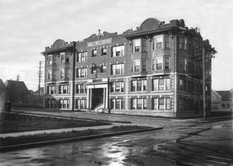
THEN: Constructed in 1885, the Alice and Clarence Bagley mansion was the first big home built on the south slope of Queen Anne Hill. (Courtesy Lawton Gowey)NOW: Gus Holmberg built the first floor of his apartment house at 200 Aloha Street in 1945 and added the second floor in 1959. Since their use as a home-site in the 1993 ‘buried alive’ horror film, “The Vanishing,” the apartments have figured in local movie lore.
This is the tower in which Seattle’s most prolific pioneer historian, Clarence Bagley, may have written his many-volume histories of Seattle and King County. I assume he used it so, for why else would such a writer-publisher-printer build such a tower with a full panorama of the city, if not for inspiration? The Bagley mansion, designed by an eastern architect, was built in 1885 on the south slope of Queen Anne Hill on a block-sized lot now bordered by Second and Third Avenues North, and Aloha and Ward Streets. One of the earliest homes on the Hill, and certainly the first oversized one, the mansion’s rooms had twelve-and-a-half foot tall ceilings, and a furnace and five fireplaces to warm them. The tower was Clarence’s idea, and “he loved it.” It was decorated with Bagley’s collection of rifles and muskets.
The neighborhood in 1908 with block 24, upper-right, still reserved for Bagley’s big home.
The big home was used for collecting and entertaining, perhaps as much as for raising a family of four daughters and one son. The Bagley library included what was at one time considered the largest collection of regional history. Clarence was generous with its uses, as when this newspaper, The Seattle Times, lost much of its library to a fire in 1913, he replaced itslost editions with his own.
A clipping from The Times for Dec. 27, 1925. CLICK AND CLICK to Engarge
Clarence Bagley was sixteen-years-old when he and his parents arrived on the first wagon to roll into Seattle in 1860. With a few stops to visit friends along the way, the Bagleys’ jostled drive from Salem, Oregon, had taken fifteen days. Thomas Mercer’s wagon was the first to reach Seattle, in 1853, but he and his wagon had traveled from Steilacoom by boat. In 1852 the Bagleys and the Mercers had journeyed west together from their native Illinois. As part of a pioneer Oregon Trail wagon train, it took five months to reach Salem, Oregon.
Time’s columnist John Reddin’s feature on Cecil Clarence Bagley, hie parents and the family home, printed on March 8, 1967. The long feature continues below.
On Christmas Eve 1865, Mercer’s youngest daughter, Alice, married Clarence in Seattle’s first church wedding. Friends since their childhood in Illinois, he was twenty-two and she seventeen. The Methodist church was white and so was the town, then under two feet of snow. Their four daughters were married in the Queen Anne mansion’s front parlor with the bay window. On Christmas Day in 1925 their children and friends filled the mansion for the celebration of the couple’s 60th Anniversary.
A Seattle Times clip from Oct. 13, 1945.
Alice Mercer Bagley died in 1926, and “Pop” Clarence lived on in their mansion until 1938, when he, too, died after nearly a half-century in his tower. The big home was torn down early in 1944 to make way for apartments.
The Bagley home from nearer the top of Queen Anne Hill, looking southeast to a Capitol Hill horizon. First appeared in Pacific, Sept. 27, 1998.
=====
WEB EXTRAS
I’ll drop in a couple of alternate views of the apartment building on Aloha.
Looking south towards downtownA pleasant view into the courtyard
Anything to add, boys?
Sure Jean, while hoping your vacation south from Paris into the verdure of a Perigord summer with plenty of castles and vinyards for your pleasure and Berangere and her family and much of yours too, is being enjoyed with some prudence and sobriety at the bottom and belt line. First, before moving on to Ron Edge’s links, we will answer your “extras” on the surviving apartment there at 2nd Ave. N. and Aloha Street with two of the same taken by Lawton Gowey in 1981. Lawton, you know, lived nearby and he took his photos as repeats for the historical landmark – the Bagley Mansion – he knew and may have remembered from his adolescence living on the hill. Then after the Edge Links we will keep to the neighborhood with a few more older features we’ve accumulated through the years and finish by leaving Queen Anne for a small portfolio of snapshots taken on Bagley Avenue in Wallingford.
Lawton Gowey dated this Kodachrome and the slide that follows Nov. 2, 1981.
=====
EDGE LINKS – CLICK TO ENTER
=====
First appeared in Pacific, May 3, 1992.
===
Click Click to EnlargeLooking north up the Queen Anne Avenue Counterbalance from Mercer Street. (Courtesy, Lawton Gowey)First appeared in Pacific, January 11, 1998.
===
First appeared in Pacific, March 10, 1991.
===
First appeared in Pacific, November 26, 1995.
===
First appeared in Pacific, May 18, 2003.
===
First appeared in Pacific, January 4, 1987.
===
First appeared in Pacific, April 27, 1986.
===
First appeared in Pacific, May 21, 2000
===
First appeared in Pacific, Sept 7, 1986.CLICK CLICK CLICK to ENLARGE The still isolated Bagley home can be found in this three-part panorama taken from the back porch of the Bell Hotel at the southeast corner of Battery Street and Front Street (First Ave.). It stands alone and yet tell below what remains of the forest on the Queen Anne Hill horizon, and very near the center of the pan when measured from left (west) to right (east).
=====
BAGLEY IN WALLINGFORD ca. 2008
A high chair at the northeast corner of Bagley and 45th Street.
===
Still at the northeast corner of Bagley and 45th.
===
The family dog inspects he painting job in progress on the family home, east side of Bagley, mid-block north of 45th Street. This one is dated Sept. 27, 2006.
===
Sunset, Nov. 20, 2008, looking west from Bagley about ten yards or twelve north of 45th Street.
===
It’s the off to bed hour (aka nighty bears time), and so we will do one of our minimal proofs in the morning – late.
THEN: The Cascade neighborhood, named for its public grade school (1894), now long gone, might have been better named for the Pontius family. Immigrants from Ohio, they purchased many of the forested acres north of Denny Way and east of Fairview Avenue.NOW: The Colwell Building at the northwest corner of Denny Way and Stewart Street opened in 2000. It was named for Rev. David Colwell, the Congregational minister who is credited with starting the Plymouth Housing Group, which and builds affordable housing in Seattle for the homeless and working poor.
This is the farmhouse where Margaret and Rezin Pontius raised their five children: three boys, Frank, Albert and Lincoln, and two girls, Mary and Emma. The photographer was the prolific Theodore Peiser, whose pioneer studio was one lot south of the southeast corner of Marion Street and Second Avenue, or was until the Great Fire of 1889 destroyed it and most of his negatives. Either this print escaped the flames, or the undated subject was recorded after the fire.
The Photographer Theo Peiser’s advertisement in the 1887 Polk City Directory presents his case with wit which if somewhat stretched is still a sincere exception to the facile fun now had with our merciless huckstering. It is also a good – if implied – recommendation from his primary school teacher and the thousands of poems that were once regularly printed in the nation’s periodicals. It seems to me. CLICK CLICK TO ENLARGE
That’s Margaret posing near the front porch. By this time the three sons were all grown and working in town. Lincoln, the youngest, was a machinist, Albert a blacksmith, and Frank, the oldest, a druggist and for the years 1887-88, King County Treasurer. The year for Peiser’s visit was, I’ll speculate, about 1890. There are several homes climbing the Capitol Hill ridge on the horizon behind Margaret. All of them were built on land that she, with her sons, had sold. First settled by Rezin in the late 1860s and platted in 1880 as the Pontius Addition, north of Denny Way it extends east from Minor Avenue up Capitol Hill as far as 14th Avenue.
A detail from the 1908 Baist Real Estate Map showing some of the reach of the Pontius additions. North is at the top. CLICK-CLICK to ENLARGE.
In the 1879 Pitt’s Directory for Seattle, Margaret is listed as a “farmeress” on the “Lake Union Road.” By 1890, the Pontius farmhouse was also a real estate office, and the family’s fortune multiplied with an influx of neighbors, of which there was a growing swarm following the fire. By then, Rezin was long gone, having disappeared after an argument with Margaret. Thereafter, by Margaret’s authority, he was a forbidden subject. When needed, she listed herself as a widow. After Margaret’s death, Rezin was reunited with his children, living out his life with Frank in Bothell.
ABOVE: With some of Mother Rhyther’s children on the porch and front steps and BELOW without them.
First appeared in The Times on Feb. 5, 1995. CLICK-CLICK to ENLARGELong before the Amazon and Vulcan developments rocketed through the Westlake and Cascade neighborhoods, both the Pontius Farmhouse and the nearby mansion were on blocks thirteen and 24 of the Pontius 4th Addition just north of Denny Way. The footprint of the mansion shows in the lower-left quarter of the Baist map printed above on lots 8 & 9 of its 13th Block. By 1908 the farmhouse was long gone. The mansion was later razed for the Greyhound garage, which is now no more. When I photographed the “now” I was, I turns out, about one lot east of the proper prospect. Note the alley crossing north and south through block 13 between John and Denny Way in the map. Most likely that is the alley figuring in the above look at Greyhound across Denny Way. The “now” shot dates from the mid 1990’s when it was used in The Timesfor the feature on the big home, which is printed again immediately above this “now” shot. Immediately below this caption we’ve inserted the thirty-first of the Times feature writer Margaret Pitcairn Strachan’s well-wrought study of fifty-two Seattle mansions. Some were still standing when she produced her weekly series in 1944-45. I have covered many of these same big homes in the last 34 years and confess to having often borrowed from Strachan.Margaret Strachan’s feature on the Pontius family, their homes, enterprise and often stressed family life. CLICK CLICK CLICK THIS and there is at least a chance that you can read it.)
In 1889 Margaret built the family a Gothic mansion with a landmark tower about a hundred feet west of the farmhouse. Margaret was known for her conflicting passions of great charm and violent temper, which were conditioned by her charities. She gave much of her steadily increasing wealth to the care of children. After her death in 1902, the Pontius Mansion became the Mother Rhyther Home for Orphans in 1905 and continued so until 1919.
Above a Dec. 1, 1899 adver for Pontius lots and below it a Dec. 30, 1910 notice regarding the removal of a house in the way of extending Stewart Street to Eastlake Avenue and so at least in part through the site of the Pontius farm house and garden.
A Dec. 30, 1910 clip from The Times.An investment opportunity that leans on the salesman’s understanding that the expected “extending of Stewart Street making a boulevard from Westlake to Eastlake” will double the values of lots nearby.
If I have figured correctly, with the help of other photographs and real estate maps, the Pontius farmhouse originally rested both beneath and beside the footprint for the Colwell Building, a six-story apartment with 124 units for low-income tenants, seen in the “now.” Opened in 2000, it was named for Reverend David Griffith Colwell, the Congregational minister who helped found the Plymouth Housing Group in 1980, which now manages one thousand units of low-income housing in twelve structures. With his death in 2001, Colwell left a legacy of good works, including twenty years of helping the homeless in Seattle.
David Colwell in The Seattle Times report of September 7, 1967 on his first sermon before the Plymouth Congregational congregation.
WEB EXTRAS
Anything to add, boys? Surely Jean. Ron Edge has found a half-dozen links from the neighborhood, much of it the Pontius domain, which climbed up Capitol Hill to its summit on 14th Avenue. We used only a few of the stories we have told from that real estate kingdom. Below these links I’ll introduce a few earlier ones and three McDonald panoramas from the early 1890s that include the Cascade neighborhood – and much else. In all three the Pontius mansion can be found and in one of them their farm house as well. Their quite close to each other. Ron also appears below – in the second link- if our readers open it. It is a Peterson & Bros pioneer photo Ron found of another farm in the neighborhood. Jean posed Ron in the “now.” Together we, Ron, Jean and I, figured out the farm’s location a few blocks north of the Pontius farm.
========
THREE OLD MCDONALDS
1. From FIRST HILL
This early 1890’s McDonald pan looks north from near Union Street and Terry Avenue on First Hill. Wallingford is on the far shore of Lake Union. Above the center of the subject and a little to the left, the Pontius mansion tower is seen with the lake. About two large lots to the east you can also find the farm house that is featured at the top of all this. It was this pan that solved the long abiding and frustrating problem for me of locating the earlier Pontius home. There it is! And just below is a detail of that telling part of McDonald’s helpful pan. CLICKCLICKCLICK to enlarge.
A detail that shows the Pontius mansion, on the left, and the Pontius farm house on the right. (Courtesy, MOAHI aka The Museum of History and Industry.)
===
2. From DENNY HILL (This McDonald pan was given its own feature on June 29, 2003.)
One can fine the Pontius mansion on the far left of this detail taken from the above McDonald pan from Denny Hill. But not, I think, the farm house. The grading beyond and up Capitol Hill follows, I believe, the line of John Street.
===
3. From QUEEN ANNE HILL (It is more difficult to find the Pontius big home in this McDonald pan to the southeast from Queen Anne Hill, but it is there on the far right if you click-click-click.)
=======
FOLLOW A FEW FEATURES FROM THE NEIGHBORHOOD (Or Near It)
First appeared in Pacific, April 14, 2002.
===
First appeared in Pacific, March 21, 2002.
===
First appeared in Pacific, Sept. 11, 1988.
===
Gethsemane Lutheran, nearby at 9th and Stewart.
===
Zion Lutheran (German) at Stewart and Terry, and back-to-back with the Swedes.
===
The Greyhound depot, nearby at 8th and Stewart.
===
The WARD home at Boren and Pike. First appeared in Pacific,January 3, 1999.
===
Fini: THE WAY OF ALL FLESH – AND PROPERTY
A March 30, 1902 Times report on the Margaret Pontius funeral.Her son Albert follows in the spring of 1914, leaving his portion of the family wealth to his oldest brother Frank, who was once the city treasurer. Which may suggest to some of us that it is time to think of giving our stuff up while we can still describe it, and give much of it with love outside the family, that is philanthropically.
THEN: The 1974 fire at the Municipal Market Building on the west side of Western Avenue did not hasten the demise of the by then half-century old addition of the Pike Place Market. It had already been scheduled for demolition. (Courtesy, Seattle Municipal Archive)NOW: Jean Sherrard describes this as “about the easiest repeat I have taken.” Both views look north on Western Avenue towards Virginia Street.
For a half century, the Municipal Market Building sat at the northwest corner of the Pike Place Market. Perhaps you do not remember it, although the shoe-box shaped structure with its crenelated roof somewhat resembled a fort. Here the effect is made sensational with a fire and enveloping smoke. The alarm was rung mid-afternoon on Wednesday, September 25, 1974. The fire was started by a cutting torch used with abandon by a lone worker salvaging steel tracks in the by then condemned and abandoned building.
A Seattle Times clipping from Sept. 26, 1974.Not the same fire! And earlier one on Western Ave. – and another Times clip, this from Nov. 11, 1961.
The Municipal Market Building was constructed on the west side of Western Avenue in the 1920s as a way to keep the market in the market. We explain. Combined traffic from north and south, Elliott and Western Avenues, respectively, reached Pike Place at Virginia Street. Already crowded with farmers’ stalls, the Market’s namesake Pike Place was increasingly used as a short cut to and from the business district. In this protracted battle between farmers and motorists, the city’s traffic engineers wanted to move the market to another uptown site, but Kitsap and King County farmers and their customers protested. They wanted it to stay on the scenic bluff.
The Municipal Market building can be found in this early 1930s aerial by first finding the armory building near the lower-left corner (just above the “Wn.” in the photo’s own caption) and moving from the armory up and to the right. There’s the show-box shaped Municipal Market Building and its bridge over Western Ave. to the long row of Market stalls on the west side of Pike Place. Note the long gaps parallel to the bay in Railroad Avenue. The 1934-36 seawall construction has not started. Harborview hospital, 1930, is on the First Hill horizon. [We recommend DOUBLE-CLICKING to enlarge.]
The political balance was tipped in favor of Pike Place, in part because of the addition of the Municipal Market Building. Parking on the roof enlarged its service, and the lot was reached directly from Pike Place over Western Avenue via the Desimone Bridge, seen here (at the top) in both the ‘now’ and ‘then.’
The Armory seen from near the entrance to the RR tunnel.
This mid-20s addition to the Market was given its modest military design to compliment the fortress-like Washington State National Guard Armory (1909-1968), its neighbor to the north across Virginia Street. In a Seattle Times advertisement from October 9,
From the Oct. 9, 1923 issue of The Times.
1923, the new Municipal Market was not ‘up in arms’ but umbrellas, “a thousand or two” of them. Seattle’s street railway was holding a “Going, Going, Gone” auction for six months worth of unclaimed items left on the trolleys. Also in its first decade, visitors were lured over the Desimone Bridge with vaudeville performances staged in the Municipal Market Building. A 1946 feature in The Times noted “the eternal rummage sales in the Municipal Building.”
I took this roughly merged 360 degree pan from the Desimone Bridge ca. 1980, and so about five years after the razing of the Municipal Market Building. CLICK TWICE!! (Dorpat)The Muncipal Market Building can be found here just above the Alaskan Way Viaduct and left-of-center. A few cars are parked on the roof. Work on the First National Bank building, far-right, is approaching its topping off, ca. 1967-8. CLICK-CLICK.
What the fire of 1974 could not consume, which was most of it, demolition crews soon took. The site was then groomed for parking – steep parking. After forty years of oil-stained pavement, the Public Market is now enlivened with new visions for the old Municipal Market space. It will be joined with land freed by the razing of the Alaskan Way Viaduct. Some of Seattle’s usual progressive choices will be involved in the about three-fourths of an acre development, including a promenade or walkway to the waterfront, more market shops, more senior housing, a new public plaza on top and more covered parking below.
A Market full-page ad from the Seattle Times for Nov. 19, 1953.
WEB EXTRAS
Anything to add, boys? Jean we figure it is about time now for you to wake-up in London, perhaps in that charming little Youth Hostel two blocks of three above the north bank of the Thames and two or three blocks more to St. Paul’s – if memory serves me from 2005. Ron has put up directly below a few of our by now usual suspect, past features from the neighborhood around the Pike Place Market. For the space below those links, I’ll find a few more distant features and scan their clips.
=====
Left of center – or right of the left border – the Hotel York shows why it was advertized as a “scenic hotel.” This pan – courtesy of Ron Edge, again – was taken in the late 1890s so all of what shows in the way of waterfront docks are short-lived contributions from the 1890s. This includes the Ainsworth Pier at the foot of Pike Street. It was replace ca. 1900 with the pier we have now, the one that anchors the Waterfront Park and is home to the aquarium. [CKICK-CLICK]=====
This 1907 look north up Pike Place must be considered the market classic. The stalls are yet to be built, so most of the commerce is done from the farmer’s wagons. The Hotel York, victim of the railroad tunnel below it, has left a hole on the right – behind the billboards. (Courtesy, Oregon Historical Society)First appears in Pacific on April 25, 1982. CLICK-CLICK
=====
First appeared in Pacific, May 24, 1987. CLICK-CLICK
=====
First appeared in Pacific, June 3, 2007.The featured photo in the insertion just above was photographed from the Standard Furniture Co. building, which can be found in the accompanying 1904-5 Sanborn map on the west side of Western Avenue, second lot north of Pike Street. Some of the “cheap cabins’ sketched north of the furniture co. building match – with some imagination – the modest dwelling showing in the featured photo between Standard Furniture and the Seamen’s Institute. CLICK-CLICKIt should look familiar. Western Avenue, and the Pike Street pedestrian crossing, 1975. [Photo by Frank Shaw]Pike Place to the right and Western Ave. to the left of the parkets long shelter for its stalls. The Seamen’s Hall is in the shadows far left, and the typical armory profile is center-horizon. Compare to the 1912 Baist map directly below. CLICK-CLICKA detail of the Pike Place Market neighborhood lifted from the 1912 Baist Map. Note the furniture warehouse, bottom-center, from which the look up Western showing three (and five) photos of it was captured.A portrait of the Seamen’s Institute across Western Ave. from the Market.
=====
1903 excavation of the bluff below Virginia Street for the north rortal of the railroad tunnel.First appeared in Pacific January 30, 2000.The tunnel’s north portal ca. 1904, when still a work-in-progress.Work at the north portal, ca. 1903-4. The tunnel workers’ dormitories are lined up above the opening. Later the Municipal Market Building would nestle on that ledge.
THEN: Looking north-northeast from the corner of Main Street and Occidental Avenue two or three weeks after the city’s Great Fire of June 6, 1889. (Courtesy the Museum of History and Industry – MOHAI)NOW: The two-story brick structure that was built on the corner a few years following the Great Fire housed the Carrolton Hotel upstairs and a variety of small businesses at the street level. The building was razed first for parking in the 1960s. In 1971 the parking lot was transformed with cobble stones as a part of Occidental Park.
I am writing this on June 6, 2015, the 126th anniversary of Seattle’s Great Fire. Most likely you are reading it about one month later. That places you closer to the 126th anniversary of this subject, which in 1889 was still Seattle’s primary business district, reduced to charred rubble. The scene was photographed, I surmise, late in the month of June or perhaps even in early July.
Some of the same tents and brick piles show in this view that looks northeast across Main Street to Second Ave. (Occidental Ave.). The County Courthouse at Third and Yesler appears on the right and the Yesler Mansion on the east side of Third, high-center. Part of Central School at Madison and 6th Ave. , fills the upper-left corner. (Courtesy, MOHAI)The corner of Second (Occidental) and Main appears with tents, far-left, in this look to the southwest from the front porch of the King County Courthouse, later to known as the Katzenjammer Kastle during its long run as Seattle’s city hall. (Courtesy, MOHAI)The Post-Fire ruins and tents, this time from the Katzenjammer tower. Mill Street (Yesler Way) crosses to the right from the lower-left corner. Jefferson Street meets it from the lower-right corner. West Seattle is on the horizon. “Our corner” of Main and Second (Occidental) is upper left, below the tall ships. The temporary tent that crowds bottom-left in the photo above this one, appears here also at the bottom, right-of-center. A contemporary repeat for this would be taken high in the trees along the west border of City Hall Park.
With the help of the many surviving photographs of the ruins, it is easy to determine from what prospect this scene was recorded. The unnamed photographer stood on Main Street looking north by northeast over Main Street’s northwest corner with Second Avenue (later renamed Occidental.) It is a typical post-fire cityscape that reveals a layering of ruins, temporary tents, and some of the surviving city blocks that were not among the 35 or so destroyed by the conflagration in its seven hours of wind-driven destruction.
First Methodist at the southeast corner of Marion and Third. [CLICK to ENLARGE]
Of the ten or so landmarks with towers that break the First Hill horizon we’ll note but three. First, far left, stands the Gothic spire of First Methodist Church at the southeast corner of Third Avenue and Marion Street. Next, at the scene’s center and farther up the hill, are the two towers of Central School on the south side of Madison Street, where now passes the Seattle Freeway (I-5) ditch. Much closer to the photographer, to the left of the scorched power pole, the Yesler mansion faces Third Avenue, on the north side of Jefferson Street. It was saved with a combination of soaked blankets spread on the roof and volunteers who extinguished the flying embers. Nearby, just right of the same power pole, another battle on the shingles saved the King County Courthouse. After the murder trail then underway was adjourned by Judge Hanford, buckets of water were lifted with a rope borrowed from the flagpole to drench the roof.
Appeared first in Pacific, March 21, 2002. [CLICK to ENLARGE]
By the 10th of June, four days following the fire, over one hundred permits had been issued to erect temporary tents. Like those shown here, most of the tents were stretched on sturdy frames and anchored to heavy planks. Months later some of these canvas quarters were still standing and being used as store fronts.
Looking south to a tideflats lined with rows of pilings placed speculatively as property lines in the hopes that the first state legislature would look upon such squatters and jumpers markings as keys to owning the land below the tides. Second Avenue – now Occidental – is right-of-center. Much of the neighborhood is well along with the construction of brick business blocks, but a cluster of temporary tents endures too. [Courtesy MOHAI]
Most of the pre-fire neighborhood south of Yesler Way was built of wood. Brick structures were rare. So the orderly piles of bricks here [in the featured photo at the top] encroaching on the street, right-of-center, is – or was – an inviting mystery. Except that almost certainly these bricks were salvaged from the wreckage of the large but short-lived Squire Building, here at the northwest corner of
A circa 1888 panorama of the neighborhood south of Mill (Yesler Way) taken from near 6th and Washington before the 1889 fire. Some day we will determine if the brand new and short-lived Squire Building is among the larger business blocks showing right of center.A detail from the 1888 Sanborn Real Estate Map showing the northwest corner of Main and 2nd (Occidental), bottom-right, prepared for the construction of the three-story tall Squire Block, the source also of our piles of salvaged bricks at the corner of Main and Second (Occidental) after the Great Fire.A Pioneer Square neighborhood detail from a 1925 real estate map. We have centered the detail on the Carrolton Hotel at the northwest corner of Occidental and Main.
Main Street and Second Ave. (Occidental). In the 1888 Sanborn real estate map this corner lot is captioned “Excavation for Brick Block to be three stories.” For his research on Pioneer Square neighborhood structures, Greg Lange found in the 1889 Polk Directory more than thirty tenants renting quarters in Watson Squire’s namesake block. Once the fire, heading south, reached Yesler Way around six pm, Watson’s renters must have already started gathering what they could before scrambling up First Hill.
A hand-color look north on Second Ave. (Occidental) in the mid-1870s from near Washington Street. The Occidental Hotel, between Mill (Yesler Way) and James Street, interrupted the grid. Jeweler-photographer Bob Bradley did the coloring directly on the 35mm slide, most likely in the 1950s.
=====
MORE POST-FIRE RUINS, TENTS & RECONSTRUCTION
The serviceable ruins of the Dexter Horton Bank (Seattle First National) show bottom-center at the northwest corner of Commercial Street (First Ave. S.) and Washington Street. Some of the skyline in this West Shore magazine rendering can be found in the top featured view on top.The Dexter Horton bank before the ’89 fire, at the northwest corner of Commercial Street (First Ave. S.) and Washington Street.And after. For more on this bank, see the last of Ron’s links at the bottom.
===
Looking north on Post Alley (or Street or Avenue) from Mill Street (Yesler Way) following the Great Fire. [First appeared in Pacific on April 22, 2007.]=====
Occidental Hotel ruins looking south from Front Street, (First Ave.) north of James Street.First appeared in Pacific, June 6, 2004.
=====
Yesler Wharf ruins looking east from the end of the dock. Compare the line-up of ruined buildings with those showing in two clippings up.
WEB EXTRAS
Anything to add, fellas? Yes Jean, but first Ron and I – and now the readers too – wish you and yours a happy farewell as you fly away to Europe with twenty-five (about) Hillside students and your protective cadre of instructors to visit first London and then Paris, and surely some of the same sites that you and I explored together in 2005. I will send you – as you have instructed – some shots I took when first visiting the same cities as a teenager in 1955, for your intentions to repeat them now sixty years later – gadz. Perhaps we can sneak them into Pacific – one or two of them. It will depend, I think, on how sentimental the editors are feeling at the time of submission, and the pun is intended. Bon Voyage Jean and carry our love to Berangere, who, I know, will be helping you in Paris. Often I’d just like to move there and follow BB around those ancient blocks with a bag of bon bons and one light weight digital camera.
THEN: From boxcars and rooftops to the planks of Railroad Avenue, excitement builds for the ceremonial re-enactment of the S.S.Portland’s 1897 landing with its “ton of gold” on the Seattle waterfront, the city’s first Golden Potlatch Celebration. [Courtesy, Michael Maslan]NOW: The Maritime Building (1910) on the left survives a century later, but the Alaskan Way Viaduct (1953) “has seen better days” and prepares now for its razing.
This subject is, almost certainly, the formal opening of the Golden Potlatch on the afternoon of Wednesday July 19, 1911. To find the ceremony itself we would need to go out-of-frame, far-right, following the attentions of those packed atop the long line of boxcars on the left. This rolling stock was often used as convenient bleachers through the many years that the waterfront, where “rail meets sail,” was stage (or platform) for local celebrations. With his or
Above and below: The Marion Street viaduct over Railroad Avenue (Alaskan Way) then and now – nearly now.
Posing on the Marion Street viaduct, Mach 3, 1911. The scene looks east.
her back to Madison Street, the photographer looks south on Railroad Ave (Alaskan Way) to the also packed Marion Street overpass. It was built by the railroads to permit safe passage for the hordes of locals and visitors here in 1909 for the city’s Alaska Yukon and Pacific Exhibition (AYP). The Golden Potlatch was, in part, an attempt by local boomers to recapture some of the civic splendor and hoopla that had accompanied the summer-long AYP. And the Potlatch had its own reverberations. As the first citywide, multi-day, summer festival, the several Potlatches were precursors for the now retirement-age annual Sea Fair celebration.
Part of the armada of steamers for the 1911 Potlatch – looking back from the Bay to Railroad Avenue.
Another prospect for watching the opening day ceremonies, from both the windows and the roof of the Maritime Building, on the left, fills the block between Madison and Marion Streets and Railroad and Western Avenues and rises five stories above the boxcars. It was filled with the offices and warehouse spaces for distributing the daily needs for foodstuffs and such brought here from distant lands (like California and Mexico). Built of reinforced concrete with lots of windows for light, the big building’s architect, contractor and builder was Stone and Webster, one of the nation’s great commercial octopi, with its tentacles already active in Seattle’s trolleys, interurbans, and power plants.
The Maritime Building on the right photographed from the Marion Street viaduct to Colman Dock.An artist’s rendering of the Maritime Building appearing in the Seattle Times for June 29, 1910.Railroad Avenue from the Marion Street viaduct during the 1916 “Big Snow.” The Madison Street north end of the Maritimes Building appears on the far right.
A gust from a mid-summer breeze flaps the American flag, top-center on the featured photo, posted above the southwest corner of the Maritime Building. Every corner had one. More evidence of the wind is the woman in the dazzling white blouse heading toward the photographer and holding tight with both hands her oversized hat. However, none of the men here seem worried for their own crowns.
Looking northwest and down on the intersection of Western Ave. and Madison Street from the nearly new Rainier Grand hotel on First Avenue. Note the Madison Street Cable Car approaching the intersection. Beyond the tall ships, a trestle for moving the mud of Denny Hill reaches into the bay. The new Maritime Buildings northeast corner appears far left.A Municipal Public Works department image looking north on Western from the Marion Street viaduct. The Maritime Building is on the left.Lawton Gowey’s June 20, 1965 “repeat” of the Municipal photo above it.
What are they watching? The ceremonial mish-mash of Kings and Queens, and performers acting as Alaskans landing aboard the “ton of gold” ship, the S.S. Portland, followed by a double line of navy ships, tooting Puget Sound “mosquito-fleet” steamers, and northwest yachts. Meanwhile overhead Curtiss aviators Ely and Winter flew back and forth. At two o’clock, the Gold Rush flotilla was scheduled to reach the Grand Trunk Pacific Dock, the largest wooden pier on the coast and in 1911 brand new. With fireworks, fireboat displays, and band concerts from the pier, the rubbernecked folks on the boxcar roofs were entertained until midnight.
A Pacific clipping from July 1, 1990 showing some of the Potlatch’s Railroad Avenue action, but in 1912, not 1911. [CLICK TWICE TO ENLARGE]
WEB EXTRAS
Anything to add, lads? MOSTLY waterfront features Jean. More to come tomorrow, perhaps. Proofreading too.


![It should look familiar. Western Avenue, and the Pike Street pedestrian crossing, 1975. [Photo by Frank Shaw]](https://i0.wp.com/pauldorpat.com/wp-content/uploads/2015/07/fs-western-back-of-pike-mrkt-1975-web.jpg?ssl=1)


![Looking south to a tideflats lined with rows of pilings placed speculatively as property lines in the hopes that the first state legislature would look upon them such squatters and jumpers markings as keys to owning the land below the tides. Second Avenue - now Occidental - is right-of-center. Much of the neighborhood is well along with the construction of brick business blocks, but a neighborhood cluster of temporary tents endures too. [Courtesy MOHAI]](https://i0.wp.com/pauldorpat.com/wp-content/uploads/2015/07/tideflat-post-fire-fm-near-2n-james-web.jpg?ssl=1)


![THEN: From boxcars and rooftops to the planks of Railroad Avenue, excitement builds for the ceremonial re-enactment of the S.S.Portland’s 1897 landing with its “ton of gold” on the Seattle waterfront, the city’s first Golden Potlatch Celebration. [Courtesy, Michael Maslan]](https://i0.wp.com/pauldorpat.com/wp-content/uploads/2015/07/potlatch-watch-above-railroad-ave-now-mr.jpg?ssl=1)
![NOW: From boxcars and rooftops to the planks of Railroad Avenue, excitement builds for the ceremonial re-enactment of the S.S.Portland’s 1897 landing with its “ton of gold” on the Seattle waterfront, the city’s first Golden Potlatch Celebration. [Courtesy, Michael Maslan]](https://i0.wp.com/pauldorpat.com/wp-content/uploads/2015/07/golden-potlatch-now.jpg?ssl=1)


