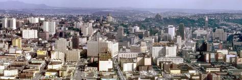
THEN: Looking west (not east) on Battery Street from Seventh Avenue, approaching the end of the last of Denny Hill’s six regrade reductions. The dirt was carried to Elliott Bay on conveyor belts like the two shown here. (courtesy Seattle Municipal Archives)NOW: The two forty-one story Insignia Towers now dominate the skyline and help fulfill the long stalled expectation of the original Denny regraders that when the hill was removed, it would be replaced with skyscrapers.
One of the Nevada Construction Company’s four “great electric power shovels” is at work on the right digging away to the north on what little is left of Denny Hill by March 15, 1930. Both the date and prospect are captioned bottom-left in the featured photo, most likely by James Lee, a photographer for the Seattle Engineering Department who by 1930 had been capturing our public works with both negatives and 16mm film for about two decades.
Battery Street looking east from the rear balcony of the Bell Hotel (shown in the next photo below) at the southeast corner of Front Street (First Ave.) and Battery Street ca. 1887-88. Denny School (1884) stands in the distance at the northeast corner of Fifth Avenue and Battery. Photo by Mumford.The Bell (aka Bellview) Hotel at the southeast corner of Battery Street and Front Street (First Ave.). The look up Battery street, ( the photo above this one), was photographed from the back of the hotel. The Austin A. Bell building stands beside it.This detail from the 1929 aerial survey of Seattle shows, bottom-right, the line-up or fan-shaped spread of the regrade’s moveable conveyors and how they meet at the main Battery Street conveyor about one block northeast of the intersection of Fifth Avenue and Battery Street. (Courtesy, Seattle Municipal Archive and Ron Edge) CLICK TO ENLARGELooking south to the Central Business District from the cliff left in 1911 when the regrading stopped at Fifth Avenue. This public works shot is date March 8, 1929. Battery Street is behind the city photographer. C LICK TO ENLARGEFifth Avenue, the border between the regrade completed to 1911 and then resumed in 1929 can be found by studying the building stock in the low-rise neighborhood the runs over the top-half oF this aerial from 1928-29. It seems to rise at a slant from the roof of the medical-dental building near the center of the subject. Frederick and Nelson is at the bottom-center. CLICK TO ENLARGE – MAYBE CLICK TWICE!
James Lee, it seems, was occasionally compass-challenged, as am I. (Jean is generally without flaw.) Both Lee and Jean are here looking west on Battery Street in the featured photographs at the top, and not east as is mistakenly hand-printed at the lower left corner of Lee’s print No. 8297. Seventh Avenue, however, is confident. It is a two-block walk – or ride on the regrade conveyor belts – to reach the low-rise business district that begins on the west side of Fifth Avenue. It was at Fifth that the Denny Regrade stalled
The same scrape-scape as that in the featured photo at the top only here seen earlier (Nov. 6, 1929) and looking south from a prospect near Fifth Avenue and Battery Street. Note St. James Cathedrals twin towers on the horizon, far right.Fifth Avenue where the main conveyor belt began its run west on Battery Street to Elliot Bay, both of which are out of frame to the right. The photo is dated May 17, 1929. . (Courtesy, Municipal Archive)The main conveyor running the length of Battery Street from Fifth Avenue to the waterfront. (Courtesy, Municipal Archive)
in 1911 for seventeen years. To the east of Fifth, a cliff was exposed – or created – that rose to a pie-shaped remnant of the hill, referred to as the “Old Quarter.” It was generally filled with homes – some of them large – that received few repairs and probably no restorations. The effect was that it got older, cozier and cheaper: a mix of rentals and family-owned homes, a neighborhood inclined to bohemian pastimes and street games. Regrading was expected to be completed eventually, but not so far-fetched as seventeen years later.
The “Old Quarter” is easily distinguished from the Denny Regrade in this ca. 1917 promotional rendering of what it calls the “apartment house district.” CLICK to ENLARGEOn the left, the “Old Quarter” looking north on Westlake from the Medical-Dental Building. The green acres of Denny Park are at the top, on the north side of Denny Way. Compare this with the cleared neighborhood showing two photos down.Fifth Avenue, the north-south dividing line between the regrade and the “Old Quarter” runs to this side of the temporary bluff. The view looks north toward Lake Union. The corner of Third Avenue and Virginia Street is at the bottom of the subject. Queen Anne High School stands up from the hill’s horizon, upper-left. CLICK-CLICK to ENLARGEIn preparation for the last of the Denny Regrades the “Old Quarter” east of Fifth Avenue has been mostly cleared away. Fifth Avenue – of course – is on the left. The Immaculate Heart tower topples at the corner of Sixth Avenue and Bell Street – with the help of explosives.
This was the last of the six regrades humbling Denny Hill. For the first two, in the mid-1880s and late 1890s, First Avenue was regraded initially for the horse cars, and later for the electric trolleys heading to and fro between Seattle and North Seattle, which was then Belltown and Lower Queen Anne. The remaining four regrades were all serious about eliminating Denny Hill as an obstruction to what the forces of regrade promoted as the “natural northern growth” of the city. Beginning in 1903, Second Avenue was brought to the grade we now know. In 1906 there followed the lowering of the south, or front, summit of the Hill between Pine and Virginia Streets and the razing of the grand Denny Hotel perched upon it. The lowering of the slightly higher north summit followed until 1911
The Denny Hotel with its last developer, James Moore (of the theatre too) scrambling to save it from the regraders. (See the same photo with the “extras” below and the short essay that accompanied it in Pacific for May 15, 2000.)Circa 1910, cliff formation to the east side of Fifth Avenue. The surviving center-section of Denny School appears to the right of the couple working at the cliff-top. The view looks north.The Klean-Rite Auto Laundry Co. garage at the southwest corner of Fifth Avenue and Battery in 1929 with the first section of the main regrade conveyor crossing 5th Ave. near the start of its journey to the waterfront.
when, as noted, all cutting stopped, leaving a cliff on the east side of Fifth Avenue. The cliff was just to this side of the white-faced one-story building at the center of the featured photo, at the southwest corner of Battery and Fifth Avenue. It is signed the “Klean-Rite Auto Laundry Co.” Spread out behind the laundry is the grand 1920-21 fire station No. 2 at the southeast corner of Fourth Avenue and Battery Street. (See next clip below.) On the afternoon that Public Works recorded this scene, more than two-hundred-and-fifty fire chiefs and municipal fire officials from around the state were meeting in No. 2’s big auditorium (on the left) for a three-day “fire-prevention convention.”
Appeared first in The Times, Aril 2, 1995.A clip from The Times for December 9, 1930.
Most of Denny Hill was eroded with water cannons, but not this last of the regrades. The “Old Quarter” was lowered with steam shovels that dumped their catches on to several moveable conveyor belts. The multiple belts led to a master conveyor that carried the last of Denny Hill west on Battery Street to be dumped into Elliott Bay. As it turned out, the deposits created an underwater Denny Hill, which for the safety of shipping ultimately required dredging.
A topped-off barge heading into the bay from the terminus for the Denny Regrade’s main conveyor Belt.
WEB EXTRAS
Anything to add, boys? Of course we do Jean, although we will need a second day to completed the laying in of more clips. Again and again it will be more past features from the neighborhood and now as well la recommendation for how to use this blog to find more about the Denny Regrade. First in the Illustrated History of the Seattle Waterfront included in our books “file” we have illustrated a history of the regrade. Key word it. And under the same file there will be more features about the regrade shared out of Seattle Now and Then, Volumes One, Two and Three. You could spend the rest of this Sunday on it. We suggest, however, the the reader begin with the first link below, “The First Shovel.”
=======
Courtesy of Louise Lovely, star of the One Reel Vaudeville Show.First appeared in The Times May 14, 2000.
=====
(Above: Looking south on the Wagon Road near Fifth and Virginia, ca. 1886. )
One thought on “Seattle Now & Then: The Last of Denny Hill, Part 1”
I can remember seeing these belts while riding the streetcars to downtown Seattle from our West Woodland neighborhood. (Our house is still there at 216 W 62nd St when last i checked.


I can remember seeing these belts while riding the streetcars to downtown Seattle from our West Woodland neighborhood. (Our house is still there at 216 W 62nd St when last i checked.