THEN: The Denny aka Washington Hotel on the double-block of Denny Hill’s southern summit. The view looks southwest over the intersection of Virginia Street and Fourth Avenue. (Courtesy, Museum of History and Industry)NOW: Once lowered about 100 feet, the blocks between Stewart and Virginia Streets and Second and Fourth Avenues were developed with a variety of post-Victorian structures, including the New Washington Hotel (now the Josephenum Apartments) at the northeast corner of Steward Street and Second Avenue. It is the brick early 14-story high-rise at 1902 2nd Ave. here right-of-center.
Gather round. It’s is time to repeat an old story about the commanding Arthur Denny, who, as the older of the two brothers who in 1851 first settled on Alki Point, has been generally considered the city’s founder and sometimes father. Denny first named the hill he owned at the north end of his claim, Capitol Hill. When his Seattle began both to fill in and out, the ‘papa pioneer’ expected that Washington Territory’s legislators, of which he was one, would ultimately flee Olympia and relocate their capitol on his hill and high above Seattle’s expanding commercial district. The move seemed a sensible expectation, but proved, however, to be more hunch than hit. Still, beginning in 1881, Seattle became the Territory’s largest community and stayed so. That was a mere thirty years after Denny and his party of mostly mid-western farmers with urban ambitions landed on Alki Point.
Looking south on Third Avenue from the front (south) summit of Denny Hill during the construction there of the Denny Hotel, later renamed the Washington Hotel. (Courtesy, Dan Kerlee)
Denny’s friends and fellow champions were just as pleased to name his hill for him. He was famously sober, steadfast, and demonstrably modest with the exception of his name, which he enjoyed having attached to real estate. Consequently, in 1888 ambitious friends convinced him to trade his political hopes for his hill into proprietary ones, while changing the hill’s name from Capitol to Denny.
Main lobby of the Denny Hotel. The grand entrance was to the left (south) and the registry desk to the right beside the steps that led to four flours of accommodations. (Courtesy, University of Washington, Northwest Collection)
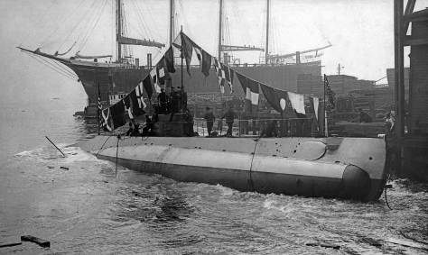
On March 20, 1889, less than three months before the city’s Great Fire of June 6, Arthur announced his plan to build a grand namesake hotel on his hill. In place of a capitol building he would settle for a Victorian landmark with 400 beds, one-hundred more than Tacoma’s Tacoma Hotel. Here (in the featured photo at the top) the Denny Hotel is recorded by a Webster and Stevens Studio photographer who is looking southwest from the northeast corner of Virginia Street and Fourth Avenue. Printed from a large glass negative, it is in the keep of MOHAI (Museum of History and Industry.) The year is 1903, or fourteen years after construction began, and the hotel was not yet finished.* A combination of infighting among the investors, the size and expense of the place, and the 1893 economic crash with the doldrums that followed, turned the grand hotel into a “ghost palace”, “white elephant” or “unsightly mass”, all names attributed to it in the local press.
Above and below: Looking north over the Steward Avenue “ditch” to the decorated hotel at the time of its opening in 1903. (Courtesy, University of Washington Libraries, Northwest Collection)
The May 23, 1903 issue of the weekly The Seattle Mail and Herald. (Click to Enlarge)The Denny Hotel from Second Avenue looking north. (Courtesy Dan Kerlee)Looking south of Third Avenue from Blanchard Street (near the northern summit of Denny Hill) at the rear of the as yet unopened or renamed Denny Hotel. The Northern Pacific photographer F. Jay Haynes, most likely recorded this in in 1892, and so still eleven years before the hotel was first opened to Theodore Roosevelt and his entourage as the Washington Hotel.Looking north on Third Avenue from the rear of the Denny Hotel. Queen Anne Hill is on the horizon. (Courtesy, Lucy Campbell Coe) CLICK to ENLARGE
Still empty, the hotel was being polished and prepared for its first guest, President Theodore Roosevelt. Sometime not long after Roosevelt anointed the landmark, Arthur Lingenbrink, my long-since deceased friend, visited the hotel with his parents and younger brother Paul, all of whom had moved to Seattle in 1903. When the family first approached the city from the south above the Union Pacific’s tidelands trestle, the gregarious ten-year-old Arthur, better
Arthur Lingenbrink in his basement studio on Capitol Hill.
known as Link, was dazzled by the hotel on the hill. Link kept his eye on the hotel, which by then was renamed the Washington Hotel by its new owner, James Moore, at the time Seattle’s super developer. The name change did not bother the founder. Arthur Denny died in 1899. The short-lived hotel’s demise followed in 1906, when this double-block was razed to its present elevations, early in the regrade of Denny Hill.
James Moore, the local super-developer who first opened the Denny Hotel in 1903 and renamed it the Washington Hotel.First printed in The Times on May 14, 2000.
WEB EXTRAS
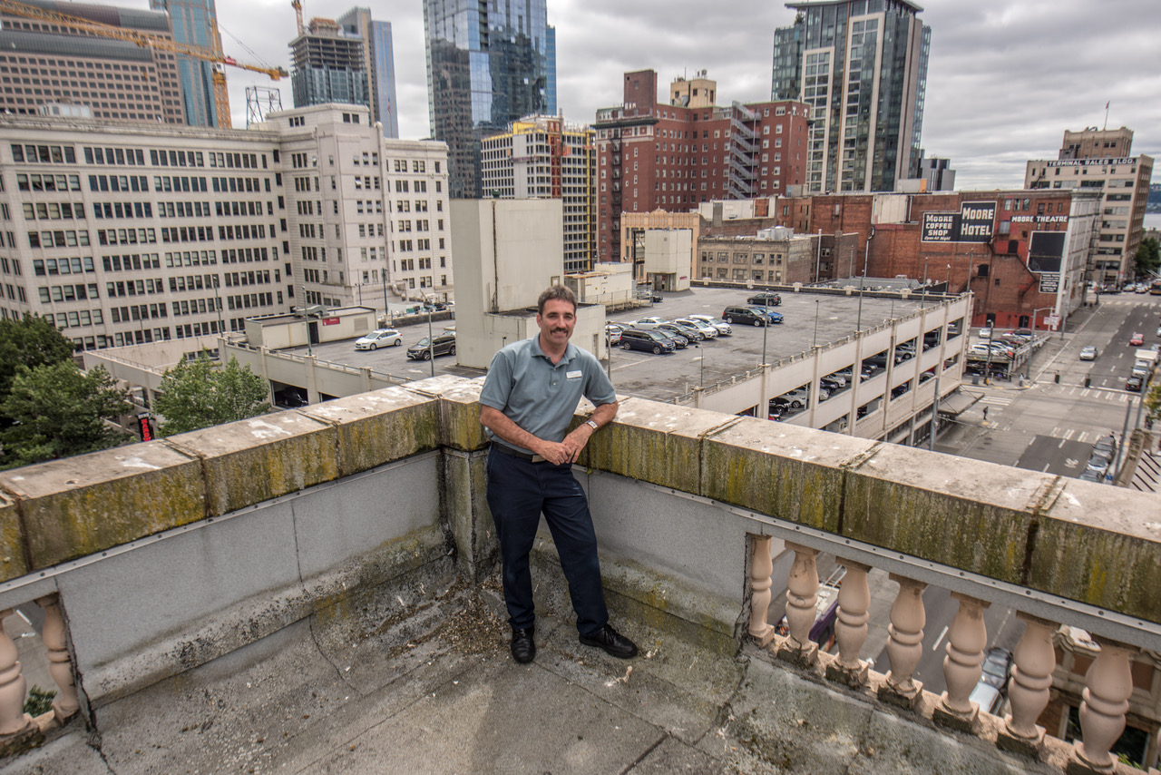
I’ve clambered around atop the Hotel Andra several times to repeat old prospects and my invaluable guide and pal Chief Engineer Brian Cunningham has always been along for the ride. Thanks, Brian!
Brian Cunningham on the Hotel Andra roof
Anything to add, my dears? Edge Clips from the neighborhood below and a few more to follow with their dangling texts.
=====
=====
The right (south) half of this pan is interpreted below. CLICK TO ENLARGE (Courtesy, Washington State Museum, Tacoma. The pan (of three parts) was photographed from the Washington Hotel by A. Curtis.)
=====
Denny Hill from First Hill
=====
=====
I photographed this “now” while on my way to a HISTORYLINK meeting, then in the Joshua Green Building at the southwest corner of Pike and 4th Avenue.
=====
First printed in The Times on February, 6, 2000.
=====
CLICK TO ENLARGE – Assemble out of Seattle Now and Then, Vol. 1.
=====
Denny Hill and its hotel recorded from the King Street Coal Wharf. CLICK TO ENLARGE
=====
Looking north on Third Avenue from near Spring Street with the Plymouth Congregational Church on the right at University Street. (Courtesy, Lawton Gowey)
THEN: The two apartments houses rising on the east side of 8th Avenue and above the parking lot office are the Van Siclen Apartments (1911) on the left, and the Alfaretta Aparments (1918) beside it on the northeast corner with Seneca Street. (Courtesy, Stan Unger)NOW: The Cielo, a residential tower, is a recent replacement for both the Van Siclen and Alfaretta Apartments. Their combined 120 apartments was less than half the 335 units built into the 31 story high rise.
Calculating the rate posted on the roof of this “office” shed at 725 University Street, any motorist leaving their car in this lot for longer than half a day would pay thirty cents, not fifteen. Seventy-nine years later this seems comical – and very fair. The subject was recorded on January 24, 1938, not quite a decade after the 1929 economic crash that briefly shook the order of things before strapping it in the Great Depression.
Here on June 4, 1961 photographer Frank Shaw looks west on University Street from 9th Avenue and reveals the same parking lot office shed that appears in the featured photo at the top from 1938. Here is sits below the center of Shaw’s photo at the southwest corner of 8th Avenue and University Street. On the left the north facades of both the Exeter House and the Van Siclen apartments appear, the latter superimposed on the former. The first of the Edge Links below treats on this Shaw subject and the coming of the I-5 Freeway. (by Frank Shaw, 1961)Looking east up the same block on University Street featured above it, this time looking east from 8th Avenue. This view is also featured with its own essay and “now.” It is the third down of the Edge Links below.
Like last week’s photo this one (at the top) was also rescued a half-century ago from a tax accessor’s waste basket. 1938 was an especially busy year for the Works Progress Administration (WPA) photographers. While these researcher-recorders were busy making a photographic inventory of every taxable structure in King County, they discovered that many were not listed. The result was two communities: the supportive one in daylight mixed with an untaxed black one. The shed? We do not know on which side of that ragged line it sits.
A detail from a 1925 Seattle map that names the city’s more prominent structures. The featured half-block appears here featureless below the center of detail. There is as yet no Exeter Apartments at the northwest corner of Seneca Street and 8th Avenue. Some other landmarks are noted including the 4th Church of Christ Scientist, the Van Siclen apartments and the Normandie Apartments. These are featured with their own essays in the links below.Detail from a 1946 mapping-aerial includes the Exeter (at the center) and the Forth Church of Christ Scientist below it. You can also count the cars through the parking lot that fills the remaining three-quarters of the Exeter’s block between 7th and 8th Avenues, Seneca and University Streets.
The earliest of the aerial surveys recorded for mapping Seattle dates from 1929. Kept in the City Archive, it shows that this block, bordered by Seneca and University streets and Eighth (climbing First HIll behind the shed) and Seventh Avenues, was mostly crowded with small structures built to the north and west sides of one large one: the Exeter House, which still fills the quarter-block at the northwest corner of Seneca Street and Eighth Avenue. (In this week’s featured photo, the Exeter is just off frame to the right.) The 1936, and 1946 aerials both show the block filled with cars, the Exeter and this shed. Counting the cars we can figure that the three parked here are joined with about 250 others. Together they – the parked cars, the shed and the Exeter – fill the block.
A detail from the 1952 mapping aerial includes much the same clutter of cars and apartment houses.
With its last residential listing in The Times, 725 University Street was still a boarding house and not this parking lot office. The news, printed on October 13, 1936, tells how George L. Swanson, and A.T. Entwisle, a resident at 725, on hearing the screams of a “Miss Collins, walking at Eight Ave. and Seneca Street” responded by tackling a purse-snatcher named Bisbee. The heroes held him there for the Police. The pathetic young Bisbee explained that he did it “because he was broke.”
The Ohaveth Sholem synagogue mid-block (somewhat closer to 8th than to 7th) on the north side of Seneca. Its footprint and much more was later taken by the Exeter House Apartments. (You will find a clip on the sanctuary immediately below.) Note half of the facade of the Denny Hotel (aka Washington Hotel) on Denny Hill peeking around the left side of the synagogue. The prospect looks to the northwest from what is now Town Hall’s southwest corner of 8th Avenue and Seneca Street.
At the time, depressed Seattle was also broke, or nearly. In the year of Bisbee’s felony, the Seattle City Council, accompanied over five years by three mayors and dozens of parking meter salesmen, began its earnest debate on parking meters. With meters the council hoped to inhibit double-parking while counting the nickels and dimes pouring into the city’s general fund. One meter machine salesman offered contributions to Councilman Hugh De Lacy to help erase the debt left by his most recent campaign. An ardent clean government socialist, DeLacy reported the proposed perk,
A James A. Wood editorial concerning the enduring parking meter mystery or mess as of Jan. 15, 1941,
On November 8, 1941 The Times announced that the City had set December 15 as a deadline for completion of the parking meter installation. The writer waggishly added “Having heard much about parking meters in the abstract, we look forward to seeing them in concrete.”
WEB EXTRAS
Anything to add, les mecs?
======
=====
First appeared in The Times for November 29, 1992.
=====
=====
=====
=====
=====
=====
=====
=====
=====
=====
=====
=====
=====
=====
=====
=====
=====
=====
The two apartments houses rising on the east side of 8th Avenue and above the parking lot office are the Van Siclen Apartments (1911) on the left, and the Alfaretta Aparments (1918) beside it on the northeast corner with Seneca Street. (Courtesy, Stan Unger)
THEN: This week’s “then” features another tax assessor’s photo rescued a half-century ago from the department’s rubbish by Stan Unger, then a preservation-sensitive young employee. The flats here face Seventh Avenue between Spring and Seneca streets.NOW: The cutting connected with the building of the Seattle Freeway in the early 1960s included a curving and widening of Seventh Avenue north of Spring Street and the razing of the several frame apartments, including he Onarga, that bordered it.
The Onarga, the mid-sized flats filling the center of this modest row of rentals, was most likely named for the small town founded in 1854 about 90 miles south of Chicago, Illinois. That was three years after Seattle’s founder-pioneers first settled both on Alki Point and in the Duwamish River Valley. (Some of them came from Illinois, if not Onarga.)
WELCOME to ORNARGA , ILLINOIS
The street number 1108 for this apartment house on Seventh Avenue is tacked to the front door beneath a sign that reads “Housekeeping Rooms for Rent.” If I have figured the evidence correctly, these apartments were first opened to renters in late 1903 or 1904; newspaper listings for the Onarga began in 1904. I am especially fond of a classified ad placed in The Times on September 18, 1904, which reads “$200 CASH and eight monthly
payments $25 each buys the furniture of a six-room well furnished flat. Large, light rooms, pantry closets, porcelain bath, coal and gas ranges, sideboard, golden oak furniture, French bevel plate dressers, folding and iron beds, Brussels carpets, Bigelow Axminster art squares. Rent $30. 1108 7th Avenue, first door.” One would then – if I have read this correctly – have found these offered items in an apartment on the first floor. The Times classified was listed under “FOR SALE FURNITURE – 109.” To my reading the ad’s creators seem to be selling the flat’s furnishings while also offering for rent the large apartment itself.
A detail from the 1912 Baist Real Estate Map numbers “our” block “52”. This can be compared with a details of the same block (and more) from the 1888 and 1904 Sanborn Real Estate Maps.A detail from the 1888 Sanborn Real Estate Map. The Onarga Apartments would replace (or remodel and enlarge?) the four units in the largest structure showing the block 294. It faced – as expected – Seventh Avenue from its east side, two blocks north of Spring Street.Sixteen years later in the 1904 Sanborn map, the Onarga footprint appears facing Seventh Avenue from its east side, and the second lot north of Spring Street. Now four-row of houses begins to fill the remaining north half of the west half of block 294.
One of this flat’s best qualities is not noted in the 1904 Times classified. The Onarga apartments, like its neighbors, were “within walking distance” of practically every urban need and/or opportunity. They are “close in.” By 1904, after more than two decades of the Queen City’s booming growth, the western slope of First Hill was increasingly filling up with rentals at the expanse of single-family homes. There was a mix of brick and frame construction among these apartment houses, and, of course, the former were ordinarily larger and classier. As the map detail shows direclty above, in this block bordered by Seventh and Eighth Avenues and Spring and Seneca Streets, it was all frame, while in
Looking northwest from the roof or upper-floor of the Sorrento Hotel at the northwest corner of Terry Ave. and Madison, to the new and gleaming Christian Scientist sanctuary that crowds ‘our’ block bordered by Spring and Seneca Streets, Seventh and Eighth Avenues, from its northeast corner. The Onarga’s’ rooftop is left-of-center. CLICK TO ENLARGE
neighboring blocks many of the addresses were grander, some of them high-rises. Two examples of these are on show in our featured 1938 tax photo, and both are still standing. To the left of the parking strip tree is a sample of the Exeter House Seneca Street façade, with its Tudor Gothic style. And to the right is the well-ornamented Gothic crown of the high-rise Virginia Mason Hospital, which nearly fills the photo’s upper-right corner. [WARNING!!! WRONG!!!. An alert early reader of the Time’s saturday delivery for this week’s PacificNW, made a kind (not unkind) correction. This is not the hospital but rather the Lowell Apartments at and near the northeast corner of 8th Avenue and Spring Street, and so just south up 8th Avenue and across 8th from Town Hall. This is embarrassing for me, and rates
Lowell Apartments
in the top ten of the many mistakes I have made since I started this feature now 35 years ago on a wet sunday in January, 1982. Had my many flubs been then preluded before me I might have run to the Main Branch of the Seattle Public Library for penance and so correction. The portrait of the Lowell Apts above come’s from SPL’S prolific Werner Lenggenhager Collection. Lenggenhager has it captioned that the Lowell Apartments were built in 1928 and designed by Harry E. Hudson. I did not find this in Shaping Seattle Architecture, where Hudson is not noted. I’ll surely ask Diana James, author of Shared Walls, our history of Seattle’s apartment houses, about Hudson. At this hour – 3am – she is almost certainly not awake. The Virginia Mason is behind the Lowell, a short ways up Spring Street from ‘our block’. It is also somewhat above the Lowell, but not high enough to alert me, and that’s working on an excuse. Asking now for forgiveness, I’ll share a preferred excuse for this mistake once I think it up, and/or learn of a good escape thru Diana.)
The Fourth Church of Christ Scientist and now TOWN HALL at the southwest corner of 8th Avenue and Seneca Street.
The first heavy poured construction came to the featured block with the dedication of the Fourth Church of Christ Scientist. Prior its construction in 1923, the northeast corner of the block was undeveloped. Since 1999 the church building has splendidly served (in my opinion) as one of Seattle’s greatest non-profits: its Town Hall, a kind secular church with little dogma. And here in the partnership that authors “Seattle Now and Then” you have a close-to-home example of that somewhat spiritual zest: Jean Sherrard, this feature’s photographer-repeater of well-wrought “nows.” For a dozen years now, Jean has been producing, hosting and performing in Town Hall’s Christmas edition of Act Theatre’s series, “Short Stories Live.” After a few years he began calling it “A Rogue’s Christmas.” Every year now someone from Central Casting call’s Jean and asks him to prepare another season’s greetings for Town Hall. Now that the Hall is getting it elaborate restoration, I do not know where the Rogue will show his tricks.
Continuing: here in anticipation of the webmaster Jean’s question, “Anything to add, buys?” here a few somethings.
First, A kind of spiritual sampler of Seattle in 1916 includes an example from the Onarga Apartments. It is sublimely marked in yellow with a blue border. Please note that this printed list does not include any of the “regular” churches in town. They have their own section in the paper, which in 1916 could still feature printed sermons by the more celebrity preachers in town like Mark Matthews whose First Presbyterian Church was directly south across Spring Street from “our block.”
Second, the story of the precocious Walter Fogh who lived in the Onarga Apartments in 1922. The Times clipping is dated November 25, 1922.
Third, using a neighborhood detail from a business map dated 1925 we find the Onarga Apartments among the four structures identified on “our block.” The others are the Morningside Apartments next door on 8th Avenue to the east of the “4th C S Church,” which is also named., and the Toraine Apartments facing Seneca Street west across the alley from the C. Scientist. The Toraine will appear in four of the remaining illustrations that follow before Jean’s query about “anything.”
Detail from a 1925 map of the Business District.
Fourth
A like of mostly protesting women march west on Spring Street with the Lowell Apts behind them and the Christian Scientists over their right shoulders. They were trying to stop the ditch, and/or have a lid put on it. By this time, ca. 1961, the block is for parking, except for the C.Scientists and the Toraine apartments – not showing here – which survived to the end. Post-IntelligencerBefore the marching and razing. Madison Street crosses the photograph near the bottom, and Spring Street one block above it. Note the south facade of the nearly doomed Onarga Apartments above the domes of First Presbyterian. Below: same aerial although marked by someone long ago with the projected path of the I-5 Freeway. You may note how it curving eastern border just misses both the Toraine Apartments on the south side of Spring Street and also the more majestic Exeter Apartments on the north side of Spring Street where the freeway turns northeast to the steeper western side of Capitol HIll.. (Also: see the Third Edge Link below for more on the preparation for this part of the curving I-5.)
A Google-Earth detail to show us how much the freeway turned west when it moved north from Spring Street. Here the Toraine Apartments are long gone, but not in the Lawton Gowey slide that follows. It looks north through the remnants of the mess made when the structures north of Madison Street were razed. Note the west facade of First Presbyterian on the far right. And note the surviving Toraine with its green skin. North from Madison Street through the litter and before the digging of the ditch. Photo by Lawton Gowey. Surely you can find the Toraine – still. Beginning the ditch. Here, as well, are the survivors including, for a time, the Toraine Apartments nearly snuggling up to the Christian Scientists and Seneca Street. CLICK TO ENLARGERobert Bradley’s* look north from Madison Street on I-5, circa 1969. (* A Seattle Camera Club friend of Lawton Gowey’s.)
WEB EXTRAS
Anything to add, guys? Yes Jean and starting with the first of the featured Edge Links below, the one looking northeast across the intersection of 7th Avenue and Seneca Street. While our featured tax photo at the top concentrates on the Onarga near the center of the east side of 7th Avenue between Seneca and Spring, the first feature below reveals, far-right, the north end of this same east side of 7th. It also shows the northwest corner of the Toraine Apartments facing Seneca Street from its south side and from this prospect above the corner grocery store, right-of-center. So please open the link and read the rest.
THEN: Posing for a Post-Intelligencer photographer, Martin Johanson pauses from his daily chores of keeping the Millionair Club he founded fit and clean ca. 1925. (Courtesy, The Museum of History Industry, the Post-Intelligencer Collection.)NOW: Holding a surviving copy of the original Real Change newspaper from 1995, its founder, Tim Harris poses on Main Street a few feet from the newspaper’s office.
While pursuing his “repeat” for this week’s feature, Jean Sherrard discovered what he described as a “coincidence of good works” on this pioneer corner. Its location can be figured and so found twice in the older photo, which dates from the mid-1920s. First, the address is scribbled on the wall, top-center, with chalk or perhaps whitewash. It reads “98 Main St.” The second clue is the rusticated block of granite that sits on the sidewalk, bottom-left. It has been part of the footprint of the New England Hotel since 1890, when its frame hostelry was rebuilt with brick, concrete, and stone following the incineration of thirty-plus city blocks, including this one, during Seattle’s Great Fire of June 6, 1889.
The Pre-1889 Fire New England Hotel at the northwest corner of Commercial Street (First Ave. S.), first printed in the Pacific Mag. for May 11, 1986. CLICK TO ENLARGE
In the featured “repeat” on top, the two men posing above the building’s sidewalk well are both smiling. They are, first, Martin Johanson, holding the broom in the “then,” and about ninety-two years later the also friendly Tim Harris, who has unfolded the first issue of Real Change, the newspaper he founded. The paper’s web page describes itself as a “weekly progressive street newspaper written by a pro staff and sold by self-employed vendors, many of whom are homeless. The paper provides them with an alternative to panhandling.” When first printed as a monthly in 1994, Harris described it as published by the “Real Change Homeless Empowerment Project.” (We both strongly suspect that many PacificNW readers have patronized Real Change, and hope so.)
Martin Johanson, the man with the sweeper’s broom, was also a founder, and the Millionair Club that he first opened on this corner in 1921 continues to find work – and much else – for the unemployed who seek its services. The Club has long since moved north into Belltown, and so up and away from the basement of the New England Hotel. If you use the Club and/or support it with a donation
From The Seattle Times for March 4, 1923.Clip from The Times for March 31, 1924.From The Times for April 19, 1926.From The Times for February 25, 1927.The The Times fro April 24, 1928.
or, perhaps, a bid at one of its auctions, you are a member. You can figure some of its services on the signage held above the well. Reading from the top “Free Supper here each Sunday 6;00 p.m. This Place Open From 7 a.m. to 7 p.m. Daily, 8 a.m. to 7p.m. on Sunday.” The Club’s basement also served as a performance space for speakers, readers, and performers. Nearby at 112 Main Street the Club also ran a restaurant with a nutritious menu that was both cheap and/or free to those with tickets gained from working. The Club’s first quarters were also fitted with beds.
By using the internet there are, as one might expect for two such well-known and respected services, many sources to learn more about the work of these zestful contributors to our local culture. With both you would do well to begin with their own web-pages, https://www.millionairclub.org for the Millionair Club and www.realchangenews.org/ for the magazine or tabloid with what it describes as a “compact format.” Real Change is admirably forthright with its statistics. Its weekly circulation is about 16,000. I know from experience, having edited hereabouts a weekly tabloid a half-century ago, that what is printed on the cover can make a surprising difference in how many copies are sold on the street.
Some good intentions from a Times clip published on November 12, 1967.
=====
The post-fire New England Hotel’s turn during the Pioneer Square Historic District restoration. This Times clip from December 15, 1974. CLICK TO ENLARGE.
WEB EXTRAS
Anything to add, lads? Certainly Jean, starting first with another offering of Real Change followed by a variety of past features pulled by Ron and I from our stock of scanned examples. (And now Jean we will ALSO plead – please – once again – for some dear reader to help us in this. We ask help in scanning the remaining weekly features. As you know well Jean we are disastrously non-profit and so must plead aka beg. But we have all the clips from The Times collected and in proper order, about 1800 of them since Seattle Now and Thenstarted appearing in Pacific on a rainy mid-winter morning in 1982. We have the scanner too to deliver for use with the clips. One (or two) boxes will hold it all. So please have a little mercy for your dutiful history hacks and help us complete this opera. So far we have roughly 500 of the about 1800 features scanned. Please help fulfill this blog with the growing sum of its abiding features. The clips, scanner and grateful instructions are standing by.
========
=====
=====
=====
=====
=====
=====
=====
=====
=====
=====
=====
=====
=====
BACK ON THE CORNER
====
THE ILLUSTRATED IVAR
IVAR AND JIM
IVAR crowned ‘KING OF THE WATERFRONT” by his friend JIM FABER in 1984.Jim Faber on his own in the Salmon House, 1987. Ivar passed two years earlier. Jim and I often met for lunch to plan the interior for the new Acres of Clams. Ivar started it and we “finished” it. Recently it was remodeled once more. Some of what Jim and I arranged for the 1985 remodel were used with the latest changes, which are quite splendid. In 1999 (or perhaps ’98) I returned to writing a biography of Ivar. It was inevitably titled “Keep Clam.” But now the name has changed. It is THE ILLUSTRATED IVAR. I’ll be ashamed if I don’t complete it by next summer – if I survive as a cogent octogenarian.. Paul D.
=====
1967 – 1977 – 2017 The Golden Anniversary for the founding of HELIX
ODD FELLOWS Hall on Capitol Hill, site of many benefit concerts in the 1970s including a 10th anniversary celebration of the 1967 founding of HELIX, the weekly tabloid hinted about near the end of this week’s feature.
Odd Fellows Fountain
HELIX Originals above and below – 25th Anniversary at BLUE MOON TAVERN by Jeff Jaisun
The LAST ISSUE art mostly by Larry Heald one of the three Heald brothers who helped with Helix thru its three years .The collective poster made for the 10th Anniversary dance in the Odd Fellows Ballroom on Capitol Hill. It was packed. We projected a light show of footage from past Rock-Jazz festivals, mostly from SKY RIVER ROCK FIRE – all three of them in 1968, 69 and 70.
THEN: A city dump at the southwest corner of Lake Union in 1915. (Museum of History and Industry)NOW: With 361 accommodations arranged through seven floors, the new Juxt Apartments, renting for from $2,000 to $5,200 a month, now cover a city block that a century ago was a mix of lake waters and solid waste.
When the featured historical photo is enlarged there is a surprise waiting in this wetland dump. All the men, I count eighteen teamsters grouped with their trash wagons across the pond, are looking directly at the photographer, most likely James Lee. For many years Lee was the official photographer for the city’s Public
A detail pulled from the featured photograph.Looking northeast from near Dexter and Valley, and again on Thursday the 28th. Far right, two stacks rise above the lumber mill at the south end of Lake Union.
If you are familiar with the brother and sister posing on the cover of Seattle Now and Then Vol. 1 (1984) here is their mother, Abba Brown, also splashing at the southwest corner of Lake Union, between the Westlake Trestle and the lake’s meander line. This paddling was exposed circa 1903, a few years before the swimming “hole” was filled with city trash. CLICK THE CLIPPING TO ENLARGE IT.
Works Department: our own municipal photographer. (Beginning in 1983, we have used many of Lee’s records in this weekly feature.) In the week’s featured photo, Lee – we are confidently assuming – looks northwest through the block bordered by Valley and Aloha Streets, and Eighth and Dexter Avenues. That solitary motorcar parked at the southeast corner of Dexter and Aloha (upper-left) may well be Lee’s.
Lee enlarges his solid waste narrative by following a collector pausing for a pick-up on First Hill’s Belmont Avenue.
James Lee had other shots to take this October 29, 1915, a Thursday with light rain. All had something to do with the city’s solid waste services. This week’s feature is a record of a civic dump and numbered, we assume by Lee, 3147. Two numbers back, 3145, is the by now often published close-up of a refuse wagon (like the ones grouped here across the water) picking up trash from residences on Capitol Hill’s Belmont Avenue. With 3141, Lee looks into this same littered pit, but from Dexter Avenue and near to what we have imagined is his car. Upon reflection, it seems that these three print numbers do not indicate the likely order of Lee’s snap-shooting that Thursday. Why? It would been wasted effort to expose a negative here at the southwest corner of Lake Union 3147, then climb the hill for an appointment with a dray on Belmont 3145, only to return again to the dump for 3141. Reverse the order and it is still slipshod. The photograph numbers were, we propose, given in the dark room without much clerical concern beyond the day’s date.
The Northlake Garbage Incinerator No. 2 was relatively long-lived. This record of its home beside the gas works on the Wallingford Peninsula is dated ca. 1933.
These years were a stressful time for garbage in booming Seattle. The city, which had only recently started collecting solid waste for delivery to its nine managed dumps, also built five garbage incinerators between 1907 and 1914. These “refuse destructors” were disappointing. Meanwhile, the tide-stirred dump named Puget Sound was ever inviting.
The Municipal Railway’s brand new trolley posing on (or near) Dexter Avenue on October 1, 1914.
The concrete box in the Featured photograph, behind and to the right of the eight posing wagons, is the Municipal Transfer Station. It was built for Seattle’s first public-owned trollies, which started running in 1914 on Dexter Avenue between the business district and Ballard’s Salmon Bay. (We featured it with a now-then on April 23, 2000, and have attached it directly above.) The station, delicately designed with arched windows and an ornamental banding of colored tiles at the cornice, is probably the work of Daniel Huntington, then the City Architect. The transfer station bears a small resemblance to Huntington’s much larger Seattle City Light Steam Plant, near the southeast corner of Lake Union.
Municipal Architect Huntington’s steam plant for Seattle City Light.
Moving up Queen Anne Hill in the featured photo at the top, note the steep grade separation to the left of the transfer station at the northwest corner of Aloha and Dexter. The first lines of residences beyond this cut and up the hill were short-lived. They were sacrificed for the Aurora Speed Way in the early 1930s. But on the horizon, left-of-center, stands the enduring outline of one of Seattle’s more majestic landmarks, the former Queen Anne High School.
Probably of greater interest to Seattle children on this Thursday were Van Camp’s Trained Pigs performances at the Grand Theatre. After dancing, boxing and drinking milk from nursing bottles, these trained baby pigs were “passed through the audience for the children to pet.” The Grand was packed for all the little pig shows on both Thursday and Friday.
The Browns lived on Dexter Avenue near Denny Park and so also near the swimming hole behind the Westlake Viaduct. Here they are, the entire family, cuddling at home. The father, William LeRoy Brown, was a clarinetist with the “Dad” Wagner Band and a plumber too. He was a resourceful photographer and we have use many of his negatives in this weekly feature over the past 35 years.
In 1904 it was still safe for the Brown kids, Leon and Margaret, to play in the middle of Dexter Avenue. The view looks north from near their front yard.
WEB EXTRAS
Anything to add, guys? Plenty from the surrounds Jean. Many of them have been seen hear earlier, but we now have cheerful news of our intentions to scan the rest of the 1800-plus features produced with the now-and-then parade over the last 35 years. Gosh it would go forward with greater speed and merciful grace if we could find a volunteer or two among our readers to help with the scanning. And we have an extra scanner on loan from Ron Edge.
=====
Here’s Chapter 64 of the first repeat collection, Seattle Now and Then Vol. 1, as scanned from the book. CLICK TO ENLARGE
=====
=====
=====
=====
Another – and confident – recording by the municipal photographer James Lee.
=====
One of the many stations that architect Daniel Huntington designed for the Seattle Fire Department.
=====
A BRIEF RETURN TO DEXTER AVENUE
Grocery near the northwest corner of Harrison and Dexter, ca. 1910.
A neighbor of the Browns on Dexter. Queen Anne Hill is on the distant left, and Lake Union on the right.
=====
First printed in Pacific on Nov. 14, 1993.
=====
The 9th Avenue Regrade was one of several spin-offs from the Denny Hill Regrade. First published in The Times for July 20, 2003.
=====
=====
=====
=====
=====
WHILE MUCH OF THE ABOVE, the regrades, construction, swimming, was going on, everyone was also preoccupied with the First World War. Here is a parodic clip from The Times for October 28, 1915. Give note, for instance, to poor Texas and neglected Nevada.


![THEN: Looking north-northeast from a low knoll at the southwest corner of Seneca Street and Seventh Avenue, circa 1916. By 1925, a commercial automobile garage filled the vacant lot in the foreground. [Courtesy, Ron Edge]](https://i0.wp.com/pauldorpat.com/wp-content/uploads/2014/11/seneca-7th-mr-then.jpg?resize=474%2C353&ssl=1)


-mr-THEN")