Seattle Now & Then: 2nd and Bell

(click to enlarge photos)

THEN: Looking north on Second Avenue, ca. 1940
The same view in 2019
THEN #2: Looking south through the same intersection, ca 1902 – this photograph first appeared in ‘Seattle Now & Then’ in 1984, and is now featured in our just-published book

For this week’s “repeat” Jean and I are including for somewhat sentimental reasons a third visit to the same Belltown (or North Seattle) intersection of Second Avenue and Bell Street.  The oldest of these three looks south thru the intersection when the neighborhood was shaped by Denny Hill.

(BELOW:  As this feature first appeared as the 52nd Chapter of Seattle Now and Then, Volume One, first published in 1984.)

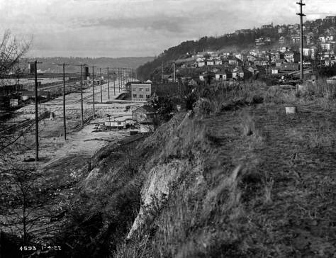
This is WAS the northwest “corner” of the hill since razed: Denny Hill. The difference in the elevations recorded here sometime in 1902 or 1903 and now was a mere one foot.  This part of the Denny Hill regrade along Second Avenue began in 1903.  It is a rare look into the neighborhood when it was still a hill.

A detail of the “North Seattle Neighborhood pulled from Seattle’s 1891 birdseye evocation.  The red arrow we inserted to-right points at the Wayne Row Apartments, southeast corner of Second Avenue and Bell Street.

John Hannawalt of Old Seattle Paperworks (still in the Pike Place Market) first showed it to me in the late 1970s. I was quickened. While I knew nothing about it I wanted it to be at least part of Denny Hill, the Seattle hill had been episodically removed between 1876 and 1931.  And it was. These two-plus blocks between Bell and Lenora streets were razed to their present elevations between 1903 and 1908.  With the photo in hand, finding the intersection came

The southeast corner of Second Ave. and Bell Street ca 1980.

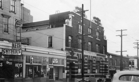
quickly, largely because I liked the bowls of beans, rice and cheese served at Mama’s Mexican Kitchen, still here at the southeast corner of this intersection.  Of course Mama was not in the Webster and Stevens Studio photo ca. 1902, but it was on my diet in 1978.

The southeast corner of the intersection copped to help one find the street sign nailed to the power pole.

With the help of a jeweler’s hand-held magnifying glass I soon found the street name “Bell” on the telephone pole at the corner.  Standing above the corner, both in the photo and on my visits to Mama’s, were the three gables of the Wayne Apartments, a row built in 1890 and wonderfully still standing. I first published my “findings” in the Seattle Sun and it was on the evidence of that discovery that this newspaper first engaged me to write this feature in 1982.

A typical tax-card from the late 1930s, this one concentrating on the row-house that is still standing at the southeast corner of Bell and Second..   CLICK TO ENLARGE

The “then” in this week’s “repeat” pair probably dates from the late 1930s or even 1940, the year that, city-wide, many of the street cars were replaced with buses or trackless trollies.

WEB EXTRAS

Anything to add, boys?  Some visits with a few friends from the neighborhood – extended.

THEN: Werner Lenggenhager's recording of the old St. Vinnie's on Lake Union's southwest shore in the 1950s should remind a few readers of the joys that once were theirs while searching and picking in that exceedingly irregular place.

THEN: Steel beams clutter a freshly regraded Second Avenue during the 1907 construction of the Moore Theatre. The view looks north toward Virginia Street.

THEN: An early-20th-century scene during the Second Avenue Regrade looks east into its intersection with Virginia Avenue. A home is being moved from harm's way, but the hotel on the hill behind it would not survive the regrade's spoiling. Courtesy of Ron Edge.

belltown-moran-then

THEN: The Dog House at 714 Denny Way was strategically placed at the southern terminus for the Aurora Speedway when it was new in the mid-1930s. (Photo courtesy of Washington State Archive, Bellevue Community College Branch.)

Montana-Horse-Meat-MR-THEN

THEN: Thanks to Pacific reader John Thomas for sharing this photograph recorded by his father in 1927. It looks north across Times Square to the almost completed Orpheum Theatre. Fifth Avenue is on the left, and Westlake on the right.

2nd-and-Blanchard-THEN

THEN: Louis Rowe’s row of storefronts at the southwest corner of First Ave. (then still named Front Street) and Bell Street appear in both the 1884 Sanborn real estate map and the city’s 1884 birdseye sketch. Most likely this view dates from 1888-89. (Courtesy: Ron Edge)

THEN: Built in the mid-1880s at 1522 7th Avenue, the Anthony family home was part of a building boom developing this north end neighborhood then into a community of clapboards. Here 70 years later it is the lone survivor. (Photo by Robert O. Shaw)

THEN: Looking southeast over the open acres of the Western Washington Fair Grounds following the matinee performance of Cheyenne Bill’s Wild West Show during the summer of 1909. (Courtesy, Old Seattle Paperworks)

THEN: Thanks again and again to Lawton Gowey for another contribution to this feature, this ca. 1917 look into a fresh Denny Regrade and nearly new “office-factory” at 1921 Fifth Avenue. (Courtesy, Lawton Gowey.)

THEN: An Emergency Relief Administration wood pile took temporary quarters on the southeast corner of S. Alaska Street and 32nd Ave. S. in 1934. (Courtesy, Northwest Collection, University of Washington Libraries.)

THEN: When it was built in 1902, this box home, with classic Ionic pillars at the porch, was set above the northwest corner of the freshly graded Brooklyn Avenue and 47th Street in the University District.  (Courtesy, John Cooper)

THEN: Like violence in a classic Greek play, the carnage suggested by this 1934 crash scene on the then new Aurora speedway was kept off stage, either behind the city’s official photographer, or in the county morgue.   (Courtesy, Seattle Municipal Archive.)

THEN: St. Vincent de Paul’s first storefront opened in 1926 in Belltown’s grand clapboard hostelry at the corner of First and Battery.  Originally the Bellevue Hotel, it’s reduced here to the “house keeping and transient rooms” of the Bay State Hotel.  (MOHAI)

THEN: From boxcars and rooftops to the planks of Railroad Avenue, excitement builds for the ceremonial re-enactment of the S.S.Portland’s 1897 landing with its “ton of gold” on the Seattle waterfront, the city’s first Golden Potlatch Celebration.  [Courtesy, Michael Maslan]

KENNY-HOME-then-mr

THEN: A carpenter’s jewel with Victorian ornaments recorded by a tax assessor’s photographer in 1936, nestles at 615 Eastlake beside the surviving Jensen Apartments, aka the O’Donnell Building, on the left. (Courtesy Stan Unger)

THEN: The ‘Seattle showplace’ Rhodes mansion on Capitol Hill, ca. 1916. (Courtesy, Museum of History and Industry)

THEN: James P. Lee, Seattle’s busy public works photographer of the early 20th century, recorded this 1922 look north from near the west end of Denny Way on the bluff above the then-forming Elliott Way. (Courtesy Museum of History and Industry)

THEN: Looking west (not east) on Battery Street from Seventh Avenue, approaching the end of the last of Denny Hill’s six regrade reductions. The dirt was carried to Elliott Bay on conveyor belts like the two shown here. (courtesy Seattle Municipal Archives)

THEN 1: Recorded on April 14, 1928, about sixth months before the Denny Hill Regrade No. 2 began, the last of the scarred Denny Hill rises to the right of Fifth Avenue. Denny School (1884) tops the hill at the northeast corner of Battery Street and Fifth Avenue. On the horizon, at center, Queen Anne Hill is topped by its namesake high school, and on the right of the panorama, the distant Wallingford neighborhood rises from the north shore of Lake Union. (Courtesy, Seattle Municipal Archives)

THEN: Lawton Gowey looks north through the tail of the 1957 Independence Day Parade on Fourth Avenue as it proceeds south through the intersection with Pike Street. (Courtesy, Lawton Gowey)


Leave a Reply

This site uses Akismet to reduce spam. Learn how your comment data is processed.