THEN: Included among the several detailed photos taken for the Bernards of their new and yet rustic Fir Lodge, was this one of the living room with its oversized fireplace and the piano on which Marie, their older daughter, learned to play well enough to concertize. (Courtesy Doris Nelson)NOW: Southwest Seattle Historical Society supporters Annie Tigtig and Kippy Jo Alexander (seated) pose with director Clay Eals for Jean Sherrard beside the charred Homestead’s fireplace. One of the mysteries of Fir Lodge/Alki Homestead is why the original fireplace was enlarged with the rock crown added in the mid-1930s. One of the puzzles of landmark preservation, and for the new owner-restorer, is should the living room hearth be returned to its former glory or be kept with this dark rock corona?
The well-connected Gladys Barnette and William Bernard started their thirty-two years of married life in the Olympia mansion of Washington state’s first governor, Elisha Ferry. That is, they were married there in 1892. About ten years later the Seattle couple began spending part of their summers on Alki Point, when it still took a steamer or a ferry ride followed by a long walk to get there. The first Midwestern farmers had landed there fifty years earlier, with enterprising intentions of building a city, although they soon fled Alki Point for Piners Point, known now as the Pioneer Square Historic District.
While not the first Bernard communion with Alki Point, Driftwood Camp is a typical for the time creation at the Point, canvas stretch tight over a sturdy frame set on a plank foundation and facing the beach. This first appeared in Pacific on Jan. 9, 2000.The earliest clip about Fir Lodge, the Bernard home, published in The Times on Aug. 19, 1906.
When first vacationing on the Point, the Bernards rented one of the well-wrought and framed tents and furnished it first with Persian rugs spread on a carpentered frame. They soon bought the block extending south from Alki Beach along the west side of Southwest 61st Street and hired Seattle architect Fred Fehren to design for them a rustic and yet baronial log lodge. The couple who founded the Seattle Soap Company, the city’s first, was skilled at both real estate and manufacturing. The Bernards could afford their new Alki home, which they named Fir Lodge.
Something about Fred Fehren, pulled from “Shaping Seattle Architecture,” the University Press history of local architecture, which has recently been republished with a second and enlarge edition. CLICK TO ENLARGEClip from The Times for Sept. 21, 1950.The Stockade near Alki Point.
Built in 1903-04, the lodge was one of the two largest structures on the then still sparsely settled Point. The other, the nearby Stockade Hotel and chicken dinner resort, was built by their friends, Alfred and Lorena Smith. It also was constructed of logs “harvested” off the Point, and both of these Arcadian creations had oversized fireplaces built of beach stones. The Bermards bought their block from the Smiths, because Lorena’s parents, the Hansons, had purchased the entire Alki Point in the late 1860s from Doc Maynard, one of Seattle’s original pioneers. This was, and is, historic ground.
First appeared in Pacific, July 24, 1988.
For reasons that are still a mystery to Alki Point historians, the Bernards, after three years of hosting well-appointed parties on the open veranda of their log palace, sold it in 1907 to the then fledgling Seattle Auto Club. After the motorists decamped from the Point in 1911, the lodge served as a residence. In 1950 it opened as a restaurant, the Alki Homestead, which brings us to its scorching and closure in 2009. (See the Log Cabin Museum links on all that, which Jean has attached below.)
Another helpful Times clip, this one from June 30, 1907.A surviving log construction, Sea View Hall is off South Alki Beach. (First appeared in Pacific, Jan. 23, 2000)We have excerpted the part about the Bernards from Margaret Pitcairn Strachan’s feature on “Alki Point District, Seattle’s Birthplace” published in The Seattle Times on June 14, 1946.
This year Jean and I enjoyed the Southwest Seattle Historical Society’s 4th of July picnic on the patio beside the Society’s Log House Museum, a restored Carriage House that was part of the Bernards’ estate. Following the potluck, Clay Eals, the spirited executive director of the Society, led us into the damaged Homestead. He had the key and a light heart, too. After the fire the Homestead was left haunted for six-plus years by fears that the log landmark might be razed. Instead, it has been saved, and its new hands-on owner Dennis Schilling has begun the restoration. Now the Society has named its upcoming November 7th Gala, “Coming Home to Homestead.”
The West Seattle Herald’s coverage of the Alki Homestead’s opening, published on June 25, 1950. CLICK CLICK to ENLARGEFirst appeared in Pacific, May 19, 1985.By Price who was also responsible for Price Photo on Roosevelt, a film processor and server for many years. CLICK to ENLARGE.
WEB EXTRAS
Let me throw in a handful of photos that illustrate a few of our previous run-ins with Mr. Eals and his SW Seattle preservationists.
In 2010, a remarkable coalition of persevering preservationists collaborated to save the Homestead from demolitionIn June of this year, Clay assembled more than a thousand school kids to help celebrate the new beginning of the Homestead. I took this photo from atop a lift with a very wide angle lens.This past Fourth of July, we returned to mark the anniversary of ‘This Place Matters’Another interior from that same day; this one with Paul as grandeeFirst appeared in Pacific, April 10, 1994.
Anything to add, kids?
YUP and sticking to form, Ron Edge starts off with a few not-so-old features that are relevant to the Homestead and-or Alki. [Now Jean, Ron calls to explain that his home sitting high on a knoll overlooking Lake Washington has been a victim of today’s (Saturday morning) storm. So he is waiting for the electricity service to return, but has also learned that it will probably not be until 3 a.m. Sunday morning that he should hope for it. And so we will wait too on our Edge Links. WHEN THEY COME he will position them at the very bottom.
This is the third time was have touched on that landmark for a story, although the first use was long enough ago that we have scaned the clipping and attach it just above. There were five or more glossies of the Homestead from which that one was chosen. Once the Edge Links are up you will find many of the others by exploring their fea tures. Ron is also including at the bottom of this week’s eight chosen links a feature titled “Travels with Jean,” which will, we hope, inspire Jean to share some of the photographs he took on his recent visit to Europe with a cadre of about twenty of his students at HILLSIDE SCHOOL (See the “button” link above right for more on the Bellevue School where Jean teaches.) Berangere Lomont, who is, we hope you know, one of the principals behind this blog, helped out in France. And Jean has responded!!! And here, next, is BB.
Jean here. Let me hasten to add a couple of photos I took a couple weeks ago featuring our remarkable blog partner Berangere Lomont:
Berangere on the banks of the Dordogne in the town of BrantomeBeranger with her husband Denis Christophe – one of my favorite humans on the planet, incidently – perched on Beynac’s medieval castle walls high above the river
=====
FOUR TIMES CLIPPINGS of the BERNARDS’ TWO DAUGHTERS. First on with a fashionable sketch of their oldest, Marie (the concertizing pianist), followed by three of Billie, their youngest. (Billie was one of Ivar Haglund’s friends. He used to pick her up in his Ford convertible with a heated brick on the floor board to warm her feet.)
The caption identifying Marie Bernard is below the sketch. Pulled from The Seattle Times for Oct. 15, 1911. CLICK CLICKBaby Billie Bernard in The Times for Aug. 20, 1911.Billie Bernard in New York preparing to tour Europe with her mother. Appeared in The Times for Oct. 10, 1929, and so close to the market crash.Billie serving as the center base for a March 30, 1930 montage of Seattle Society women.
======
HERE FOLLOWS THOSE EDGE LINKS – WHEN THE POWER LINES ARE REPAIRED
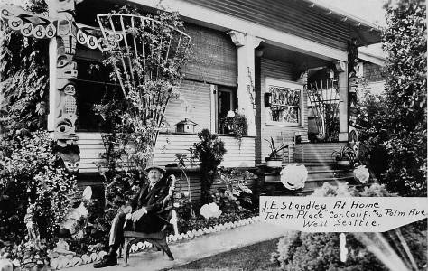
THEN: Totem Place, at 1750 Palm Ave. S.W., was home for Joseph Standley proprietor of Ye Old Curiosity Shop on Colman Dock. His death notice in The Seattle Times for Oct. 25, 1940 described the 86-year-old “Daddy” Standley as “almost as much a part of Seattle’s waterfront as the waves that dash against the seaweall.”Joseph James, “Daddy” Standley’s grandson, will welcome visitors next Sunday to Totem Place for “If These Walls Could Talk” Southwest Seattle Histoircal Society’s popular yearly program of opening homes for inspection and story-telling. The homes present owners Katy and Erik Walum will do some welcoming as well.A turned alternative photographed AT the same sitting, it seems.
Here sits Joseph ”Daddy” Standley, one of the best-known self-promoters in Seattle history, relaxing in a real photo postcard beside his West Seattle home. The caption pasted to the print on the right names the home Totem Place. The name also appears on the column to the left of the stairs decorated with potted plants and two large shells.
Bill Speidel: reporter, promoter, publisher – years before the Seattle Underground Tour. (S. Times)A Presbyterian pastor and a Knights Templar too, ca. 1925Ivar Haglund, the orientalist keeping both clam and cool.Daddy Standley standing with two of his totems and never once thinking “icons.”
Standley might be compared to three other local promotional players: Bill Speidel of the Underground Tours, Mark Mathews of First Presbyterian Church, and Ivar Haglund on Pier 54. All were accomplished storytellers and created most of their own publicity, largely by making themselves the news. “Daddy” Standley’s main stage, Ye Olde Curiosity Shop, was on the waterfront, where it remains in Ivar’s Pier 54 (soon to reopen, with a remodel and new seawall.)
On Colman Dock (Courtesy Waterfront Awareness)Daddy Standley somewhat earlier, known as “Curio Joe.”
The curio merchant’s life-long passion for collecting aboriginal artifacts is testimony to the importance of children’s literature. For having the “neatest desk” in his third grade class, young Joseph won a book about Indian life, lore, and crafts. The tome enchanted him so that ultimately the youthful anthropologist, to quote his namesake grandson, Joseph James, “turned his hobby into his business.”
I found this among prints left to me by an old friend, the sign painter Arthur Link Lingenbrink. Link had other photos of his “girl friend” – some arty figure studies included. Here, accompanying Link on one of his celebrity searches, she posed with Daddy in the late 1930s outside his Shop.
In 1899, the 45-year-old curio collector arrived in Seattle from Colorado with his wife and four children. In Denver he had operated a grocery store, with as much shelf space given to collectibles as to fruits and vegetables. After a few moves and name changes, Standley’s curious collections found a home on Colman Dock. In 1906 the family built a home in West Seattle on Duwamish Head with a clear view across Elliott Bay to Colman Dock with their shop, steamers and ferries.
Daddy’s grandson, Joseph James, posing at the former site of the Shop’s first home on Madison Street, near Western Ave. (see below)The first location for Ye Old Curiosity, on Madison near Western, ca. 1899. (Courtesy, the Shop and Joe James.)
Joseph James has taken his grandfather’s place for Jean Sherrard’s repeat and also for the upkeep of Ye Old Curiosity Shop’s traditions, both commercial and cultural. Joe grew up in Totem Place and remembers fondly how the house became a second museum for Standley’s collections. Its wide lawn was a sanctuary for his second passion, gardening. A sculpture garden for about fifteen large totem poles and a “six-foot high mound built with shells from the seven seas” were an attraction for both the children of the neighborhood and sight-seeing busses.
The Rubydeaux, one of the attractions for his children and their friends, which Daddy built on the big lot of Totem Place. The contemporary repeat (from 2006) is below.
Next Sunday, June 28, Totem Place again becomes an attraction when the Southwest Seattle Historical Society assembles there its experts, exhibits – including “totems on loan” – for “Ye Olde Home of Joseph “Daddy” Standley. It is this year’s offering for the Society’s annual event, “If These Walls Could Talk.” For details, call the Log House Museum at (206) 938-5293, or visit loghousemuseum.info.
We have superimposed Sylvester, one of the Shop’s ancient stars, onto Shop stationary from about 1940. Note the list of services/attractions on the left. [CLICK to ENLARGE]A wider view of Totem Place. Although blasted by back light both Daddy Standley, near the center, and his tall sculpture made of shells, far left, are apparent. (Courtesy John Cooper)
WEB EXTRAS
Anything to add, boys (and that includes Clay Eals)? BY GOLLY YES Jean, but not so timely, except if my excuse for being behind time might be found also in our subject: history. No way that we can fill in this blog by 3AM this Sunday morning. I must write the next Pacific feature for the Times by then as well. The research notes are abundant – too abundant, but what a delight to gather them. So hopefully tomorrow I will return and add to this many neighborly features that can be manufactured with a little scanning of clips.
=====
Scanned clips to follow – sooner than later, we hope.
THEN: The Seattle Times in its lengthy coverage of the then new Seattle Steel in the paper’s Magazine Section for Sept. 10, 1905 – the year this photograph was recorded – noted that “the plant itself is a series of strong, substantial, cavernous sheds, built for use, not for beauty.” (Courtesy, MOHAI, the Museum of History and Industry)NOW: For his repeat Jean Sherrard stood on the Youngstown neighborhood’s SW Yancy Street, a few feet east of SW Avalon Way, shooting north through an industrial park that in the 109 years separating the “then” from the “now” has grown in every available direction for the production of steel.
Here (at the top) is print number 12,920, preserved in the library of the Museum of History and Industry’s collection of historical photographs. Like many of the archive’s early prints, this factory scene is mounted with a generous border to protect it from ‘dog ears’ and other indignities. On the border of the stiff board, with the identifying number, is printed the caption: “Exterior view of Seattle Steel Company shortly after it began operation in 1905.”
The Seattle Times 1905 celebration of the city’s new manufacturer. (This printing is included for the design and not the reading – out copy is too small and smudged.)For comparison, another early look at the new Seattle Steel Mill beside Young’s Cover. This prospect looks to the northwest from near Andover Street and the outlet of Longfellow Creek into the tideflats of Young’s Cove. The tide is down. We note that his WS print is the same one used in the 1905 Times clip above. The Webster and Stevens (WS) studio was employed then to do the editorial photography for the afternoon newspaper. (Courtesy, MOHAI – an early print from their Webster Stevens Collection.)
The rising smoke and steam of the featured photo on top confirm that the superheated work of transforming the industrial scraps, piled here on the south side of the factory, into useable steel is underway. Much of it was rolled and stretched into bars used to strengthen concrete, like that used in Seattle’s first skyscraper, the then but one-year-old Alaska Building, which stands, both elegant and sturdy, at the southeast corner of Second Avenue and James Street.
A circa 1905 pan of the waterfront and business districts taken from the top of the Alaska Building when it was new. CLICK to ENLARGEThe Alaska Building at the southeast corner of Second Avenue and Cherry Street.William Pigott in his place, as rendered on page 180 of the 1906 book of sketches titled “Cartoons and Caricatures of Seattle Citizens.” Most likely this ambitious tome was not produced by a “vanity press” with its contents paid for by the book’s subjects. Pigot’s name is misspelled.
William Pigott, the factory’s founder, was variously described as a “devout Catholic” and “patriarchal capitalist.” As soon as Pigott announced his factory plans in 1903, the small neighborhood on the west side of Pigeon Point began to boom with mill workers moving into new but modest homes. Pigott first named it Humphrey after a town where he had earlier lived and worked with steel, but he soon changed the name to Youngstown, after another patriarchal company town with rolling mills in Ohio. Youngstown resisted
A clip from The Seattle Times for April 27, 1907 that elbows its way through some of the confusing complexities of injunctions and annexation in 1907. CLICK TO ENLARGE
incorporation into its much larger neighbor to the west, West Seattle. When Seattle did annex it in 1907, the unincorporated company town came along, most likely for the better sewerage and water. By then Youngstown supported four saloons and a public school, the latter built by the mill. The community also kept its eye on the frequently flooding Longfellow Creek that flowed and too often overflowed through it into Young’s Cove.
A Seattle Municipal Archive recording of the overflowing Longfellow Creek, recorded on Jan. 19, 1919. The view looks north towards W. Andover Street, which is here built atop a low trestle as is approaches the creeks outflow into Young’s Cove. [Courtesy, Seattle Municipal Archive]And early look west into Youngstown from near Avalon Way. Surely there are some bars among the businesses that line the south side of Andover Street. The Pigeon Point “heights” are on the horizon. The photograph was taken by A. Curtis, or his studio, circa 1908.Looking west from the dirt center of Andover that separates the wagon (or motorcar) planking on the left from the trolley tracks on the right. Here, about two blocks to the west, the company has built over the center-line of Andover Street a modest construction that resembles – at least – an office sited exterior to the plant proper, which here crowds Andover on the right. It is another prerogative of a “company town.” The subject is dated from “about 1920.”Like the subject directly above, this one also looks west on Andover, but also down on it form the neighborhood hotel. The view is date 1919, and by then Pacific Coast Steel’s Seattle plant was operating four open hearth furnaces. It was easily the largest steel-making facility in the Pacific Northwest. [Courtesy, MOHAI]The footprint of the yet-to-be-built steel plant copied from the 1904 Kroll map.
Drawn “from plans only,” a captioned footprint of the factory was printed in the1904 Kroll Seattle real estate map. The map names, left to right, the Stock House, the Heating House (with the smokestacks), the Rolling Mill, and running east-to-west, several attached wings named collectively the Run-out Building and Warehouse. Beyond these the Kroll map notes, “Tide flats, being filled in.” These Young’s Cove tidelands between Pigeon Point, on the east, and West Seattle, on the west, would be reclaimed and covered by the expanding factory. Longfellow Creek is now carried to Elliott Bay via a culvert beneath the fill.
Marked “1953” with a post-it at the top in Elliott Bay, here far below we find the crowded steel mill filling Young’s cove a mere half-century since Pigott devised his plans and began rounding up and purchasing permits and real estate to build Seattle Steel. The mill is below the subject’s center, and also below Spokane Street, which comes from the far right where it crosses the West Waterway before passing below Pigeon Point, wrapped in its greenbelt, lower-right, on its way to West Seattle, on the left. Note the verdant acres, bottom-center, where Longfellow Creek passes through the Youngstown neighborhood as far as Andover Street. From there the creek has been redirected to reach Elliott Bay thru covered culverts.A detail from a 1909 map of Seattle marking both Youngstown and Youngs cove. Seattle Steel is noted with its footprint. [Courtesy, Greg Lange]The plant and the neighborhood in a detail pulled from the 1912 Baist Real Estate Map. Note how the tideflats of Youngs Cove have been drawn for sale, reclamation and development – to and by the steel manufacturers.
Many years ago I first featured Seattle Steel in the Pacific Northwest Magazine. Here’s a clip of it from the Sunday Times.
Pacific Northwest readers may recall the Pacific Magazine’s recent May 25th cover story on this factory. See it online at http://bit.ly/1y2SKBF. Or click on the next image below.
WEB EXTRAS
Anything to add, Paul?
Yes Jean, and some of it is inserted above your request – or will be – illustrating this week’s text itself. As for LINKS there is but one this week, and it reaches back merely a few weeks to the feature SPOKANE STREET from WEST SEATTLE. Ron Edge will put it up next. If explored, this single link will lead the dedicated reader to many more features – more than twenty of them – that relate to the neighborhood widely considered.
=====
FOLLOWS
I found the prints below while doing research for a legal case years ago. It had to do with responsibilities following damage from the flooding of the Longfellow Creek across Andover Street and into the industrial park, lighted like the inferno and spreading harrowing noises, now run by Nucor Steel Seattle. The prints were all part of an exhibit, which, I figure, was shown at MOHAI, for it is, after all, a museum for both history and industry.
Pacific Coast Steel, about 1915 and after the large additions, left-of-center, were in place, reaching Andover Street on the far right. Youngs Cove is still visited by the tides, and the photograph was taken over the Longfellow Creek outlet, and looking west to a West Seattle skyline that still mixes tall trees with new homes. (Courtesy, MOHAI)This dark interior of the early plant’s 12-inch rolling mill dates from about 1910. We can imagine the mix of warm light from the furnaces with the cool blue light falling from the mill’s high windows.
Ingots – all in a row – are here top cased in the open hearth pit, which was first opened soon after Pacific Steel too over Seattle Steel in 1911. [Courtesy, MOHAI]An early crew at Seattle Steel takes a break from its heavy labor at the rolling mill. [Courtesy, MOHAI]An example of the scrap steel – on top – that is turned into ingots – at the bottom – with the help of great heat and the men in the middle. These, however, are not from Seattle or Pacific or Bethlehem Steel, but from a smaller Seattle competitor, Northwest Steel. [Courtesy MOHAI]Work on constructing a factory “shed” to house a new rolling mill. Dated 1920, by then Pacific Coast Steel’s Seattle branch was the largest steel making facility in the Pacific Northwest. [Courtesy MOHAI]Bethlehem Steel purchase Pacific Coast Steel late in 1929, the year, also, of William Pigott’s death and the start of the Great Depression. South (left) of Spokane Street there is nothing tidal in Youngs Cove to be found here. [Courtesy, MOHAI]Another aerial of Bethlehem Steel, this one looking to the southeast with Spokane Street on the left. It is dated tentatively ca. 1955. Avalon Way is bottom right, and the climb on Andover east up to Pigeon Point is upper-left. The building on the right, with the five mostly smoking stacks, housed the open hearth furnaces where scrap steel was transformed into “new old steel.” Soon after this aerial was recorded the plant would be closed for installation of electric steel making equipment, in 1958. [Courtesy, MOHAI]Steel framework in place during the construction of the electric furnace building in the late 1950s when two 100-ton units were installed, doubling the plant’s annual ingot capacity from 250,000 to 500,000 tons. [Courtesy MOHAI]The lid is opened on a new electric furnace to accept its first “charge of scrap” in the company of men in hardhats and, it appears, some suits. [COURTESY MOHAI]The MOHAI caption for this print expresses itself. “Always a dramatic sight . . . steel poured from an electric furnace at Bethlehem’s Seattle Plant.” [Courtesy, MOHAI]In 1972, Bethlehem built this “baghouse” air pollution control system adjacent to the electric furnace shop. [Courtesy, MOHAI]
THEN: In 1852 many of Seattle’s first pioneers removed from Alki Point by dugout canoe for the deeper and safer harbor along the east shore of Elliott Bay (our central waterfront). About a half-century later any hope or expectation that the few survivors among these pioneers could readily visit Alki Beach and Point by land were fulfilled with the timber quays and bridges along Spokane Street. (Courtesy Seattle Municipal Archive)NOW: The undulations and elevations required to lift Spokane Street high above the waterways and railways are evident in the Jeanette Williams Memorial Bridge (aka West Seattle High Bridge), barely seen just left of its west end extension with the ascending Fauntleroy Expressway on the right.
Across the tidelands of Youngs Cove, here at low tide, is Pigeon Point. From central Seattle Pigeon Point is a headland that often blends in with the greater mass of West Seattle and its pronounced Duwamish Head. On the far right, looking over part of the Seattle Steel plant, is a glimpse into the Youngstown neighborhood.
Here Pigeon Point and West Seattle have sorted themselves out with the aid of atmospheric perspective. The point is the darker headland entering the subject from the left. The featured text for this look west to Pigeon Point and beyond it to West Seattle is included in the bundle of features grouped under the first of the three links placed following this week’s feature text.
Jogging through Youngstown, trolleys from Seattle first reached the west shore of Elliott Bay in 1907, the year of West Seattle’s annexation into the city. They came by way of a new swing bridge over the Duwamish River that was roughly in line with Spokane Street. After swaying around Pigeon Point, the electric cars turned south into Youngstown. From there the tracks turned north to Duwamish Head, reaching Luna Park on June 27thin time for most of the summer play. Built on pilings below the Head, Luna Park was the grandest of the many Alki Beach attractions that extended to Alki Point, which the trollies reached in 1908.
Spokane Street with the slight obstruction of Pigeon Point on the right. The prospect looks east from near 26th S.W. on Oct. 4, 1920.A detail from the 1912 Baist Real Estate Map with Spokane Street at the top and the Youngstown neighborhood at the bottom and south of Andover Street.With trolley track on the left, Youngstown’s “main street,” West Andover, looking east to Pigeon Point (with the Point out-of-frame to the left./north.) Courtesy, Lawton Gowey
By 1914 the circuitous route to Alki Beach previously running through Youngstown was straightened. The Spokane Street trestle had been recently extended west across the head of Youngs Cove, reaching West Seattle here at Admiral Way. Captioned at its lower left corner, the feature’s “top” subject’s long look east on Spokane Street was recorded on April 16, 1916.
A Seattle Times clip from April 30, 1916 reporting on the neighborhood’s activism for more trolley service.Looking northeast from Avalon to the point where the early – Oct. 23, 1913 – Spokane Street trestle reaches West Seattle. Courtesy, Seattle Municipal Archive
As evidence of Spokane Street’s development into a West Seattle funnel, city engineers counted the traffic using it between 5 am and midnight on one day in early November 1915. The partial list recorded that two-hundred-and-ninety one street cars carried 11,699 persons, 692 passenger automobiles carried 1,501 persons, 203 jitneys (taxis) carried 744 persons, and 155 horse-drawn vehicles carried 187 persons across the West Seattle Bridge.
A Seattle Times report on the city’s study of bridge traffic, Nov. 6, 1915.
In 1916, the year of the feature’s lead photograph, the West Seattle Commercial Club began the long campaign for a “high bridge” to West Seattle, with grades lifting the traffic above the railroad tracks. In 1929 the trestle shown here was replaced and Spokane Street lifted with fill. The concrete Fauntleroy Expressway, high-flying through Jean’s “now,” was added in the mid-1960s. After another high bridge rebuff from city council, The Times for April 22, 1978, polled West Seattle citizens on secession. A majority favored it.
A pull-page from The Seattle Times on Nov. 26, 1916. Click it – perhaps more than once.
In 1929 the trestle shown here (again, with the featured photograph) was replaced and Spokane Street lifted with fill.
A detail of the neighborhood from the city’s 1929 aerial survey. The “fattening” – but not the lifting – of Spokane Street as seen from high above. The scan is used courtesy, again, of Ron Edge who scanned it all: the entire city in 1929, the first such aerial hereabouts.With a glimpse of the steel mill on the far left, here Spokane Street is being reshaped and lifted above fill. The view looks west on July 11, 1929. (Courtesy, Seattle Municipal Archive)
A month earlier on June 6, 1929 looking east over the same Spokane Street approach to West Seattle (proper) with construction about to begin on new concrete ramps for the Avalon-Spokane-Harbor-Admiral nexus. Pigeon Point is on the right. (Courtesy, Seattle Municipal Archive)At least from my print, the full date, bottom-left, for this look into the construction on the new interchange is cut off. The view looks northeast. (Courtesy, Lawton Gowey)Blue lines, upper-left, on this ca. 1931 Sandborn Real Estate Map, mark the construction site on the Spokane-Avalon-Harbor-Admiral interchange.The ornamented and almost completed intersection looking east – asking to be compared to the featured photograph at the top.Below the same ramps (as those one image above) on April 26, 1930.
The concrete Fauntleroy Expressway, high-flying through Jean’s “now,” was added in the mid-1960s. After another high bridge rebuff from city council, The Times for April 22, 1978, polled West Seattle citizens on secession. A majority favored it.
The Fauntleroy Expressway gaining altitude above our and Lawton Gowey’s – the photographer – intersection on May 10, 1`968
Less than two months later, Capt. Rolf Neslund began the rescue of these angry neighbors from their jams and closed bridges on Spokane Street when his gypsum ship Chavez rammed the West Seattle bascule bridge beyond repair. The new high bridge – and heart’s desire – was dedicated on a windy November 10, 1983.
Well, in part. Here we learn from Clay Eals, West Seattle champion and director of its Log House Museum and all that is connected with it, that we are half correct on the date of completion for the high bridge. We quote Clay.
But you may say that a 30th anniversary doesn’t square with the Nov. 10, 1983, date at the end of your column — and it doesn’t. That’s because the high bridge wasn’t fully opened on Nov. 10, 1983. Only the eastbound lanes were opened on that date. The westbound lanes were opened July 14, 1984, making the bridge fully open then, hence the 30th anniversary.
Might you be able to change the Nov. 10, 1983, date to July 14, 1984, if not on the Times page then on yours?
Here is a pertinent paragraph of info, taken from the web link above:
“The high bridge didn’t open all at once. Following the ramming of the low-level bridge by the freighter Chavez on June 11, 1978, construction on the bridge began in 1980. Eastbound lanes opened to the public on Nov. 10, 1983, and westbound lanes opened on July 14, 1984.”
Clay Eals, just before the unveiling of the West Seattle totem pole, in his natural setting
WEB EXTRAS
Anything to add, Paul? Surely Jean. In the three features that Ron Edge has posted below with picture-links there is an array of past features that touch on subjects that themselves – most of them – touch on Spokane Street. Here is a general list for what one who clicks the links will find within “Coming Home to Riverside” and the last of the three, “Luna Park Entrance.” The second link is an Addendum to the first.
COMING HOME to RIVERSIDE
* A Riverside Family
* Six Bridges to Riverside (and West Seattle)
* Riverside Junction
* Spokane Street Trestle from Beacon Hill
* West Seattle Ferry at Colman Dock
* Fukii’s Bridge (to West Seattle)
* Elevated Railway on Marginal Way
* The “Shoe Fly” on the West Seattle Bridge
* Trolley Wreck on Spokane Street, Jan 8, 1937
* The Star Foundry, (on Spokane Street)
* Pigeon Point Fire Station No. 36
* Spokane Street Substation – 1926 (on Spokane Street)
* West Seattle High School (not on Spokane Street)
RIVERSIDE ADDENDUM
LUNA PARK ENTRANCE: Sept. 10, 2011
* Luna Park
* West Seattle Harbor
* How to Get to West Seattle
* West Seattle Ferry at Colman Dock
* Sea View Hall
* Halibuts Below Duwamish Head
* Novelty Mill
* Luna Park Below Duwamish Head
========
The THREE EDGE LINKS
1. Coming Home to Riverside
2. Riverside Addendum
3. Luna Park Entrance
=======
MORE FOSTER KLEISER BILLBOARD SURVEY EXAMPLES – with once exception for comparison. All are on Spokane Street an all come with their own captions, which are coded-described in order to put the sign company’s billboards in their proper places for potential clients to imagine their own message. In many of the original negatives for this collection, the billboards have been whited-out so that when the negatives are printed the prints appear without content, the better to imagine your own.
Looking west on Spokane Street a few blocks east of the 1929/30 work on the ramps into Spokane’s intersection with Avalon, Harbor and Admiral Way. Although well-stocked with ads, this is not from the billboard company’s collection but is used courtesy of the Seattle Municipal Archive.
==========
A SOLEMN CALL FROM THE RAMPS – 1937
======
A TEST
The subject below looks west not on Spokane Street but on James. That is Trinity Episcopal on the right at 8th Avenue. I am cleaning up and clearing out old stuff and this is one of many hundreds of screened prints – prints exposed through a half-tone screen for off-set printing – I discovered on a bottom shelf in one of my archival cubbies. It was probably printed in the early 1980s for possible inclusion in “Seattle Now and Then, Volume One.” I am testing it here to determine if its like the other screen prints found might be recycled with some tweaked scanning.
Included here as a text to determine if a screened print (made of little black dots) might be scanned for on-line use without interference. Click it to see if it succeeds or flops.
THEN: The Gatewood Craftsman Lodge was built on a road, in a neighborhood, and near a public school all named for the developer Carlisle Gatewood, who also lived in the neighborhood. The three women posing in the third floor’s open windows are the Clark sisters, Jean, Dorothy and Peggy, members of the family that moved into the home in the late 1930s.NOW: For his “repeat” Jean has posed replacements for the Clark Sisters in the top-floor open windows. House researcher Bethany Green holds her dog Lily at the center, Margaret Hayes, the lodge’s present resident, now for thirty years, is on the right, and Margaret’s niece Sarah Barton is on the left. Sarah also manages The Gatewood Bed and Breakfast. Margaret explains, “The only way to keep it is to let it sustain itself.”
This grand three-floor West Seattle lodge-size home with a rustic porch and veranda looks west from about 350 above Puget Sound and six irregular blocks west of the highest point in Seattle. (If you should wish to visit Seattle’s summit you will find it unmarked in the alley between 35th and 36th Avenues Southwest, south of the Water Dept. standpipes on Southwest Myrtle Street. At about 522 feet high, the alley transcends Queen Anne Hill by more than fifty feet.)
The address here is 7446 Gatewood Road S.W., which runs at a slant through the hill’s otherwise generally compass-conforming grid of streets and avenues. Most of these are crowded with homeowners who respect their neighbors open views of the Olympics by landscaping their lots low. Here, however, on Gatewood Road the Olympics are rarely seen, except in winter from the bedroom windows on the third floor. The home is nestled in the shade of one of the clinging greenbelts that interrupt the open sweep of the hill. Only a bird’s call away, the Orchard Street Ravine climbs the hill. It is one of the verdant West Seattle watersheds protected as a Park. By testimony of those who have lived here, the effect is like living in a park,
Surely a good sampling of the residences on this graceful western slope of West Seattle are homes with big families, but few of them also have eight bed rooms like this one had in 1910 when the English/Canadian couple, Francis John and Pontine Ellen Harper, built it for themselves, their five children, John, Frances, Macdonald, Cecil and Margaret, and more. A different Margaret, Margaret Hayes, the present owner since 1987, was told that there were sixteen living in the big house in the beginning.
Five families in all lived and paid taxes here through what the Southwest Seattle Historical Society calls The Gatewood Craftsman Lodge’s 104-year history. Representatives for all of them will be on hand next Sunday June 22 when the Society joins the present owner as interpreting hosts for another of the Society’s annual and enlightening home tours titled “If These Walls Could Talk.” The point is, of course, that next Sunday they will be talking. The public is invited to this fund-raiser. (For details call the Log House Museum at 938-5293.) We give special thanks to the “house history” done by Bethany Green and Brad Chrisman, whom Clay Eals, the Society’s director calls the “core of the home-tour committee this year.” In Jean’s repeat, Bethany is holding her dog Lily in the third floor window.
WEB EXTRAS
Anything to add, Paul? A few this evening and perhaps a few more tomorrow. First, again with the help of Ron Edge, we will grace the below with some links of other West Seattle stories pulled from features of the past. Then we will draw on some recent works of the Log House Museum and its energetic director and our by now nearly old friend, Clay Eals. After all that I’ll put up a few more of the by now many features on West Seattle subjects that we have published in Pacific since we started in the winter of 1982. There may be – again & again – some repeats. This week we will spare our readers the music analogy for these repetitions and variations. And Jean may your Hillside theatre dress rehearsal this Sunday afternoon and next weekend’s performances go well, this in your, well, what anniversary of starting these productions on Cougar Mountain?
=======
Towards the rear, Director Clay Eals with his red shirt and tie of many colors looks over the Totem Unveiling ceremony like the guardian angel he is.
The LINKS that follow come from the Southwest Seattle Historical Society, greater Seattle’s most vibrant of neighborhood-based heritage groups. HERE FOLLOWS with Links a letter we received from Clay Eals its directory this afternoon.
Dear Jean and Paul
Tomorrow’s “Now and Then” is stellar. Saw the printed bulldog edition. Thanks again. The event is not tomorrow but rather the following Sunday, June 22, and it will be helped immensely by your contribution.
[Oops! We gave the wrong address.] Don’t worry about the address. It’s only two digits off (should be 7446, not 7448), but there is no home even close to 7448. The closest one is 7228. So there will be no real confusion.


![A Seattle Municipal Archive recording of the overflowing Longfellow Creek, recorded on Jan. 19, 1919. The view looks north towards Andover Street, which is here built atop a low trestle as is approaches the creeks outflow into Young's Cove. [Courtesy, Seattle Municipal Archive]](https://i0.wp.com/pauldorpat.com/wp-content/uploads/2014/08/x-flood-1919-jan-19-andover-flood-4.jpg?ssl=1)


![Like the subject directly above, this one also looks west on Andover, but also down on it form the neighborhood hotel. The view is date 1919, and by then Pacific Coast Steel's Seattle plant was operating four open hearth furnaces. It was easily the largest steel-making facility in the Pacific Northwest. [Courtesy, MOHAI]](https://i0.wp.com/pauldorpat.com/wp-content/uploads/2014/08/5-looking-west-over-andover-street-to-the-steel-plant-with-the-west-seattle-horizon-beyond-it-the-view-dates-from-1919-by-then-at-the-end-of-world-war-i-four-open-hearth-furnaces-w.jpg?ssl=1)


![A detail from a 1909 map of Seattle marking both Youngstown and Youngs cover. Seattle Steel is noted with its footprint. [Courtesy, Greg Lange]](https://i0.wp.com/pauldorpat.com/wp-content/uploads/2014/08/x-map-1909-youngs-cove001-copyweb.jpg?ssl=1)


![Ingots - all in a row - are here top cased in the open hearth pit, which was first opened soon after Pacific Steel too over Seattle Steel in 1911. [Courtesy, MOHAI]](https://i0.wp.com/pauldorpat.com/wp-content/uploads/2014/08/6-ingots-cased-in-the-open-hearth-pit-ca1914-web.jpg?ssl=1)
![An early crew at Seattle Steel takes a break from its heavy labor at the rolling mill. [Courtesy, MOHAI]](https://i0.wp.com/pauldorpat.com/wp-content/uploads/2014/08/7-crew-break-at-the-120inch-mill-at-seattle-steel-web.jpg?ssl=1)
![An example of the scrap still - on top - that the men with tongs - at the middle - turn into ingots - at the bottom - with the help of great heat. [Courtesy MOHAI]](https://i0.wp.com/pauldorpat.com/wp-content/uploads/2014/08/7b-northwest-steel-rolling-mill-seattle-scrap-ingots-tooweb.jpg?ssl=1)
![Work on constructing a factory "shed" to house a new rolling mill. Dated 1920, by then Pacific Coast Steel's Seattle branch was the largest steel making facility in the Pacific Northwest. [Courtesy MOHAI]](https://i0.wp.com/pauldorpat.com/wp-content/uploads/2014/08/5b-1920-construction-of-building-to-house-rollingmills-pacific-cost-steel-coompanys-seattle-plant-was-by-then-the-largest-steelmaking-facility-in-the-pac-nw-web.jpg?ssl=1)
![Bethlehem Steel purchase Pacific Coast Steel late in 1929, the year, also, of William Pigott's death and the start of the Great Depression. South (left) of Spokane Street there is nothing tidal in Youngs Cove to be found here. [Courtesy, MOHAI]](https://i0.wp.com/pauldorpat.com/wp-content/uploads/2014/08/8-aerial-k-nw-in-1930-when-bethlehem-puchased-the-pacific-coast-steel-coweb.jpg?ssl=1)
![Another aerial of Bethlehem Steel, this one looking to the southeast with Spokane Street on the left. It is dated tentatively ca. 1955. Avalon Way is bottom right, and the climb on Andover east up to Pigeon Point is upper-left. The building on the right, with the five mostly smoking stacks, housed the open hearth furnaces where scrap steel was transformed into "new old steel." Soon after this aerial was recorded the plant would be closed for installation of electric steel making equipment, in 1958. [Courtesy, MOHAI]](https://i0.wp.com/pauldorpat.com/wp-content/uploads/2014/08/4-aerial-ca1955-lk-se-over-bethlehem-stee-web.jpg?ssl=1)
![Steel framework in place during the construction of the electric furnace building in the late 1950s. [Courtesy MOHAI]](https://i0.wp.com/pauldorpat.com/wp-content/uploads/2014/08/9-steel-framwork-for-electric-furnace-building-late-50sweb.jpg?ssl=1)
![The lid is opened on a new electric furnace to accept its first "charge of scrap" in the company of men in hardhats and, it appears, some suits. [COURTESY MOHAI]](https://i0.wp.com/pauldorpat.com/wp-content/uploads/2014/08/10-first-charge-of-scrap-into-1of2-new-electric-furnaces-ca-1958-web.jpg?ssl=1)
![The MOHAI caption for this print expresses itself. "Always a dramatic sight . . . steel poured from an electric furnace at Bethlehem's Seattle Plant." [Courtesy, MOHAI]](https://i0.wp.com/pauldorpat.com/wp-content/uploads/2014/08/11-heat-of-steel-poured-form-electric-furnaceweb.jpg?ssl=1)
![In 1972, Bethlehem built this "baghouse" air pollution control system adjacent to the electric furnace shop. [Courtesy, MOHAI]](https://i0.wp.com/pauldorpat.com/wp-content/uploads/2014/08/12-bethlehems-baghouse-1972-air-polluion-control-addition-web.jpg?ssl=1)


WEB")
![8.-FK-SPOKANE-ST.-(SL-200'-E-of-26th-P-1)[Lk-e-to-Pigeon-Point]-R-176--Nov.-31,-1936-WEB](https://i0.wp.com/pauldorpat.com/wp-content/uploads/2014/06/8-fk-spokane-st-sl-200-e-of-26th-p-1lk-e-to-pigeon-point-r-176-nov-31-1936-web.jpg?ssl=1)


