THEN: The Mercer Arts Arena’s last hurrah was the exposure of the building’s four original front door Gargoyles. Two were saved and removed. (Courtesy: Museum of History and Industry, and its Post-Intelligencer Collection)NOW: With its new building on the Ice Arena’s old site, the Seattle Opera will have room for offices, storage, scene assembly, practice and whatever else beckons.This would probably be from the 1950s with considerable confidence if I had retained the “expert” status I had in high school on the names and years for all American-made autos. Surely some smart reader who has not let this aptitude slip will be able to name the year here from such a crowd of cars.
Jean Sherrard’s and my plans to photographically repeat the inside of Seattle Center’s Mercer Arts Arena (originally the Ice Arena) were interrupted by the recent decision to tear it down. The arena would seat about 5000 – when not flooded for skating. It was dedicated in 1928, and so by antiquarian standards did not qualify as “antique.” And yet in its mere 89 years, the Arena did manage to live within two skins.
This 1927 aerial shows the Civic Auditorium and Arena completed (more or less) and the Civic Field a work-in-early-progress. (Courtesy Ron Edge) CLICK CLICK to ENLARGE
The birthday suit of concrete dated from 1927 and showed some “Minimal Romanesque” ornaments like arched windows, decorative trim, and four gargoyles that faced Mercer Street above the Arena’s entrance. These adornments were subdued with Century 21’s architect Paul Thiry’s 1961-2 wrapping (also minimal) with bricks. They were laid for a modern polish thought more fitting for the “forward thrusting” Fair. The changes of course were not necessary for the Fair’s performers using the arena like Lawrence Welk, the Century 21 Horse Show, the Mormon Pageant, the Ringling Bros and Shrine Circuses, and the Ice Follies, to name a few.
David and Louisa Denny with their first two daughters.
The immigrant history for the future Seattle Center began in the 1850s with pioneers David & Louisa Denny. By the 1870s the young couple had nurtured a garden to feed their growing family and also much of Seattle. Beginning in the late 1920s Seattle’s Civic Center grew atop this garden. Its three largest structures, a sports field with covered bleachers, the Arena and the Auditorium – all of them labeled as civic – were bunched south of Mercer Street in what were formerly the Denny’s garden acres.
The Ice Arena on the right, the Civic Auditorium at the center, and Civic Field mostly hidden in the athletic pit beyond the wall on the north side of Harrison Street. (Note the man on the far right who appears to be looking at the lack of action on the field through a hole in the wall. Fourth Avenue is in the foreground. The PACIFIC published text for the above photo (the clip) is included below, just above Jean’s question “Anything to ad lads?” We put it there in anticipation of his question. (Courtesy, Municipal Archive)
The Center’s larger parts had all been nurtured from a modest grant bequeathed in the early 1880s when the Denny’s were still tending their gardens. The gift to the city was made by a gregarious bar owner named James Osborne. Over nearly a half-century this spirits’-borne endowment gathered a cash pile high enough to raise what the public house owner had wished for, a public hall owned by the public. The bonus legacy of the Arena was fitted with a floor for the center’s many “Ice Events.” These included amateur and professional hockey, gala ice shows, and extended hours of public skating like that recorded in this week’s featured photograph. Of course, there were skates to rent, instruction to be had, and organ music to accompany nearly a half-year of public gliding. At the start the floor was frozen five months a year.
The Arena offered skates for rental and expert help for the fitting. Courtesy The Times
The recent razing of the Arena did not raise much commotion. In his KIRO radio commentary, Feliks Banel, the station’s zestful historian, quote’s Seattle historian David Rash characterization of the Arena as something of an “orphan.” Rash points out what many others have sensed since Century 21, that the mix of the Arena’s uses – for the most part pop concerts and for the Seattle Opera convenient practice space – with storage – the Arena has had “no built-in constituency of regular users or devoted fans to speak up for it.” Banel notes, “It’s been offline for so many years.”
The Seattle Times caption for this reads, “Civic Arena, Skating for Charity – Verna Miles, left, of the Connaught Club, Vancouver, B.C., and Gloria Patrick, daughter of Frank Patrick, president of Pacific Coast Hockey League, in a skating number at the ice carnival given at Civic Arena last night for benefit of Children’s Orthopedic Hospital.
WEB EXTRAS
Let me provide a close-up detail from the ‘Now’ photo – above the arm of the yellow tractor, a last glimpse of the original seating:
Last view of the last arena seats
Anything to add, lads? Coitenly and silly too, Jean.
First published in The Times on November 14, 1993.
=====
MORE AREA ICE
When Ivar Haglund closed his aquarium on Pier 54 in 1956 he consoled those who wish it were not so with the reminder that one could always visit the Port of Seattle’s Frozen Fish Museum on the Port’s Spokane Street wharf.
=====
Ice skating on what remained of the captive pools on the tideflats.
=====
New skating rink for the Coliseum – minus the ice.
=====
Bitter Lake skating, January 15, 1930.
=====
Green Lake skating in 1903. South end with Woodland Park on the far shore.
=====
Masthead for Diamond Ice and storage at the waterfront foot of Union Street.
=====
Hopefully some of you will remember “Our Daily Sykes” the daily series of picturesque west coast Kodachromes snapped by Horace Sykes, a fire insurance claims adjuster and lecturer on fire safety. This subject, which he titled “Ice left after Columbia Cold Storage Fire, April 5, 1944.” is a rare instance of a work-related subject to be found among the thousands of mostly picturesque slides he left of the American West. You might, we hope, wish to find Sykes here again or for the first time. The daily series ran for 499 days. We stopped there so that we could later fulfill our promise for 500.
=====
On the church towers clue, far right, this ice house was once somewhere in the Rainier Valley.
=====
Union Ice Wagons (which, we suspect, means run exclusively by union teamsters, lined-up on Pike Street’s 200 block early in the 20th-Century. The numbers at the bottom may key to the drivers names, which, we assume (without seeing them) are written on the back of the original stiff-card professional photograph.
=====
=====While Puget Sound and much of the Pacific Northwest prepared for its Big Snow of 1916, these visitors to Juneau aboard the steamer North Western, were already ice-wrapped in Alaska. The date, January 25, 1916, is captioned on the face of the “real photo” postcard.
====
Another Frank Shaw 2&1/4 slide, this of the Pacific Science Center when it was ice-arrayed sometime in the 1960s.
=====
Back in Wallingford. Ice at QFC aka the old Food Giant. Ice Doors Open and . . .
=====
CLOSED
=====
Lighting ICE in my American Meter Machine studio in the late 1970s. It was a COOP with about a dozen artists with spaces on the top floor – at the southwest corner of Lake Union, across Westlake from the seaplanes. CLICK TO ENLARGE
THEN: The Japanese barque, Nippon Maru, visited Seattle during the summer of 1965. Here it shares the slip on the south side of Pier 56 with vessels of the Seattle Harbor Tours. (Photo by Lawton Gowey)NOW: The waterway between Piers 55 and 56 has been elaborately arranged to accommodate the growing fleet of Argosy Cruises (meaning “fleets of ships”), Harbor Tours’ name since 1994.
Intermittently, Kodachrome slides by Lawton Gowey may be expected with this weekly feature. Lawton was a good friend with whom I often compared and shared photographs. He began his clicking with his father before the second World War and continued exploring Seattle with his camera until his death in the mid-1980s. Lawton was both a creator and a collector, and Jean’s and my illustrated lectures – what we used to call “slide shows” – are elaborately enriched due to Lawton’s many interests, including this one of Seattle’s waterfront and its diverse navy.
ABOVE AND BELOW: Lawton Gowey’s enterprising records of an earlier visit of the Nippon Maru to Elliott Bay. In the top photo the sky seems to have sorted itself, a cloud for every sail. This and the front-lit exposure of the Nippon Maru that follows, Lawton dates June 20, 1962. Note the colors of the infant Space Needle to the right in the expansive portrait of the bark above.
Lawton Gowey has captioned this “bark Nippon Maru forward deck, June 28, 1965.” So the bark is about to leave the port.A clipping from The Times for June 22, 1965.The Times clipping showing directly above of this Alaskan Way subject makes note of four Nippon-Maru visits to Seattle, but dates only the Worlds Fair visit of 1962 in addition to the featured portrait from 1965. Here, it seems at least, is one more of the four. The top of the barque’s masts are seen reaching high above Pike Street Pier No.59 (now home for the Waterfront Aquarium), in 1957.
Lawton worked as an auditor for Seattle City Light, at the northwest corner of Third Avenue and Madison Street, about five blocks east up First Hill from this Elliott Bay slip between Piers 55 and 56 at the foot of Seneca Street. His office was an excellent prospect from which to keep an eye on the waterfront. It was Lawton’s helpful practice to consistently and clearly name and date his subjects on the borders of his slides; for the featured photo at the top the caption reads “The Nippon Maru, Pier 56, June 29, 1965.” It was the last full day of the Japanese training barque’s visit to Puget Sound before it returned to Tokyo by way of Honolulu. Capt. Isao Kieda, the ship’s master, thanked the 29,849 persons (by his count) who had boarded his ship during its stay. “My young cadets have been deeply impressed by your good will and kindness.”
The welcome-spouting fireboat Duwamish, can be seen out in the Bay here above the bow of the Harbor Tourist, Lynn Campbell’s waterfront tour boat. To of left the fireboat the Nippon Maru heads straight for Pier 56, the likely prospect for Lawton Gowey. Lawton dates this Kodachrome, June 22, 1965.A clip from The Times for June 30, 1965.The Harbor Tourist navy has here added The first (I think) of the Lynn Cambell’s Goodtime boats. Note the Seattle Aquarium sign (with the neon whale) at the end of Pier 56, and at the side of the warehouse the then very popular import shop, Trident. Take some time to read here below Trident’s curious promotion of its exotic service to the kitsch consumer.An intimate Greeting from Trident and October 9, 1962,
Parked to the reader’s side of the Nippon Maru in the featured photo at the top are two vessels belonging to Lynn Campbell’s Harbor Tours, long since renamed Argosy. Campbell was stocked with zest, and long-lived. Self-taught, he lectured his passengers on waterfront history or anything else that came up. Following WWII, he started a tugboat business hauling logs across Puget Sound that soon developed into the popular showman’s affordable and interpreted floating tours, most of them around Elliott Bay and/or between it and Lake Washington. Campbell’s daughter Charlotte, a wharf rat, was often aboard. She recalled that in the early 1950s, “This was a working waterfront. Train cars backed into docks. The bows of great ships loomed over our heads.” That soon changed.
The Seattle Times introduction of Campbell’s Harbor Tourist, from a 1953 clip, June the fourteenth. [CLICK CLICK ot ENLARGE]The bay-side end of Pier 56 showing the Marine Aquarium’s optimistic identification with the whale – any whale – before the 1965 capture of Namu.An early look to Pier 56 access to the Marine Aquarium and the waterfront’s helicopter pad.
By 1965, the year of the Nippon Maru’s visit, Seattle’s waterfront was well into its metamorphosis from traditional maritime work into a midway of cafes like the Cove and import curio shops like Trident – both seen here on the south side of Pier 56. Ted Griffin’s Waterfront Aquarium had opened on the bay-end of Pier 56 for the 1962 Century 21 World’s Fair. The general scramble hereabouts to fill the entertainment holes left by the Fair when it closed in the fall of 1962, included the ambitious Griffin’s aquarium followed in 1965 by his Namu. Griffin’s well-reported convoy pulled Namu, a net-caged killer whale captured in Alaska, down the inside passage to a new pen at the water end of Pier 56. Griffin paid for the prized critter out of a gunnysack filled with $8,000 in loose change he had gathered from friends and businesses on the Seattle waterfront. Along the way, news of Namu spread rapidly (and professionally), and an excited flotilla of naturalists, reporters, and happy hour celebrities formed, with nothing more pressing on their schedules than to follow a killer whale to Seattle.
Namu tanked at the water end of Pier 56.With Namu (and others) caged at the water end of Pier 56, the sidewalk beside Alaskan way became a promenade for protests, here against both the exploiting of whales and the indictment of the Seattle 7. (If you have forgotten the Seattle 7 you may wish to take it with you for keyword visit to Historylink, our state’s on-line encyclopedia of its history. Also the Washington State Press is on the verge of publishing a history of the Seattle 7. I read and loved a prep-copy of the book and learn much.
WEB EXTRAS
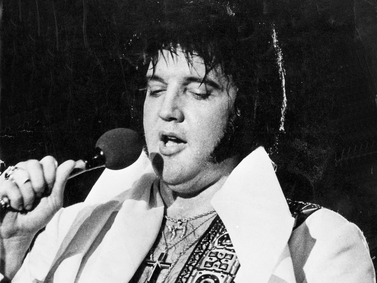
Anything to add, guys? Dearest Jean Randal Sherrard, and hoping I have got the spelling for you middle name correct. Ron Edge, I, and our readers – I’m confident – wish you a happy 60th Birthday – so Young! And so fit. Here we will insert a late photo of Elvis Presley that dates surely from before his death at the age of 42 in 1977. We will also hang from (or below) Elvis a photo of you about seven years ago (so around age 54) we’ve pulled from a promotional card for one of the many Rogue’s Christmases you have produced at Town Hall. And let the reader know that you look even better now, having lost many pounds at the hands of no one or nothing but your own diet that includes some nearly magic low-cal jello. And now you exersize as well – exploring the city for …
The late ElvisJean ca. 2010
… pictures at an exuberant and often enough joyful pace as you repeat – and re-repeat – 100 locations for the “Seattle Now and Then, Best Of” book that we hope to have completed and delivered to its readers sometime this coming October. And yet Dear Jean feel confident that should some other concern press upon you at school or somewhere else off the Cougar Mountain Campus of Hillside (dear reader, the school is described in a bug near the top) we can always postpone for a season or even a year. For now, though, we pause at the waterfront. Stay happy , healthy and salty – enough.
Here’s the topper – another happy mass of Edge Clippings of apt and old features.
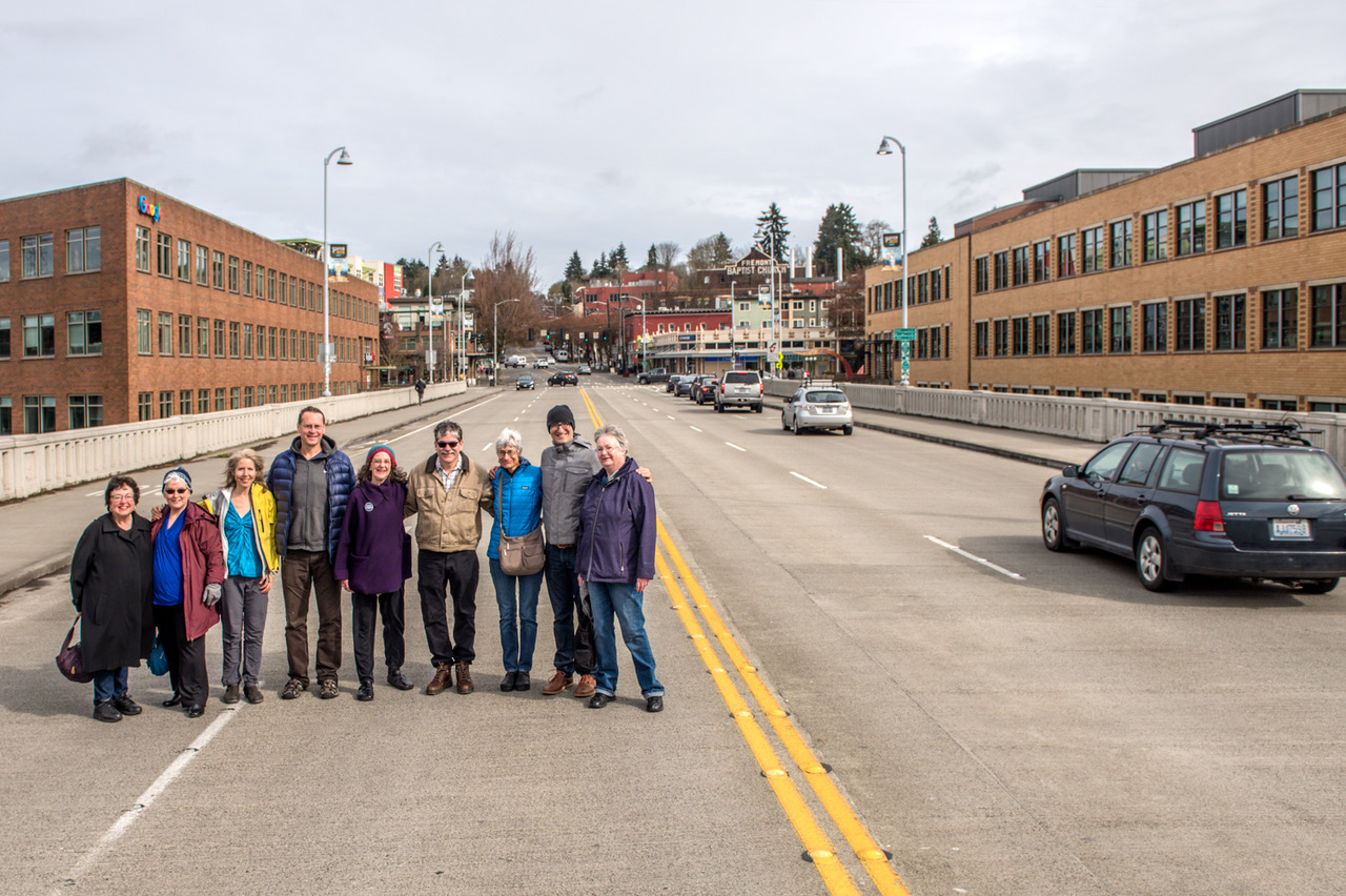
NOW: An uncredited photographer looks north on Fremont Street from its original intersection with Ewing Street (N. Northlake Way).NOW: Members of the Fremont Historical Society pose on the Fremont Bridge, prudently to the side of the busier northbound lane and also well ahead of the traffic advancing south from the 34th Street intersection behind them. Member Judie Clarridge, who helped arrange the “shoot,” stands on the far left side. She also advises that Valarie Bunn, far right, “does a good job about finding things” and was especially helpful in researching the featured photo. We should also note that Heather McAuliffe, the Society’s founder in 2004, is present and dressed in yellow and blue on the left. The Fremont Historical Society’s website is http://www.fremonthistory.org.
In line and alert, members of the Fremont Historical Society stand for Jean Sherrard’s “repeat” on the southbound lanes of the Fremont Bascule Bridge. The FHS members have just adjourned from their April meeting (the second Saturday) in the nearby conference room of the Fremont Public Library. The historians met in part to consider where to stand for the “repeat” of this week’s featured “then” and together study the inviting jumble of meanings included in the older photograph. The leading goals are, of course, to discover or uncover the “where” and “when” of the photograph, which, judging from the shadows, was recorded around noon. Although it came with no caption, the members easily knew, and in unison, that his was Fremont Avenue. They were less secure regarding its uncertain elevation. That will take more time.
Early during the members joint research someone noticed the sign exhibited, upper-left, in the second floor corner window of the clapboard business block. It reads “Mabel Canney, Piano”. Searches of city directories revealed that Mabel, and probably her piano, were located here in 1908 and 1909 but were then followed in 1910 by her younger sister Ella Mae. This, of course, strongly suggests that the Canneys were a musical family, but also that this subject looking north on Fremont Avenue was photographed sometime when one, or both, of the sisters was in residence there.
Details of downtown Fremont in details from the 1908 and 1914 (left and right) real estate maps of Seattle. (Courtesy, Ron Edge)The low Fremont Bridge looking north from the Queen Anne side in 1903A “real photo postcard” by Oakes looks north from the south slope of Queen Anne Hill (on 4th Ave.) to the Fremont Bridge at its old “low” level. Compete the retail storefronts lower-right to those in the later and first “high bridge” print that follows.An look across the temporary Fremont “high” Bridge on March 18, 1915. The attentive and/or clever eye will find here the top of the brick retaining wall that was built along the south side of 34th Street, It can be found between the two poles and one mill smokestack on the right and the bright white puff of steam right-of-center. There is also a larger and brighter part of the wall to be found on the left. Also the keen reader might wish to compare the grade of the businesses right-of-center with those in the earlier “low” bridge photo placed above this one. This is the “high” bridge repaired after the the center of its predecessor was swept away in 1914 when the dam at the Lake Union outlet broke, and lowered the lake by seven feet. The site of the broken dam seen from the temporary “high” Fremont Bridge in 1914. The pilings supporting the Stone Way bridge in the distance are awkwardly exposed by the sudden lowering of the lake.The low Fremont Bridge seen from the pedestrian bridge that crossed the Lake Union outlet at its dam ca. 1908.The Fremont dam and pedestrian bridge seen from the Fremont Low Bridge, probably in 1907. Note the distant standpipe, top-center, (near the subject’s center) of the Seattle Gas Company. It was brand new in 1907 and i\s now the site (of course) of Gas Works Park.The Fremont Bridge, looking southeast from the Fremont side in 1907. A pile-driver stands at the center.Looking southeast from the Fremont end of the “high” bridge repaired after the 1914 gush. The photo is dated March 3, 1915.The 1903 reconstruction of the outlet dam. Note that there is a yet no gas works on the Wallingford Peninsula. Dredging a Ross Creek Lake Union Outlet in 1903. Fremont’s lumber mill in on the left and Capitol Hill on the horizon. On might play hide-and-seek with the mill’s landmark stack. It can be easily found in several of the photographs above this one.
With the help and confirmation of other photographs, plus city maps – especially the real estate maps of 1908 and 1912 (as seen for inspection eleven photographs above) – and directories, the deliberating FHS membership could eventually calm the uncanny feeling that something was a kilter here. Through the years of building the Lake Washington Ship Canal, 1911-1917, there were big grade changes here.
A now-then feature looking north from the south side of Fremont Bridge in 1911. CLICK TO ENLARGE!!!First appeared in Pacific on June 22, 2003
In the featured photograph at the top in this first block south of the intersection of Fremont Avenue and Ewing Street, now 34th Street, Fremont Avenue was cut off and dropped below a retaining wall. In the process, both the mercantile building with the Canney piano on the left, and the mill warehouse on the far right, were settled to rest below the deck of the new but short-lived Fremont Bridge constructed in 1911-12. That was not the bascule bridge, which opened in 1917, but its penultimate span that reached N. 34th Street and the Fremont Business district at the new and still holding elevation. The investigating Society also discovered that the railroad track, which curves across the bottom of the subject, was kept to pass below the new Fremont Bridge. It was the Seattle and International Railroad spur that reached Fremont’s main employer, the Bryant Lumber Mill, to the right and behind the unnamed photographer.
Looking north along the north wing of Fremont’s bascule bridge on April 18, 1939.
WEB EXTRAS
Anything to add, lads? Yes Jean, those directly below that Ron Edge put up earlier this evening, and eventually a few more relevant features that I’ll pull from the archive after breakfast. It is 5:19 AM Saturday morning now, and I’m going to bed. Remembering now and in honor of Bill Burden its parent the kind good night “Nighty-Bears.” I climb the stairs.
THEN: A few of the landmarks revealed in this mid-twenties look north from the roof of the Medical Dental Building include Queen Anne High School, “Wilson’s Wood Row” of unused WW1 freighters camped in Lake Union, the Seattle Gas Company’s big holder at 9th and Republican, the Ford Assembly Plant and Denny Park. Can you find them? (Courtesy: MOHAI)NOW: The fenestration (window arrangement) of the glass curtain on the nearly new skyscraper at the northwest corner of Westlake and Virginia Street (to the left), is a fine expression of the growing revolt from the more minimal modern, like that used decades ago for the Plaza 600 Building at the center of this “repeat.” By comparison the new post modern – or post-post-modern – façade is psychedelic.
From his climb to the cornice of the eighteen-story Medical Dental Building, Jean Sherrard has thoughtfully returned with some frosting, one of the building’s crowning terra-cotta ornaments. Peeking at the bottom-right corner of Jean’s repeat, resembling a lampshade, it is one small part of the building’s elegant skin.
A 1925 clip from The Times
First imagined by its mix of professional (physicians and dentists) developers as a “real medical center in Seattle,” the polished and ornate Medical Dental Building was dedicated in 1925. With its ceramic tile cladding and more, the tower would be interpreted as an example of the late Gothic Revival, which, as it turned out, was a style about to lose its popularity.
In 1962, the Medical Dental Building rises behind the then new Monorail. The view looks north of 5th Ave. from mid-block between Virginia and Steward Streets. Photo by Frank Shaw
Looking north, from its tower, Westlake Avenue can be followed to Denny Way, where it elbows slightly to the northeast to complete its arterial duty to both Westlake and eventually Eastlake at the south shore of Lake Union. Westlake was sided by the triangular blocks and buildings fashioned in 1906-7 when it was cut through from Pike Street to Denny Way. Its landlords briefly named this new and direct approach to the north “The Big Funnel”.
North on Fifth Avenue from near Virginia Street and the front or south summit of Denny Hill, ca. 1886. The towered structured on the horizon is Central School (the largest in Washington Territory when it was built in 1884) facing Madison Street from its south side.
Jean’s thoughtful inclusion of the decorative ornament encourages us to extend our short review of the architectural history of this retail neighborhood at the north end of Seattle’s central business district. It began in earnest in the early 1880s with a few retailers scattered about the slopes of the by then clear-cut Denny Hill. The businesses were mixed with modest residences – some in rows – and tenements, all made from lumber milled on the shores of Elliott Bay and Lake Union. Aside from the built-for-show blocks around Pioneer Square and on Front Street (First Avenue N.) the fancier construction of this metropolis began only after its cinder-scrubbing by the Great Fire of 1889. Seattle began then to earnestly boom and build, often with bricks and the encouragement of better insurance rates for those who embraced both the new ordnances and bricks.
Capitol Hill from Denny Hill ca. 1893 about fourteen years before Westlake Avenue was cut through the grid here on its way from 4th and Pike to South Lake Union.
As for grace and style, terra-cotta tiles became nearly a necessity for any proud developer in the new twentieth century, until the expense of it became forbidding in the thirties with the Great Depression and/or too fussy for the more functional modernist tastes. One sizeable resister to modernity, “the Old Quarter,” appears here in the featured photo on left of Westlake and to this side of Denny Park’s greenbelt, also on the left. This is the last of the Denny Hill neighborhood. In 1911 it was left to molder when the Denny Hill Regrade reached Fifth Avenue and stopped. It remained dormant until 1929 when everything in this triangle was razed, including the low rents, just in time for the Great Depression.
A circa 1928 aerial of “old quarter – right-of-center – and the nearly new Medical Dental Building standing bright at the bottom-center with its own terra cotta tiled skin and Frederick and Nelson’s beside it to the south. Note the Civic Center’s construction scar upper right between Harrison and Mercer Streets and west of Fifth Avenue. (Courtesy, Ron Edge}
South on Fifth through Virginia Street. We don’t promise that the above now-and-then are perfect for repeating, but they are close.
Click to ENLARGE for Reading.The Medical Dental building endures on December 7, 1968 with protestors marching below it and the Monorail for citizens to “Remember the Pueblo.” Do you?
WEB EXTRAS
Anything to add, boyos? Sure Jean and by now we know the march. Ron Edge and I put up a sturdy parade of part features that relate to the week’s primary subject or concern or thereabouts. (Here I had hoped to include the original latin for “Repetition if the Mother of All Learning” but my computer has lost my “Google Translate” capacities. For the moment.)


![THEN: From boxcars and rooftops to the planks of Railroad Avenue, excitement builds for the ceremonial re-enactment of the S.S.Portland’s 1897 landing with its “ton of gold” on the Seattle waterfront, the city’s first Golden Potlatch Celebration. [Courtesy, Michael Maslan]](https://i0.wp.com/pauldorpat.com/wp-content/uploads/2015/07/potlatch-watch-above-railroad-ave-now-mr.jpg?resize=474%2C365&ssl=1)


-mr-THEN")