Seattle Now & Then: Second and Columbia, 1886

(click to enlarge photos)

THEN: Both of this week’s featured photographs were recorded from the same elevated prospect, but by different professional photographers: T. E. Peiser and D.R. Judkins. The latter’s can be identified by the studio sign that rises high, far left on a post at the southwest corner of Second Avenue and Columbia Street. Both photos date from 1886, and include different cues: the one of uniformed Knights of Pythias member-musicians marching south on Second and the other for the most part of primary students posing on the boardwalk. Both photographs also include, right-of-center, the home built by J.T. Jordon, Seattle’s second mayor, at the northeast corner of Second and Columbia, and left-of-center at the northeast corner of Second and Marion, the Stetson-Post Terrace, Seattle’s first swank apartments designed for its first ‘1 percent.’
NOW: Jean Sherrard has used his extension pole to approach the elevation exploited by the two pioneer photographers on the second floor of a neighbor’s home on the west side of Second Avenue.

Pioneer photographs of any Seattle street other than Mill Street (Yesler Way), Commercial Street (First Ave. S.), and Front Street (First Ave. north of Mill Street) are rare.  Here are two exceptions.  Both are on Second Avenue and both were recorded from the same prospect – within inches of one another.

In the 1880s pioneer photographers Theodore E. Peiser and David Judkins set up studios a block apart on the west side of Second Avenue.  They were competitors and almost certainly did not plan this propinquity.   Peiser’s studio was on the second lot south of Marion Street and Judkins’ on the southwest corner with Columbia Street.  The two professionals photographed parades of different sorts near their studios on Second Avenue, and only about six weeks apart.

I am long familiar with Peiser’s May 13, 1886 record of parading members of the secret society Knights of Pythias pausing for his professional snap. As a pioneer classic it has appeared often in publications and exhibits.  We used it for its own “now and then” in PacificNW on January 17, 1999. (see above)  Judkin’s photo, (2nd from the top) however, I had never seen before last week.  I was thrilled.

Nearly the same prospect looking north on Second from between Cherry and Columbia Streets, although recorded a quarter-century later during the 1912 Golden Potlatch Celebraton.

The alert Ron Edge discovered it while helping the Museum of History and Industry scan some of its oldest prints. The print of Judkins’ line-up of primary school children – about 200 of them on the east side of Second Avenue filling the block between Columbia and Marion Streets, and more – is dated June 23, 1886.

Handwriting on the back makes a claim for Emma Blocksom.  It is her “school picture” and Emma is probably one of the posing 200 or so.  The Blocksoms are listed once in the 1886 city directory, below,  living on Washington Street.  The promising family lead stops there. (And for us, now, as well.)

Seattle opened Central School in 1883 four blocks up First Hill from here. Central School was big enough to handle as many scholars, and more, as those lined up. Perhaps this late June day is the last before summer vacation for these students, and taking one school picture is certainly more efficient than several.  (In 1886 Seattle’s population of school-age citizens between four and twenty-one years old was 2,591.)

Central School, the impressive white box with a tower seen here, sat on the south side of Madison Street, between Sixth and Seventh avenues. This view of it was recorded ca. 1886 from near the corner of Ninth Avenue and Columbia Street. It shows how to the east of 6th Avenue First Hill nearly leveled off, pausing in its climb. Later in the 1960s this interruption became a more convenient topography for building the Seattle Freeway [Interstate-5).
Central School looking north from near Mill Street (Yesler Way) in the mid-1880s.  Apparent here, again, is the pause in First Hill’s climb east of Sixth Avenue. Seventh Avenue is on the right.

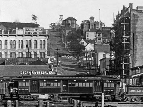
What is not explained for either of these pros is how did they lift or carry their heavy cameras so high above the boardwalk?  Here I am again thankful for help from Ron Edge. In the MOHAI collection off older prints, Ron found an 1887 panoramic look from Denny Hill that includes an unobstructed sighting down Second Avenue. While it is soft on focus, it still shows many of the landmarks included here.  Most importantly, the leafy tree near the northwest corner of Second and Columbia, on the left in both of the featured photos, is standing in the panorama, a welcomed help for our ‘hide-and-seek’ after the photographer’s prospect.  About a third-of-a-block south of Columbia Street a two-story residence stands at the curb and over the sidewalk that uniquely runs below it. The residence, we suspect, was constructed before Second Avenue was developed from a path into a street.  Most likely both photographers were invited by this neighbor to shoot their parades from the this second floor veranda.

BEST IF YOU ENLARGE THIS NOW.  Putting our heads and pictures together, Ron Edge and I have found what we think – but cannot yet prove — is the likely perch for the two photographers. It is, as noted in the text,  a few yards south of Columbia Street on the west side of Second Avenue.   The young tree that stands here above the center of the photograph is on the west side of Second Avenue and to the left of the two story clapboard that shines brilliantly in the late afternoon sun sometime in 1886.  It is the same tree that shows next to the sidewalk at the left border of the Judkins photograph, second down from the top.   Now you best pay attention.  Under the tree and a few yards beyond it up the west side of Second Avenue is a shadow caste by a structure which is not seen except for two well-lighted (by the same sun) posts.  We hope to determine later if these support a balcony over the sidewalk or an enclosed second floor in the here  otherwise hidden structure.   It is from there, we suggest and nearly believe, that the two photographers took their two similarly elevated recordings of Second Avenue  north of Columbia Street.  This detail was pulled from  a panorama taken from Denny Hill and reveals much else including  the Plymouth Congregation Church steeple, which appears in both of the neighbors’ photographs on the east (left) side of Second Avenue.   The large ornamented structure beyond and to the right of our intersection is the Occidental Hotel before its 1887 additions.  When destroyed by the city’s Great Fire of 1889 the hotel (its rubble) filled the flatiron block of Mill Street (Yesler Way), James Street, Second Avenue and Pioneer Place. 

WEB EXTRAS

Anything to add, cherubs?

THEN:

THEN: The west side of Second Avenue between Columbia and Marion Streets was typical of the commercial district that was quick to develop after the city’s Great Fire of 1889. (Courtesy, Museum of History and Industry)

THEN: The Big Snow of 1916 trims two jewelers’ clocks on the west side of Second Avenue, north of Marion Street. (Courtesy, Lawton Gowey)

THEN: The Moose float heads south on First Avenue at Columbia Street during the 1912 Potlatch parade of fraternal and secret societies. Behind them are Julius Redelsheimer's clothing store and the National Hotel, where daily room rates ran from 50 cents to a dollar.

THEN: With feet nearly touching the Madison Street Cable Railway’s cable slot, five “happy workers” squeeze on to the front bumper of an improvised Armistice Day float. (Photo courtesy Grace McAdams)

THEN: Looking south from Pine Street down the wide Second Avenue in 1911, then Seattle’s growing retail strip and parade promenade. (courtesy of Jim Westall)

THEN: In this 1887 look up Columbia Street from the waterfront is the bell tower of the fire station, tucked into the hill on the right. It would soon fail to halt the city’s Great Fire of June 6, 1889. The station and everything between it and Elliott Bay were reduced to ashes, smoldering bricks and offshore pilings shortened like cigars. (courtesy, Kurt Jackson)

THEN: A float for the 1911 Potlatch parade carries piggyback a smaller 1897 version of a Polk City Directory on a much bigger 1911 copy. The fourteen years between them is meant to symbolize the growth of the city since the Alaskan/Yukon gold rush of 1897 that the Golden Potlatch of 1911 was created to commemorate. (Courtesy, Lawton Gowey)

THEN: Friends of the Market president, architect Victor Steinbrueck, leads a cadre of Friends marching for Market preservation in front of the Seattle City Hall most likely on March 18, 1971. (Photo by Tom Brownell from the Post-Intelligencer collection at MOHAI)

======

=====

======

======

======

======

======

======

Seattle Now & Then: Savery Cherries

(click to enlarge photos)

THEN: The southwest end of the University of Washington’s Savery Hall, still under construction, on the left, was completed in 1920, also a likely year for the photograph. (Courtesy, Museum of History and Industry)
NOW: The dependable March blooming of the Quad’s Yoshino cherry trees, is compliments of the University’s Arboretum and the Washington State Department of Transportation. The trees were moved from the Arboretum and transplanted in the Quad during construction of the Evergreen Point Bridge and SR-520. Thereafter, as revealed by Jean’s repeat from his 21-foot pole, the Quad has become a favored setting for wedding photos.

When classes first began Sept. 4, 1895, on the University of Washington’s new Interlaken campus, the students were greeted by  the school bell, carried from the old campus to the new, but hanging in the Denny Hall belfry.  Denny Hall is out-of-frame up the paved path that runs through the columns to the right.  The bell soon became annoyingly familiar after sunrise when the bell ringer took, it seemed, cruel pleasures in waking not only students but also the citizens of Brooklyn. (Brooklyn was the University District’s first popular name.) If the weather were right, the bell could be heard in Renton.

The twenty-foot tall hand-carved columns were examples of the Greek Ionic order. Inevitably, perhaps, they also became iconic, and for some the University’s most representative symbol. Each weighing about one-thousand pounds, they were originally grouped along the façade of the school’s first structure on the original 1861 campus, near what is long since the northeast corner of Seneca

Here, in 1907, the first campus main hall has been pivoted 90 degrees clockwise from its original footprint near the northwest corner of Fourth Ave. and Seneca Street and moved north to face Union Street, while its fate was still not decided. The four columns have been kidnapped to the new campus. The view looks southeast from near Union Street and Fifth Avenue, before the latter was cut through the campus soon after this photo was recorded.

Street and Fourth Avenue.  When the classic quartet was detached and moved to the new campus, student preservation activists continued to hope that the entire building would follow them to be reunited in time for the 1909 Alaska Yukon Pacific Exposition.  It was not to be.  Instead, selected remains of the University’s first home were carved into commemorative canes. The four surviving columns were consigned to this position in the then still future Quad. They were named, “Loyalty”, “Industry”, “Faith”, and “Efficiency.”  Neither Jean nor I know which is which.

The blooming Quad in the Spring of 1996 with members of the Volunteer Park Conservatory Orchestra  posing with David Mahler, their director, far left.

In 1915 the school’s Board of Regents embraced architect Carl F. Gould’s “Revised General Plan of the University of Washington,” which included the Quad and prescribed that the architectural style to be used in its several buildings should be Collegiate Gothic.  Commerce Hall, the brick and tile example on the right of the featured photo at the top, was completed in 1917.  Work on Philosophy Hall, on the left, was delayed by the material needs of the First World War, and completed late in the fall of 1920. By 1972 the names of both halls were changed to Savery, in honor of William Savery, the head of the University’s Department of Philosophy for more than forty years.

Icon inspects icon: history professor Edmund Meany in a Feb. 21, 1930 clipping from The Seattle Times.
Loyalty, Industry, Faith and  Efficiency get a cleaning, from a Seattle Times clipping for May 12m 1942,

The columns see from the rear of the Sylvan Theatre with Anderson Hall around the corner.
The Sylvan Theatre in late November, 1993.

With the completion of Commerce and Philosophy Halls, the quartet of columns was moved in 1921 to the Sylvan Theatre, which had been prepared for them. The Seattle Times noted that “It was the first time that the traditional pillars have been tampered with without some sort of ceremony.”  Since then the “ancient pillars” have witnessed a good share of pomp and circumstance during school’s graduation exercises.

“Postcard Artist Ellis”” colored record of the Quad before the Cherries.
The Quad with Cherry trees but not their blossoms in the 1960s during the “winter of our discontent” and a student demonstration in favor of “getting the war machine off campus.”
WEB EXTRAS

As per your request, Paul, I’ll toss in a few just for fun:  They make us better Jean.

Anything to add, blossoms?

THEN: For the four-plus months of the 1909 Alaska-Yukon-Pacific Exposition, the center of commerce and pedestrian energy on University Way moved two blocks south from University Station on Northeast 42nd Street to here, Northeast 40th Street, at left.

THEN: Named for a lumberman, and still home for the UW’s School of Environmental and Forest Sciences, the upper floor’s high-ceilinged halls, including the Forest Club Room behind Anderson Hall’s grand Gothic windows, were described for us by the department’s gregarious telephone operator as “very popular and Harry Potterish.” (Courtesy Lawton Gowey)

THEN: An estimated 50 percent of the materials used in the old Husky Union Building were recycled into its recent remodel. The new HUB seems to reach for the roof like its long-ago predecessor, the AYP’s landmark Forestry building. (Courtesy Lawton Gowey)

THEN: When the Oregon Cadets raised their tents on the Denny Hall lawn in 1909 they were almost venerable. Founded in 1873, the Cadets survive today as Oregon State University’s ROTC. Geneticist Linus C. Pauling, twice Nobel laureate, is surely the school’s most famous cadet corporal. (courtesy, University of Washington Libraries)

THEN: Above Lake Washington’s Union Bay the Hoo-Hoo Building on the left and the Bastion facsimile on the right, were both regional departures from the classical beau arts style, the 1909 AYPE’s architectural commonplace. Courtesy John Cooper

THEN: We suspect that this quiet exposure of the Washington State Building was photographed before the gates of the 1909 Alaska Yukon Pacific Exposition were first opened, and certainly before a bandstand gazebo was built in the grassy circle between it and the Forestry Building. (Courtesy University of Washington Libraries, Special Collections)

THEN: On March 25, 1946, or near it, Wide World Photos recorded here what they titled “University Vet Housing.” It would soon be named the Union Bay Village and house the families of returning veterans. The first 45 bungalows shown here rented for from $35 to $45 dollars a month. It would increase to a “teeming conglomerate of 500 rental units.” With housing for both married students and faculty. The view looks north over a street that no longer exists. The homes on the right horizon face the Burke Gilman Recreation Trail on N.E. Blakeley Street near N.E. 45th Place. (Courtesy Ron Edge)

THEN: The Gothic University of Washington Campus in 1946 beginning a seven-year crowding with prefabricated dormitories beside Frosh Pond. In the immediate background [on the right] is Guggenheim Hall. (Courtesy, Ron Edge)

THEN: The first house for Delta Gamma at N.E. 4730 University Way. (Courtesy, Museum of History and Industry)

THEN: sliver of the U.W. campus building called the Applied Physics Laboratory appears on the far right of this 1940 look east towards the U.W. campus from the N.E. 40th Street off-ramp from the University Bridge. While very little other than the enlarged laboratory survives in the fore and mid-grounds, much on the horizon of campus buildings and apartments still stand. (Courtesy, Genevieve McCoy)

=====

=====


=====

=====

=====

=====

=====

=====

=====

=====

=====

=====

=====

ANOTHER IONICICONIC – MOVED&SAVED

PLYMOUTH CONGREGATIONAL COLUMNS, March 21, 1966.

=====

=====

MORE of MAHLER AND WAGNER

More of Mahler – and with Wagner – posing on campus in 1996.

Seattle Now & Then: The Market’s Front Door

(click to enlarge photos)

THEN: By 1931, the likely year for this photo looking east on Pike Street from the Pike Place Market, this intersection had been loved for a quarter-century as the market’s front door. (Photo courtesy Museum of History & Industry)
NOW: In the market’s 111th year, the four modest corners of this brick-lined, walk-all-ways intersection welcome the footsteps of about 35,000 people every day.

Four weeks ago, Jean Sherrard stood at what is known as the front door to the Pike Place Market, the intersection of First Avenue and Pike Street. Hoisting a pole that extended as tall as the base of the market’s clock, he pointed his heavy Nikon eastward, up the center of Pike Street.  From a similar perch about 88 years earlier, a Webster and Stevens Studio photographer also looked east on Pike and recorded this week’s “then.” We are dating this photo as circa 1931, based not on the automotive license plates, which are hard to read, but rather the five-story construction under way for the J.C. Penney department store at the southwest corner of Second Avenue and Pike Street, here right-of-center and still without windows.

Before the five-floors of Penney’s there was the three of the Bon Marche at the southwest corner of Pike Street and Second Avenue, and so across the alley from Hahn’s building at the southeast corner of Pike and First Avenue. Hegg’s view looks east from First Avenue.
Looking east on Pike from Front Street (First Avenue) in the mid-1890s. Here the future Bon and then Penney’s corner  holds a one-story brick retail building about the same size as the Hahn Building.
With the Elliott Hotel, the Hahn Building on the right at its full 3-stories on April 2, 1963. The photo was taken by Lawton Gowey as was the one that follows after the Penney’s adds below and thirteen years later.

Clipped from The Seattle Times for August 18, 1931.
Lawton Gowey – again – looking east on Pike from First Avenue, here on April 21, 1976.

Later branded as JCPenney but known by one and all as Penney’s, the store opened Thursday, Aug. 13, 1931. In contrast to the uncertainties and outright failures of the Great Depression, Penney’s placed an advertisement in this daily five days later claiming that a “staggering” and “conservative” estimate of 125,000 had visited since the store’s opening. Some were “curious,” others “skeptical,” but many left with “arms loaded, satisfied that regardless of business conditions, people will buy when prices are right.”

NOW IS THE TIME to INTRODUCE ROBERT HAHN

Clipped from The Seattle Times for June 14, 1904 where Robert Hahn has struck a deal with the Copeland Medical Hustlers Institute to reveal (for local fame and perhaps more) that he had been cured of “his long years of suffering form catarrhal disease” with “his final cure” got from Copeland. The testimony lets us look into the revived full-face of Hahn with a sketch at a time in periodical publishing when half-tone rendering were still often undependable. .

Ten years later, Seattle traded financial troubles for the anxieties and orders of World War II. By then, the Hahn family had been associated with the intersection of First and Pike for more than 60 years. Robert Ernest Hahn, a German immigrant from Saxony, arrived in Seattle in the late 1860s and soon purchased the southeast corner when First Avenue (then named Front Street) and Pike Street were mere paths. Their neighbors included Seattle pioneers Arthur and Mary Denny and the lesser-known C. B. Shattuck.

Part of the scaffolding for the trestle that restrained coal cars on thru their final feet to the Pike Street Coal Wharf, where at its far western end were attached the company’s coal bunkers. This detail from a 1878 panorama recorded from the King Street Coal Wharf that replaced the service of the Pike wharf and bunkers that year. Perhaps C.B. Shattuck’s home or even office was made in one these few unidentified structures.    Mary and Arthur Denny’s home was behind Peterson and off-camera to the right at the southeast corner of Front (First Ave) and Union Street. 

Shattuck managed the Seattle Coal and Transportation Company that from 1871 to 1878 moved coal from their mine at Newcastle by a route that required both barges on the lakes and trains including one that crossed back-and-forth through this intersection from the company’s bunkers and wharf at the foot of Pike Street to their wharf at the south end of Lake Union. We imagine that Hahn chose not to get soiled by working for his neighbor.  Instead, he thrived as a painter and interior decorator, continuing to buy property and, with his wife, Amelia, raise a family of five children including Ernie who gained some local celebrity as a sportsman.   A Salmon Derby trophy was named for him.

Ernie Hahn and his friend Eddie Bauer show their catches for The Seattle Times of June 4, 1928.
The “Summer Garden” on the Hahn corner in the early 1890s.  It was replaced by the first floor of the Hahn Building.   This view of the Garden looks east from the south side of Pike Street and near its southeast corner with Front Street, aka First Avenue. 

By the time of Seattle’s Great Fire of 1889, the Hahn corner was a popular summer retreat from the heat with a beer garden, which real-estate maps indicate was approached from Pike Street. In 1909, the Hahns completed what survives as First and Pike’s southeast corner post, the three-story brick Hahn Building, also long known as the Elliott Hotel and seen above in our “now” as the Green Tortoise Hostel. The recent proposal that it be razed for a high-rise is rousing the market’s many friends to protect this “humble hundred-year old guardian structure” from the wages of plastic and glass.

A clip from The Times for Nov. 29, 1981 on the proposed renovation of the “historic Hahn Building.”  CLICK TO ENLARGE
Work-in-progress on the Hahn Building at the southeast corner of First Avenue and Pike Street. Lawton Gowey dated his slide May 2, 1982, and named it the Endicott Building.    The hangout International Donut House at the corner is shuttered. 
The restored corner (and Donut feeder) ca. 1962, as seen by a linked couple waiting to head south on First Avenue from its northeast corner with Pike Street.

WEB EXTRAS

Anything to add, lads? Another mix from the neighborhood considered, which also reveals our love for it.

pmarket-n-arcade-30s-then-mr

THEN: In this April morning record of the 1975 “Rain or Shine Public Market Paint-in,” above the artists, restoration work has begun with the gutting of the Corner Market Building. (Photo by Frank Shaw)

THEN: The Hotel York at the northwest corner of Pike Street and First Avenue supplied beds on the American Plan for travelers and rooms for traveling hucksters. (Courtesy Lawton Gowey)

Montana-Horse-Meat-MR-THEN


THEN: Seattle Architect Paul Henderson Ryan designed the Liberty Theatre around the first of many subsequent Wurlitzer organs used for accompanying silent films in theatres “across the land”. The Spanish-clad actor-dancers posed on the stage apron are most likely involved in a promotion for a film – perhaps Don Q, Son of Zorro (1925) or Douglas Fairbanks’ The Gaucho (1929) that also played at the Liberty. (Courtesy Lawton Gowey)

THEN: Mark Tobey, almost certainly Seattle’s historically most celebrated artist, poses in the early 1960s with some Red Delicious apples beside the Sanitary Market in the Pike Place Market. (Courtesy, Museum of History and Industry)

THEN: The 1974 fire at the Municipal Market Building on the west side of Western Avenue did not hasten the demise of the by then half-century old addition of the Pike Place Market. It had already been scheduled for demolition. (Courtesy, Seattle Municipal Archive)

THEN: The Pike Place Market’s irregular block shapes and bluff-side topography joined to create a multi-level campus of surprising places, such as this covered curve routing Post Alley up into the Market. Here, in 1966, the “gent’s” entrance to Seattle’s first Municipal Rest Room (1908) is closed with red tape and a sign reading “Toilet room, closed temporarily for repairs.” The Market was then generally very much in need of repair. (by Frank Shaw, courtesy, Mike Veitenhans)

THEN: Charles Louch’s grocery on First Avenue, north of Union Street, opened in the mid-1880s and soon prospered. It is possible – perhaps probable – that one of the six characters posing here is Louch – more likely one of the two suited ones on the right than the aproned workers on the left. (Courtesy RON EDGE)

THEN: A circa 1920 look north along the tiled roofline of the Pike Place Market’s North Arcade, which is fitted into the slender block between Pike Place, on the right, and Western Avenue, on the left. (Courtesy, Museum of History and Industry)

THEN: Friends of the Market president, architect Victor Steinbrueck, leads a cadre of Friends marching for Market preservation in front of the Seattle City Hall most likely on March 18, 1971. (Photo by Tom Brownell from the Post-Intelligencer collection at MOHAI)

=====

=====

====

=====

=====

=====

=====

=====

=====

=====

=====

=====

=====

=====

=====


Seattle Now & Then: Mill Street, ca. 1887

(click to enlarge photos)

THEN: A pre-1889 Great Fire look east on Mill Street (Yesler Way) from the west side of Commercial Street (First Ave. South). (Courtesy Museum of History and Industry)
NOW: Jean Sherrard’s arresting look east on Yesler Way, on the east side of First Avenue, in Pioneer Square.

This week I wish to lead with Jean Sherrard’s “now.”  It is a noon-hour streetscape graced by a morning downpour.  The clean puddle on Yesler Way reflects the dappled clouds that fringe the 40-plus story Smith Tower, which is mirrored in this small flood nearly as brilliantly as the landmark’s terra-cotta tiles shine in the noon-hour sky.  Sunlight escaping across Yesler Way from the alley between First Avenue and Occidental Street draws a warm path through the scene’s center.

Looking east on Mill Street (Yesler Way) a few months earlier than the featured photo. Note that the distant east end of the Occidental Hotel (right-of-center) is in an earlier stage of construction than is t he featured photo.

The featured “then” at the top we have picked to ponder with Jean’s now is not “on spot.”  Rather, it was recorded a half-block west on Yesler Way.  I chose this “then” for a list of reasons, including repeat photography.   At the photograph’s center stand two of the landmarks that Seattle rapidly raised in 1883-84, early boom years for the growing town that in 1881 first took the prize for numbered citizens in Washington Territory.  This developing strip of Victorian landmarks on Mill Street (Yesler Way) continues south from this intersection on Commercial Street (First Ave. S.) and especially north on Front Street (First Ave.)  (If you wish to explore the blog dorpatsherrardlomont you will find many opportunities to keyword-explore all with the help of past now-and-then features and books compiled from them.)

Lawton Gowey looks east from a spot close to that taken by the photographer of the featured photo. Lawton visited the site on February 7, 1961.

This look into Pioneer Square, or Pioneer Place as it was first named, shows the photographer W.F. Boyd’s stamp on its flip side. Boyd arrived in Seattle not long before he recorded this view.  Beside his centered stamp there are additional messages written by other hands on the back, including “Photo taken day before fire,” meaning the Great Fire of June 6 1889.  But it cannot be. Instead we have chosen to date this circa 1887, largely on a lead from Ron Edge, who pointed out the work-in-progress extending the Occidental Hotel (with the flagpole and mansard roof) to fill the entire flatiron block bordered by Mill Street, James Street and Second Avenue.

Looking northwest thru Pioneer Place at the Yesler-Leary Building when it was new, ca. 1884.

An item copied by Michael Cirelli  from an 1883 feature in the Seattle Weekly Chronicle on August 23, 1883. . It is one of the many discoveries he shared from his enthused study of Seattle’s pioneer history. [CLICK TO ENLARGE]
Another grand construction stands center-left: the Yesler-Leary Building, with its showplace tower topped by a weather vane, at the northwest corner of Front and Mill Streets.  One of our “other reasons” for picking this “then” on Mill Street is the brick building in the shadows on the scene’s far right.  We ask readers smarter than we to name this three-story pre-fire landmark.  [Soon after we made this request, Ron Edge, a frequent contributor to this blog, came forward – or up – with the answer.  Continue on for both his correct identification and his evidence.]

While I have never seen any face-on photograph of this south side of Mill Street, west of First Ave., it does appear in a Seattle1884 birdseye map and in that year’s Sanborn map as well.  But neither of these early sources give it a name or address.  Perhaps it is the Villard House*, listed in the 1884 city directory at 15 Mill Street and “near the Steamboat Wharf,” aka Yesler’s Wharf.  C.S. Plough, the proprietor, dauntlessly advertised it with a mondo boast, “The Villard is the best and cheapest hotel in the city.”

  • RON EDGE’S 11TH HOUR DISCOVERY:  NOPE – NOT THE VILLARD HOUSE, BUT RATHER THE SCHWABACHER BUILDING.   
Here the “mystery” structure is revealed in a detail pulled by Ron Edge from a 1887 panorama taken of the city from Denny Hill. The SCHWABACHER BUILDING, not the Villard Hotel, is circled by Ron. Compare this facade to the one depicted in the 1884 etching above it. Note here, far left, the slender spire of the Yesler-Leary Building at the northwest corner of Front Street (First Ave.) and Mill Street (Yesler Way.)
RON EDGE also found this new report in the July,8,1883 Post-Intelligencer (its forebear) on the construction of the Schwabacher Building. As the frame for this clipping reveals, Ron copied this from a scan open to the public on-line in the Library of Congress.

==========

JEAN ASKS – ANYTHING TO ADD LADS.

Anything to add, lads?   Beyond what is revealed just above, Ron Edge’s 11th hour identification of the three-story brick building on the far of the week’s feature, we have more of our weekly same, which is more past feature’s from the neighborhood.

THEN: In Lawton Gowey’s 1961 pairing, the Smith Tower (1914) was the tallest building in Seattle, and the Pioneer Square landmark Seattle Hotel (1890) had lost most of its top floor. (by Lawton Gowey)

THEN: Seen here in 1887 through the intersection of Second Avenue and Yesler Way, the Occidental Hotel was then easily the most distinguished in Seattle. (Courtesy Museum of History and Industry)

THEN: With the clue of the ornate Pergola on the right, we may readily figure that we are in Pioneer Square looking south across Yesler Way.

THEN: For the first twenty years of his more than 40 years selling tinware and other selected hardware, Zilba Mile's shop looked south across Yesler Way down First Ave. S, then known as Commercial Street.

Then: The Pacific House, behind the line-up of white-gloved soldiers, might have survived well into the 20th Century were it not destroyed during Seattle’s Great Fire of 1889. Courtesy, Museum of History and Industry

THEN: The Lebanon aka Jesse George building at Occidental and Main opened with the Occidental Hotel in 1891. Subsequently the hotel’s name was changed first to the Touraine and then to the Tourist. The tower could be seen easily from the railroad stations. It kept the name Tourist until replaced in 1960 with a parking lot. (Courtesy Lawton Gowey)

THEN:In late 1855 the citizens of Seattle with help from the crew of the Navy sloop-of-war Decatur built a blockhouse on the knoll that was then still at the waterfront foot of Cherry Street. The sloop’s physician John Y. Taylor drew this earliest rendering of the log construction. (Courtesy, Yale University, Beinecke Library)

THEN: A winter of 1918 inspection of some captured scales on Terrace Street. The view looks east from near 4th Avenue. (Courtesy City Municipal Archives)

THEN: Frank Shaw’s pre-preservation visit to First Avenue South on February 26, 1961. He looks north from Main Street. (photo by Frank Shaw)

THEN: Looking north-northeast from the corner of Main Street and Occidental Avenue two or three weeks after the city’s Great Fire of June 6, 1889. (Courtesy the Museum of History and Industry – MOHAI)

THEN: The original for this scene of a temporary upheaval on Mill Street (Yesler Way) was one of many historical prints given to the Museum of History and Industry many years ago by the Charles Thorndike estate. Thorndike was one of Seattle’s history buffs extraordinaire. (Courtesy, Museum of History and Industry.)

THEN:Ruins from the fire of July 26, 1879, looking west on Yesler’s dock from the waterfront. (Courtesy Museum of History and Industry)

THEN: F. Jay Haynes recorded this ca. 1891 look up the Seattle waterfront and it’s railroad trestles most likely for a report to his employer, the Northern Pacific Railroad. (Courtesy, Murray Morgan)

THEN: The Phoenix Hotel on Second Avenue, for the most part to the left of the darker power pole, and the Chin Gee Hee Building, behind it and facing Washington Street to the right, were both built quickly after Seattle’s Great Fire of June 6, 1889. (Courtesy: Museum of History and Industry.)

=====

=====

=====

=====

=====

=====

=====

=====

=====

=====

=====

=====

=====

=====

=====

============