Still quite glorious in its diversity and wide appeal, Folklife is surely one of the planet’s great festivals. As Baby Gramps reflected on Sunday evening, in the Newport Folk Festivals heyday, it drew a respectable crowd of 50,000 –Folklife brings out five times that many. A few snaps from my all-too brief visit yesterday evening and this afternoon.
(as always, click to enlarge photos)
The view from atop the Fisher Green PavilionThe Saints Come Marchin’ In…A sure sign of summer in Seattle – Fountain follies….
Baby Gramps, waiting for a sound check….
Near Broad Street, a gathering of the tribes…
The Mad Robins a cappella contradance chorus. From left: Michael Karcher (caller); Amy Hanson Wimmer, Abigail Hobart, Diana Herbst, Anita Anderson, Isaac Sarek Banner, David Kessler, Melissa Coffey, and Brandon Ananias Martin-AndersonCapoeira on display…A southern view up the Center’s dappled walkwayA brass band plays next to a sign reading, “No Loud Busking here”Last night’s full moon…
THEN: Seattle pioneer photographer Theo E. Peiser’s mid-1880s panorama of pioneer Seattle when it was still awash in the tidelands south of King Street. One prominent landmark that our “then” and “now” share is the Magnolia Peninsula. (Courtesy, Museum of History and Industry)NOW: I last visited this picnic prospect in Dr. Jose Rizal Park at the north end of Beacon Hill nearly a quarter-century ago. It was not this flora that impressed me then but the impressive tangle of the concrete trestles where Seattle’s freeways meet and mingle. Now much of the concrete is hidden behind the park’s orchard of apple and crabapple (genus Malus) trees. We are told by the Parks Department that the latter are the reddish ones.
Given its generous prospect, we might have expected that Seattle’s earliest photographers would have made many climbs up Beacon Hill for recording panoramas of the city. If I have counted correctly, there were a mere half-dozen pans taken from the hill before the city’s Great Fire of 1889. Carlton Watkins, the itinerant California photographer best known for his early records of the Yosemite Valley, shot the earliest one in 1882. We featured it in this column a century later on October 3, 1982.
Watkin’s 1882 pan from a location some yards north of the prospect chosen later by Peiser. Note the changes. You can find the Watkins pan and its featured essay in Seattle Now and Then Volume One, which is featured on this blog. CLICK TO ENLARGEMoore’s 1872 panorama of Seattle (combined from three prints) looking south from Denny Hill. Second Avenue cuts thru the center of the photograph, and Pike Street crosses it left to right until its path is interrupted by the roof of the shed in the foreground. The Beacon Hill horizon is at the pan’s center. Yesler Wharf juts into Elliott BAy on the right. The UW campus is upper-left on Denny’s Knoll. CLICK TO ENLARGE
By comparison, local recorder George Moore made his first pan of the city aiming south from Denny Hill in 1872. That was thirteen years after E.A. Clark, almost certainly the city’s first resident with a camera, recorded the city’s first extant photograph, a daguerreotype of Sarah and Henry Yesler’s home at the northeast corner of James Street and Front Street (First Avenue).
E.A. Clark’s portrait, probably from his own camera, the first one (again probably) resident in Seattle.E.A. Clark’s recording of the Yesler home, with Sarah Yesler on the porch, is conventionally dated 1859, and so the earliest extant photo of any part of Seattle. And not surprisingly this is Pioneer Place or Square with the rough grade of James Street climbing First Hill with the water flume standing on its south side and extending from a tank of fresh water collected near what is now City Hall Park. The tree line is near Fifth Avenue. CLICK TO ENLARGE
To repeat this week we return to Beacon Hill’s desirable prospect with Theo E. Peiser’s 1884-85 pan of the city and its tideflats. Peiser’s pan shows four rail-supporting trestles heading across Plummer’s Bay to the Beacon Hill shoreline. The parallel quays on the left were new in 1884, and the space between them was soon filled with oversized warehouses. This was Puget Sound’s most prosperous trans-shipment harbor, “where rails meets sails.” (And soon steamers, as well.) This is Seattle, the “Seaport of Success,” and the booming beginning of its now 137 years as Washington State’s principal metropolis.
First published in 2005 in a limited edition for Seattle Libraries and its City Council. A copy is also included on this blog.
Seattle historian Kurt E. Armbruster is the most helpful unraveler of the sometimes snarl of Seattle’s railroading history. The Washington State University Press recently reprinted his book “Orphan Road”. We highly recommend it to PacificNW readers who especially want to research the “rails meet sails” part of our pioneer history. Our readers might also wish to consult my “Illustrated History of the Seattle Waterfront,” available for free use on our blog dorpatsherrardlomont, in which I often quote from Armbruster’s book.
WEB EXTRAS
Anything to add, compadres? We have rummaged our files for you Jean. May your and your student’s play go well – the one you are producing soon at Hillside School which rests in its own forest wonderland near the top of Bellevue’s Cougar Mountain. (Which means if there is a heavy snow, the students generally stay home.) Interested, dear reader, in Hillside’s offerings for your children or the children of others?
You will find near the top of this blog a bug or icon to click, which will take you to the school’s web page. A good advertisement for a Hillside education is Jean himself. Now 60 years old (oh my!) Jean was its first student, and now teaches drama and writing there, and produces the plays his students perform. [Sincerely Signed, Paul Dorpat]
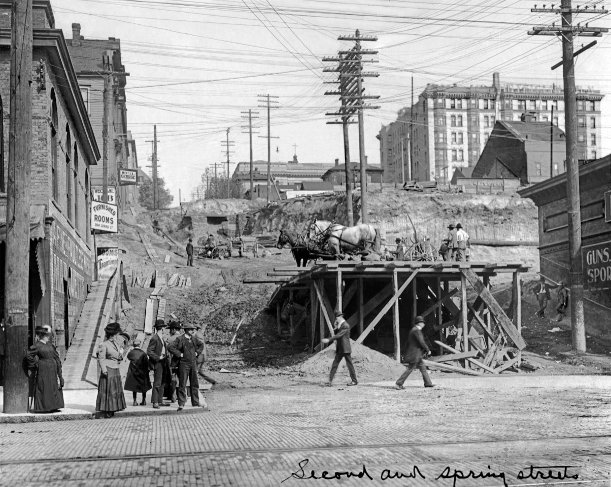
THEN: The 1906-7 regrades on Seattle’s Second and Third Avenues required grade changes on the streets that crossed them as well. Here Spring Street is being lowered to fit the new grades at its intersections with the avenues. (Courtesy: Museum of History and Industry)NOW: The northwest corner of the Seattle Public Library’s post-modern block is partially hidden here behind the One-Way sign at the intersection of Second Avenue and Spring Street.
Penned across the bottom-right corner of this week’s featured photo, is its location: Second and Spring Streets. The caption is easily confirmed by both landmarks and signs. For instance, the street name, ”Second,” is nailed to the power pole on the left. This view looks east up Spring Street from Second Avenue. (We have also posted below Jean’s “now” the flip-side of the featured subject,) which is kept in the Museum of History and Industry’s collection of historical photographs.)
Spring Street regrade looking west from the alley between Third and Fourth Avenues. (Courtesy, Lawton Gowey)Looking north on Third Avenue from Spring Street, following the regrade of both Third Avenue and the front hump or summit of Denny Hill. It cannot be found here. Circa 1909.Lawton Gowey’s look south on Second Avenue and over its intersection with Spring Street, on April 16, 1967, and so not quite the “summer of love.”
Most historical photographs taken in the central business district record the relatively long avenues that run north and south along the western slope of First Hill. The streets climbing the hill are wonderfully revealed from Elliott Bay but not up close. With Seattle streets, pioneer photographers gave some interest to Mill Street (Yesler Way), Madison Street, and Pike Street. The others were given less regard.
Detail from the 1912 Baist Real Estate map with Seneca on the top, Madison at the bottom and Spring between them. The detail extends west to east from Second Avenue on the left to Sixth Avenue on the right. You will find here the Seattle Public Library, Providence Hospital, Lincoln Hotel, the Elks Club Bldg, and upper-left all the structures facing Spring Street – most of them brick (red) – between Second and Third Avenues.The Lincoln Hotel as seen looking northwest over the intersection of Fourth Avenue and Madison Street. The latter is bordered (still) by its poplars. (Courtesy, MOHAI)
The featured photograph’s look up and through the regrade upheaval on Spring Street includes small parts of structures that in their time were proudly considered landmarks. Also unsparingly revealed here, upper-right, is one big landmark: the Lincoln Hotel, Covered with white bricks and stone, it stood for twenty years at the northwest corner of Fourth Avenue and Madison Street. Opened in 1900, its inaugural name, the Knickenbacher, was later dropped for
reasons not explained in the boasting advertisements and press releases that described it as “Seattle’s first apartment hotel.” For the generally upscale tenants it came with a lavish pleasure garden on the roof. For its last tenants the Lincoln left with tragedy: a sudden fire that killed four including a father and daughter who jumped together from their sixth floor apartment to the alley.
The west facade of the Lincoln Hotel ruins with the Elks Club on the left and the Carnegie Library’s south side facing Madison Street beyond the right side of the ruins.
We will use the hotel to find parts to three more landmarks. First Seattle’s central library, the largest of the Seattle libraries built with a Andrew Carnegie endowment. We can find most of its roofline, but not much else, to the left of the Lincoln. Like today’s library it faces west from the east side of Fourth Avenue, between Madison and Spring Street. The Carnegie library was dedicated on December 19, 1906, where that public guardian of the vox populi still stands two plants later. Its northwest corner shines near the center of Jean’s repeat.
The Carnegie Library during its late construction and so without the elaborate stairway that came with the Fourth Avenue Regrades. The view looks east from the southwest corner of Fourth Avenue and Spring Street. (Courtesy, Seattle Public Library)The Seattle Public Library fronting Fourth Avenue with its grand stairway.
After a half-century of wear the beau-arts structure was razed in the last 1950s for a modern one of mostly glass.Providence Hospital on the east side of Fifthi Avenue as seen from (apparently from the roof or upper window of the new library. Madison Street, lined with its poplars, is on the far right.
The cross rising here (in the featured photo) seemingly from the roof of the library, topped Providence Hospital, another pioneer landmark. The construction began in 1882 on the east side of Fifth Avenue. Fifty-seven years later the site was fitted with the surviving Federal Court House.
The Federal Court-house on the east side of Fifth Avenue, between Spring and Madison Streets.
With some help from the what remains of the Third Avenue Theatre at the northeast corner of Third Avenue and Madison Street, we have pulled circa dates of late 1906 or early 1907 for the featured photograph. The barn-like rear of the theatre partially hides the west façade of the Lincoln Hotel. The regrade’s deep cuts at Third and Madison left the theatre’s front door stranded high above the new grade. Russel and Drew, the theatre’s managers explained in a caption to another photo of the threatened theatre that “The work (of razing the theatre) will be started at once, and in a few days a vacant lot will greet the eye where once stood one of the most popular and successful playhouses in all the West.”
THE THIRD AVENUE THEATER looking northeast thru the intersection of Third Avenue (on the left) and Madison Street, with the Lincoln HIotel still standing upper-right.First published in The Times on December 12, 2004.
WEB EXTRAS
Anything to add, goslings?
=====
First appeared in The Times long ago – on December 12, 1984 with Ronald Regan in the high chair and the promise of an Orwellian Christmas for all faiths. (CLICK TO ENLARGE)
THEN: A stately side of Georgetown’s business district, ca. 1920. (Museum of History and Industry)NOW: Only the brick Hamilton Building survives, centered on the west side of 12th Avenue South between S. Vale (on the right) and S. Harney Streets
This week PacificNW readers are asked to figure on their own the date of this Georgetown street scene, perhaps from the motorcars that are parked on it. Whatever the year, and I’m speculating ca. 1920, the spread of businesses in the three contiguous business blocks snugly grouped here on the west side of 12th Avenue South, south of Vale Street (on the far right) is downright inviting.
We have (as yet) not a date search for this Frasch real photo postcard, but he was very active between (about) 1907 and 1914. Somewhere on the Web a descendant has followed his career. Perhaps you can find it. (For me, it is now 4am.)
Starting at the sidewalk on the left, at the corner with S. Harney Street, are “Roma Imported,” mostly hiding behind the open delivery van, and a market of fresh produce sharing the first floor of the smallest of the three two-story buildings grouped here. One can imagine vegetables in the boxes shining through the plate glass window. Most likely there are a few rented apartments upstairs.
Here on Jan 3, 1926 Georgetown got its coverage from The Times series on local neighborhood in the 1920s. CLICK TO ENLARGE
The bigger building at the center is “The Hamilton.” It is prominently and appropriately signed in relief with more bricks carefully set on its all-brick façade. We have learned from John Bennett, one of Georgetown’s contemporary freeholders, that it is actually a concrete box covered on the street side with a layer of decorative brick. More than a century of rains have seeped between the box and its covering, staining some of the latter. The construction date, 1907, has been artfully split to either side of the hotel’s name.
A Times clip from July 12, 1908. (click to enlarge)
The structure’s three sidewalk shops are, left-to-right, first a shoe repair, neighbor next to the Working Man’s Store, which features both clothes and shoes. (Perhaps one could purchase both new and used shoes here, although we will note that this glass negative was recorded by the Webster and Stevens Photography Studio years before the Great Depression when used shoes were in greater demand.) The third of the merchants busy at the sidewalk is the White Front Restaurant. It is neatly signed on the window.
The Seattle Times for January 3, 1908, reports that “The Georgetown post office and the Georgetown pharmacy have been moved into new quarters in The Hamilton Building, a brick structure.” These are nearly the building’s first tenants for the Hamilton was then barely a year old. Also in 1908, The Hamilton welcomed as a tenant John Mueller, the manager of Georgetown’s new and huge Rainier Brewery. Mueller opened an office in The Hamilton for his mayoral campaign, which he easily won. The Times explained that George Brown, his opponent, “is not making an active fight.”
Marcus and Martha Hamilton and their family lived behind their namesake hotel and hall. They owned the block. Marcus served many mostly uncontroversial years as a King County Commissioner. When the first five floors of the City-County Building at 4th and Jefferson were dedicated on May 4, 1916, Marcus was the keynote speaker along with Hi Gill, Seattle’s exceedingly controversial mayor.
With its big room and high ceiling on the second floor, Hamilton Hall served a wealth of patrons for campaign rallies, dances, secret society meetings and such and such. Its rooftop sign radiates like the sunrises it faced over Beacon Hill between 1903, the year of its construction, and 1972, the year of its tear-down.
WEB EXTRAS
Anything to add, lads? Sure Jean, sometimes we aim to please. Other times we need to sneeze. It is one still step after another. Keep on trucking. Tragedy/Comedy. Here’s more from the neighborhood widely conceived
=====
=====
=====
=====
Tim O’Brian, Georgetown historian, on his stairway.
THEN: At the Federal Courthouse on February 17, 1970. By and Courtesy of Doyal Gudgel Sr. and Jr.THEN: Still at the Courthouse, on April 17, 1970. By and Courtesy of Gudgel Sr. and Jr.NOW: Some combination of Jean’s quick wit and good fortune allow us to repeat the ecstatic protester with his arms raised with a pigeon preparing to either land or take off from the Courthouse’s top step. Jean’s and my friend, the author Clay Eals, reminds us that “The pigeon is the dove of the street.”A few Freeway protest shapshots by Doyal Gudgel Sr. mixed in with Federal Courthouse scenex, also by Gudgel, looking east across 5th Avenue from the rear of the Seattle Public Library. CLICK TO ENLARGEA Times clipping from April 18, 1970.
I first read Kit Bakke’s ‘Protest on Trial’ as a work-in-progress. The book’s publisher, Washington State University Press, shared a copy of the manuscript with me for comment, and as I read through it I increasingly responded with recommendations. This week’s edited excerpt of the book’s brilliant late chapter on courtroom mayhem should, I hope, inspire many PacificNW readers to read it all.
Doyal Gudgel Sr. snapped the two “more” historical photographs printed here in 1970 at the front door of the Federal Court House, directly across Fifth Avenue from the Seattle Public Library. The oldest one, with the phalanx of helmeted Seattle police guarding the courthouse’s broken front door, was photographed on Feb. 17, 1970. That was TDA or “The Day After”, a one Winter day of protest. (Again, I’m confident that readers will be enlivened to learn more about the TDA and the many political shenanigans surrounding it by reading the book.) Besides smashing the front door, angrier TDA protesters also threw paint, and some of it can be seen in long drippings above the front door.
The caption for this Times clipping of April 18, 1970 reads, “S.L.F. in COURTHOUSE PROTEST, Members of the Seattle Liberation Front gathered on the steps of the United States Courthouse yesterday to denounce the Justice Department for wht they called an attempt ‘to crush our organization.’ The accusation was made after eight S.L.F. leaders were indicted by a federal grand jury for inciting violence in a demonstration at the courthouse February 17. – Times staff photo by Pete Liddell.”
It seems (at least) that in the second Gudgel snapshot (at the top) the running paint survives as a smear above the same door on April 17, 1970 when it was time for another organized protest. (Read the book, OK?) As a “stringer” providing both still shots like these and 16mm film for media clients and law enforcement investigations, Gudgel responded to opportunities he first discovered on the police radio reports he listened to while tending his store, Burien Radio and Television.
A 5th Avenue sit-in related to the TDA of 1970. The Federal Courthouse it off-camera to the right and the public library to the left, both out-of-frame.
The photographer most likely arrived somewhat late for the April recording at the Courthouse. The day started with a protest march in morning rain, while here the afternoon sun casts long afternoon shadows. To these eyes Gudgel’s April recording resembles a designed tableau. The man on the far left seems to be drawn, at least in profile, from a central casting for tough investigators.
A comparison with the righ half a detail clipped from the second photo from the top and the left half also showing Seattle Seven member Jeff Down on the far left. That the two Doyal Gudgel photos were shot on the same day can be figured from some of the clothes shared between them.
The sunlit April photograph is aiming at one of the Seattle Seven: Jeffrey Alan Dowd, who at 20-years-old carried a mop of curly hair above a still cherubic face. Now decades later Dowd, living in Southern California, is better known as “The Dude” an eccentric pop creation from Hollywood. Here the pre-dude Dowd is cradled by admirers of his political courage, some of them showing fists and one of them slim arms reaching, it seems, in reverence.
WEB EXTRAS
Anything to add, troublemakers? Yes Jean we will stir a few more column inches below with more features.