THEN: The 1937/8 tax assessor’s photo of 4013 Maryland Place, precariously built on the east slope of West Seattle’s Duwamish Head. (Courtesy Stan Unger)NOW: Jean Sherrard’s “repeat” uses a wider angle in order to also reveal the landmark stone house facing Harbor Avenue. The footprint of the red home in the background is near the featured frame residence on Maryland Place.
Although certainly not obvious, the setting of the slender two-story home standing at the base of West Seattle’s Duwamish Head in our “then” is repeated in Jean Sherrard’s “now.” It is the red and gray modern residence held in a verdant caress just this side (to the east) of California Boulevard S.W. The home and the trees hide the Boulevard, which is the long arterial connection between the top of Duwamish Head and the shoreline parks and mostly condominiums, respectively, to the east and west sides of Harbor Avenue.
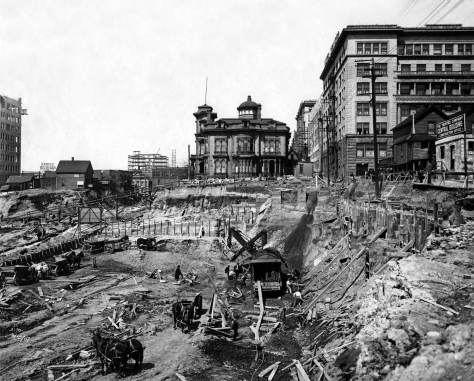
The Duwamish Head neighborhood in a detail from the 1908 Bsist map. Maryland Place appears on the right between Ferry (California Blvd. S.W. ) and Railroad (Harbor) Avenues.At some point on the left (east) side of this look south down California Blvd S.W., Mayland approaches but does not reach it as the 1908 Baist map, above, has it. This and the photo below it show work-in-progress on improving the former cable car route for motorcars and trucks.Looking back and north from Harbor Avenue to the early work-in-progress on improving the arterial qualities of California Blvd. S.W.Another Baist detail, four years later in 1912.
With Clay Eals, one of the most confident modern boosters of West Seattle, at his side, Jean Sherrard aimed his Nikon southwest across Harbor Avenue to one of the Head’s best known and most sentimental landmarks, Eva’s Stone Cottage. The framing of the beachside home with a marine view of Seattle was finished in the late 1920s. Asked by a granddaughter how she would like the house finished, Eva answered, “Well, what about putting little rocks from the beach on it?” With her family’s help, this prolific collecting we suspect continued into the Great Depression. Now Eva’s Stone Cottage is one of the few beachside homes surviving in the increasing crush of modern condominiums.
An only a few years earlier recording of the stone home on Harbor Avenue.
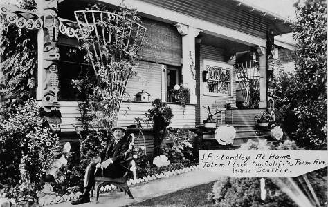
After crossing Harbor Avenue, Jean and Clay continued around the corner of Eva’s home and climbed the length of what must be one of Seattle’s shortest streets, the half-block-long Maryland Place. In order to save room for Eva’s Stone Cottage at the corner, we have not included Jean’s more precisely recorded repeat of our feature at 4013 Maryland Place S.W. When completed at the cusp of the Great Depression, the cottage was topped with a waving cornice made from the darker rocks that the family carried home in their wheelbarrow.
CLICK TO ENLARGE
There are a few implied ‘stories’ about the featured house found in public records. First, from its 1938 tax card, the date for construction, 1920, is years late. In a Seattle Streets Department photo that is convincingly dated November 1916, the home is shown standing. The tax photo attached to the card used here was recorded in 1937-38 during the Works Progress Administration’s photographic inventory of every taxable structure in King County. The assessed value for these two lots were thirty dollars for the land and $230 for the home. Two years later the home was visited by tragedy when resident nineteen-year-old John R. Lofstad was listed in The Times “Vital Statistics” feature as having died from an automobile accident.
A public works photographer looks down (east) on Maryland Lane from California Blvd. S.W.. The featured home survives having withstood a winter storm recorded here on February 11, 1916. The message attached at the top is part of a communication between Jean and I. CLICK T O ENLARGE.
WEB EXTRAS
This photo is a more precise repeat of the ‘Then’ shot above. Strolling down the walk are (from left) Clay Eals and John Siscoe
Anything to add, kids? Yes Jean. Ron and I send along more features from the neighborhood – widely cast.
=====
GOOD VIEW LOTS
=====
=====
=====
CA. 18[90 sketch of Alki Point from Sunset bluff.=====
In 2018 six beehives were installed at the foot of the Louvre in the Raffet garden. It is such a vision, almost an impressionnist joy to contemplate so many beauties without pesticides in a field much more larger than a painting …
En 2018 six rûches ont été installées au pied de la façade du Louvre dans le jardin Raffet. C’est une telle vision, presque une joie impressionniste de contempler toutes ces beautés sans pesticides dans un espace beaucoup plus grand qu’un tableau…
THEN: Members of the Love Israel Family performing beside the Flag Plaza Pavilion (note the sign upper-left) at the Folklife Festival on May 30, 1976. (photo by Frank Shaw)NOW: Members of the Mad Robins posing for Jean Sherrard in front of Seattle Center’s Fisher Pavilion, which replaced the Flag Pavilion in 2002. From left: Michael Karcher (caller), Brandon Ananias Martin-Anderson, Amy Hanson Wimmer, Diana Herbst, Isaac Sarek Banner, Abigail Hobart, Anita Anderson, Melissa Coffey, David Kessler
Both groups posing her performed at Seattle’s by now venerable Northwest Folklife festival. The earlier pleased posers are all members of the Love Israel religious community, living then near each other in several homes on Queen Anne hill. They are performing from the Seattle Center stairway, between the Flag Plaza Pavilion built for Century 21 (our World’s Fair of 1962) and the Folklife visitors seated on the plaza behind photographer Frank Shaw. (You cannot see them.) Shaw was a skilled amateur who filled several binders with his 2×2 negatives and transparencies (slides) recorded on his camera, a Hasselblad I envied then and still do.
Another Shaw photograph, this of the family’s booth at the same 1976 Folklife Festival at Seattle Center.
Posing for Jean, the contemporary players have named themselves the Mad Robins, and dress appropriately. Earlier singing a cappella (without instruments), they accompanied contra dancers at this year’s Folklife Festival. By Jean’s accounting they sang very well. To prove it, Jean both recorded their performance and edited it into a youtube video that you will also find with a link below under WEB EXTRAS.. The Mad Robins’ own description of themselves is packed with joyful influences. ”We are a group of eight contra dancers who also sing in a variety of traditions: sea shanties, barbershop quartet, Sacred Harp, pub carols from the British Isles, folk songs, Broadway show tunes, and choruses.”
Later than Love Israel, a quartet of “old music” players perform on Seattle Center steps that seem to be under repair. I, Dorpat, took this about 30 years ago. Perhaps someone will write us with all the names and we will insert them for old time posterity.
Thanks to Red Robin Melissa Coffey for help with the Red Robins and to both Rachel Israel and Charles LeWarne for their help with Love Israel history. Historian LaWarne’s book, published by the University of Washington Press and sensibly named “The Love Israel Family,” is in print.
An early Folklife scene by Frank Shaw, which he carefully dated on the slide’s holder, May 28, 1973,Probably the only one-man band at the 1986 Folklife Festival.Folklife 1986, lead member of the popular band then, the Dynamic Logs, takes an opportunity to rest his guitar between acts.Seattle Folk legend, Stan James, at Folklife in 2003, or possibly 2004, as a member of the Halibuts, a trio; of friends who performed songs written by local Clam King, Ivar Haglund.Tired dogs at the unseasonably warm 2009 Folklife. These dogs were also employed to sell a chow that was purely for pets and by some generous appreciation of our best friend was promoted at the folk festival.A portion of the landscaping at the east end of the Flag Plaza Pavilion in the 1970s photographed by Fred Bauer.Hucksters/Hustlers at the 2012 Folklife Festival. I gave them five dollars with the promise that they would heal their pipe for as I explained I doubted that they could get a new one out of my philanthropy. .
WEB EXTRAS
Jean here. I’ve added a photo of The Mad Robins in performance at this year’s Folklife:
And here’s a short video of their performance provided by member Melissa Coffey:
Anything to add, compañeros? First, congratulations to Jean on completing the staging and directing what I’ll estimate was your 75th play with the good student-thespians of Hillside Academy. Will you please estimate the number of productions that comprise your total Hillside opera, so far? Hillside is featured with a link at the top of the blog’s front page, in the column directly to the right.)
Here follows a small spray of weekly links pulled from the last 37 years. CLICK to open and CLICK to enlarge.
========
=====
=====
=====
=====
=====
=====
=====
=====
=====
=====
=====
=====
=====
=====
BELOW: A REMINDER TO VOTE THIS NOVEMBER
FRANK SHAW, the photographer lived next door to Seattle Center. He recorded this photograph of circus elephants on July 22, 1965 . We use it here as a reminder to vote this November.
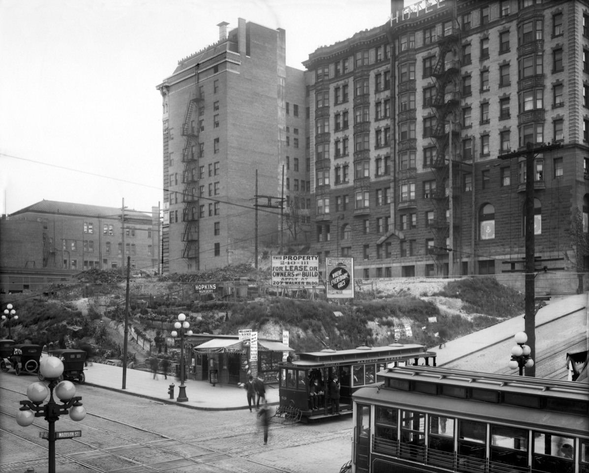
THEN: Sighting northwest through the intersection of Madison Street and Third Avenue, circa 1916. (Courtesy, Museum of History and Industry)NOW: SeaFirst Bank began buying up the block in the late 1950s and opened its fifty-floor tower in 1968.
May we note first a happy coincidence –instructive too – between this week’s “then” and “now?” Jean Sherrard has lifted his Nikon to a prospect above the southwest corner of Third Avenue and Madison Street that seems to resemble the elevation reached about a century ago by the more historical, although unnamed, photographer. Jean has extended his pole-mounted camera into a zone of overhead wires that may resemble – for you too? – that surreal moment when the spacecraft Cassini passed through the Rings of Saturn.
The Third Avenue Theatre at the northeast corner of Madison Street and Third Avenue.
In fact, Jean’s camera has paused here for his “click” within a few inches of where the sidewalk sat 110 years ago. That was before the Third Avenue regrade cut seventeen feet from the intersection. Before the cutting, cable cars on Madison Street climbed the third steepest grade in the cable car industry here between Second and Third Avenues.
The rough half-block displayed in the feature photo at the top, survives in this 1913 detail from a photo taken from the Smith Tower in the last months of its construction. Enlarge this illustration and you will better find the signs holding to the half-block in the “Then.” The Lincoln Hotel is there as well, but not the Elks Lodge. Years later (less than six) the half block facing Third Avenue’s east side between Madison and Spring Streets is being fitted for “Real Estate Row”, the one-story brick addition that ran the length of the block.An advertisement generated from “Real Estate Row” on Sept. 1, 1920. It appeared the The Times, which we can now sample from its digital archives shared by The Seattle Public Library. If your have a SPL card you will enjoy exploring with it, this we promise. If not get a card and call the library for instructions on how to link to it.
The intersection’s rough northeast kitty-korner still shows the scars left by the deep grading along both Third and Madison about ten years before the “then” was recorded ca. 1916. From 1890 until its destruction in 1906 by regrades, this northeast corner was the home of “polite vaudeville,” with a “family formula” featuring acts “without booze, peanuts or catcalls.” Here the scarred corner has been terraced for and signed by the Hopkins Nursery, perhaps the British-born Thomas Hopkins who with his sons later ran an award-winning and long-lived nursery in Bothell. To this side of the terraced nursery, sits a nifty two door shed at the corner. It promotes itself as a “union shop” that from toe to top cleans, shines, and dyes “ladies and gents shoes,” and also sells, cleans, presses and reblocks men’s hats.
CLICK TO ENLARGE
The largest sign stuck in the dirt above the corner shed reads, in part, “For Lease or Owners Will Build.” Soon the east side of Third Avenue between Madison and Spring Streets was fitted with an array of single story brick storefronts, and was popularly called “Real Estate Row.” All the sidewalk shops were fitted with skylights of the same sort and size – at least ten of them. Behind the retail “row” was another of cars, parked west of an alley running the block. East of the alley and up the hill were the two landmark buildings filling much of the frame. On the right is the Lincoln Hotel built in 1899 and destroyed by fire in 1920. Left-of-center stands the Elks Club, dedicated in 1914 and sold to Jewish Group in 1958 that sold it to the bank in 1964 for the building of their dark glass-curtain tower, dedicated in 1968. (Greg Dziekonski, a helpful fact-checking reader, tells us that “The Seattle Youth Symphony rehearsed in this building from 1958 to 1961 when it was the Jewish Community Center.”)
The SeaFirst Tower was completed in 1968.Lawton Gowey’s record of the nearly new SeaFirst Tower photographed from the Smith Tower in 1971.
Far left in the featured photo – printed at the top – and facing Fourth Avenue a half-block north, the Independent Telephone Co. completed the photo’s frame on the left. It joined the hot early twentieth century competition to wire, mostly from competing poles, the city with telephone lines. Erected in 1902, the building’s “most interesting part,” the Times reported, was its concrete floors and partitions. It was “a feature never before employed in the construction of any other building in Seattle.”
A Times clip from August 24, 1902 revealing the redundant rush and opportunism of competing telephone companies early in the 20th Century..
WEB EXTRAS
Anything to add, mes braves? Surely. Ron may add some to what below when he arises from his late Spring-Sunday-Morning Sleep.
Meanwhile . . .
:Looking east from the roof of the hotel. The towers on the right belong to Central School facing ‘Marion and Madison streets between Sixth and Seventh Avenues, and behind those the two towers of Saint James Cathedral can be glimpsed at the southeast corner of 9th Avenue and Marion Street.
Looking northwest over the intersection of Fourth Avenue and Monroe Street, and the poplars that once bordered the latter.CLICK TO ENLARGE: Lincoln Hotel before the poplars on Madison. The Seattle Public Library is on the right, and the harbor is exceptionally busy with the illustrator’s fleet. (Courtesy, Michael Maslan)On of the many parades produced for the 1911 (or possible ’12) Potlatch Parade passed through the intersection of Fourth Avenue and Spring Street. Together the Lincoln, on the left, and the Elks Lodge, on the right, press against their neighbor, a frame house larege enough to hold lodgers.
=====
======
=====
=====
=====
=====
=====
=====
=====
=====
=====
LINCOLN’S FATE BY FIRE
Larry Hamilton gave me a witness’s account of the 1920 fire that destroyed the Lincoln Hotel. Larry and I became friends through our common interest in local history and more, our study of it as well. Larry did the darkroom work for the Museum of History and Industry, although by the time I met him he had moved on from that charitable work to others, like accompanying me to lectures and shows and such. I drove. This photo of the ruins comes from Larry and it was accompanied with his story of the fire. If memory serves he arrived in Seattle on the day of the fire or the day before it. Whatever he could give it a sensational refiring. We kept it up – our explorations and friendship – until his death in his 90’s. Would that you (dear reader) and I could bank that vitality. Perhaps his greatest virtue was his sense of humor. He was good a promotion for life everlasting. Hamilton would never run from or out of wit. See you later Hamilton. Just kidding Larry. “Nor can joy be long sustained.” George Santayana. (1863 – 1952). From this southeast prospect here is surely a building in trouble. It requires an inspection from the west to dampen – with the fire fighters’ shower – any thought of restoring the Lincoln.Looking down we find some of the Real Estate Row facing the sidewalk on the east side of Third Avenue.
THEN: Built in 1869 by Seattle pioneer Carson Boren at the southeast corner of Third Avenue and Union Street, the charming structure was home for Carson’s mother Sarah Denny and her second husband John Denny, the father of Seattle founders Arthur and David Denny. (Courtesy, Museum of History and Industry)NOW: The city’s main branch of the federal post office was built on the corner in the first years of the 20th Century. Its sandstone beaux-arts architecture was replaced in the late 1950s by a modern glass curtain.
On the flipside of the scuffed original print, the caption reads “Built in 1869 by Carson D. Boren for his mother Sarah Latimer Boren Denny – it is now the present site of main post office at Third and Union.” Actually this tidy home was built for both Sarah and her husband John Denny, the father of Seattle founders, Arthur and David Denny. She was John’s second Sarah, who, in 1851, with her grown son Carson, joined David and his sons for the seven-month trek on the Oregon Trail to the Willamette Valley. (John’s first Sarah, his wife for 27 years, died in 1841 at the age of 44.)
The early work of construction on the city’s grand P.O. at the southeast corner of Third Avenue and Union Street was confounded by the city’s decision to regrade Third Avenue the distance from James Street to Pine Street where Third was interrupted by Denny Hill. The lowering of Third Avenue resulted in the addition of new ground floors (and basements) for many of the businesses and homes facing Third Ave. Here at Union the new P.O.’s planned front doors facing Third were accommodated with steps that reached well into the sidewalk. This extension can be found above the trolley approaching Union Street in the bottom-right corner of in this photograph. Similarly, at the corner, new steps are spread across the sidewalk. Both proved popular, and became oft-used places for arranged meetings among workers and shoppers. “I’ll be waiting at the Steps.”
The Dennys had been a successful farming family of exceptional industry, building successful farms in both Indiana and Illinois before together catching the “Oregon Itch” for the warmer and more lugubrious winters promised in the Willamette Valley. There they built a third farm, while their grown children continued on to Puget Sound’s Elliott Bay to found a town they named after the helpful Duwamish headman, Seattle. In 1858 the parents joined their pioneering children in Washington Territory.
While still in Illinois John Denny had served in the state’s legislature with his friend Abraham Lincoln. Both were admired – and elected – as Whig wits with the gift for telling good stories. Gordon Newell, one of Washington State’s author-solons, described John Denny as an “American pioneer and frontiersman, citizen soldier and homespun politician.” As John’s sense of humor provoked mirth he was often chosen as speaker, or master of ceremonies for community events such as a Fourth of July celebration. In 1868, as a member of the fledgling Seattle Library Association, Denny gave what pioneer historian Thomas Prosch described as a “series of lectures on the progress of science and art,” which Prosch attended.
In her still enjoyed book “Pig-tail Days in Old Seattle,” Sophie Frye Bass remembers her great-great-grandmother Sarah and the atmosphere of her home. (John had died in 1875, the year that Sophie started primary school.) She writes, “Great Gramma’s place was a little white gabled house with wide porches. It had tiny panes of glass on either side of the front paneled door and a funny bell which I loved to ring. I recall the hit-or-miss rag carpet, the marble-topped table with the knitted cover that held the family album and stereoscope. If I were a good girl, I was allowed to peek through the stereoscope, which seldom happened. … On the dresser in the tiny bedroom were bottles of hartshorn and camphor. The little house had the sweetest odor – indescribable – an odor of spices and old mahogany furniture and a whiff of some delicious cake backing in the oven.”
A detail pulled from the panorama below it by G. Moore in the early 1870s. Here the Territorial University stands top-center on Denny’s Knoll with a still forested First Hill horizon behind it. The clear-cutting was on its way. The John and Sarah Denny Home is at the southeast corner of Third Ave. and Union Street, directly below the school on its knoll. A portion of the coal railroad’s narrow-gauge track runs along Pike Street just beyond the undeveloped lots above the fence at the bottom. In the 1870s the coal was carried by rail from the south endof Lake Union to bunkers at the end of the Pike Street Wharf. The operation was moved in 1878 to the new coal wharf and bunkers off of King Street.. These CANNOT be seen in the panorama below, nor can the tracks that would be extended across the tideflats from the King Street Wharf to Renton and Newcastle for more coal. G. Moore’s pan looking south from the southern slop of the southern summit of Denny Hill. (Courtesy, MUSEUM of HISTORY and INDUSTRY) CORRECTION: Would like to change the last sentence of the feature above from March 5, 1995 to read “two or three years before this view was recorded.” We continue to learn – and make mistakes.
”Before the southeast corner of Third Avenue and Union Streets was chosen by the feds for Seattle’s new and grand beau arts P.O., the corner was home to the Plummer Block. (We have written about this with a feature but cannot for the moment find the clipping to scan – for you.
WEB EXTRAS
Just for beauty’s sake, I’ll toss in an early morning shot of Rainier, taken from the 80th St. overpass over I-5 last week:
Anything to add, ducks? Jean, proud are Ron and I with our quackery are inserting more features from the neighborhood. However, and frankly, we wonder if in choosing to insert this “The Mountain That Was God” testimony, had you taken note of what we think is an eagle soaring there and not a duck. While we do not blame you, we wonder if you could have been more careful.
=========
=========
Looking south on Third and thru Union Street to work-in-progress on the city’s new Post-Office. The tower of Plymouth Congregational Church stands at the end of the block facing University Street. Ca. 1904Showing beneath the slightly older photo printed above are the new front steps of the new P.O. facing the lowered grade on the new Third Avenue. And take note, perhaps, of the people meeting on the steps.
=====
=====
=====
=====
=====
Like the two “shots” that follow, this was recorded in the mid-1980s. The glass-curtain modern facade from the 1950s has since been remodeled for other tastes.
=====
=====
=====
A pioneer Seattle baby photographed by the same Moore who recorded the panorama near the top.
THEN: The Leland Hotel survives – although with many changes – as a market corner stone where Pike Place begins at the foot of Pike Street. One of the earliest adjustments cut away its east façade with and for the 1906-7 development – at an angle – of Pike Place. . (Courtesy, University of Washington Library’s Northwest Collection.)NOW: In a “tug-of-peace” between repeating the “then” outside with some of the Pike Place pavement, Jean Sherrard, after attending a meeting in HistoryLink’s newest home inside the Market, wisely chose this interior recording, which includes a mother and son, we assume, reaching for Rachel, the Market’s mascot and its bronze piggy bank. The five posers at the center are, left to right, Marie McCaffrey, a HistoryLink founder, publisher Petyr Beck, and HistoryLink staff members David Koch, Jennifer Ott and Antonia Kelleher.Here’s a coupling of the featured photo with a detail from the 1904 real estate and fire map published by Sanborn, The Leland is foot-printed in the map, although not named. (Click and blow it UP now) . The Leland is titled or named simply “Lodgings” and on the map as in life it is at the foot of Pike Street, bottom-left. The front door is there, a little off-center, as it is in the photograph. Post Alley is in both and well before the east facade or wall of the hotel was moved in order to make way for the making of Pike Place in 1906-7. Note the shacks and sheds north of the hotel on the edge of the of the bluff. First Avenue is on the right bordering the row of clapboards standing there. Finally, note the stairway leading to the waterfront, bottom-left. It was not the first PIke Street Hill Climb, but nearly. The first was the narrow-gauged railroad viaduct on which the coal gondolas were lowered to the Pike Street Pier or wharf that led to the bunkers. From 1871 to 1878 this was Seattle’s primary arterial of wealth: coal from the east side of Lake Washington carried to coal colliers from California. Our coal was, it seems, better than theirs. From the back porch or window of their studio at the foot of Cherry Street, Peterson and Bros, pioneer photographers, looked north up the waterfront to the distant Pike Street Coal Wharf in 1876. The steep viaduct that slowly let the coal cars down from the narrow-gauge railroad tracks on Pike to the Pike wharf can be seen in the forest climbing the Pike Street hill-climb on the far right.The Main Market Building, ca.1915, extended north of the Leland along the bluff and above Western Avenue on the increasingly narrowing wedge-shaped block north of Pike Street, between Western and Pike Place. Please note the temporary boardwalk built around the southwest corner of the Leland. On its way to Wester Avenue, it switchbacks around the construction sheds showing near the center of the photo. This was an early short-lived variation on the Pike Street Hill-climb.
Of the roughly 150 thousand citizens living in Seattle in 1907, nine answered to Olds – their last name – and six of these lived in the Hotel Leland. And surely all of them knew by heart the 1904 pop hit “In my Merry Oldsmobile“. (My dad taught it to me in the 1940s. He drove one.)
Here, in the featured photo at the top, stands the Hotel Leland at the northwest corner of Pike Street and the Post Alley, circa 1904. There was then, as yet, neither a Pike Place nor a Public Market, nor any intimation of either. The alley-wide arterial on the right is not a Place but an alley, Post Alley. The building of Pike Place, between this intersection and the foot of Virginia Street at Western Avenue, came suddenly, as did the founding of its namesake public market.
A rare early look west on Pike from First Avenue into the building of Pike Place. The Post Alley descends on the left, and the Hotel Leland stands upper right with its remodel including a bay window over the hotel’s front door, still on the south wall. The hotel’s bay window can also be seen in the photograph above this one, which also shows the added two floors – at the base – which came with the blocks’ new grade between Pike Place and Western Avenue.
Pike Place was cut thru in 1906-7 on the incentive of activist engineers and not by budget-conscious homemakers conspiring with truck-gardeners to exchange cash for produce in a public place like Pike Place. ( With the coming of the Market the farmers could get around the wholesale grocers’ gouging on Western Avenue.) It was the transportation planners at city hall who successfully connived to cut through the neighborhood. In this public work of creating the eccentric Pike Place, they completed City Engineer Reginald Thomson’s Route No. 15, an arterial from northwest Seattle directed into the city’s new retail center to the sides of Pike Street.
A detail from the 1908 Baist real estate map includes the Leland Hotel at its new sharpened corner at Pike and Pike Place. Note the stairway to Market Street. As described above it was for a brief period replaced with a switchback sidewalk-ramp built around the south west corner of the hotel. In 1908. Here there is, of course, as yet no sign of the Market. Rather this is the Pike Place designed for drivers and not farmers parking their wagons packed with produce. (Keep Clicking to Enlarge these Illustrations.)In the Goodwin Real Estate Co. adver from May 7, 1907 there is no hint of Pike Place’s fated Market, but rather a recognition that “Pike Place will be the main channel through which the North Seattle water front travel will pass.”
Perhaps we would be right to imagine that the suited man with the watch chain standing above, and perhaps posing, at the Leland’s front door is its owner Gamaliel T. Olds. The helpful Kate Krafft, one of Seattle’s most effective activists for historic preservation, dates the construction of the Hotel Leland in 1902-3. In the Aug. 11, 1907 classifieds for The Seattle Times – a mere week before the Pike Place Market’s grand opening – the Olds hotel was offered for sale and described as a “Lodging House, eighteen rooms; good furniture, good location.”
While the Olds were building their Leland on Pike they were running another Leland on First Avenue, north of Pioneer Square. There Gertrude Myren “inspirational psychic clairvoyant” was one their tenants. The capacities she claimed are impressive. She could diagnose and cure diseases, restore lost affection, locate mines, and “tell you all from cradle to grave.” (But why must she bring up the graves!)Nervous about the effects of the planned Pike Place Market approaching opening, the “commission men” speculate among themselves and for a Times Reporter on Aug. 7, 1907, a long week before the Market’s first sales between farmers and families, that Pike Place will be busy with “more hucksters” who first purchase their produce from the commission houses, than farmers who picked them from their own gardens. In its August 18, 1907 advertisement printed in The Times, the Goodwin brothers played on the crowded success of the public market on its first day while announcing the sale of three of their properties “south of Pine Street.” On easy terms.A Clip from the Seattle Times for Sept. 4, 1907.
It was the Goodwin brothers, the market neighborhood’s first spirited developers, who purchased the hotel while keeping one of the Olds on as its manager. Surprisingly, the democratically stressful part of the Market’s popularity soon upset M. Olds. The Times for Nov. 10, 1907 reported that he had complained that the police should “do something to prevent Socialists from attempting to hold street meetings on Pike Place . . . He complains particularly about the crowds, which he says congregate in front of his hotel much to his annoyance.” Now after the Pike Place Public Market’s first 111 years of clamoring activism, M. Olds complaining comes across as partially prescient and partially pathetic.
A clip from The Times for Nov. 10, 1907.Lots of besuited bother at the Socialist State Convention in Seattle, 1914.
WEB EXTRAS
Anything to add, mates? Surely captain. More from the neighborhood.