THEN: Behind the pergola, Henry Yesler’s hallmark Pioneer Building (left, 1890) and the stately flat-iron Seattle Hotel (1891) straddle James Street. The stairway to the park’s luxurious lavatory is seen beneath the pergola at front, near First Avenue. (Webster & Stevens, Paul Dorpat collection)NOW: A 21-foot extension pole allowed for the capture of a slightly lower prospect. In the 1960s, the red Pioneer Building (behind the trees) became an icon for preservationists who spearheaded creation of the Pioneer Square Historical District in 1970. The Seattle Hotel, infamously demolished in 1961, was replaced with the “sinking ship” parking garage, now squatting below Smith Tower (1914). Reportedly, the sealed-off lavatory still exists but can be accessed only via a utility hole. (Jean Sherrard)
(Published in the Seattle Times online on Jan. 21, 2021
and in PacificNW Magazine of the print Times on Jan. 24, 2021)
Underground convenience, sheltered from the storm
By Jean Sherrard
From a rooftop vantage in 1910, our “Then” photo looks east to a newly completed cast-iron and glass pergola straddling the triangular city park of Pioneer Place, now Pioneer Square. A collision of junctions charting early settlers’ land disputes, this fertile ground set the stage for Seattle’s future.
After the Great Fire of 1889, a downtown built of brick and stone rapidly rose from the ashes. Prolific architect Elmer Fisher led the charge, designing dozens of buildings in the muscular — and fireproof — Romanesque Revival style.
Taking the lead in 1890 was Henry Yesler’s Pioneer Building, the massive edifice at left. No slouch at right, on the south side of James Street, was the Seattle Hotel, built in 1891 on the flatiron footprint of its destroyed predecessor, the Occidental.
Soon, fueled by coal and gold, adolescent Seattle nearly tripled in population to 237,194 in 1910 from 80,671 in 1900. Improvements in plumbing, electricity and transportation met the expanding need while the city also eagerly planned its coming-out party, the 1909 Alaska-Yukon-Pacific Exposition.
Boosters anticipated visitors from across the globe, many of whom would arrive by train and ship, passing through Pioneer Place, Seattle’s commercial hub. But they sensed that a key convenience was missing.
Their solution — considerate but controversial — was to build a lavishly appointed public lavatory with walls of Alaskan marble, brass fixtures and terrazzo floors. To welcome the expected hordes, the vision was to bury it at Pioneer Place and cover its stairwell entrance with a graceful, Victorian-style pergola that would double as a shelter for streetcar passengers.
A flurry of letters and editorials erupted. Many lamented potential loss of the tiny greensward. Others forecast yet another promotional feather in the city’s cap. In the end, fans of the commodious “comfort station” won the debate, and excavation began.
The dig yielded an intriguing archeological find. Newspapers breathlessly reported the unearthing of Henry Yesler’s 1852 sawmill foundations, west of the Pioneer Building where his first home once stood.
The lavatory and pergola, designed by architect Julian Everett, proved late for the dance, opening Sept. 23, 1909, mere weeks before the exposition closed. But naysayers fell silent when the underground toilets proved immensely popular, averaging more than 5,000 flushes a day.
The palatial privy survived until the late 1940s, when it was abandoned and capped off forever. The pergola, however, endured. Intermittently ravaged by rust, earthquakes and errant trucks, it has been restored repeatedly over the years and continues to serve as a reservoir of history and shelter from the storm.
WEB EXTRAS
What a treat! One of those rare occasions in which Jean uses his 21′ extension pole. Its full length must be seen to be believed. Check out our 360 video for proof.
And these just in! Our longtime column partner, photo historian Ron Edge, sends along two photos, which more precisely illustrate the entrances to the palatial loo.
Also, we present a floor plan for the underground restroom, a 1970s view of its deteriorated state, and a Seattle Times photo of the excavation prior to construction of the “sinking ship” garage nearby.
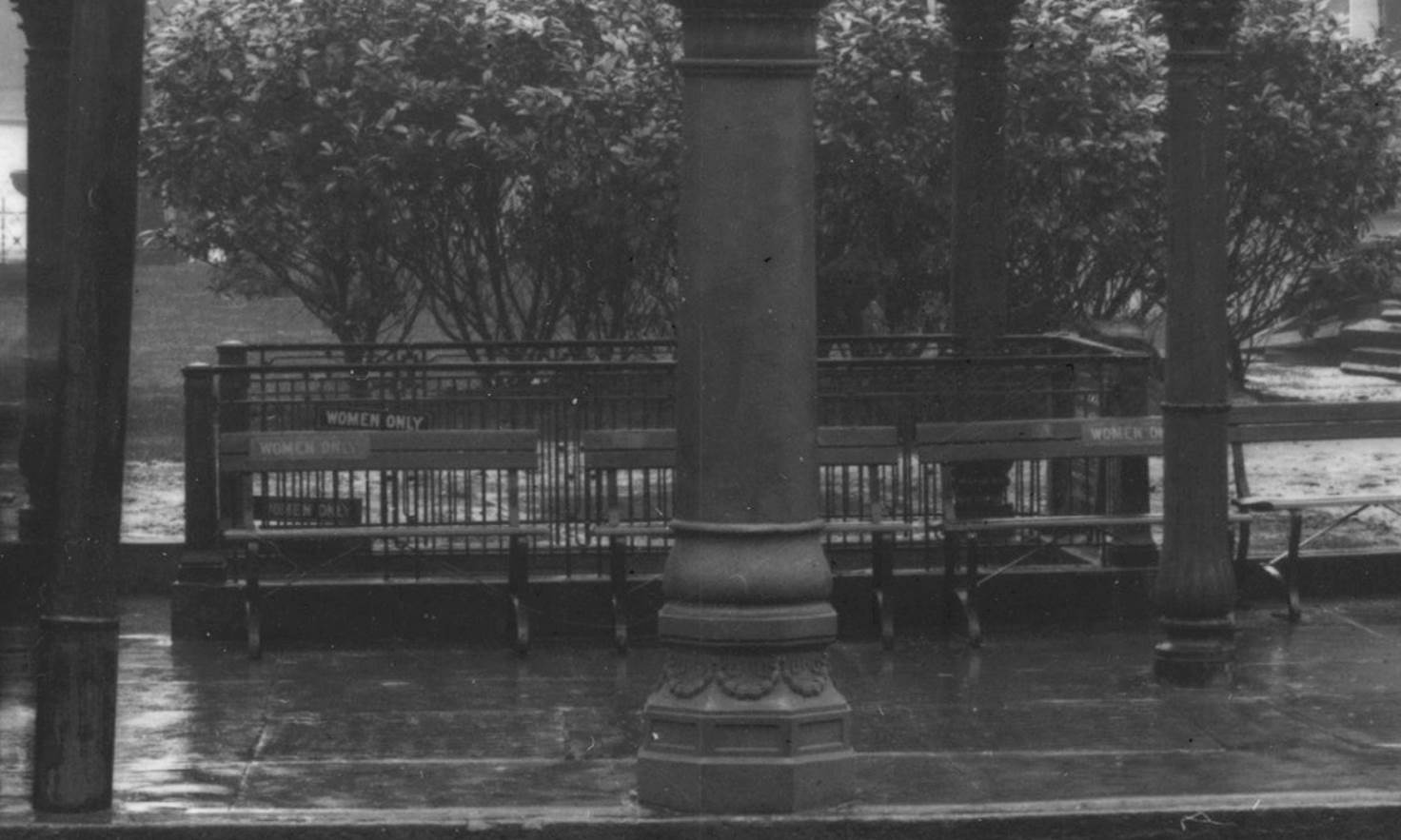
The Pioneer Place pergola on a foggy day. Note the fenced stairwells leading to the underground toilets. (MOHAI)Detail of a stairwell – the west side for “women only.” (MOHAI)This floor plan for the underground restroom is from David Williams’ blog GeologyWriter.com by way of theater historian David Jeffers.This 1970s image of the vandalized restroom appeared in an Oct. 27, 1996, centennial section of the Seattle Times: https://special.seattletimes.com/o/special/centennial/october/saving.htmlExcavation prior to construction of “sinking ship” garage, Sept. 2, 1961, Seattle Times, page 3.
THEN: The President Hotel rises on Olive Way in 1937-38, in this assessor’s photo rescued among thousands of others by now-retired county employee Stan Unger, of Magnolia. Below right, a New Richmond Laundry truck services the President, trumpeting Zoric fluid, “the most revolutionary dry cleaning process of all time.” The motherly laundry’s longtime slogan: “Sox, we darn ’em.” (Courtesy Stan Unger)NOW: With Interstate 5 to their backs, descendants of Matthew Zindorf stand socially distanced at the former President Hotel site: (from left) Audrey and Adrian Tarr, Christine Brauner and Christine and Gus Marshall, all of South Seattle. (Jean Sherrard)
(Published in the Seattle Times online on Jan. 14, 2021
and in PacificNW Magazine of the print Times on Jan. 17, 2021)
Builder Matthew Zindorf once installed a prudent President
By Clay Eals
On the cusp of Wednesday’s inauguration in Washington, D.C., we at “Now & Then” unequivocally commit ourselves to a peaceful transition — to a pertinent Seattle subject.
We reference, faithful readers might have guessed, the President Apartment Hotel. This seven-story brick building served a 34-year term from 1927 to 1961 while perched northeast of downtown on Olive Way atop what today is Interstate 5.
Though an elegant edifice, this was no overnight abode for the likes of Hoover, Roosevelt, Truman, Eisenhower or Kennedy, as its name could imply. With 36 single rooms and 58 two-room suites, each with pull-down wall beds, the President hosted longer stays starting at $30 a month.
Upon its opening, newspapers rallied public support. They touted electric refrigeration, radio outlets and hardwood floors and lauded “automatic elevator service to all floors,” including a basement garage, “doing away with the sometimes unpleasant necessity of going out of the building to reach the car.”
Matthew P. Zindorf as a young adult. (J.H. Blome Studio, courtesy Leon Blauner)
Headstrong entrepreneur Matthew P. Zindorf both designed and owned the President. Known as an engineer who constructed Seattle’s first reinforced concrete structure (the 1910 Zindorf Apartments, still standing at 714 Seventh Ave.), he had developed major projects here and in Canada since 1890.
He also dabbled in public policy. In three 1934 letters to The Seattle Times, he proposed how to cast off the Depression: “I would keep every honest, willing worker at work. No children nor women would be needed. I would begin to reduce the hours of the employed to give work to the unemployed. I would keep them employed all the time.”
Politics on the home front earned him tabloid-style coverage in 1929. “Wealthy Realtor Sued for Divorce On Cruelty Charge,” bellowed The Seattle Times, as Zindorf conceded custody of a daughter, a house and alimony. A Seattle Post-Intelligencer subhead said his wife, Daisy, complained that “She Did Own Housework To Save Money.” Daisy reportedly testified that Zindorf had canceled her charge accounts, limiting her to spending $80 a month to run their household with no help. Zindorf’s side went unreported.
Zindorf died in 1952 at age 93, stepping down from work just three years earlier. While residing at the Elks Club, he often walked downtown with grandson Leon Brauner, now of Ocean Shores, who recalls, “Every time we passed a particular Fourth Avenue bank, he whacked his cane against the plate-glass window.” His granddad’s rationale is a fuzzy memory, but surely “it was his way of making a point.”
Power-cranes clawed away the President’s walls in March 1961, declaring another victory in the inevitable campaign to build I-5. Pardon the expression: All in favor?
WEB EXTRAS
To see Jean Sherrard‘s 360-degree video of the “Now” prospect and compare it with the “Then” photo, and to hear this column read aloud by Clay Eals, check out our Seattle Now & Then 360 version of the column!
Our automotive informant Bob Carney discloses that our “Then” photo depicts (from right) a 1928-29 Ford Model A panel truck, a 1929-30 Chevrolet coupe and a 1935 Ford Tudor. The car at far left is unidentifiable.
Below are an additional photo, a map and, in chronological order, 38 historical clippings from The Seattle Times online archive (available via Seattle Public Library) and other online newspaper sources that were helpful in the preparation of this column.
As a bonus, at the bottom, we include 27 additional clippings that convey the creativity of the anonymous advertising copy writer for New Richmond Laundry, who certainly wasn’t depressed during the Great Depression!
Special thanks to Leon Brauner and Diana James for their assistance with this column!
Matthew P. Zindorf as a young adult. (J.H. Blome Studio, courtesy Leon Blauner)A section of the 1912 Baist map shows the future location of the President Hotel, indicated by red arrow. (Ron Edge)July 24, 1905, Seattle Times, page 10. This ad indicates a five-room cottage stood on the site where the President Hotel was later built.Sept. 3, 1911, Seattle Post-Intelligencer letter to the editor, page 7.March 24, 1913, Seattle Times, page 19.May 2, 1926, Seattle Times, page 80.July 18, 1926, Seattle Post-Intelligencer, page 35.Sept. 18, 1926, Hotel News of the West. (Diana James)Feb. 20, 1927, Seattle Times, page 14.Feb. 1, 1928, Seattle Times, page 2.Feb. 15, 1928, Seattle Times. (Diana James)Dec. 3, 1928, Seattle Times, page 28.June 20, 1929, Seattle Times, page 7.June 29, 1929, Seattle Times, page 2.Oct. 11, 1929, Seattle Post-Intelligencer, page 19.Feb. 15, 1931, Seattle Times, page 3.May 11, 1933, Seattle Times, page 24.Aug. 7, 1934, Seattle Times letter to the editor, page 6.Sept. 1, 1934, Seattle Times letter to the editor, page 6.Sept. 17, 1934, Seattle Times, page 6.May 8, 1936, Seattle Post-Intelligencer, page 10.Feb. 27, 1945, Seattle Post-Intelligencer, page 15.May 18, 1945, Seattle Post-Intelligencer, page 19.June 22, 1945, Seattle Times, page 19.Oct. 14, 1945, Seattle Post-Intelligencer, page 33.March 1, 1946, Seattle Post-Intelligencer, page 21.Feb. 16, 1952, Seattle Times, page 12.April 13, 1952, Seattle Times, page 30.July 5, 1953, Seattle Times, page 25.Dec. 30, 1955, Seattle Post-Intelligencer, page 26.Sept. 21, 1959, Seattle Post-Intelligencer, page 1.Oct. 31, 1959, Seattle Post-Intelligencer, page 16.Jan. 2, 1960, Seattle Times, page 17.March 15, 1960, Seattle Times, page 25.Oct. 28, 1960, Seattle Times, page 21.Oct. 29, 1960, Seattle Post-Intelligencer, page 5.Oct. 30, 1960, Seattle Times, page 52.Nov. 5, 1960, Seattle Times, page 18.Dec. 3, 1960, Seattle Times, page 21.March 9, 1961, Seattle Post-Intelligencer, page 5.
New Richmond Laundry ads
Here is a selection of 27 creative classified ads for New Richmond Laundry, whose truck appears at bottom right in our “Then” photo. At the very bottom are an article and ad for Zoric, the fluid touted by New Richmond Laundry.
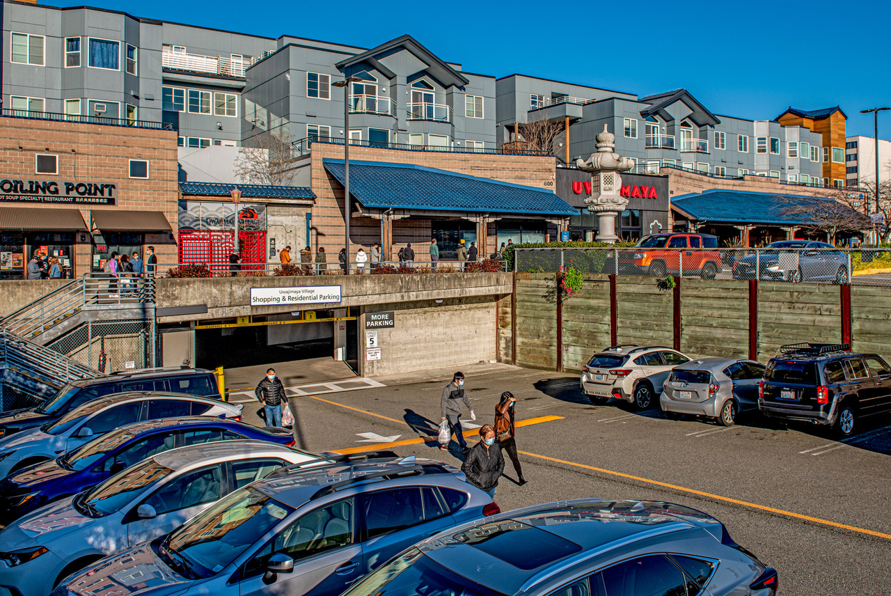
THEN: To accommodate fill dirt expected from the Jackson Street regrade, pre-existing structures like these hotels near the southeast corner of Sixth and Weller were lifted by their owners onto posts. After the regrade, the incline between Twelfth and Fifth avenues was reduced to less than 5% grade from the previous 15%. This photo was taken on May 20, 1908, halfway through the project. (Lewis & Wiley, courtesy Ron Edge)NOW: Shoppers line a walkway between Fifth and Sixth avenues in the Chinatown-International District in early December 2020. Photo historian Ron Edge positions the “Then” hotels just inside the walls of today’s Uwajimaya Village at right. (Jean Sherrard)
(Published in the Seattle Times online on Jan. 7, 2021
and in PacificNW Magazine of the print Times on Jan. 10, 2021)
Sluicing away Jackson Street to unclog the city’s future arteries
By Jean Sherrard
Long before becoming a student of Seattle history, I had a recurring (and oddly unsettling) dream of hiking an unbroken ridge between First Hill and Beacon Hill. Were it not for Reginald Heber Thomson (1856-1949), our city’s current topography may have matched my dreamscape.
THEN 2: Reginald H. Thomson, Seattle city engineer, in 1905. (courtesy, Seattle Municipal Archives)
When Thomson first stepped onto Seattle docks on Sept. 25, 1881, he told a friend that the city was built in a hole and he meant to dig it out. The 25-year-old’s ambition might have been attributed to youthful exuberance, but in the decades to come, his words would prove prophetic. Appointed city engineer in 1892, Thomson began by installing water and sewage infrastructures (still in use today) before attacking Seattle’s hills and valleys.
Notes David Williams in his masterful 2015 history of Seattle topography “Too High and Too Steep,” to Thomson “a functioning city was like a human body.” He insisted that “enlarging and improving what he called the city’s arteries” was vital to Seattle’s future health.
A view from lost Denny Hill, looking north to Magnolia
Picturesque piles of glacial deposit — like Denny Hill north of downtown — were, in Thomson’s view “an offense to the public,” interrupting the free flow of traffic. In 1898, the hill’s decapitation commenced, using hydraulic hoses (called “giants”) to liquify and sluice away the moraine.
One of the “giants” in action (courtesy Ron Edge)
When Rainier Valley residents complained that the Jackson Street incline’s steep 15% grade obstructed access to Seattle’s business district, Thomson lent a sympathetic ear. Intrigued by their initial suggestion to tunnel through the hill, he eventually advanced a “far cheaper and far better” solution — utter removal. “Every house and every garden and every street” in the affected areas might be lost, but he judged the sacrifice necessary to make municipal headway.
Looking east from the corner of Weller and Maynard
In May 1907, the hydraulic giants began their work. Enormous pumps fed up to 25 million gallons of salt and fresh water daily to their pressurized hoses, expelling a thousand cubic yards of dirt during each eight-hour shift.
Another view looking west from Eighth and Weller
Completed in December 1909, the Jackson Street project covered the largest surface area of all Seattle regrades: 56 blocks in total, with 29 lowered and 27 raised. More than three million cubic yards of dirt were moved, lowering Ninth and Jackson by 85 feet and raising Sixth and Weller by about 30.
My recurring dream may harbor some whiff of lost geography, yet the force of R.H. Thomson’s vision resides. While often trading natural beauty for an engineer’s expedience, his straightened, flattened, stretched Seattle provided a blank canvas for cityscapes to come.
WEB EXTRAS
To see our Now & Then featured in spectacular 360 video, along with an audio narration by Jean, click here.
A few more regrade-themed spectacles below:
A western view of the regrade, with King Street station’s clock tower just right of center