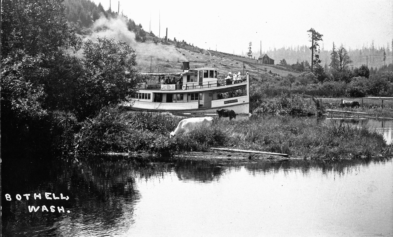
THEN: Looking north over Squak Slough (aka the Sammamish River) and the Blyth farm ca. 1900. The barn stood near what is now the tee for the 18th hole of the Wayne Golf Course.NOW: Left-to-right, knowledgeable Squak Slough historians Dean Jowers, Margaret Turcott, and Sue Kienast, pose for Jean with their backs to the narrowed waterway. Pilings for the Waynita Way bridge appear on the right.
When first glimpsed, this week’s “then” charmed me with a classical restraint that is softly repeated, upside down, in Squak Slough. Especially satisfying are the comely barn, the blooming fruit tree and the saw-tooth horizon strung with surviving fir trees that for reasons only known to sawyers were earlier rejected by the clear-cutting lumber jacks. We are also puzzled why the unnamed photographer chose to have the farmhouse roof rise above and seemingly out of the barn. They seem to be attached, but, of course, are not.
Although minimal, the caption penned on the negative is, of course, most helpful. It gives the indigenous name for the waterway we are now more likely to call the Sammamish River. Wondering where on the slough/river and by whom this farm was built, Jean and I sought expert help by first printing this Sunday’s photo in our blog dorpatsherrardlomont. Dean Jowers, a Redmond Historical Society volunteer, read the posting and took the challenge. With a print-out of this farm-scape in hand the retired operations manager, with a talent for details and spatial relations, hiked the fourteen miles that the slough courses between the two big lakes: Sammamish and Washington. In the beginning of his search, Jowers confesses, “I started at the wrong end of the river and was first wrong three times.” But then with the help of a 1919 topographical map, he found the horizon line. It registered the slight dent – or slump – above the farmhouse seen in the featured photograph at the top.
The Acme, one of the shallow steamers that moved passengers and goods on Slough. Note the familiar barn just above the two men on the steamer’s bow, and the familiar farmhouse on the left.
In Jean’s repeat, Dean Jowers poses for the “now” with, left-to-right, Margret Turcott and Sue Kienast, both energetic members of the Bothell Historical Society. They confirm Jowers’ research. This a little more than two miles above the Slough’s outflow into Lake Washington. The “then” photo was taken years before Lake Washington was lowered nine feet in 1916 with the building of the ship canal. In spite of the drop, the slough is still slow moving.
This is John & Christina Blyth’s Farm. At the urging of her brother Mattias Bargquist, the thirty-three year old Christina emigrated from Sweden in 1884. She soon met her future husband John Blyth, who was her brother’s friend and “next door” neighbor across the Slough. Perhaps there was some romantic maneuvering and conjugal conspiring involved in this meeting, for John accompanied Mattias on the lake steamer that first delivered Christina from Seattle to their farms facing across the Slough. John soon married Christina in their family home on March 11, 1885. Margaret Turcott tells this and other Blyth and Bothell stories well in her new book titled “Bothell” to be published this coming August. Dean Jowers suggests that the bridge showing on the right was built by these intertwined families for their friendly visits.
WEB EXTRAS
Anything to add, fellahs? Yes Jean, we will not disappoint you. Like candidates in a voters guide or totem figures on a pole we will stack below some features, old and older, that might lead one directly or eventually to the little river that runs between Bothell and Redmond.
THEN: Ballard dairy farmer Jess Jensen poses with four of his milch cows on 8th Avenue Northwest, near its intersection with NW 58th Street. The subject looks north.NOW: Holding his book “The City Is More Than Human,” historian Frederick L. Brown, poses for Jean Sherrard in the traffic on 8th Avenue NW. Brown only seems to be in danger. The cars behind him have been stopped by the traffic light at NW 58th Street.
Here stands historian Fred Brown holding his new book and farmer Jess Jensen holding the roped reins attached to his four cows. The two-legged animals pose near one another and the intersection of NW 58th Street and 8th Avenue NW, although across about a century of time. Before Ballard’s 1907 annexation into Seattle, 58th was named Times Street (not knowing other or better, I propose that it was named for this newspaper). Resting comfortably at the base of Phinney ridge, Eighth Avenue, then called Division Street, served as Ballard’s eastern border.
Jesse and Kjerstine Jensen were Danish immigrants who built their home in Ballard in the 1890s. Like most of Ballard’s first flood of citizens, Jesse easily found hard but sustaining work with a lumber mill on Salmon Bay. He signed on with one of the largest, the Ballard Stimson Mill. Soon, however, the couple built their Ballard farm, raising primarily chickens, pigs and cows. Kjerstine handled the business of the farm. The milk was both sterile and popular, selling at a nickel a quart. Anna, the couple’s daughter, recalled “My mother sold quite a lots of chickens, young fryers. They’d come and get them and she’d kill them (the chickens) right while they (the customers) were there (waiting).”
If Fred and Jesse could have bridged the century here at the corner, the historian might have first asked the farmer for the names of his cows. Surely they all had them. While paging through his book and pausing at page 58 where this snapshot of Jensen and his bovine quartet is printed, the historian Brown would not have missed the chance for asking the builder-farmer for the photo’s date. Perhaps it was 1907 or soon after. One of the first freedoms lost that year with Ballard’s annexation into Seattle was a cow’s liberty to wander the neighborhood. Here Jesse has his milch cows roped. Perhaps they are regulated, posing together not in Ballard but in Seattle. Whichever. Brown notes that the Eighth Avenue in the snapshot is still more an inviting pasture for the couple’s cows than a paved arterial.
While I do not know where this familiar cow was being milked, I have used the photo in another blog story about a Moclips mystery (One can probably keyword it.) And here we use it again for a “familiar scene” in Ballard.
Brown clarifies the telling title of his book, The City is More Than Human, with a subtitle, An Animal History of Seattle. For now, I cannot think of a good analogy for his history except to note that once you have read The City Is More Than Human, you may feel that you have been talking with its subjects: beavers, cougars, cattle, cows, horses, dogs, cats, pigs, chickens and salmon.
The Auckland Dairy, not in Ballard but across Salmon Bay up the ridge in Magnolia. (Courtesy, the Magnolia Historical Society)Julia Zaunder with the family cow on the side lawn of their Belltown Home on First Ave. North.Several pets on the front steps of the Lowman Home at the southeast corner of Marion Street and Boren Avenue ca. 1890. (Courtesy, Michael Maslan)Caged poultry on a ride.
If you have pets, children with pets, back yard chickens (properly cared for, they are allowed), or an active good will for animals, you may well want to read this book. Author Brown suggests that it may both help you “see how animals fit into history” and also spur you to “consider how to live amongst animals today.” (To note its own pedigree, Brown’s book is published by the University of Washington Press with the assistance of a grant from the Weyerhaeuser Environmental Books Endowment.)
You will find this portrait of Morris the Cat on the facing page to Fred Brown’s Fourth Chapter, titled “Dogs and Cats Loving Pets in Urban Homes.” Morris, of course, was also a publicist, which reminds us to credit his portrait to The Gary Tolam Collection at the Museum of History and Industry, aka MOHAI.
WEB EXTRAS
Anything to add, dawgs? YUP JEAN links galore or more of the same, we mean features, old and not-so-old that touch on this week’s subject and its Ballard home.
========
=====
=====
=====
=====
=====
=====
=====
=====
=====
=====
=====
=====
=====
=====
=====
MISC-INTERSPECIES ILLUSTRATED
Another (see above) from the Loman Album: a scene from First Hill, ca. 1890.Looking East on John Street from near Aurora (before the speedway), from the Brown Family collection, ca. 1905. .One of the many Pike Market pigs, photographed by Jean Sherrard.Another “Moclips Cow“In its time the hip confectionaire Pig-N-Whistle at 1009 2nd Avenue.
Mercer School, Lower Queen-Anne, can you find the cow?Another Belltown CowAnother Moclips, it seems, milkerWallingford Watch Dog, 4500 block on Bagley, Sept. 27, 2006Ballard fish trapBallard fish preparation
THEN: The Margaret and Mary Ann Denny home spent its waning years, first in 1925 as The Chateau with rentable “accommodations for particular people in the most beautiful residence on First Hill,” followed in 1926-27 as The Hospitality Club, advertised as “for young business girls and students.”NOW: Architect Earl W. Morrison’s Marlborough House assumed the corner in 1928. In an advertisement from January 24, the hotel’s management was already confident that “To live at Marlborough House is a mark of social distinction.” They were right.
While I do not know the exact date for this portrait of Margaret Denny’s First Hill home, it can be compared to another and similar photograph that appeared in the “Real Estate and Business News” section of The Seattle Times for July 1, 1901. The newspaper’s caption reads, in part, “The accompanying halftone is a representation of the new Denny Home … one of the most sightly spots in the city.” I think in this instance “sightly” means both “good to look at” and “good to see from.” Understandably, the latter connotation was used repeatedly for promoting the Marlborough House Apartments, seen in Jean Sherrard’s repeat, which succeeded the Denny home in 1928. From the Marlborough’s ten stories one could take in panoramas of both the Cascade and Olympic Mountains and the continued proliferation of other First Hill apartments as they more often than not replaced single-family homes, some of them near-mansions similar to the Denny Home.
A clip from The Times for July 7, 1901
The Times’ caption for its 1901 halftone continues, “The building was erected according to designs prepared by architects Charles Herbert Bebb and Louis Leonard Mendel … It is of brick and is of the Elizabethan Gothic style of architecture.” In their essay on Bebb and Mendel in “Shaping Seattle Architecture,” a UW Press book, architectural historians David A. Rash and Dennis A. Andersen credit Bebb and Mendel with building “the most prominent architectural practice in Seattle during the first decade and a half of the 20th Century.” First Hill was increasingly dappled with their creations. In the spring of 1900 The Times credited Bebb with drawing Margaret Denny’s new home, adding that it was “perhaps the handsomest dwelling commenced this year.”
The footprint for Margaret Lenora Denny’s home appears near the center of this detail from the 1912 Baist Real Estate Map. It sits on lots 1 and 4 of block 116 of her parents, Arthur and Mary Denny’s Broadway Addition at the Northeast corner of Boren Avenue and University Street. For some unknown reason it has been marked by an earlier hand with a penciled “X” as has the kitty-corner kit at the northwest corner. On lots 5 and 8, sits Margaret’s brother Orion Denny’s home, another Tudor. Immediately below we join an illustrated clip on this neighbor. North across University Street on Lot 9 of Block 115 rests the banker Backus’ brick home that we feature at the bottom of this little history. Like Margaret Denny’s home, her brother Orion Denny’s residence at 1204 Boren was designed by the architects Bebb and Mendel. They sat back-to-back on the east side of Boren Avenue between Seneca and University streets.
Both the featured photograph at the top and The Times halftone look to the northwest corner of Margaret Denny’s home. Addressed at 1220 Boren Avenue, it rests on Lots 1 and 4 of Block 116 in Denny’s Broadway Addition – the southeast corner of University Street and Boren Avenue. Arthur Denny, Margaret’s father and a Seattle patriarch, named the former street in the 1850s. He hoped to build a university – and did – in the early 1860s: the University of Washington. Boren Street was named for the family name of Mary Ann Denny and her brother Carson. Arthur and Mary Ann Denny are most often described as the “Founders of Seattle” and their six children – younger daughter Margaret Lenora included – helped promote them as such. In 1901, two years after Arthur’s death, Mary Ann accompanied Margaret to their new First Hill home. The industrious daughter, an astute business woman, at the time was collecting rent then from several renters, including The Seattle Times for the new plant it was building on Denny property downtown at Second Avenue and Union Street.
Margaret Lenora* Denny *namesake for the Seattle street.A Times report from Nov. 2, 1930 on a tea scheduled for apartments in the Marlborough House.
Mother Mary Ann Denny died late in 1910. The funeral was held on the first day of January 1911, here in their First Hill home. Four years later the 68-year-old `Margaret Lenora Denny drowned in the Duwamish River with three others, after the chauffeured car they were riding in plunged into the river from the bridge at Allentown.
At the southwest corner of Boren and University, the Sunset Club was across Boren from Margaret Denny’s home.
WEB EXTRAS
Anything to add, amigos? Si For his Edge Links we conspired to include 25 links that related to the neighborhood. Twenty-sixth concludes the list not for any relevant to the Denny Home but for the sad stroke that recently closes Wallingford’s Guild 45 Theatre.
The northeast corner of University Street and Boren Avenue, across University from the Denny Home on the southeast corner. Note that this subject is a rough continuation of the one above it.
Perhaps you came for the Now & Then, which, never fear, is just below. But a couple of days ago, I came across a moth the size of a mouse, in its final hours, resting in a doorway. What a gift of watchful shadow and light.
Leslie Howells fingers provide size reference
Click to enlarge to full size:
“…And its wings…[were] developed to the limit set for them by God… There on the wall…was a great Attacus moth like those that fly birdlike around lamps in the Indian dusk. And then those thick wings, with a glazy eyespot on each and a purplish bloom dusting their hooked foretip, took a full breath under the impulse of tender, ravishing, almost human happiness.” –from ‘Christmas’ by Vladimir Nabokov
THEN: Beginning in 1876, Seattle’s downtown streets were all regraded, starting on First Avenue (aka Front Street). Here, thirty-five years later in 1911, the cutting has reached Fifth Avenue at Cherry Street. (Courtesy, Museum of History and Industry)NOW: For his “repeat” Jean Sherrard had two choices: to use his twenty-five foot extender pole to lift his camera closer to the elevation of the historical photographer, or to record Fifth Avenue looking north through its intersection with Cherry Street from the new grade made in 1911. He chose the latter.
This public works photograph looks into a regrade trench marked on its sides by the claws of the two steam shovels shaping the pit. The teams with their wagons wait patiently to be rattled while being filled with Ice Age droppings. From another photo, also recorded on February 20, 1911, we know that at least two more wagons are here out-of-frame to the right. All are pointed north down the center of
The highest assigned number, “20128” – of the three surviving shots (either taken on February 20, 1911 or less likely developed then) of work on the 5th Avenue Regrade as it enters the intersection with Cherry Street. A sign for the Crawford House is posted above the sidewalk, upper-right. We will attach below The Times Classified section on “Spirit Mediuims” below. Marked with yellow, we find Professor Ali Baba (hmm sounds familiar) from Bombay India, available for readings at the Crawford House, aka Bombay West. (Courtesy MOHAI)A Classified for an impressive handful of “spirit mediums” including Ali Baba and his readings in the Crawford House at the southeast corner of Fifth Avenue and Cherry Street in 1911.
Fifth Avenue at its new grade. Ultimately, of course, Fifth Avenue will be hard-paved – it is in the contract – but not for the comfort of horses. They prefer the mud. After a wagon’s turn comes up and it is filled, its team will turn left (west) down the freshly dug cut on Cherry Street to the paved avenues below, proceeding to make its assigned delivery, perhaps on the tideflats. The teams will try not to slip.
The same corner a little later and still looking north thru Cherry on 5th. Note that the residence on top has been lifted to blocks for moving to a new but not indicated location. Copies from The Times for March 30, 1911.
We can estimate the speed of this digging with a photograph published in The Seattle Times on March 30, 1911, “printed” above. It aims in the same angle as the featured photo from the west side of Fifth Avenue, but The Times photographer has moved on and followed the shovels’ work to the north side of Cherry Street. The stately home, near Columbia Street, seen in the featured photo at the top in the clear light just to the left of the shovel’s exhaust also appears in The Times published photo, where it is, however, set on blocks preparing for removal to some friendlier lot. The helpful Times caption also offers some context and statistics for this regrade. The Fifth Avenue Regrade reached from Washington Street to Madison Street and moved 190,00 cubic yards of earth at 49 cents a yard. (We may, again, sympathize with the horses.) The contracts for grading, sewerage, water mains, walks, lights and (to the horses potential distress) paving, came to $270,000.
The third surviving shot of the regrading at Fifth Avenue and Cherry Street. This looks south on Fifth and over Cherry.
Later in November, 1911, the work was stalled when the contractors Marks, Russell and Gallagher (their name is signed on each steam-shovel below the operator’s window) stopped digging until the city agreed to indemnify them from any further slides that might damage buildings along what was left of the Fifth Avenue Regrade. By then seven structures had been wrecked, most of them near Yesler Way. (The THIRD of the Edge Links that follow this little essay will open another feature that concentrates on the Fifth Avenue slides at Yesler that accompanied the regrading of Fifth Avenue nearer its start.)
Public works watching was a popular pastime during the early 20th-century regrading years. A line of regrade watchers seen in the featured photo on the right stand on or near Cherry Street. Soon, however, these spectators will have their platform upset when the shovels continue their clawing to the east (right) as far as Sixth Avenue where Cherry Street reaches a natural steppe, or plateau, that paused First Hill’s climbing for one block, as far as Seventh Avenue.
Above: A Times clip reporting on two renters fall into the regrade ditch while trying to move furniture from the Leland Hotel at 511 Cherry Street. The Leland Hotel’s footprint appears in red far left on the south side of Cherry Street, east of Fifth Avenue and next to the alley. This detail is from the 1912 Baist Real Estate Map. CLICK TO ENLARGE.
In this block between Fifth and Sixth Avenues the regraders exposed but did not upset the Kneeland House (aka the Leland Hotel), a red brick hostelry at 511 Cherry Street. It was three-stories high with thirty-six rooms and set on the south side of the street just west of the alley. The cutting on Cherry left the hotel about thirty feet higher, and with this difference came a tragedy. On the fifteenth of November, renter Ella Johnson, with her helper Nettie Herserma, when lowering furniture from the hotel into the new cut, the hotel’s railing gave way. The women were delivered to the Wayside Hospital in the Bonney Watson hearse, which doubled as an ambulance when not busy with “loved ones.” Struggling with a broken back, Johnson died, while Herserma recovered.
[from The Times for Sept. 21, 1912. ASK HEAVY DAMAGES – Judgment for $100,000 for the death of Mrs. Ella J. Johnston was asked in the superior court yesterday afternoon against George Nicholls, owner of a building at 511 Cherry Street, which Mrs. Johnston rented. On November 15 last a porch rail gave way beneath her weight and she was precipitated thirty feet to the ground, sustaining a broken back, from which injury she died later. James T. Lawler, administrator of the estate, brought one suit for $50,000, and the three minor children of Mrs. Johnston joined in another for a similar amount.]
WEB EXTRAS
Anything to add, mates? Many relevant links Jean – most either from the neighborhood or of other street regrades. Note, again, there is more on the Fifth Avenue regrade in the third of the twenty-seven “Edge Links” stacked immediately below.
THEN: On December 6, 1962, Frank Shaw recorded this look north from Cherry Street. The doomed structures that remained for only a few more weeks were in the chosen path for the Seattle Freeway. The block-wide line between Sixth and Seventh Avenues was chosen in the 1950s for the construction of Interstate-5’s concrete landscape through the business district.NOW: A notable surviving landmark, a large apartment building, is repeated upper-left at the northwest corner of Marion and Sixth Avenue. Embellished with bay windows, it has changed its color at least once, from red brick to a painted beige or buff. As historic preservationist Diana James discovered while writing Shared Walls, a history of Seattle’s apartments built between 1900 and 1939, it has also changed its name at least four times, beginning as the Laveta Flats in 1904, followed by the Highland, the Amon, and since the mid-1930s, the Dover. The early snapshot from the Smith Tower, below, includes the Laveta Flats (now the Dover) on the far left without its bottom two floors, and so before the regrade of Marion Street between Fifth and Seventh Avenue. The regrade is described in the fifth feature include in this weeks Edge Features below. In the photograph below most of the block featured this week can be found on the far right. This detail from from the Smith Tower (dedicated in 1914) shows St. James Cathedral, upper-right corner, with its cupola still intact, uncrushed by the heavy snow of February 1916. Far left, across Seventh Avenue from the formidable brick pile of Central School, the Laveta Flats aka Highland aka Amon and now Dover Apartments stands at the northwest corner of Seventh Avenue and Marion Street, as yet without the two floors added with the Marion Street Regrade between Fifth and Seventh Avenues. A feature treating on that regrade is included below as the fifth illustration in the “pile” of EDGE EXTRAS that follow below. Most of this week’s featured block appears far right. The record of I-5 clearing on the right looks north over James, Cherry, Columbia, and Marion Streets to the temporarily surviving wall on the north side of Marion, which was built to support a Central School brick annex.Frank Shaw’s August 15, 1964 record of the Seattle Freeway creeping south, reaching as far as Jefferson Street.
This Sunday’s feature is another witness to photographer Frank Shaw’s interest in the changes to our cityscape that came with the building of the Seattle Freeway on the western slope of First Hill. Through its construction in the 1960s, this part of the I-5 Freeway kept to a block-wide swath between Sixth and Seventh Avenues. Shaw dated this example of his Hasselblad’s work December 6, 1962, a mere fifty-seven years ago.
Fire Dept headquarters at the southwest corner of Columbia and 7th Avenue photographed by A. Wilse in the 1890s. (Courtesy Museum of History and Industry)
PacificNW first visited this block with another now-and-then feature pulled from the Shaw collection that showed the sunlit façade of the same brick and stone building whose back fills most of this week’s feature. Located at the southwest corner of Columbia Street and Seventh Avenue, it was the Seattle Fire Department’s new headquarters built soon after the city’s Great Fire of June 6, 1889. We may speculate that the preservationist in Shaw took his earlier photo in admiration of his subject’s substantial architecture, as well as it distinguished past. Dated August 6, 1960, it was first printed in Pacific on Sunday, January 19, 2014. (Shaw’s colored shot of the fire station and the 2014 feature that interpreted it, are included below as the first of the many Edge Extras that follow Jean’s question below “Anything to add, blokes?)
A detail from the 1888 Sanborn real estate map showing block 304 bordered by Columbia Street at the top and 7th Avenue on the right. The first two parts of the row built along the west side of 7th Avenue take lots 11 & 12. The back-porch is included with a dashed line. Lots 5-thru-8 would be taken by the fire station. The house on lot 15, facing Cherry Street, would survive 70-plus years of changes in the block.The featured block in this detail from the 1912 Baist Real Estate map is No. 47. Here the row at the northwest corner of Cherry Street and Seventh Avenue has grown to include five residences. The brick Monticello Hotel is just north of the row and the fire department headquarters north of the hotel.
The more “in your face” subject in the feature at the top is the collapsing rear stairway of the three-story apartment row that in time strung five addresses together on the west side of Seventh Avenue, north from its corner with Cherry Street to the Monticello Hotel. Construction of the row began in the late 1880s, but not at the corner. Footprints of its first two flats, the most westerly units of the row, are drawn in the 1888 Sanborn Fire Insurance map. (Included here two illustration up.) These two were built on the largest of the row’s five lots, and their roofs distinguished them from the addresses beginning at Cherry Street. It seems fitting that the
This detail pulled from a c.1913-14 panorama taken from the then new Smith Tower includes most of the block. The five-part row begins on the far right with a pointed tower above the northwest corner of Cherry and Seventh Avenue. The rows fourth part, near the center of the detail, has its unique – for the row – roof. The back-porches here are the same as those failing in the featured photo at the top. The fire station and its tower are on the left with the brick Monticello Hotel sitting snug between the row and the fire station. (CLICK to ENLARGE)Lawton Gowey (again) took this look at First Hill east from the Smith Tower on June 6, 1921. The featured block appears on the far left. It is still intact, but not for long. James Street climbs the hill at the center of Lawton’s snap. Fifth Avenue is at the bottom. CLICK TO ENLARGEThe featured block’s northern half selected here from a 1950 aerial. Some of the Coo Coo Row appears on the above-center right. The Yale Apartments fill the block’s northwest corner at Columbia and Sixth Avenue. (Courtesy MOHAI)
often generous flow from the First Hill springs that supplied pioneer Seattle are shown rushing across the intersection of Seventh Avenue and Cherry Street in the 1878 birdseye view of the city. Perhaps the centuries-old fluid dynamics at this corner had something to do with the eleventh-hour settling of the Coo Coo’s back porch.
The featured block bordered by Sixth and Seventh Avenues and Cherry and Columbia Streets. A detail is first selected here from Seattle’s 1878 birdseye, and followed by the entire lithograph. (Click Click to Enlarge.) Note the route of the creek (with bridges) cutting across the upper-right corner of the detail and hence through the featured block.
The recent revelation of the row’s last name, Coo Coo, seems to us both appropriate and surely silly. The name of the apartments and the tavern at the corner appear in my copies of the Polk City Directory for 1938 and 1950. In the 1938 edition the Coo Coo’s proprietor, George H. Thomas, lives at 701 1/2 Seventh Avenue, and so perhaps above the Tavern listed at 701 Seventh Avenue. We learn from a Times clipping for May 12, 1944, that both George and his wife Ethel had their tavern license suspended for twenty days for their “purchase of improperly stamped beer from an unlicensed wholesaler.” This, I’m guessing, was a profitable racket learned during Prohibition and continued afterwards.
WEB EXTRAS
Anything to add, blokes? Yup Jean, and its again more features (relevant or appropriate) that we unload on your digity-dock.


mr-THEN")


![THEN: Looking north-northeast from a low knoll at the southwest corner of Seneca Street and Seventh Avenue, circa 1916. By 1925, a commercial automobile garage filled the vacant lot in the foreground. [Courtesy, Ron Edge]](https://i0.wp.com/pauldorpat.com/wp-content/uploads/2014/11/seneca-7th-mr-then.jpg?resize=474%2C353&ssl=1)


 ========
 =======
