THEN: Carolyn Marr, Museum of History and Industry librarian and Anders Wilse expert, answers the joking caption on Councilman Reinhard’s pant leg with another example. “Wilse had a wry sense of humor. In one photo he took during the Great Northern Railroad construction project, a group of 4 men sit around a table playing cards with revolvers and glasses of liquid. He wrote on the photo ‘A Merry Christmas.’” (Courtesy Seattle Municipal Archive)NOW: Author-editor and friend Clay Eals accompanied Jean Sherrard to the new Queen Anne Standpipe to take Reinhard’s place. Clay is drinking Cedar River water drawn from his own tap. Above him is 2 million more gallons of it. (photo by Jean Sherrard)
For more than thirty years I have included this Anders Beer Wilse image in slide shows. It always amuses. Typically, I explain to those in attendance “Here are two members of the Seattle City Council ‘testing Cedar River Water’.” They answer with incredulous variations of “Oh really!”
“Testing Cedar River Water” is written clearly across the pants of the one tipping the bottle. Who is he, where is he and when? I did not know. But now with a little help from friends and fellow heritage travelers I do and it can be told.
Anders Wilse was hired in 1899 by Seattle Public Works to photograph work-in-progress on the Cedar River gravity system. Anne Frantilla, Seattle’s Deputy City Archivist, notes that the Norwegian photographer’s negative number “80.x” is also written on a pant leg. Deducting from other numbered Wilse negatives and also from news clippings of the city council’s long tour itinerary for this Tuesday, we may conclude that our two “inspectors” are joyfully lifting their arms on top of Queen Anne hill beside its then new standpipe. It is early in the afternoon of May 1, 1900.
Using group photos and newspaper election-time mug shots Jodee Fenton and Carol Lo of the Public Library’s “Seattle Room” have identified these two transplanted Oregonians as the newly elected Scott Benjamin on the left and the third term councilman William V. Rinehard tipping the bottle – but a bottle of what?
Fred Cruger and John Cooper, two antiquarian beverage experts, think they know, and independently. That is a long-necked, foil-capped bottle of a malt-extracted low alcohol drink that Rinehard is sampling. It was promoted as healthful, and new mothers were advised to use it to enrich – or fortify – their breast milk. Consequently, it was most likely not pure Cedar River water, which was still months from reaching Seattle, that councilman Rinehard was chugging.
(Please Click once and then CLICK AGAIN to enlarge.)
The most likely near-beer toast to Cedar River Water shown and described above is one joyful moment in the history of Seattle’s efforts to have clean water beyond fetching it with a bucket from streams and/or the springs that once flowed from First Hill and have since been redirected into the city’s sewerage system. The limiting date here – ca 1996 – is “confessed” because what follows, with a few small exceptions, is copied from the Building Washington, A History of Public Works that Genny McCoy and I wrote and published in the 1990s. We worked on it for about eight years, and were rewarded with The Governor’s Writers Award for 1999. (Imgaine, the governor hugged us before about 100 admiring book lovers.) Of course, much has happened with Seattle’s waterworks since 1996 (or so) but you will not find that below. Ron Edge – of Edge Clippings – has been speculating or murmuring that perhaps we should make a PDR file out of the entire book. If so we could then try some updates for the subjects – like this one. (One can also check historylink.org and see how they have developed this story.) Some of the photos included here were scanned from the book, others from negatives. It should be obvious which are which. We will begin with Seattle’s first two photographs, which are also waterworks related. This is explained in their captions copies here directly from the book.
HISTORY of the SEATTLE WATER DEPARTMENT to ca.1996.
Seattle’s first Euro-American settlers picked Alki Point for its proximity to salt water, not fresh. From the Point they could see in all directions and there was also a security in being easily seen -especially by other Midwesterners searching for homesteads. But the spit was dry. Within a half year, most of Seattle’s original pioneers fled across Elliott Bay to a hill sprouting with springs. The generous hydraulics of their second choice came from the aquifer that flowed below glacial hills and was replenished by the region’s reliable rain. This easy water helped convince Henry Yesler to set up Puget Sound’s first steam sawmill on Elliott Bay in 1853. (See Waterways Chapter – but for that you will need the book “Building Washington” for now.)
John Leary, a sometime partner of Yesler, was one of a group of local movers who first attempted in 1881 to build and organize an integrated distribution system. The Spring Hill Water Company diverted spring water into a dozen or so wooden tanks along the ridge between First and Beacon hills and laid some sizable water mains beneath the business district’s principle streets. However, the most auspicious moment for the future of community water that year was the September 25 arrival of Reginald H. Thomson. At daybreak the young teacher stepped from the steamer Dakota onto Yesler’s Wharf and was greeted by Yesler himself. Besides his baggage, Thomson carried ashore a predisposition to public service and a fervent belief in the importance of fresh water. “Clean water and sufficient water is the life blood of a city,” he liked to say. “My father drilled that into me.”
In the year Thomson came to Seattle his cousin and host, city engineer F. H. Whitworth, advised the city council that the Cedar River was the best potential source for an abundant supply of pure community water. However, in 1881 the council’s interest in building a water utility was as remote as the recommended river, which flowed from Cedar Lake some thirty-five miles southeast of the city. The council chose to rely on the bubbling wells of Spring Hill instead. With the boom in Seattle’s population throughout the 1880s (and well beyond them) the company’s wells were not enough so it built a pumping plant on the west shore of Lake Washington (now the site of Colman Park), and began pumping lake water to its new Beacon Hill reservoirs in 1886. Still the company could not keep up with the city’s requirements. When its delivery was much less than heroic on June 6, 1889, the day thirty-plus blocks of the business district burned to the ground city leaders responded.
The bust of R.H. Thomson looks down at the Headworks, which is the dam, for the city’s gravity system. It is still being constructed here. The date is Nov. 14, 1899 and A. Wilse was the photographer, as he was for many of the subjects included below. His negative number for this is “48x”.
For the price of $352,265.67 the city purchased Spring Hill’s system and the responsibility of supplying its 12,000 customers. The remainder of Seattle’s 42,000 citizens (in 1890) were serviced either from their own wells or by smaller water companies which the city utility eventually subsumed. Shortly after the fire destroyed most of downtown in 1889, Seattle Mayor Robert Moran hired Chicago waterworks engineer Benezette Williams to devise a plan for increasing the city’s water supply. Williams warned against relying on merely adding more pumps at Lake Washington. The lake was already showing signs of pollution. The new municipal utility installed another pump at Lake Washington anyway. R. H. Thomson became city engineer, on June 1, 1892. He forbade expansion of the Lake Washington plant and put his formidable will to the task of bringing Cedar River water to the city.
Interrupting the Black River for construction of a trench to carry the pipeline from the Cedar River below the Black River. Date is Oct. 13, 1999. Seventeen years later the Black River was eliminated with the lowering of its source, Lake Washington. by A. Wilse
During the summers of 1893 and 1894 Thomson and an assistant made several trips on the night train to Maple Valley. There they unrolled their beds in the woods and rose with the light to tramp along the line of Benezette Williams’s proposed gravity line. Persuaded that Williams’s plan for an open V-shaped flume was “very bad engineering” as well as unsafe and unsanitary, they rough-sketched a route for a buried pipeline. However, Thomson’s plans were soon buried below the hard times of the Panic of 1893. Two years later relief came from an unexpected source. Funding problems were resolved after the state Supreme Court approved the city of Spokane’ s proposal to rebuild its water system with revenue bonds redeemed solely through water utility receipts and not from the city general fund. Using the Spokane model, Thomson and his assistant, George Cotterill, wrote an ordinance for a Cedar River system to be paid for by revenue bonds. The new bonds, however, required voter approval. A contemporary characterized the election that followed as “waged with a fury scarcely equaled in any other campaign that the city has experienced. ”
Support for Thomson’s plan came from a combination of Progressives and Populists. The opposition was led by eastern capitalist Edward Ammidown. Allied with several prominent Seattle businessmen Ammidown incorporated the Seattle Power Company and proposed to build a Cedar River system that would then sell its water to the city. The well-funded privatizing forces hired bands and speakers and hurled accusations of socialism at the public utility advocates. Federal judge J.J. McGilvra, a Lincoln appointee and respected Seattle civic leader, published a letter in the Post-Intelligencer supporting Ammidown’ s plan and urging a nay vote on city ownership. This apparent setback set the stage for Thomson’s strategy. Pioneer Seattle historian Clarence Bagley noted Thomson’s “masterful fighting” qualities, and the engineer’s assistants said he hunted “with a rifle, not a shotgun.”
Laying the water main on Broadway Avenue – somewhere. This photograph is a puzzler yet to be unraveled. This line is described as connecting the low reservoir on Capitol Hill with the standpipe on Queen Anne Hill. The pipeline between them ran on Harrison Street, which is but three blocks north of the north border of the reservoir on Denny Way. Perhaps this is, then, part of that three blocks on Broadway although for 1899 it seems, to me, not as developed as I would expect. And yet there is very little in the way of photographic evidence from that early. A clue: judging from the shadows this recording of Broadway was taken looking south in the morning. Those two large homes on the right surely would have survived for a few years more before being sacrificed for commercial structures on a commercial trolley-served street. Another point: many of the earliest commercial structures were simply storefronts added to the fronts of home, facing the sidewalk, single story boxes where once there was a yard and/or front porch – of sorts.
Thomson set his sights on McGilvra. After several meetings with the city engineer, the judge ten days before the election wrote a second letter to the P-I, calling for approval of the bond issue. McGilvra then paid for the bands and speakers supporting public water. The combination of populism and respectability won the day with 2,656 votes for the measure to 1,665 against. As Thomson’s assistant George Cotterill later noted, “What we accomplished here in 1895 …within a few years every state did the same. Hundreds of millions of utility bonds were issued, interest rates were lowered, and utility bond investment was among the safest and most desirable.”
When Thomson and Cotterill emerged from the Cedar River watershed with their completed surveys in 1897, the city was alive with the stimulating effects of the Klondike Gold Rush. The following year the city acquired Landsburg for the site of its supply intake. (Shown above with Thomson’s portrait.) The timber-crib dam there was constructed on concrete piers set at an elevation of 536.4 feet, a head high enough to carry water by gravity twenty-eight miles to the city reservoirs at Volunteer and Lincoln (Broadway Playfield, Carl Anderson Park) parks on Capitol Hill. From the headworks the water was delivered a few hundred feet downstream through a 54-inch pipe to a settling basin where the flow passed through screens, initially operated manually, to remove coarser materials like sticks and leaves. Over twenty-two miles of the pipeline were constructed of wood staves bound with threaded steel bands of the latest design.
Testing the pressure on the main built along (and eventually under) Harrison Street (shown here) between the lower of two reservoirs on Capitol Hill and the standpipe on Queen Anne Hill. This view is dated Sept. 8, 1899. Negative 26x by Wilse.
On the first of May 1900 the Seattle City Council made an all-day inspection tour of the system’s facilities. The paused in Volunteer park for lunch on tables, inspected the work underway there on the high reservoir, and then proceeded to Queen Anne Hill for a look at the standpipe there. As we know from the top, two of them also at least pretended to test the Cedar River water while visiting the standpipe. They then went on to Kinnear Park to study its rustic mushroom and rest on the grass.
May 1, 1900. City Council pauses at Volunteer Park. R.H. Thomson is far left. Wilse neg. 74x.
Wilse’s Neg x73 shows City Council in Volunteer Park moments earlier.
Standing in a sturdy (or studied) line within the Volunteer Park reservoir’s construction zone, the members have spread themselves out for distinction. And R.H. Thomson has again put himself at the end, far left. Wilse, again on May 1, 1900.
The base of the Queen Anne Standpipe on Sept. 13, 1899. by Wilse.
Construction on the Queen Anne Standpipe as of Jan. 26, 1900. by Wilse
Queen Anne Standpipe on Feb. 22, 1900. by Wilse. Neg. 61x.
The Standpipe on May 1, 1900 inspected by the Council and by Wilse.
Once more our two happy council members “testing” the water. For names and more speculations see the now-then feature at the top.
The Council in the rustic fields of Kinnear Park and within the influence of its “mushroom.”
City Council on the lawn at Kinnear Park taking a well-earned break from the rigors of inspecting, May 1, 1900. by Wilse.
On Christmas Eve, 1900, the system tested so satisfactorily that on ]anuary, 10, 1901, the waters of the Cedar River were let loose into the Volunteer Park reservoir. After a decade of riotous development, during which Seattle’s population grew from 80,000 in 1900 to nearly 240,000 in 1910, a second pipeline, which paralleled the first, was added in 1909. With the two mains the Cedar system capacity increased to 67,269,000 gallons a day. Two additional city reservoirs with a 110 million-gallon combined capacity were also built atop Beacon Hill.
Another testing of the main – but where Wilse does not indicate? The date is Jan. 12, 1900.
In 1928 the Seattle utility began diverting Cedar River water to the 500-acre Lake Youngs (formerly called Swan Lake and named for Water Superintendent L. B. Youngs), seven miles west of Landsburg, for settling and storage. The following July Seattleites complained about the taste when the heavy summer draw lowered the lake level and raised its temperature. Eventually, a pipeline was added, which allowed the utility to bypass the lake when the river waters were cool and clear and did not need settling. From Lake Youngs, water was sent through the system control works where it was screened and chlorinated before being delivered to its users.
In 1923 the city completed a third Cedar River pipeline that ran parallel to the first two. A fourth line was dedicated in 1954. Its path was entirely separated from the first three lines, in part as a precaution against any disasters that might sever the triad of pipes that ran through Renton and up and along the ridge of Beacon Hill to the city reservoirs. The fourth Cedar River line, or the Bow Lake Pipeline as it was originally called, entered the city from the southwest after running west from the control works to near Bow Lake in the neighborhood of Sea-Tac Airport.
Getting water to Alki Point and the rest of West Seattle was still a problem sixty years after most of the first settlers left. West Seattle was annexed in 1907, following proclamations that the two communities were “plainly designated by nature to form one community.” However, the Duwamish River, which at the time was being developed into the Duwamish Waterway, inhibited the transport of Cedar River water to the annexed neighborhoods. The swing bridge over the Duwamish, built for wagons and trolleys in 1910, also carried the city’s main water lines to West Seattle. The effects on West Seattle plumbing were easily calculated. Whenever the bridge swung open for a boat or barge, the taps of West Seattle went dry. This intermittent service continued until the bridge was scrapped in 1918 and the mains submerged beneath the river’s traffic. The underwater solution was improved in 1924 when an 8-foot, concrete-lined tunnel was dug beneath the river and a steel main with walls three inches thick was laid within it. The desire for Cedar River water also figured prominently in Ballard’s annexation in 1907. In the “Shingle Capital of the World,” the campaign for “pure and sufficient water” was helped considerably when a dead horse was found floating in the Ballard reservoir on the eve of the election.
More water had to be crossed in the city’s extension of service to neighborhoods on the north shore of Lake Union. A pipeline from the Volunteer Park reservoir was run across the old Latona Bridge, which spanned the lake’s narrow neck to Portage Bay in line with the future 1-5 Ship Canal Bridge. Beginning in 1911 an extension of Cedar River Pipeline #2 was carried parallel to the Latona bridge on its own timber-pile span until 1916, when nearly 2,000 feet of 42-inch steel pipe were laid through a concrete tunnel built beneath the lake at the same passage.
The 1911 wash out of the Cedar River pipeline, on top, and the flooding of Renton from the combination of heavy rain and the break in the main. The bottom view looks west on Third Street from Burnett Avenue. Renton High School is on the right.
In 1906 the City of Seattle made a widely unpopular decision to allow the Milwaukee Railroad to run its electric line to Snoqualmie Pass twelve miles through the lower Cedar River watershed. Five years later on the Sunday morning of November 19, 1911, the church bells of Renton called not for worship but for escape, sending its citizens scurrying for the hills. A warm Chinook wind released a downpour which swelled the river and undermined the bridge that carried the two Cedar River pipelines just downstream from the Landsburg intake. The railroad construction along the river was determined partly responsible for making the pipeline’s own supports vulnerable. The collapsing bridge broke open both pipes, adding their volume to the already overflowing river and flooding the valley.
Summit Ave. looking north towards Republican Street intersection - now.
A water famine in Seattle followed. Citizens were encouraged to fill their bathtubs with lake and rainwater and the health commissioner’s precaution “BOIL YOUR WATER” blazoned across the front pages of the dailies. Since the limited supply in the city reservoirs was released only to the business district, entire families from more affluent neighborhoods fled their homes for downtown hotels. Schools closed for want of steam heat, and on Wednesday 2,000 bundles of Seattle’s dirty laundry were shipped to Tacoma. By week’s end water department crews had restored the pipelines.
In 1936 city officials applied for the water rights to build two reservoirs on the Tolt River. But it was almost twenty years later that the utility actually prepared to tap the river. In 1955, 650,000 people were being served by the Seattle Water Department. Water Superintendent Roy Morse-calculated that the Cedar River would be pushed to its capacity by 1970, and by 1980 about 900,000 people would be using the system. A second major source besides the Cedar would have to be used. Once the city council was convinced, it went ahead with development of the Tolt. In 1963 the river’s waters began flowing through the 25-mile Tolt River pipeline. As it turned out, Morse’s predictions were about right. In 1989 the Tolt and Cedar rivers together served over one million residents in an area whose size had grown to nearly 450 square miles. As parts of an integrated system, the two sources, plus a small amount pumped from the Highline Well Fields, could deliver up to 350 million gallons a day in 1990.
The Tolt line and beyond it the dam and behind it the reservoir. Following this short history Jean has inserted our “then and now” from Washington Then and Now, which shows the Tolt reservoir when it was being cleared for filling, and Jean’s repeat of it from 2005 (or was it 2006?).
Seattle’s water system includes Bellevue, Kirkland, and Redmond, together with a number of other cities and water districts. Each community acts as a separate purveyor purchasing water from Seattle, the wholesaler, and reselling it within its service area. Although Seattle aggressively pursued water customers to the north, the city had to be wooed for nearly thirty years to supply the Eastside. In 1937 Eastside residents petitioned the city council to allow them to connect into either the Tolt River or Cedar River lines. The construction ofa pipeline from the Cedar would have involved no insurmountable engineering obstacles. (The’Tolt waters were still a quarter century from being tapped.) But the Seattle City Council didn’t think there was enough population to support the service, and not even the prospect of $900,000 in federal employment grants persuaded them to build the connection.
Eastside residents themselves were ambivalent about requesting the gravity system to supplant their wells. In a 1939 election a new water district, which included Bellevue, voted 891 in favor and 899 against requesting Cedar River water. Seattle’s relaxed water department superintendent, W. Chester Morse, remarked, “Take as much time as you want. Every month’s delay saves this department over $15,000 dollars. We certainly are in no hurry.” Ultimately, the utility would change its mind as postwar growth brought increased water needs to the Eastside. Three years after he succeeded his father as superintendent in 1949, Roy Morse advised the city to speed its development of the Tolt River, in part to supply the Bellevue area. In 1963 that community came on line with the Seattle system’s new Tolt pipeline. Eventually, the Tolt Eastside supply line was connected with a new Eastside line laid from the Cedar River at the pump station in Bellevue’s Lake Hills district. In 1998 construction began at a 25-acre site overlooking the South Fork of the Tolt River on a filtration plant capable of filtering 120 million gallons of water a day when it opens in late 2000.
With the considerable population growth that occurred in King County by the 1980s, Seattle water department officials quickened their search for new sources of supply and their investigations into conservation methods. In 1985-86 the water department tapped its Highline Well Fields for a ready daily supply of 10 million gallons. Typically this new source was used only during the dry summer season when the average daily demand of 170 million gallons could rapidly inflate up to 300 million gallons. Restraining the public’s wasteful over-watering of residential lawns became the key to the utility’s development of a conservation program.
During the drought of 1987, the utility was forced to innovate when the level of Chester Morse Lake (Cedar Lake) dropped below the elevation of 1,532 feet – the minimum level for moving lake water by gravity. Department officials outfitted a barge with a pumping plant capable of moving nearly 120 million gallons a day from the lake into the lower-elevation pool behind City Light’s masonry dam from which it flowed into the system. The experience resulted in plans for installing a permanent on-shore version of the barge-mounted pumps. The Cedar Watershed is capable of supplying a volume considerably greater than that which it now delivers through the four Cedar pipelines. However, fish using the stream to spawn could be adversely affected, and new transmission lines would be needed if a permanent deep-water pump at Chester Morse Lake were to be useful year round. Two other possibilities for increasing supply are to add a filtration plant to the Tolt River system, making it usable during periods when heavy runoff makes the water turbid, and building a second intake on the river’s north fork.
However, even during the more severe drought of 1992, department spokesmen admitted that any such expansions were at least ten years away. In the meantime, Seattle and other Puget Sound area water departments and districts hurried work on their conservation plans as they implemented drastic conservation measures, such as a total ban on lawn watering. The reuse of treated waste water and the distribution of low flow shower heads were just two of the measures Seattle officials promoted as a way to save the 47 million gallons a day the department needed to conserve through the end of the decade.
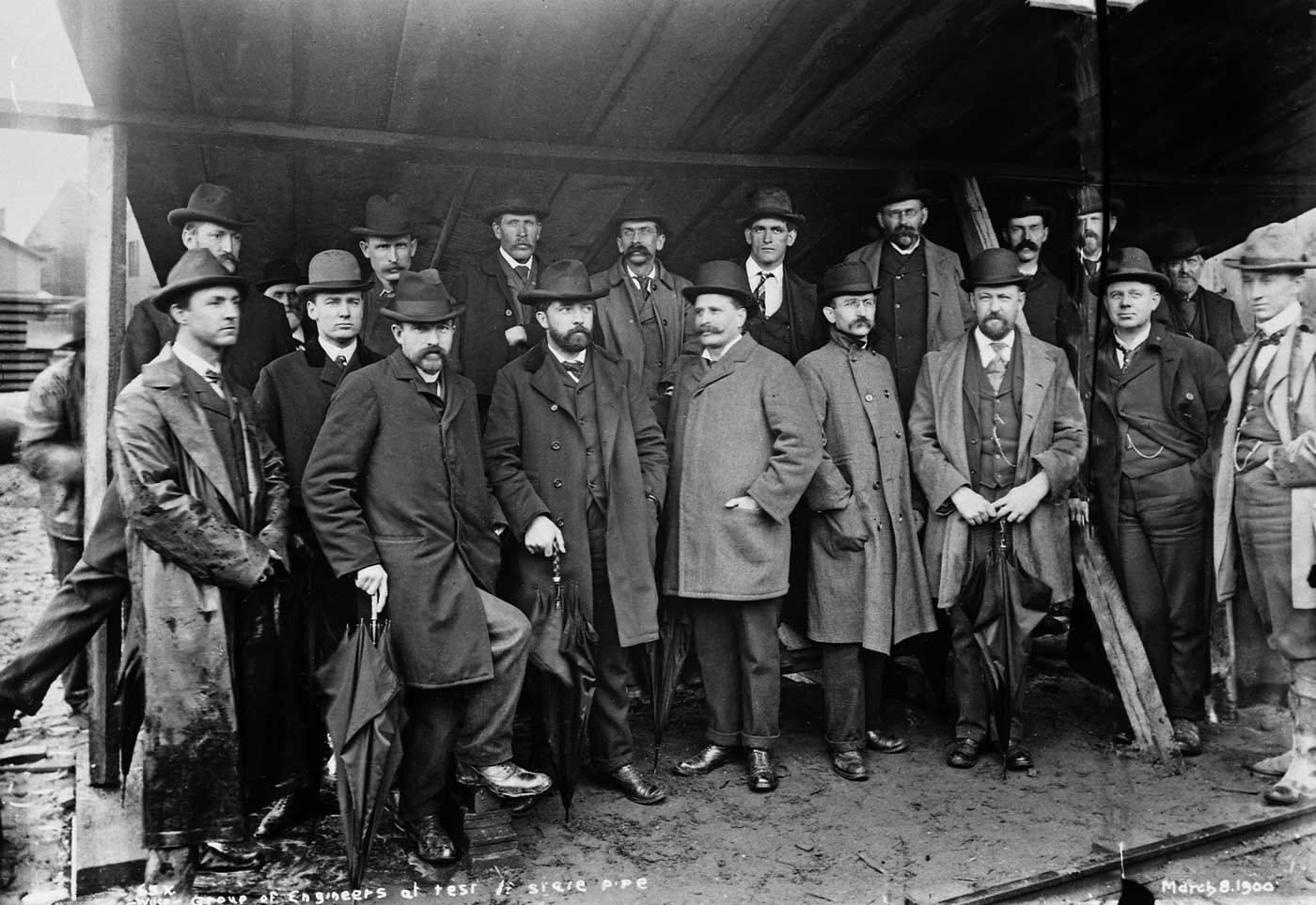
Less than two months before the City Council’s May 1, 1900 inspection, an unidentified group of Seattle-based (we assume) engineers were invited to inspect the project as well. Yes R.H. Thomson is among them, and can you find him? The date is March 8, 1900.
The following photo and its repeat directly below are one of the many comparisons Jean and I make in our book “Washington Then and Now.” It is described in greater detail on its own webpage and also appears in the “store” we have buttoned on this blog
THEN: The Tolt River pre-dam, mid-50s NOW: The Tolt in 2006
THEN: The Seattle Electric Company’s sprawling “campus” for trolleys once covered most of the two blocks between Fifth and Seventh Avenues and Pine and Olive Streets. By 1910 trolleys were being parked and repaired in new barns at places like Fremont, Lower Queen Anne, and Georgetown. (Courtesy Lawton Gowey)NOW: The monorail terminus parked above Westlake Avenue north of Pine Street may serve as a reminder of the importance of this location for public transportation. The last direct reminders of trolleys here on Fifth Avenue were erased with the 1918 opening of the Frederick & Nelson department store (now Nordstrom, at right) and seven years later the Medical Dental Building Seattle (on the left) just north of the store. (Jean Sherrard)
Starting with its simplest part – the bottom – here in a view that looks east towards Capitol Hill, a nearly new Westlake Avenue intersects on a slant with 5th Avenue.
Next, on the far side of 5th the car barns and repair sheds of the Seattle Electric Company, once the city’s trolley monopolist, are half buried.Pine Street on the right and Olive Way on the left, were both raised atop dirt “borrowed” from the nearby Denny Regrade.And so also by 1907 were most of the avenues showing here – from Fifth to Ninth.More than raised, Westlake – still at the bottom – was created or cut through the city grid from 4th and Pike to Denny Way, as we know it now. (Or rather as we knew it up until a few years ago when Westlake Mall and the rest were developed, in part, over the first block of Westlake, the part that ran from 4th and Pike on a slant through Pine to Olive.) That work began early in 1905 and was completed in November of the next year.Perhaps this view was recorded in order to show these street changes.
An approximate date for this subject is 1908.The Waldorf Hotel was completed in 1907.It is the largest structure on the right at the northeast corner of 7th and Pike.The car barn half-sunk below 5th Avenue on the far right was built in 1896 to replace another that was built in 1889 when the trolley company moved here and replaced horse power with electric.(That first plant and much else on this block was destroyed in a 1896 fire.)In a 1909 photograph of an Alaska Yukon Pacific parade, a Chinese dragon twists along in front of that barn at the northeast corner of Pine and 5th.It is significantly different than how it appears here, ca. 1908. (This dragon-parade scene with its own extended description is included below. It first appeared in Pacific, Jan 7. 1983 – more than a quarter-century ago!)
Eventually a super-sized Westlake Market used these old barns to sell groceries. It was in competition with the Pike Place Market until evicted for the 1916-18 construction of the first five floors of the Frederick and Nelson Department Store.
BLOG ADDITIONS
Looking east at the same neighborhood, but from the then new Standard Furniture big store at the Northwest corner of 2nd and Pine (Now the Rack). The seven-story Ritz Hotel, on the left, is the prospect from which the neighborhood photograph used above was recorded about two years earlier. Many other structures appear in both views. Here Pine Street leads east (up) into the center of the view.
ALASKA YUKON PACIFIC DRAGON at 5th and Pine, 1909
Looking south on 5th Avenue across Pine Street, 1909.
With the last reprinting of Seattle Now & Then Volume 1, I returned to many of the subjects and updated their "repeats" including this look south down 5th Avenue into its intersection with Pine Street. Frederick and Nelson Dept. Store was still in place, although barely.This print and the one directly below it were both - I believe - photographed in late 1982 as alternative "repeats" for the 1909 dragon story when it first appears in Pacific, Jan 7, 1983. I cannot explain why I put myself to close to the intersection except, perhaps, to get closer to the pedestrians. Looking south on 5th at Pine Street, also, most likely, in late 1982.
Slaying a dragon is the single most heroic achievement – potentially crowning – for any European hero.Legendary champions have been rescuing damsels from the too hot embrace of these beasts and then putting down the girl to also plunder the treasures the beasts fiercely failed to protect.But in the East, the dragon is often different. It is the most persistent symbol of vital power, fertility and well-being. It is also ordinarily a vegetarian and inclined to share its carrots. However, in our scene of the Chinese dragon dance, we see the lead bearer carrying a staff tipped with a symbolic fruit. The dragon wants it, and will dance through many city blocks to get it.
Here it is on Seattle’s Fifth Avenue, with tail still crossing Pine Street.It is many blocks from the International District where it was released on Chinese New Year to dance through the streets south of Jackson amid fireworks and the persistent beat of drums and cymbals.The event pictured here is part of another celebration: the city’s 1909 Alaska-Yukon-Pacific Exposition. This is – perhaps – China Day.But what is this dragon doing on Fifth Avenue? In 1909, Second Avenue was Seattle’s parade street. It was not planked but bricked, and “canyoned” by skyscrapers like the still-standing Alaska Building, and the New Washington Hotel (today’s Josephinum.)
What, we also wonder, might the man in the European costume, on the right, be thinking. Could he be confusing this happy procession of the Asian monster with the fire-breathing history of its European cousin? Or could he be carrying beneath that derby another kind of demon? That old mean stereotype of the Chinese •‘coolie boy,” or the crude image of the opium-eating heathen, who worked more for less and then gambled it away.Those were the stock Euro-American responses to these Asian immigrants.
By 1909, this attitude had resulted in more than a half-century of prejudicial treatment.First Asian immigrants were used as cheap labor to mine the gold and coal, build the railroads and do domestic service. Then when the work was scarce they were peculiarly taxed and prevented from owning property, gaining citizenship and sending for relatives and wives. Often they were railroaded out of town — both in Seattle and Tacoma in the mid-1880s — on the very rails they had laid.
Here, on Fifth Avenue, some of them are back. Both their costumes and cut-back hairlines are from the Ching Dynasty, which in 1909 was in its 265th year, but with only two years to go. In 1911 demonstrators in Seattle’s Chinatown would replace the dynasty’s dragon flags with the new republic’s single white star floating on a field of blue and red. The design was inspired by the Stars and Strips.
The bottom two of the three “semi-now” scenes above I photographed in 1982 crowded with Christmas shoppers. The top one for a reprint of Seattle Now and Then (the book) in 1997. The Westlake Public Market, behind the dragon’s head, has been replaced by Frederick & Nelsons Department Store (long since Nordstroms).Across Pine, the Olympic Stables and behind it the Methodist Church have left for Jay Jacobs. But the building, which in 1909 held the Hotel Shirley, is still a hotel. (Or was in 1982.) The dragon, of course, still can be seen dancing every Chinese New Year, although ordinarily not here on Fifth Avenue.