As Paul mentioned, I’ve been out shooting photos for our upcoming MOHAI exhibit opening in April 2010. Before we begin, allow me to proffer two delicious views of the interior of the King Street Station clock tower, where I reshot a panorama of the city (for that pan, you’ll have to wait for the exhibit!). My intrepid guide, pictured below, was Brian Henry.
The interior of the clock room - each exterior face is connected to an actual clock mounted inside the wooden box. The spiral staircase leads up to the pyramidal top of the tower.The door leads out onto the exterior walkway, from where I'm about to take panoramas of the city. Note the extraordinary glass tiles, lit up now by hanging fluorescent bulbs. The face of Smith Tower can be glimpsed through the window.
And now on to our Startup addendum #2, which may be interrupted at any time if the weather gets nice today (Monday). In fact, let me hasten to add, between rainfalls, I’ll be updating this very post throughout the next couple of days between photo expeditions.
DISOBEDIENT INTERRUPT
We will insert now first a post-war postcard of Seattle’s “railroad center” when it still competed with the airlines. It includes a good look at both stations from the south, and the GN’s tower. Then – disobeying Jean’s reluctance to share the central business district pan of the city from the tower when it was new – we will post a detail of a pan from the tower – the part showing the south portal to the railway tunnel under the city and the intersection of Main Street with 4th Ave. S.
The intersection of Main St. and 4th Ave S. seen from the Great Northern Tower ca. 1905-6.
Also visit Startup Addendum #1 for more illustrations (84 more) of some of the sites along Highway 2 between Everett and Wenatchee.
The following photos and accompanying text are taken in large part from our book Washington Then and Now.
(PLEASE KEEP CLICKING TO ENLARGE. We take care to put up high resolution images but you have to click to see them so.)
Our journey along Highway 2 begins in Everett.
In celebration of his wedding and successful real estate speculations, Bethel Rucker built his namesake mansion in 1904 as a present for his bride.
Jean climbs the porch of the Rucker Mansion
He also hired Asahel Curtis to photograph a sweeping panorama of Everett harbor from the porch.
Everett from Rucker's porch by Asahel CurtisIn Jean's repeat from 2004 the bay is screened by a pleasing screen of trees.
So Jean also used the deck of a neighbor to gain an unobstructed shot.
Everett Harbor now
Another photographer, George W. Kirk, nicknamed Everett ‘The Pittsburgh of the West.’
Everett: Pittsburgh?
Pittsburgh, indeed—except this town was built of lumber not steel.
Next up on our Highway 2 journey: Snohomish! Which photos will include the one shot taken from a helicopter in the book.
Flooded Snohomish, 1909Snohomish River now, sans flood
If the reader takes a moment to study the 1909 Snohomish River flood scene, she or he will find the Snohomish Condensery water tower from which the following panorama of Snohomish was recorder, perhaps the same year. Its dark rectangle is to the left of the tall silo burner near the center of the flood scene.
Snohomish watertower panoramaAn elevated repeat of the watertower pan, taken from a helicopter as the watertower no longer exists
The condensery was built on the south side of the river in 1908 so an opportunistic photographer may have soon climbed its tower for this grand record of Emory Ferguson’s town a half century after the founder unloaded a portable cabin here from a steamer and set up a store in the path of the planned military road. This government thruway never amount to much more than a horse path but Ferguson held on and ultimately his riverside town prospered in service of lumber and agriculture. It was an opportunism typical of many communities in the forested and fertile valleys along the east side of Puget Sound. Advertised as “the longest swing bridge in the world” the bridge to Snohomish was nearly 20 years old when the panorama was recorded.
The flood photo was taken from the first bridge to Snhomish, the Seattle Lake Shore and Eastern’s 1888 timber trestle. Most likely the earlier river view printed above was also recorded from the railroad bridge that when it was completed put the town of Snohomish suddenly a mere two hours from Seattle. Jean’s repeat also looks down river from the Burlington Northern railroad trestle. While open to photographers with the will to walk it this steel replacement has long been closed to trains.
*****
(Courtesy, Sultan Historical Society)That is Ethan, Jean's oldest of two boys - by now a man nearly as tall as Jean - adding "human content."
SULTAN – The bridges of Sultan
This photograph from 1890 looking east across the Sultan River down Main Street was provided by archivist/ historian David Damkaer of the Sky Valley Historical Society. Where the swinging bridge once hung, busy Highway 2 hums and chatters with traffic headed towards Steven’s Pass and beyond. A 1920s photo (below) also looks east down Main Street from the old Wagon Bridge torn down in 1940. Fire frequently visited Sultan, leaving few wooden structures untouched for posterity. What does remain (though concealed in the “now” photo) is the dogleg Main Street takes at Third Street. In the 1890 shot, two barely visible sheds block the road. Damkaer imagines the recalcitrant owner of those sheds saying, “‘Go around or beside,’ which is why to this day, Main Street takes a turn there.”
*****
Index birdseye and another Lee Pickett recording, here looking down at his hometown.
INDEX BIRDSEYE
In 1888, Persis and Amos Guy homesteaded here, opening a hotel and a tavern to serve miners, loggers, and railroad workers carving the Great Northern line through the Cascades. The town, platted in 1893, was named after nearby Mt. Index and, although dramatically ringed by mountains like an alpine village, is a mere 500 feet above sea level. Its distinctive granite was used in the capitol steps in Olympia. Notably, photographer Lee Pickett made his home here and for nearly forty years documented the life and work around him. His photograph of Index was taken from the bluff on which the old schoolhouse stood. Pat Sample, of Paradise Sound Recording, kindly allowed me on his roof to retake the shot.
*****
EAGLE FALLS
The above photo and its repeat demonstrate not the power of natural erosion, but the explosive charges placed by the Great Northern to smooth the bed of its railway, increasing Lee Pickett’s “easy jump” by several feet. Generations of young cliff jumpers have dived into the pool visible beyond the boulders. Two of them posed for the “now” photo. Al Faussett, a local lumberjack, took up a $1500 challenge from Fox Pictures in the spring of 1926 to go over nearby Sunset Falls in a canoe. Although Fox reneged on the deal, Faussett gave up logging and became a professional daredevil. On Labor Day, an enormous crowd gathered on the banks of the Skykomish to watch him shoot Eagle Falls. In a performance less impressive than his debut, Faussett’s canoe became wedged in a narrow channel halfway down until a friend pried it loose with a pike. Faussett went on to greater heights and broken bones, gaining renown as the Evel Knievel of his day. Pickett’s photo of the top of Eagle Falls (below) illustrates the dangers of the high water river earlier in the season. JS
* Primary waterfall photo, Courtesy U.W. Libraries, Special Collections. Photographer: Lee Pickett * Smaller photo of falls in flow, Courtesy Drew Miller
*****
Courtesy Pickett Collection, University of Washington Libraries, Special Collections. There are more views of the Skykomish Hotel included in the Startup Addendum No. One.Jean's repeat from 2005.
SKYKOMISH HOTEL
The published photographs of this imposing roadhouse-hotel could paper its walls. Built in 1905 to accommodate the men working on the Great Northern Railroad, with the depot and roundhouse it helped make Skykomish a railroad center for over sixty years. While the population of more than 8000 in the 1920s has dropped now to under 300, the town is still well invested with landmarks, including the Skykomish hotel – some months open and some not. In 2005, the year the Jean photographed it, the big hotel celebrated its centennial in silence, and empty.
*****
STEVENS PASS
The highway over Stevens Pass opened officially on July 11, 1925. At an elevation of 4061 feet it was 1039 feet higher and ten years later than the Snoqualmie Pass highway. Index photographer Lee Pickett reveals how civilized the pass was in 1926 by posing Cowboy Mountain as backdrop for a gas station and a highway sign that reads “This is God’s Country. Don’t set it on fire and Make it Look Like Hell.”
Skiing at Stevens Pass began in earnest in the winter of 1937-38 with a rope tow powered by a Ford V-8 engine. Cowboy Mountain was first approached with a mile-long T-Bar lift in 1947. And in 1960 a chairlift nearly reached the Cowboy summit. It was impressively named Seventh Heaven. Stevens Pass Properties purchased the ski area in the mid 1970s and its additions include many new lodges, new lifts, lights for night skiing and a Ski School Center.
* Contemporary photo by Chet Marler
* Historical photo: Courtesy of U.W. Libraries, Special Collections, photo by Lee Pickett
*****
Leavenworth's Front Street, Photo by Oakes. Courtesy, John CooperPhoto by Ellis, Courtesy of John CooperLeavenworth's Christmas Lights photographed by Peggy Daczewitz-Hamlin. Jean's repeat of Front Street in 2005.
LEAVENWORTH
When local lumber mills closed in the mid-1960s, Leavenworth neared extinction. Four views, beginning in 1910, document the conversion from typical western town to alpine village. A controversial idea at first, more than a million tourists a year silenced the skeptics. The popular Christmas Lighting Ceremony draws crowds from across the state.
*****
WENATCHEE SADDLE from STEVENS SCHOOL
The Wenatchee Valley, providing nearly half the nation’s apple crop, sent its children to Wenatchee’s Stevens School. M.L. Oakes climbed atop the school roof for his 1909 photo of Saddle Rock. A few houses remain, but the John Gellatly mansion, converted into the first Deaconess Hospital in 1915, is long gone. A parking lot replaces the school, so I climbed onto the nearby Federal building for an approximate repeat.
* Credit Oakes Postcard to Wenatchee Valley Museum and Cultural Center, Wenatchee
This recording of the nearly new Wenatchee Bridge over the Columbia was copied from an early Washington Department of Transportation photo album.Jean's 2005 repeat, also from the Wenatchee side and looking east.
WENATCHEE SPAN
W.T. Clark, more interested in piping irrigation water to East Wenatchee than in retiring the ferry, first spanned the “Mighty Columbia” at Wenatchee. When Clark’s water fees did not cover expenses and he proposed collecting tolls locals persuaded the state to buy Clark’s 1,060 ft. cantilever, in spite of what the state inspector described as its “ugliness.” When a second span was added upstream in 1950 this first one was given to pedestrians and water. To get his view of it Jean was required to moved considerably closer to the bridge.
*****
Courtesy Federal ArchivesJean's 2005 repeat looking north on the Columbia, upsteam towards Wenatchee.
Next, on to SPOKANE as time allows and when asked to come.
Looking south on Chuckanut Drive, this elevated prospect (from a roadside rock) reveals a portion of the equally "thrilling interurban trestle" below it.
Jean have you anything to add to this – perhaps the now-then of this same scene (sans the trestle) that we included in our book Washington Then and Now?
Of course, Paul. Give me just a moment to track them down……
This location was a puzzle on my first pass down Chuckanut. The first real clue was provided by the elevation of the original photographer. A large boulder, now surrounded by trees, provided an obvious potential perch. But the tree cover obscured the bay below. Proof positive was the pull-out, center-left in all three photos, just before the road curves away.
I include, for curious viewers, the original perspective atop the boulder (I used a ladder and pole to replicate the view without the trees in front):
Tree-blocked viewHardling a clipping, but Ron Edge sent it and it may be off his wall. A framed version of the top Chuckanut Drive record (or one very much like it) with the artist identified. But did the signed Engberg both photograph the scene from the rock and hand color it? Don't know. Ron might?
The flowering bush and brilliant rock in the foreground set above a winding river with a rolling horizon are Horace Sykes motifs, and the West's as well. Again, Sykes neither captioned nor labeled this Kodachrome, but I suspected from first glimpse that it was somewhere on the Okanogan River. I am getting better with the Googlecopter. The first time I searched the river for this subject I did not find it. This time I started at the river's outflow into the Columbia River (at Brewster) and determined to follow it north for the about 70 miles to the Canadian border at about three hundred feet off the ground. I was rewarded within moments. Here about 30 miles north of Brewster the valley narrows, squeezed by rock. The bigger one of the left is an extension of Short Mountain. The town of Riverside is about five miles behind Sykes. It is there that the highway leaves the river and goes to the other side (west) of Short Mountain. It rejoins the river about seven miles up stream from Sykes, just south of Tonasket. In the distant horizon (about 15 miles north of Sykes) is the pointed peak of Whitestone Mountain. (Click to Enlarge.) It is unique in both its coloring and topography, reaching over 2800 feet, which is 2000 feet higher than the elevation of the river here below Sykes. Directly following this caption is a "now and then" comparison of Riverside that we made for the book "Washington Then and Now" but could not use for want of space. The "then" was photographed by Frank S. Matsura, a pioneer Washington photographer who made his home in the Okanogan Valley in 1907, and built a great photographic record of it until his death by tuberculosis in 1913. Jean took his "repeat" in 2005. Riverside, Washington by Frank Matsura, ca.1910.Jean's repeat and homage to Matsura, recorded during the summer of 2005.
At this moment Jean Sherrard is up at Hillside School on the slopes of Cougar Mountain preparing and directing his older students there for a performance two weeks hence of one of the Bard's plays that involves a confusion of twins. It is an old trick borrowed from the classics, I think. In this Hillside production Jean has REAL TWINS playing the part - twins whom he has been directing since the 5th grade - twins who will soon be off to college. I have watched them perform in many Hillside plays and can tell you that they are very good at it. You really should come. What has this to do with Mt. St. Helens? (Read below for Jean's correction of me in this. I have got the wrong play, but still the right twins.) During all of his play-production-marches, Jean has time to do little else. But we will here tease him at least with the thought that he might put up directly below this Horace Sykes #53 of Mt. St. Helens his own view of it - the view he took for our book "Washington Then and Now" - the view that repeats Ellis' black and white photograph of this same scene from close to the same time (within a few unmarked years) that Sykes took his. Jean's repeat was an adventure, which he may repeat for this place by just inserting his text from the book, along with its "then-now" photographs.
Paul, I’ve added in the photo from the book and the accompanying text.
You are mistaken in your description of the play we are currently rehearsing at Hillside. While I have cast the twins in lead roles, they do not play twins but mother and daughter in the Kauffman/Hart classic ‘You Can’t Take It With You’. It was in their first play when they were sixth graders that they portrayed siblings, Viola and Sebastian in ‘Twelfth Night’ – which you, as always, faithfully recorded on video.
Text from our book: Hiking down towards Spirit Lake in late October 2005, I found the sheer scale of destruction on May 18, 1980 incomprehensible. The shell of a recently revived Mount St. Helens puffed out steam across the water. In the eerie stillness, since there were no visual cues to lend any sense of distance or size, I might have been looking at a model of the real thing. This distorted perspective was resolved when I pulled out Boyd Ellis’s postcard. (Printed below) In his photo of an austere morning with the mountain reflected in all its glory, the serrated edges of tree-lined ridges provided a yardstick to measure by. And then it all made sense.A "real photo postcard" of Mt. St. Helens by Boyd Ellis.
We repeat Horace Sykes' "Daily #22" in order to elaborate on our speculation that Soap Lake was his subject. (Please Click the Images to Enlarge them.)
Soap Lake’s historian/filmmaker Kathy Kiefer confirms what we only suspected. This is indeed Horace Sykes’ look over Soap Lake from its southwest corner. Kathy writes, “I concur that not only is that Soap Lake, I venture to say that it is one of the enclaves used by nude bathers on that southwest corner of the lake. Male sunbathers created the stone circles to alert others that they were nestled within. The women often made tent like structures – much more private. I am sure we talked at some point about the nude beach and the thriving naturist community on the southwest side of the lake?”
Jean Sherrard's 2005 panorama of Soap Lake photographed from its south shore. This was meant to be included in our book "Washington Then and Now" but was witheld for want of room.A "then" from the south shore. The long dock is a sign of how the lake's elevation varies depending . . .
When Jean visited Soap Lake in 2005 Kathy was his guide and his “repeat model” as well. Below you see Kathy standing in for the angel of mercy included in the historical photo below it, which dates from about 1922. In many printings of this popular postcard, the promise “It Will Cure You” has been written over the rocks by the card’s publisher. The white-robed angel of therapy is leading a lame and bandaged victim to the alkaline-rich waters of Soap Lake, named for the froth skimmed by the wind and deposited on the beaches. When the lake’s popularity as a mineral-rich panacea gained momentum in the early 20th century, this southern shore was quickly stocked with hotels and all the attractions of a fetching health resort, including massage, mud baths, mineral soaks, and, of course, swimming in Soap Lake and drinking from it. The Siloam Sanitarium, seen on the horizon just below the angel’s gesturing hand, was one of the town’s grander retreats for treating both nervous afflictions and hypochondria.
Soap Lake historian/filmmaker Kathy Kiefer standing in for the Angel of Mercy. Jean shot this in 2005."It Will Cure You"
Kathy Kiefer wound up in Soap Lake in August 1980 and stayed. “I rode from Kirkland over Stevens Pass right to the steps of Soap Lake’s Thorson’s Hotel where Roxie Thorson was sipping port and rocking in her steel chair. I had followed the ashen path. It was the year St. Helens blew.” Kathy’s admired film/video history of Soap Lake can be purchased through filmbaby.com. She also has a Soap Lake website: www.soaplakewa.com and a Soap Lake Facebook Fan page featuring lots of historic photos – among other things. Thanks for the help and stewardship Kathy.
This view is the best one to use for a comparison of distant landscape to that in Horace Sykes' view.An earlier view of Thornson's where Kathy Kiefer ended her bike flight to Soap Lake in 1980.Same Stones even earlier.Jean's 2005 photo of the same structure, now a lovely hotel, with bathroom spigots allowing a choice of mineral water, direct from the lake, or tap water.Close-up of the Siloam Sanitarium So named. Another classic stone structure, this one in nearby Ephrata and also snapped by Jean in 2005
An understanding of what created the Dry Falls in the Grand Coulee Canyon was first revealed about 13000 years after the event. And it was not yet known when tourists first started to visit the site in the early 20th Century. The 1890 completion of the Northern Pacific branch line between Spokane and Coulee City made visits to both the Dry Falls and Soap Lake possible for persons willing to trek or take a wagon the last few miles to those destinations from the rail head. The opening of the trans-state highway over Stevens Pass in 1925 substantially increased the volume of puzzled visitors. Many by them brought cameras and the fenced prospect constructed by the Civilian Conservation Corps (CCC) during the Great Depression has been the platform from which most of the snapshots have been made depicting the effects the late ice age’s great floods as ice dams broke releasing walls of water sometimes 1,000 feet high. Believe it or not.
Now we will nudge Jean to put up at least one more historic shot of the Dry Falls – the one (or perhaps two) we used in our book “Washington Then and Now” – and examples of his own repeats in 2006. (Readers may want to visit our website to see more of Jean’s state-wide repeats pulled from the book.)
(click to enlarge photos)
Horace Sykes wide-angle look at Dry Falls ca. 1950.
Jean writes: the following photos are from two visits to Dry Falls. I’ll begin with the Then & Now photos we featured in our book. A couple from Seattle graciously posed for me to help repeat the original. The boy in the red shirt darted into the photo at the last second, giving it a little impromptu oomph.
(Please Click once and then CLICK AGAIN to enlarge.)
The most likely near-beer toast to Cedar River Water shown and described above is one joyful moment in the history of Seattle’s efforts to have clean water beyond fetching it with a bucket from streams and/or the springs that once flowed from First Hill and have since been redirected into the city’s sewerage system. The limiting date here – ca 1996 – is “confessed” because what follows, with a few small exceptions, is copied from the Building Washington, A History of Public Works that Genny McCoy and I wrote and published in the 1990s. We worked on it for about eight years, and were rewarded with The Governor’s Writers Award for 1999. (Imgaine, the governor hugged us before about 100 admiring book lovers.) Of course, much has happened with Seattle’s waterworks since 1996 (or so) but you will not find that below. Ron Edge – of Edge Clippings – has been speculating or murmuring that perhaps we should make a PDR file out of the entire book. If so we could then try some updates for the subjects – like this one. (One can also check historylink.org and see how they have developed this story.) Some of the photos included here were scanned from the book, others from negatives. It should be obvious which are which. We will begin with Seattle’s first two photographs, which are also waterworks related. This is explained in their captions copies here directly from the book.
HISTORY of the SEATTLE WATER DEPARTMENT to ca.1996.
Seattle’s first Euro-American settlers picked Alki Point for its proximity to salt water, not fresh. From the Point they could see in all directions and there was also a security in being easily seen -especially by other Midwesterners searching for homesteads. But the spit was dry. Within a half year, most of Seattle’s original pioneers fled across Elliott Bay to a hill sprouting with springs. The generous hydraulics of their second choice came from the aquifer that flowed below glacial hills and was replenished by the region’s reliable rain. This easy water helped convince Henry Yesler to set up Puget Sound’s first steam sawmill on Elliott Bay in 1853. (See Waterways Chapter – but for that you will need the book “Building Washington” for now.)
John Leary, a sometime partner of Yesler, was one of a group of local movers who first attempted in 1881 to build and organize an integrated distribution system. The Spring Hill Water Company diverted spring water into a dozen or so wooden tanks along the ridge between First and Beacon hills and laid some sizable water mains beneath the business district’s principle streets. However, the most auspicious moment for the future of community water that year was the September 25 arrival of Reginald H. Thomson. At daybreak the young teacher stepped from the steamer Dakota onto Yesler’s Wharf and was greeted by Yesler himself. Besides his baggage, Thomson carried ashore a predisposition to public service and a fervent belief in the importance of fresh water. “Clean water and sufficient water is the life blood of a city,” he liked to say. “My father drilled that into me.”
In the year Thomson came to Seattle his cousin and host, city engineer F. H. Whitworth, advised the city council that the Cedar River was the best potential source for an abundant supply of pure community water. However, in 1881 the council’s interest in building a water utility was as remote as the recommended river, which flowed from Cedar Lake some thirty-five miles southeast of the city. The council chose to rely on the bubbling wells of Spring Hill instead. With the boom in Seattle’s population throughout the 1880s (and well beyond them) the company’s wells were not enough so it built a pumping plant on the west shore of Lake Washington (now the site of Colman Park), and began pumping lake water to its new Beacon Hill reservoirs in 1886. Still the company could not keep up with the city’s requirements. When its delivery was much less than heroic on June 6, 1889, the day thirty-plus blocks of the business district burned to the ground city leaders responded.
The bust of R.H. Thomson looks down at the Headworks, which is the dam, for the city’s gravity system. It is still being constructed here. The date is Nov. 14, 1899 and A. Wilse was the photographer, as he was for many of the subjects included below. His negative number for this is “48x”.
For the price of $352,265.67 the city purchased Spring Hill’s system and the responsibility of supplying its 12,000 customers. The remainder of Seattle’s 42,000 citizens (in 1890) were serviced either from their own wells or by smaller water companies which the city utility eventually subsumed. Shortly after the fire destroyed most of downtown in 1889, Seattle Mayor Robert Moran hired Chicago waterworks engineer Benezette Williams to devise a plan for increasing the city’s water supply. Williams warned against relying on merely adding more pumps at Lake Washington. The lake was already showing signs of pollution. The new municipal utility installed another pump at Lake Washington anyway. R. H. Thomson became city engineer, on June 1, 1892. He forbade expansion of the Lake Washington plant and put his formidable will to the task of bringing Cedar River water to the city.
Interrupting the Black River for construction of a trench to carry the pipeline from the Cedar River below the Black River. Date is Oct. 13, 1999. Seventeen years later the Black River was eliminated with the lowering of its source, Lake Washington. by A. Wilse
During the summers of 1893 and 1894 Thomson and an assistant made several trips on the night train to Maple Valley. There they unrolled their beds in the woods and rose with the light to tramp along the line of Benezette Williams’s proposed gravity line. Persuaded that Williams’s plan for an open V-shaped flume was “very bad engineering” as well as unsafe and unsanitary, they rough-sketched a route for a buried pipeline. However, Thomson’s plans were soon buried below the hard times of the Panic of 1893. Two years later relief came from an unexpected source. Funding problems were resolved after the state Supreme Court approved the city of Spokane’ s proposal to rebuild its water system with revenue bonds redeemed solely through water utility receipts and not from the city general fund. Using the Spokane model, Thomson and his assistant, George Cotterill, wrote an ordinance for a Cedar River system to be paid for by revenue bonds. The new bonds, however, required voter approval. A contemporary characterized the election that followed as “waged with a fury scarcely equaled in any other campaign that the city has experienced. ”
Support for Thomson’s plan came from a combination of Progressives and Populists. The opposition was led by eastern capitalist Edward Ammidown. Allied with several prominent Seattle businessmen Ammidown incorporated the Seattle Power Company and proposed to build a Cedar River system that would then sell its water to the city. The well-funded privatizing forces hired bands and speakers and hurled accusations of socialism at the public utility advocates. Federal judge J.J. McGilvra, a Lincoln appointee and respected Seattle civic leader, published a letter in the Post-Intelligencer supporting Ammidown’ s plan and urging a nay vote on city ownership. This apparent setback set the stage for Thomson’s strategy. Pioneer Seattle historian Clarence Bagley noted Thomson’s “masterful fighting” qualities, and the engineer’s assistants said he hunted “with a rifle, not a shotgun.”
Laying the water main on Broadway Avenue – somewhere. This photograph is a puzzler yet to be unraveled. This line is described as connecting the low reservoir on Capitol Hill with the standpipe on Queen Anne Hill. The pipeline between them ran on Harrison Street, which is but three blocks north of the north border of the reservoir on Denny Way. Perhaps this is, then, part of that three blocks on Broadway although for 1899 it seems, to me, not as developed as I would expect. And yet there is very little in the way of photographic evidence from that early. A clue: judging from the shadows this recording of Broadway was taken looking south in the morning. Those two large homes on the right surely would have survived for a few years more before being sacrificed for commercial structures on a commercial trolley-served street. Another point: many of the earliest commercial structures were simply storefronts added to the fronts of home, facing the sidewalk, single story boxes where once there was a yard and/or front porch – of sorts.
Thomson set his sights on McGilvra. After several meetings with the city engineer, the judge ten days before the election wrote a second letter to the P-I, calling for approval of the bond issue. McGilvra then paid for the bands and speakers supporting public water. The combination of populism and respectability won the day with 2,656 votes for the measure to 1,665 against. As Thomson’s assistant George Cotterill later noted, “What we accomplished here in 1895 …within a few years every state did the same. Hundreds of millions of utility bonds were issued, interest rates were lowered, and utility bond investment was among the safest and most desirable.”
When Thomson and Cotterill emerged from the Cedar River watershed with their completed surveys in 1897, the city was alive with the stimulating effects of the Klondike Gold Rush. The following year the city acquired Landsburg for the site of its supply intake. (Shown above with Thomson’s portrait.) The timber-crib dam there was constructed on concrete piers set at an elevation of 536.4 feet, a head high enough to carry water by gravity twenty-eight miles to the city reservoirs at Volunteer and Lincoln (Broadway Playfield, Carl Anderson Park) parks on Capitol Hill. From the headworks the water was delivered a few hundred feet downstream through a 54-inch pipe to a settling basin where the flow passed through screens, initially operated manually, to remove coarser materials like sticks and leaves. Over twenty-two miles of the pipeline were constructed of wood staves bound with threaded steel bands of the latest design.
Testing the pressure on the main built along (and eventually under) Harrison Street (shown here) between the lower of two reservoirs on Capitol Hill and the standpipe on Queen Anne Hill. This view is dated Sept. 8, 1899. Negative 26x by Wilse.
On the first of May 1900 the Seattle City Council made an all-day inspection tour of the system’s facilities. The paused in Volunteer park for lunch on tables, inspected the work underway there on the high reservoir, and then proceeded to Queen Anne Hill for a look at the standpipe there. As we know from the top, two of them also at least pretended to test the Cedar River water while visiting the standpipe. They then went on to Kinnear Park to study its rustic mushroom and rest on the grass.
May 1, 1900. City Council pauses at Volunteer Park. R.H. Thomson is far left. Wilse neg. 74x.
Wilse’s Neg x73 shows City Council in Volunteer Park moments earlier.
Standing in a sturdy (or studied) line within the Volunteer Park reservoir’s construction zone, the members have spread themselves out for distinction. And R.H. Thomson has again put himself at the end, far left. Wilse, again on May 1, 1900.
The base of the Queen Anne Standpipe on Sept. 13, 1899. by Wilse.
Construction on the Queen Anne Standpipe as of Jan. 26, 1900. by Wilse
Queen Anne Standpipe on Feb. 22, 1900. by Wilse. Neg. 61x.
The Standpipe on May 1, 1900 inspected by the Council and by Wilse.
Once more our two happy council members “testing” the water. For names and more speculations see the now-then feature at the top.
The Council in the rustic fields of Kinnear Park and within the influence of its “mushroom.”
City Council on the lawn at Kinnear Park taking a well-earned break from the rigors of inspecting, May 1, 1900. by Wilse.
On Christmas Eve, 1900, the system tested so satisfactorily that on ]anuary, 10, 1901, the waters of the Cedar River were let loose into the Volunteer Park reservoir. After a decade of riotous development, during which Seattle’s population grew from 80,000 in 1900 to nearly 240,000 in 1910, a second pipeline, which paralleled the first, was added in 1909. With the two mains the Cedar system capacity increased to 67,269,000 gallons a day. Two additional city reservoirs with a 110 million-gallon combined capacity were also built atop Beacon Hill.
Another testing of the main – but where Wilse does not indicate? The date is Jan. 12, 1900.
In 1928 the Seattle utility began diverting Cedar River water to the 500-acre Lake Youngs (formerly called Swan Lake and named for Water Superintendent L. B. Youngs), seven miles west of Landsburg, for settling and storage. The following July Seattleites complained about the taste when the heavy summer draw lowered the lake level and raised its temperature. Eventually, a pipeline was added, which allowed the utility to bypass the lake when the river waters were cool and clear and did not need settling. From Lake Youngs, water was sent through the system control works where it was screened and chlorinated before being delivered to its users.
In 1923 the city completed a third Cedar River pipeline that ran parallel to the first two. A fourth line was dedicated in 1954. Its path was entirely separated from the first three lines, in part as a precaution against any disasters that might sever the triad of pipes that ran through Renton and up and along the ridge of Beacon Hill to the city reservoirs. The fourth Cedar River line, or the Bow Lake Pipeline as it was originally called, entered the city from the southwest after running west from the control works to near Bow Lake in the neighborhood of Sea-Tac Airport.
Getting water to Alki Point and the rest of West Seattle was still a problem sixty years after most of the first settlers left. West Seattle was annexed in 1907, following proclamations that the two communities were “plainly designated by nature to form one community.” However, the Duwamish River, which at the time was being developed into the Duwamish Waterway, inhibited the transport of Cedar River water to the annexed neighborhoods. The swing bridge over the Duwamish, built for wagons and trolleys in 1910, also carried the city’s main water lines to West Seattle. The effects on West Seattle plumbing were easily calculated. Whenever the bridge swung open for a boat or barge, the taps of West Seattle went dry. This intermittent service continued until the bridge was scrapped in 1918 and the mains submerged beneath the river’s traffic. The underwater solution was improved in 1924 when an 8-foot, concrete-lined tunnel was dug beneath the river and a steel main with walls three inches thick was laid within it. The desire for Cedar River water also figured prominently in Ballard’s annexation in 1907. In the “Shingle Capital of the World,” the campaign for “pure and sufficient water” was helped considerably when a dead horse was found floating in the Ballard reservoir on the eve of the election.
More water had to be crossed in the city’s extension of service to neighborhoods on the north shore of Lake Union. A pipeline from the Volunteer Park reservoir was run across the old Latona Bridge, which spanned the lake’s narrow neck to Portage Bay in line with the future 1-5 Ship Canal Bridge. Beginning in 1911 an extension of Cedar River Pipeline #2 was carried parallel to the Latona bridge on its own timber-pile span until 1916, when nearly 2,000 feet of 42-inch steel pipe were laid through a concrete tunnel built beneath the lake at the same passage.
The 1911 wash out of the Cedar River pipeline, on top, and the flooding of Renton from the combination of heavy rain and the break in the main. The bottom view looks west on Third Street from Burnett Avenue. Renton High School is on the right.
In 1906 the City of Seattle made a widely unpopular decision to allow the Milwaukee Railroad to run its electric line to Snoqualmie Pass twelve miles through the lower Cedar River watershed. Five years later on the Sunday morning of November 19, 1911, the church bells of Renton called not for worship but for escape, sending its citizens scurrying for the hills. A warm Chinook wind released a downpour which swelled the river and undermined the bridge that carried the two Cedar River pipelines just downstream from the Landsburg intake. The railroad construction along the river was determined partly responsible for making the pipeline’s own supports vulnerable. The collapsing bridge broke open both pipes, adding their volume to the already overflowing river and flooding the valley.
Summit Ave. looking north towards Republican Street intersection - now.
A water famine in Seattle followed. Citizens were encouraged to fill their bathtubs with lake and rainwater and the health commissioner’s precaution “BOIL YOUR WATER” blazoned across the front pages of the dailies. Since the limited supply in the city reservoirs was released only to the business district, entire families from more affluent neighborhoods fled their homes for downtown hotels. Schools closed for want of steam heat, and on Wednesday 2,000 bundles of Seattle’s dirty laundry were shipped to Tacoma. By week’s end water department crews had restored the pipelines.
In 1936 city officials applied for the water rights to build two reservoirs on the Tolt River. But it was almost twenty years later that the utility actually prepared to tap the river. In 1955, 650,000 people were being served by the Seattle Water Department. Water Superintendent Roy Morse-calculated that the Cedar River would be pushed to its capacity by 1970, and by 1980 about 900,000 people would be using the system. A second major source besides the Cedar would have to be used. Once the city council was convinced, it went ahead with development of the Tolt. In 1963 the river’s waters began flowing through the 25-mile Tolt River pipeline. As it turned out, Morse’s predictions were about right. In 1989 the Tolt and Cedar rivers together served over one million residents in an area whose size had grown to nearly 450 square miles. As parts of an integrated system, the two sources, plus a small amount pumped from the Highline Well Fields, could deliver up to 350 million gallons a day in 1990.
The Tolt line and beyond it the dam and behind it the reservoir. Following this short history Jean has inserted our “then and now” from Washington Then and Now, which shows the Tolt reservoir when it was being cleared for filling, and Jean’s repeat of it from 2005 (or was it 2006?).
Seattle’s water system includes Bellevue, Kirkland, and Redmond, together with a number of other cities and water districts. Each community acts as a separate purveyor purchasing water from Seattle, the wholesaler, and reselling it within its service area. Although Seattle aggressively pursued water customers to the north, the city had to be wooed for nearly thirty years to supply the Eastside. In 1937 Eastside residents petitioned the city council to allow them to connect into either the Tolt River or Cedar River lines. The construction ofa pipeline from the Cedar would have involved no insurmountable engineering obstacles. (The’Tolt waters were still a quarter century from being tapped.) But the Seattle City Council didn’t think there was enough population to support the service, and not even the prospect of $900,000 in federal employment grants persuaded them to build the connection.
Eastside residents themselves were ambivalent about requesting the gravity system to supplant their wells. In a 1939 election a new water district, which included Bellevue, voted 891 in favor and 899 against requesting Cedar River water. Seattle’s relaxed water department superintendent, W. Chester Morse, remarked, “Take as much time as you want. Every month’s delay saves this department over $15,000 dollars. We certainly are in no hurry.” Ultimately, the utility would change its mind as postwar growth brought increased water needs to the Eastside. Three years after he succeeded his father as superintendent in 1949, Roy Morse advised the city to speed its development of the Tolt River, in part to supply the Bellevue area. In 1963 that community came on line with the Seattle system’s new Tolt pipeline. Eventually, the Tolt Eastside supply line was connected with a new Eastside line laid from the Cedar River at the pump station in Bellevue’s Lake Hills district. In 1998 construction began at a 25-acre site overlooking the South Fork of the Tolt River on a filtration plant capable of filtering 120 million gallons of water a day when it opens in late 2000.
With the considerable population growth that occurred in King County by the 1980s, Seattle water department officials quickened their search for new sources of supply and their investigations into conservation methods. In 1985-86 the water department tapped its Highline Well Fields for a ready daily supply of 10 million gallons. Typically this new source was used only during the dry summer season when the average daily demand of 170 million gallons could rapidly inflate up to 300 million gallons. Restraining the public’s wasteful over-watering of residential lawns became the key to the utility’s development of a conservation program.
During the drought of 1987, the utility was forced to innovate when the level of Chester Morse Lake (Cedar Lake) dropped below the elevation of 1,532 feet – the minimum level for moving lake water by gravity. Department officials outfitted a barge with a pumping plant capable of moving nearly 120 million gallons a day from the lake into the lower-elevation pool behind City Light’s masonry dam from which it flowed into the system. The experience resulted in plans for installing a permanent on-shore version of the barge-mounted pumps. The Cedar Watershed is capable of supplying a volume considerably greater than that which it now delivers through the four Cedar pipelines. However, fish using the stream to spawn could be adversely affected, and new transmission lines would be needed if a permanent deep-water pump at Chester Morse Lake were to be useful year round. Two other possibilities for increasing supply are to add a filtration plant to the Tolt River system, making it usable during periods when heavy runoff makes the water turbid, and building a second intake on the river’s north fork.
However, even during the more severe drought of 1992, department spokesmen admitted that any such expansions were at least ten years away. In the meantime, Seattle and other Puget Sound area water departments and districts hurried work on their conservation plans as they implemented drastic conservation measures, such as a total ban on lawn watering. The reuse of treated waste water and the distribution of low flow shower heads were just two of the measures Seattle officials promoted as a way to save the 47 million gallons a day the department needed to conserve through the end of the decade.
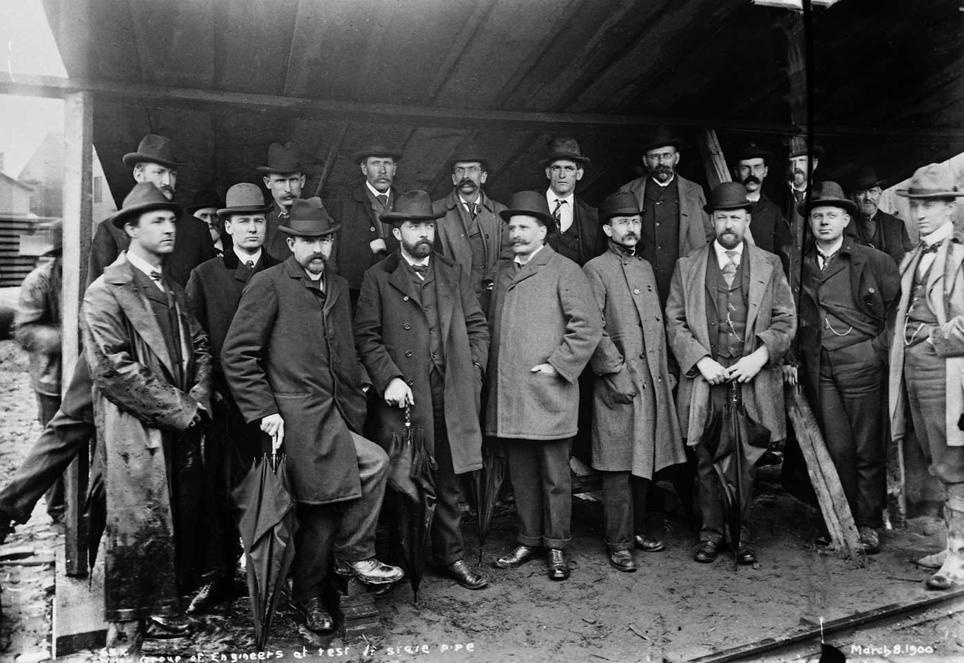
Less than two months before the City Council’s May 1, 1900 inspection, an unidentified group of Seattle-based (we assume) engineers were invited to inspect the project as well. Yes R.H. Thomson is among them, and can you find him? The date is March 8, 1900.
The following photo and its repeat directly below are one of the many comparisons Jean and I make in our book “Washington Then and Now.” It is described in greater detail on its own webpage and also appears in the “store” we have buttoned on this blog
THEN: The Tolt River pre-dam, mid-50s NOW: The Tolt in 2006
CLICK to enlarge this and you will see by the clock on the porch that it is 1:35 pm. Here is Violet, Frank Shaw's friend, we assume, walking towards Frank and his Hasselblad from her home with a small ribbon decorated gift in her right hand. It will be exactly 30 years ago at the instant I gently push the "insert-publish" buttons for this little story sending it onto the blog. It is countdown now with a minute to go! My this is exciting - for me!
We follow Shaw’s Christmas afternoon snap of Violet with three more scenes he photographed in December 1979. None of them are descernibly cheery.
Shaw names the photographer on the right, "Mike." He does not name those posing for a "metro photoshoot." The date is Dec. 12, 1979.Frank Shaw looks over the fleet of fresh Japanese autos and south through Smith Cove to the city skyline on Dec. 22, 1979.Something has drawn Shaw to the "Fort Lawton covered motor pool" on Dec. 28, 1979.
One more Frank Shaw contribution, and this from 1976.
From the balcony at the Food Circus/Centerhouse, Frank Shaw looks over an oversized winter model train layout to the old Century 21 "Bubbleator" dressed as a snowman. Shaw recorded this two days after Christmas, 1976, when Seattle Center was resting. Two two-and-a-quarter negatives, side-by-side, and both recorded by Frank Shaw on Dec. 4, 1976. This is some perhaps short-lived Pioneer Square promotion of a "Father Christmas." If readers look at the comment by Jana to this insertion they will find a link to photos of her's from 1978. Included among them is a record of the "Father Christmas" booth at Pioneer Square in 1978, althought not, as far as I could determine, of the Father himself. Apparently this "Father Christmas" did not endure as a proliferation - after Santa - of gift-giving men with long hair. His ringlets look both attached and Scandi. And perhaps he is not giving gifts but taking ornaments from the children, which he then attaches to the P-Square tree.
Below the following seven illustratons with shortish captions, is a “reprint” of this weeks now-then from Pacific Magazine, and a fine description by Jean of his visit with 90-year-old (and looking 77) Mercedes wonder-salesman Phil Smart on Capitol Hill’s Auto Row.
It was, as the above advert understands, one’s “itch to grasp a steering wheel” that turned Capitol Hill in to Seattle’s Auto row, and primarily on Pike Street and Broadway Avenue.
Still in 1909, the year of the primary now-then scene printed a few photos below, the best and cheapest way to grasp a steering wheel was to take your turn for a photo opportunity at the Alaska Yukon Pacific Expo that year.
Here is more evidence of auto-heat on Pike Street, the Mills Motor’s used car lot between Summit and Crawford Pl. Street car tracks are still showing on Pike and that’s the Covenant Church on the left.
A glimpse into early 20th-Century Capitol Hill. Here a Frasch photo titled Lincoln Park – but known better as Broadway Playfield – looks south towards Second Hill. Construction of the Providence Hospital tower is dimly evident on the horizon near the center. The new hospital was officially opened in 1912.
The joys of dependable motoring were for many never more reliable than with the Dodge Dart. Dart was low priced and it kept on running. This promotional game was staged for long-time Seattle commercial photographer Roger Dudley. Thanks to Danny Eskenazi for sharing it.
Not on Capitol Hill – or even about cars – but in the state’s capitol. Here is one view of the rotunda-dome repeated 16 times – the Joys of Photoshop. The photograph from which this montage was constructed was recorded during our – Jean and my – visit to Olympia during Christmas season 2007 to help promote our book of state repeats, “Washington Then and Now.” The picture included directly below, and the last of the seven that prelude this week’s now-and-then on Pike Street’s Auto Row, is a 1926 construction scene of that same rotunda. This view and its repeat are included in the book just noted, which you can see in great detail on our webpage that is pretty much devoted to it: washingtonthenandnow.
Here are a couple of Washington coast photos from the collection of history buff Ron Edge. Question is, where were they taken? The first one dated 1905 has elements of the area north of Ruby Beach but that’s just a guess.
Attempting to repeat a photo for a recent ‘Seattle Now and Then’, I found myself atop the Hyatt, looking west along Pine. A bit of a gloomy day, but an interesting view, nonetheless. Here’s a slightly distorted stitch of a few pix.
Yesterday, I made a few stops around town picking up Now and Then shots for Paul’s column. Those below are extras.
First, I stopped at the 41st and Aurora pedestrian overpass and met historian/preservationist Heather McAuliffe and her daughter’s grade school class and teachers from BF Day for a repeat of a 1936 photo. The original was taken below the overpass looking up.
Then I headed downtown to meet Ron Edge, a photo collector and history sleuth, who’s been helping Paul unravel mysteries. We were trying to repeat a pic of an old tin shop at the corner of what is now 1st and Yesler. Here’s Ron, braving traffic:
Later that afternoon, I met baseball historian Dave Eskenazi and we climbed up on top of a vast rooftop (a windowless storage building for King County Elections) looking for signs of Dugdale Park, an ancient baseball field. This eerie white expanse, which covers the footprint of the old park, is just around the corner from Washington Hall at 14th and Fir.
As always, click on the pix to see them full size.
Attached here is the cover to the second issue – from April 1969 – of the Northwest Passage, the splendid and long-lived (although no longer) tabloid that was Bellingham’s contribution to the “underground press” of the late 1960s and after. Many of those connected at one time or another with the paper – and there were through its life many hundreds – meet irregularly as members of the Old Fools Society or Old Fools Salon or Old Fools Forces or some other Old Fools. Now this far-flung membership is using the web to ween about a 40th anniversary of the NWP founding and, perhaps, to “repeat” the historical group pose that appears below. This is an extended call for help in naming those captured here in the Spring of 1969 on some enchanted old porch in Bellingham or near it. (Mouse it to enlarge it.)