THEN: In Lawton Gowey’s 1961 pairing, the Smith Tower (1914) was the tallest building in Seattle, and the Pioneer Square landmark Seattle Hotel (1890) had lost most of its top floor. (by Lawton Gowey)NOW: The mockingly named “Sinking Ship Garage” replaced the ornate brick Seattle Hotel with a concrete garage capped by a railing of bent pipes that resemble a row of basket handles.
Lawton Gowey was a regular visitor to the demolition scene of the Seattle Hotel. His collection of Kodachrome slides records nearly the entire process of the destruction of the 1890 landmark. Gowey dated this slide June 8, 1961. The demolition work began with the interior on the third of April, and here, two months later, most of the top floor is gone.
Rubble dropped from the roof of the Seattle Hotel during the 1949 earthquake. (Courtesy, Seattle Post-Intelligencer)
The removal of the ornate cornice at the top of the five and one-half story landmark got an early start with the city’s 1949 earthquake. For safety, and probably for economy too, much of it was removed following the quake. Still, the hotel stayed opened until the spring of 1960, when its closure was announced. It was widely assumed that it would soon be razed – not renovated. The same was expected for its then still on the skids Pioneer Square, the city’s most historic neighborhood.
When new in 1890 the future Occidental and finally Seattle Hotel was named the Collins Building for its owner. Here, and in the four photos below, James Street is to the left and Mill Street (Yesler Way) to the right.
Lawton Gowey’s record of the garage and a few of its neighbors on March 20, 1974.
Citizen response, however, was surprising. In an attempt to save the hotel, a local cadre of preservationists quickly formed. Although that battle was lost, the enthusiasts for local heritage won the war by saving the neighborhood. The city’s new Department of Community Development, the DCD, formed the Pioneer Square Historic District in 1970.
The Logan Building at the northeast corner of Fifth Avenue and Union Street. Seattle’s first Glass Curtain modern.A model for a National Bank of Commerce designed by Mandeville and Berge, architects for the “Sinking Ship Garage.” Pulled from the Seattle Times for Feb. 26, 1967.
By this time the four-floor parking lot that was built on the hotel’s flatiron footprint was commonly called the “Sinking Ship Garage.” It is still one of our best local jokes. The garage’s architect-engineers, Gilbert Mandeville and Gudmund Berge, were fresh off their 1959 success as local consultants for the Logan Building at Fifth Avenue and Union Street, the city’s first glass curtain box. Here, in Pioneer Square, they added what they and its owners considered a compliment to the historic neighborhood: a basket-handle shaped railing made of pipe, a kind of undulating cornice, that ran along the top of the concrete garage.
The garage’s basket handles aligned with those on the Interurban Building at the southeast corner of Yesler Way and Occidental Avenue.Two more sympathies for the bent pipes on top of the Sinking Ship: the windows in the Mutual Life Building, left-center, and the Pioneer Building, upper -right. Courtesy Lawton Gowey, April 21, 1976
Lawton Gowey loved the Smith Tower. His juxtaposition of the well-wrought tower, the injured hotel, and the wrecker’s crane is at once elegant and ambivalent.
WEB EXTRAS
Anything to add, lads? Golly Jean, yes. Ron Edge has put up two links to past features. Both are rich with references to this triangle. Following that are few more relevant clips cut from past Pacifics.
=====
Appeared first in Pacific for Sept. 26, 1982 [Click TWICE to ENLARGE]===
Appeared in Pacific first on November 20, 1983. [Click TWICE to enlarge]=====
First appeared in Pacific on July 13, 1986.
=====
Appeared first as a Historylink demonstration in Pacific on July 19, 1998. I will add that the founding of Historylink still feels novel, and the notion or evidence again that we first started all that in the late 1990s has an uncanny edge for me. And nostalgic. [Click twice to enlarge]=====
First appeared in Pacific, Oct. 31, 1999
====
First appeared in Pacific, June 6, 2004
=====
Circa 1984, looking west from near Second Ave. along the south facade of the Pioneer Square Garage, AKA the “Sinking Ship.” That’s all folks!
THEN: Faced, in part, with brick veneer and stucco, and opened in 191l, the Comet Apartments at 170 11th Avenue have made it nicely through their first century. (Courtesy, Lawton Gowey)NOW: Missing only a few architectural bands that once wrapped its sides, the now Star Apartments have gained a landscape that caresses the daylight basement windows.
By the estimable authority of Diana James, the Comet Apartments, this Sunday’s subject at the First Hill corner of Spruce Street and 11th Avenue, is a solid example of a building form she calls “Seattle-Centric.” In “Shared Walls,” her book history of our city’s apartment houses, James explains, “Driving or walking through Seattle neighborhoods that have concentrations of apartment buildings, one is struck by the repetition of a particular form, best described as rectangular or square in shape and featuring at least one bay on either side of a centrally located and recessed opening at each floor above the entrance. Variations on this theme exist in every Seattle neighborhood.”
The Comet Apartments are found above the center of this detail pulled – again – from the 1912 Baist Map. (Courtesy, again, Ron Edge) CLICK TO ENLARGE – PLEASE.
By another authority, King County tax records, organized in the late 1930s by the depression-era Works Progress Administration (WPA), the Comet (its original name) was built in 1910 with twenty-eight apartments. Seven of these were fit with four rooms, and the rest with three. West and Wheeler, the Comet’s real estate agent, described it in The Seattle Times “Apt Unclassified” listings for March 4, 1912, as “an unusually attractive building.” We still agree.
The Comet/Star depression-era tax card. (Courtesy, Washington State Archive, Bellevue Community College Branch)
The Comet’s 1912 classified packed a terse list of its qualities, including “large light rooms,” “very reasonable rates (twenty to thirty dollars),” and the unnamed but “usually up-to-date apt. house conveniences.” The Comet was also in a “paved district” that was conveniently in “walking distance.” Surely these First Hill apartments were within a reasonable stroll of nearly every necessity. Pacific Grade School was three blocks north on 11th at Jefferson Street, and professional baseball, a mere two blocks away at the Seattle Athletic Field. (see below) If walking was not wanted, the Comet was surrounded by common carriers, including the trollies on Broadway and 12th Avenues and the cable cars on James Street and Yesler Way. For the mostly downhill three-quarters of a mile trip to Pioneer Square, a brisk step might get there almost as quickly as a ride on the famously rattling cable cars.
Near it last day, a Yesler Way Cable Car approaches Seventh Avenue on Yesler Way, now the eastern border of the 1-5 Freeway. The photograph was taken by a trolley and cable enthusiast in 1940. (Courtesy, Lawton Gowey)
On November 21, 1938, the Comet – by then the Star, the name that stuck – was enrolled on the year’s list of victims of the nearly sixty apartments and homes visited in the night by the then best-known – as yet unnamed and uncaught – person in Seattle: a firebug. Of the four apartments – three on First Hill – ignited “by a pyromaniac” that early morning, the city’s fire Chief William Fitzgerald described the Star’s as “the most successful.” It was set in a dumb-waiter shaft, did $2,000 damage and “routed 100 persons from their beds at 3:30 in the morning.” Addressing the city – especially the residents of First Hill – the fire chief asked for “intelligent assistance” rather than “mass hysteria.” The fire chief may have also had Police Chief William Sears in mind, who earlier had let it out that he “feared a catastrophe if the firebug is not apprehended.”
(The fire bugs – two of them during the Great Depression – left an impressive paper trail in the local press. An industrious historian might consider telling this story while using the very handy and almost omnipresent tax photos of the victims, of which very few were burned to the ground.)
WEB EXTRAS
Anything to add, Paul? Rob? Diana? Sure Jean. Rob has pulled a number of past blog features that “approach” this week’s subject on the southeast corner of First Hill. Again, because these links are often packed with other features they may also approach other corners or even hills. At the bottom we will add the Pacific Mag. clipping with the story about Dugdale Park (the first one) aka the Yesler Athletic Field at 12th and Yesler. These feature local baseball historian Dan Eskenazi and are used with his courtesy and with the repeat your Nikon Jean. Turning now to you dear reader, please explore these links. The first one features the pie-shaped Sprague Hotel in the original flat-iron block nestled between Spruce and Yesler, and then reformed as part of Yesler Terrace. You may wish to also key-word “Yesler Terrace” in the search box above. As you know Jean, Diana does not have a key to this inner sanctum, only to hearts and minds, your’s and mine.,
=====
Yesler Athletic Field, 12th and Yesler. (Courtesy, David Eskenazi)
David Eskenazi on the roof.
======
MEANWHILE AND NEARBY – MORE BILLBOARD PORTRAITS FROM THE FOSTER-KLEISER COLLECTION
Looking south on 12th Avenue to the corner of Alder Street, on March 14, 1940.Twelfth Avenue looking south towards Main Street, Nov. 31, 1936Twelfth Ave. looking north thru Fir Street corner, 1939.Jackson Street looking west towards 12th Avenue – if I have “read” this correctly.
THEN: In this 1887 look up Columbia Street from the waterfront is the bell tower of the fire station, tucked into the hill on the right. It would soon fail to halt the city’s Great Fire of June 6, 1889. The station and everything between it and Elliott Bay were reduced to ashes, smoldering bricks and offshore pilings shortened like cigars. (courtesy, Kurt Jackson)NOW: After the Great Fire, the waterfront was extended farther into Elliott Bay, first above pilings and eventually on fill packed behind a seawall.
Charles Morford, who migrated with his parents from Iowa in the spring of 1887, was 20 years old when he recorded this unique Seattle cityscape a few months later. Morford’s subject looks east up Columbia Street from the Seattle waterfront as far as the Coppin water works at Ninth Avenue. The four-story tower’s open First Hill observatory stood 300 feet above Morford’s prospect. The well below it supplied most of the neighborhood, and its bored-log pipes reached down the hill at least as far as James Colman’s mansion. Its Italianate tower also breaks the horizon, here at the southeast corner of Columbia and Fourth Avenue.
We may be confident that the Seattle Lake Shore and Eastern Railway baggage/express car, at the bottom, is new. By historian Thomas Prosch’s reckoning in his “Chronological History of Seattle” (1901), the car was delivered in September 1887. This timing is in fine coincidence with the construction scaffolding attached to the Toklas and Singerman Department Store, on the right. The rough lumber is soon to come down. The store was completed on Sept. 28, although the formal opening waited until Nov. 9.
A few days after the opening of the department store, which was then the highest building in Seattle, the railway was also celebrating. On Thanksgiving Day it gave 108 locals a free round-trip ride to its then new end-of-the-line in Bothell.
Included among Morford’s surviving glass-plate negatives are several more of the Seattle Lake Shore and Eastern. At what point Morford also became an employee of this railway is unclear. But in the fall of 1887 he would not yet have known that most of his gainful employment here would be with the retail business behind the scaffolding. Morford became a clerk, first, with MacDougal Southwick, the partnership that bought out Toklas and Singerman in 1892. Morford soon became the store’s general manager and one of its stockholders.
WEB EXTRAS
Anything to add, Paul? The solo feature that Ron Edge pulled and placed directly below includes several subjects that relate to this week’s feature. The “lead” feature, printed here below, shows the Toklas and Singerman department store completed, and so without the scaffolding that hides its north facade in the prime feature at the top. The reader may wish to search the several other features that can be found by clicking on the link. Please give special attention to one about the 1884 snow as seen looking east up the waterfront from close to the same prospect that Morford used for his shot at the top. Much has changed in these three short years that felt both the lingering effects of the 1883 recession and the general excitement of the completion of the Norther Pacific to the northwest, also in 1883. Seattle’s boom years were at the front door, which is to say, both on the waterfront and heading this way from Chicago, Portland and, resentfully from Tacoma too, across the tideflats south of King Street on rails.
======
FOLLOWS NOW (soon) A FEW MORE PHOTOS OF THE WATERFRONT AT or NEAR COLUMBIA STREET
A Peterson and Bros. photograph taken from the end of a dog-legged Yesler Wharf and looking up Columbia Street on the right in 1878. Note the tower for the “White Church” on the right, the Methodist Episcopalian congregation that was the first in Seattle. It sits there at the second lot south of Columbia on the east side of Second Avenue. Also note that for the most part First Hill has been denuded of the virgin forest that still covered this horizon as late as 1872.Seattle’s first church, the “White Church,” and the Methodist Episcopalian parsonage to this side of it on the southeast corner of Second Avenue and Columbia in the 1870s.The waterfront ca. 1885 with an early Colman Dock on the left, Columbia Street on the right, and a short feature essay below (after I search and find it tomorrow), and the contemporary repeat photographed officially – only – in the anxious glow of 9/11 by Shawn Devine, an employee of the Washington State Ferries.
COLMAN DOCK AND THE WATERFRONT ca. 1886 (text to come)
Seattle’s Great Fire of June 6, 1889 reaches the foot of Columbia and the depot for the Seattle Lake Shore and Eastern Railway, and will soon consume it and everything south of it to the tideflats.
Columbia Street looking west from the waterfront in the first year following the 1889 fire. The new Seattle Lake Shore and Eastern depot is on the right, and the rear facade of the new Toklas and Singerman Department Sore rises five stories behind it. Photo taken by the Northern Pacific Railroad’s official photographer, F. J. Haynes. (Courtesy, Tacoma Public Library and Murray Morgan)Horace Sykes’ (or possibly Robert Bradley’s) look east up Columbia Street from the top of the new – and as yet not used for traffic – Alaskan Way Viaduct aka Freeway in 1953.
THEN: One of a few photographs recording from different prospects the Fremont trolley car barn on Dec.11, 1936. North 35th Street, on the right, was originally named Blewett for Edward and Carrie Blewett. In 1888 the couple, fresh from Fremont, Nebraska, first named and promoted Fremont as a Seattle neighborhood. That year Fremont also got its lumber mill. (Courtesy, Lawton Gowey)NOW: For his “repeat” Jean stepped into the street to reveal, above the Fremont Fair booths at the scene’s center, the northeast corner of the surviving Fremont Car Barn. Since 2006, it has been a factory for Theo Chocolate, where the confectioner prepares “organic and fair-trade” sweets.
The negative for this scene of industrial clutter is marked “Fremont Barn – N.E. Corner, Dec. 11, 1936.” “Barn” is short for “trolley car barn,” that long and well-windowed brick structure that fills the horizon from N. 35th Street on the right to the interrupting house on the left. It was photographed without credit, although most likely by an employee of Seattle’s municipal railways. From mid-block, the prospect looks west through the long block on Fremont’s 35th Street between Evanston and Phinney Avenues.
The featured photo was one of a few taken the December day centering on “barn.” We will follow here with three more.
The car barn across the canal with B.F.Day primary school on the left horizon. (Courtesy, Lawton Gowey)
When it was completed in 1905, the ornate barn, along with the B.F. Day School nearby on Fremont Avenue, was one of the few brick structures in this mill town neighborhood. Inside the barn there were accommodations for the trainmen and also three bays for trolley car repairs. Most of the homes built in the Fremont neighborhood, after 1888 when the lumber mill opened, were modest residences for workers. In 1936 there were sixteen houses on this long block. Now, it seems, only six have endured.
Trainmen posing in the open bays.
As can be seen in the primary feature photo at the top, between the home and the barn there was room for both a yard of well-packed trollies, and closer to the photographer, an uncovered storage for stacks of what appear to me to be trolley-car-wide blocks of formed concrete. (Perhaps a reader will know and share their use.) With the help of a 1936 aerial photograph, we can see both the stacks of concrete and count a dozen rows of trollies resting on their tracks – spurs off N. 34th Street – in the yard between the barn and the stacks. The twelve tracks were all five cars long, and so this parking lot could accommodate a maximum of 60 trolley cars tightly fit like these.
A detail from the 1936 aerial coverage of Seattle. The trolley barn is far left at the corner of Phinney Ave. N. and N. 34th Street (at the bottom of the detail) with Evanston Ave. N., far right. The house, with its northwest corner showing in the feature photograph, is mid-block on the south side of N. 35th Street between Evanston and Phinney. Between it and the rows of parked trollies, the scattering of white forms – the same as those at the top – appear. (Courtesy, Ron Edge)A similar detail for comparison, this one of the 1929 aerial survey. (Courtesy, Seattle Engineering Dept. and Ron Edge)Also for comparison, the featured photograph from 1936 set beside a detail from the 1912 Baist Real Estate Map. The trolley is aglow in red.
In 1936 the municipal system ran 410 often-dilapidated electric trolleys over its worn 224 miles of tracks. Leslie Blanchard, Seattle’s trolley historian, described 1936 as “the beginning of one of the most violent and spectacular political free-for-alls ever witnessed in the city of Seattle.” The fight was over whether to keep to the tracks and fix-up the system or convert it entirely to rubber, with busses and trackless trollies. Of course, the latter won, and between 1940 and 1942 the tracks were pulled up and the trollies scrapped. The Fremont Barn was then purchased by the army for wartime storage.
The parks cars were hosed from towers.
Friday the eleventh of December 1936 is well remembered on both the sentimental and scandalous sides of world history. While the photographer for this Fremont scene was, perhaps, having breakfast, His Royal Highness, the Duke of Windsor, explained to the British Empire by radio from Windsor Castle, that the burden of being king was a “heavy responsibility too great to bear without the help and support of the woman I love.” The trouble, of course, was that “that American woman,” Mrs. Wallace Simpson, was already married.
WEB EXTRAS
Anything to add, Paul?
JEAN, as our readers may suspect, we often return to Fremont. Still this week for Ron “EDGE-LINKS” we will restrain ourselves and include only a half-dozen or so. In this conspiracy, for reasons we will make clear below, we have an eye out for the blog you did years ago recording (with whatever Nikon you had at the time) one of the Fremont Solstice Day parades. We will not fail in this. In our several years of producing dorpatsherrardlomont it has been easily the most viewed – or goggled – post we have put up. This shaking of hits has more to do with hirsute than heritage Following the links we will chain a few Fremont strays to this barn. First, the reader is encourage to click on the seven pictured links below. They all include Fremont features and more. Of the seven we have put at the bottom the recent feature on they day the Fremont Dam broke in 1914.
======
The Fremont Car Barn on Sept. 23, 1919. Over the bays the private company name has been replaced with the public name. (Courtesy, Seattle Municipal Archive)Lawton Gowey’s May 27, 1968 recording of the barn when it was still used for storage.The barn during a recent Fremont Fair. I recorded this but have lost the year – for now.The text the hung from the oldest of the three photos above with its printing in The Seattle Times Pacific Magazine for January 31, 1988.
THEN: Local candy-maker A.W. Piper was celebrated here for his crème cakes and wedding cakes and also his cartoons. This sketch is of the 1882 lynching from the Maple trees beside Henry and Sara Yesler’s home on James Street. Piper’s bakery was nearby (Courtesy, MOHAI)NOW: Jean took his repeats looking across James Street from both the open roof of the “Sinking Ship Garage” and from one of its screen-protected windows. Although somewhat high, we chose the former
If you are inclined to write a history of Seattle then you must include the three bodies hanging here between two of Henry and Sara Yesler’s maples on the early afternoon of January 18, 1882. The trees were planted in 1859; and they appear first as saplings in the earliest extant photo of Seattle, which was recorded that year. By 1882, the shade trees were stout enough to lynch James Sullivan and William Howard from a stanchion prepared for them between two of the Maples.
Yesler’s home at the center with James Street to the right of it, typically dated 1860. The forest at the top encroaches on 5th Avenue.A year and a half after the lynching Henry and Sara Yesler pose in front of their home at the northeast corner of Front (First Ave.) and James Street on July 4, 1883. The hanging trees are on the right. [Courtesy;, Northwest Collection, U.W. Libraries.)Henry liked to whittle.
As ordered by the judge, the accused couple expected to be returned to jail when their preliminary trail in Yesler’s Hall at First Ave. and Cherry Street was completed. Instead the vigilantes in attendance covered Territorial Supreme Court Judge Roger Sherman Green with a hood, bound the guards, and dragged like the devil the doomed couple up the alley to James Street. There the leafless maples suddenly exposed their terrifying landscape to Sullivan and Howard. Soon after being violently pulled from court – in a few pounding heart beats – these two prime suspects of the daylight killing the day before of a young clerk named George B. Reynolds, were lifeless and their swinging corpses played with.
A map of Seattle in 1882 idealized by it’s real estate. (CLICK to ENLARGE)Watklin’s 1882 panorama of Seattle from Beacon Hill, as it is framed and explained on a page of Prosch’s picture album of pioneer Seattle preserved in the University of Washington’s Northwest Collection. Below is a detail pulled from this pan, which includes a fat red arrow indicating the location of the 1882 lynching.
During his 1882 visit to Seattle, Watkins also used the King Street Coal Wharf to record a panorama of what was by then the largest city in Washington Territory. In this one of the panels from his pan, the location of lynching is below the top of the pile driver stationed right-of-center. The entire pan is printed next.Most – perhaps all – of Watkin’s 1882 pan of Seattle and its waterfront, taken from the King Street Coal Wharf. [CLICK TO ENLARGE]Watkins was visiting from California. Peterson, the photographer of this look up the waterfront, also from the King Street coal wharf, had a studio in Seattle. Most of its was portrait work, but his art for cityscape was hereabouts the best of the time. This is tentatively dated ca. 1882. The wharf building commotion in the Watkin’s pan has as yet not begun. (Click to ENLARGE)
In a few minutes more, the by now hungry mob pulled from jail a third suspect, a “loafer” named Benjamin Paynes, who was accused of shooting a popular policeman named David Sires weeks before. For a while the hanging bodies of the three were raised and lowered over and over and in time to the mob’s chanting, “Heave Ho! Heave Ho!” Children who had climbed the trees to cut pieces of rope from the cooling bodies tied them to their suspenders or, for the girls, to the pigtails of their braided hair. It was, we are told, for “show and tell” in school.
In July, 1886 the Yesler’s moved up James Street to their mansion facing Third Avenue. It was sided at the corner with Jefferson by an orchard large enough for lots of apple sauce and branches for crimes and punishments, although none were used so. Sara died in 1887 and Henry in 1892.
Although there were several photographers in town, none of them took the opportunity to record – or expose – a lynching. Who would want such a photograph? Judging from the local popularity of these killings of accused killers, probably plenty. A few weeks following the stringing, Henry Yesler was quoted in Harpers Weekly, “That was the first fruit them trees ever bore, but it was the finest.” It was Seattle’s first really bad nation-wide publicity.
Right to left, Yesler, Gatzert and Maddocks, made a Christmas tradition out of carrying together greeting cards to their friends in town, and probably getting their fill of seasonal snaps in return. Below is a portrait of a younger Henry – a Henry who looks fit for wrestling with Puget Sound’s first steam saw mill.
In Andrew William Piper’s cartoon of the event, the easily identified Henry stands in the foreground busy with his favorite pastime: whittling wood. The cartoonist Piper was a popular confectioner who loved dancing and singing with his wife and eleven children. He was also a practical joker and the first socialist elected to the Seattle City Council. We don’t know if Piper also joined the local chorus of acclaim for the hangings. Judge Green more than objected. Once free of his hood, he rushed to the lynching and tried to cut the ropes, but failed.
On the far right of his cartoon, the cartoonist-confectionaire Piper has included the sign of the Chronicle, a newspaper located in the alley behind the Yesler back yard. It was up this alley that the victims were rushed to their lynching. Printed next is a transcript from an 1883 issue of the Chronicle, which describes a resplendent new saloon in the basement of the new Yesler-Leary Building at the northwest corner of Front (First Ave.) and Yesler Way and so also at the foot of James Street.
An excerpt from the August 23, 1883 issue of the Chronicle.The Yesler-Leary building at the northwest corner of Yesler and Front. Like the rest of the neighborhood, including the Yesler’s hanging trees, it was destroyed during the “Great Fire” of 1889.Twenty-six years later, the lynching block on James Street, between First and Second Avenues in 1908. The photo was recorded from the Collins Building on the southeast corner of Second Ave. and James Street. The Collins survives and well too. On the left is the northeast corner of the Seattle Hotel. It was destroyed in the early 1960s for the “Sinking Ship Garage.” The side below the Pioneer Building, right-of-center, where they lynching was done in 1882, is here crowded with locals and tourists in town for the 1908 visit of the Great White Fleet. A few of the dreadnoughts can be seen in Elliott Bay.
WEB EXTRAS
Anything to add, Paul? Yes Jean, and most of it, again, links to past features related to the place and/or the subject. Most of extras – if one takes the opportunity to click and read – will be the several links that Ron Edge will be soon putting up directly below this exposition. Then, after the links, we will probably continue on with a few more features – if we can find them tomorrow (Saturday) night when we get to them. We should add that we do not encourage lynching of any sort, or for that matter capital punishment. It is all cruel, pathetic and even useless. Yes – or No! – we do not agree with the wood whittler Henry Yeslers. We have imprisoned within quote marks our title “finest fruit” borrowed from him.
======
NIGHTY-BEARS SKUFFLE
Again, we have reached that nighty-bears (copyright) moment before we are finished, this time with lynching-related extras. Until we return in the morning – or sometime tomorrow – to continue dressing our figures, here is a James Street related skirmish I photographed in the early 1980s. This, we hope, will momentarily satisfy the urges for sensational news we may have nurtured. The 1882 lynchings were a few feet behind me, a century earlier.
THEN: In the late afternoon and evening of Seattle’s Great Fire day, June 6, 1889, Leigh and Lizzie Hunt’s home at the northwest corner of Fourth Avenue and Columbia Street was, within a few hours, arranged to accommodate the family’s business, The Seattle Post-Intelligencer newspaper. (Courtesy Lawton Gowey)NOW: The parking garage, at what was the Hunt’s corner, was built in 1923 and survives as an unheated shelter for a few dozen cars. This Central Business District corner is valued by the taxman at more than four-and-one-half thousand times the value of this reinforced concrete “improvement.” The Rainier Club, its neighbor across Fourth Avenue, can be glimpsed on the right. The figure making his way down Columbia is production tech/designer/inventor/wunderkind David Verkade.
One of the five men posing beside The Seattle Post-Intelligencer’s office may well be Leigh Hunt, who with his wife Lizzie was the owner of both the newspaper and the house. The latter became the P-I’s temporary quarters after the city’s Great Fire of June 6, 1889, destroyed the paper’s office and plant at the corner of Mill Street (Yesler Way) and Post Avenue (aka Post Alley). Before the sign was even in place, the P-I began publishing, here at the northwest corner of Columbia Street and Fourth Avenue.
The worst part of the rip in this clip reads, “Two little job presses worked by foot power.” The clip is also a LINK that will take you to the full two-page edition of Hunt’s Post-Intelligencer, the first following the June 6 “Great Fire,” and the one composed in part by foot power. [CLICK to open.]
In 1886, at age 33, Hunt had given up his presidency of the Agricultural College of Iowa at Ames for the exhilarating, if risky, enterprise of running his own newspaper, The Seattle Post-Intelligencer. The paper had begun in 1873 as the Seattle Gazette, a one-sheet weekly and Seattle’s first newspaper, and carried on with a variety of names and owners. Hunt’s stay lasted little more than six years, ended in bankruptcy triggered by the nation-wide economic panic of 1893.”
Although deep in debt, Hunt’s powers of persuasion soon moved the Great Northern Railroad to help pay his way to Korea, where he founded the Oriental Consolidated Mines and quickly made millions extracting gold. After he returned to Seattle, Hunt opened an office announcing that he was prepared to “meet all his debtors and pay in full.”
Leigh Hunt began the 20th century with a safari to Egypt’s upper Nile “for his health,” but “like the wide-awake American everywhere,” soon developed his trip into a scheme to get richer by growing cotton in the Sudan with British cooperation and the labor of American Negroes. Hunt’s characterization of his plan to give the colonizing blacks opportunities to acquire homes and skills got him no help from the black educator Booker T. Washington, who while in Paris, announced that “I am here merely to study the best known French manual training schools and have no intention of proceeding to Cairo to meet Leigh Hunt.”
In the summer of 1932 the 75-year-old Hunt’s planned visit to Seattle was cancelled when he fell from a twenty-foot ladder while examining a mine near Las Vegas, Nevada, his last hometown. His Seattle Times obituary of October 5, 1933, made claims on him. “It was here that Mr. Hunt entered his business career, which eventually took him all over the world, and it was here that he left the imprint of his genius for organization, promotion and development.” Hunt’s Times obit. is attached immediately below in a context of a few other stories that day.
[CLICK to ENLARGE]
WEB EXTRAS
Anything to add, Paul?
The best addition is from Ron Edge. It is the clipping from the P-I’s first issue following the fire. It is an extra you have already encountered – we have embedded it in the story above. We will also include a link from 2012, the feature about the Burnett Home across Fourth Avenue from Hunts, at the northeast corner of 4th and Columbia. Include within its link are other features from the neighborhood, including one on the Meydenbauer Home, which was also on Columbia and near by at its northeast corner with Third Avenue.
THEN: Looking west on Madison Street from Seventh Avenue circa 1909. (Courtesy, Washington State Museum, Tacoma)NOW: Aside from the Dover Apartments at 901 6th Avenue, that can be found above the trunk of the red sedan in the foreground, the skyline from the Seattle Tower on the left, to The Renaissance on the right, is new with high-rises that reach far above the frame of Jean’s repeat.
The Lombardy Poplars that once lined much of Madison Street from Fourth Avenue to Broadway made First Hill’s favorite arterial “the most attractive place in town.” That is on the pioneer authority of Sophie Frye Bass, found in her delightful book of reminiscences, “Pig-Tail Days in Old Seattle.” Here the photographer A. Curtis looks west-southwest, through the intersection of Madison Street and Seventh Avenue to Central School, on the left, and the Knickerbocker Hotel, on the right. Central School opened in 1889
Looking southwest from the same intersection of 7th Avenue and Madison Street with younger winter-leafless poplars.
with Seattle’s first high school installed on its third floor. Sixty years later the school’s landmark towers were prudently removed after Seattle’s 1949 earthquake.
This ordinarily busy intersection is oddly vacant in the feature subject, crossed by neither motorcar nor team. However, the pavement bricks – no doubt slippery – are layered with clues. A combined mess of auto oil, horse droppings – and what else? – marks them.
Above and below, looking east on Madison Street from Sixth Avenue. Rising high at the center, the Knickerbocher is nearly new in the ca. 1909 photograph above by Arthur Churchill Warner. The poplars are long since stripped away in Lawton Gowey’s recording from June 19, 1961. Knowing Lawton, I’d say that he was capturing a last look thru the block before it was razed for the Seattle Freeway.
A Seattle Times clipping from Jan 5, 1963 featuring a look north from the Knickerbocher roof to the advancing work of the freeway. CLICK TO ENLARGEThe Smith Tower’s prospect into the neighborhood on June 21, 1961. Near the subject’s center only the long auxiliary structure along Marion Street survives. From there to the left and beyond parked cars covering the footprint of the destroyed school, the Knickerbocker still rises. This is another Kodachrome slide by Lawton Gowey.From Madison Street, Frank Shaw’s 1963 look thru the rubble that was contributed by the hotels, including the Knickerbocker, along the north side of Madison Street. Lawton again.The third of four First Presbyterian sanctuaries, and the first one built on the east side of Seventh Avenue, between Madison and Spring streets. Lawton Gowey recorded this on Feb. 6, 1967, the year and winter season that the Seattle Freeway was dedicated. Gleaming west facade of the Christian Scientists (now Town Hall) at the southwest corner of 8th and Seneca, appears far left. Behind it is the Exeter House, at the northwest corner.
The Knickerbocker was built in time for Seattle’s first world’s fair, the 1909 Alaska-Yukon-Pacific-Exposition, held on the UW campus. Advertised as “strictly modern,” the hotel’s ninety rooms were for the most part taken as apartments. In 1911 weekly rents were three dollars and up. Included among its more sensationally newsworthy residents in the half-century before the hotel was razed for the Seattle Freeway, were a forger, a three-and-one-half year old boy deserted by his parents, and a Knickerbocker manager who – it seems – murdered his wife. And the hotel’s visitors featured more than one robber.
A dated construction scene on Presbyterian’s over-sized sanctuary, looking here at the front door facing the corner of 7th Ave. and Spring Street. (Courtesy Michael Maslan)Nearly new and presently four Corinthian columns to the intersection of Seventh Avenue and Spring Street.Lawton Gowey’s look east on Spring Street to First Presbyterian on April 19, 1966, and without its two original domes, one of which was home to the church’s radio station, another pulpit for any preacher, but most importantly its builder, Mark Matthews. Lawton was also a Presbyterian and for decades the organist at his church on Queen Anne Hill. He died of a heart attack in 1983 while preparing for another Sunday service.
On the brighter side, in a letter to the Times editor, Knickerbocker resident Carol Cornish expressed her thanks that living at 616 Madison put her “close-in” to downtown opera and concerts. In her letter from Oct. 28 1940, Ms. Cornish also included a culture-conscious complaint about concert audience behavior. “I hate to be stuffy, but the shallow, careless frivolities of the so-called smart set often fill us unaspiring social plebeians with a definite distaste.” During the Great Depression of the 1930s, the Times, awarded the Knickerbocker Hotel by including it in its “Business and Professional Ledger.” After the Second World War some hotel rooms were outfitted with dark rooms for rent to amateur photographers. And through much of the 1950s, the Knickerbocker was home to the Seattle Chess Club.
West on Madison from 9th Avenue along a line of healthy, its seems, poplars. Part of the Knickerbocker at 7th avenue appears on the far left.
Writing her little classic “Pig-Tail Days” in 1937, Sophie Frye Bass, granddaughter of Arthur and Mary Denny, mourned the loss of both the poplars and the First Hill neighborhood of her childhood. “The fine residences and stately poplars have given way protestingly to business.”
A news clipping from The Seattle Times on June 26, 1903, reports or claims that the Madison Street poplars are doomed to disease. CLICK TO READThe Northern Pacific Railroad’s photographer F. Jay Haynes recorded this look up Madison Street from the waterfront most likely in 1890. Central School at 6th and Madison is on the right, and no Poplars as yet run a line between the school and Madison. The central tower of the McNaught mansion, facing Fourth Avenue near Spring Street and the more slender tower of Providence Hospital, left of center, escape the horizon.Most likely Robert Bradley took this look east on Madison from the Alaskan Way Viaduct before it was opened to traffic in the spring of 1953. Here, as well, no poplars are showing above Madison’s distant horizon.
WEB EXTRAS
Anything to add, Paul? Sure Jean. Between the two of us, Ron Edge and I have collected seven links to earlier features that relate to this subject with Central School and the Knickerbocher. They may also include subjects in their own “Web Extras” that are far afield of Seventh and Madison, and there may be some repetitions between them. But all are placed with good will while remembering still my own mother’s encouragement that “repetition is the mother of all learning.”
THEN: The “then” photo looks southeast across Union Street to the old territorial university campus. It was recorded in the Fall of 1907, briefly before the old park-like campus was transformed into a grand commercial property, whose rents still support the running of the University of Washington. (Courtesy Museum of History and Industry)NOW: While civic leaders proposed that the abandoned territorial campus on Denny’s Knoll be converted into a central city park, the University’s regents wanted it developed into properties whose leases would support the school, which with the typically close-fisted legislature, often needed help. The regents won.
Two structures stand out in this 1907 look across Union Street into the old campus of the Territorial University. Both seem incomplete. The ornate one on top with the comely belfry is the Territorial University building itself, stripped of its columns while still awaiting its fate.
Looking southeast at the Territorial University in its original location and with it columns too, and above it without those Ionic pillars and in the place off Union Street and straddling 5th Avenue, as it is in the feature photo..An early portrait of the university with some of the old growth still to the sides.Your investigating eye may – or surely will – find the university’s pergola in this view as well. It looks west on Union Street through its intersection with Sixth Avenue.First visiting Tacoma for a round of conversions, the dynamic Hart and Magann joined a local protest against the staging of Salome at the Tacoma Theatre.Later and not here but in West Virginia, it was revealed that even fervent worship may be offensive, when the farmer E.M.Snyder was arrested for crying “Amen, Amen” with too much zeal.
The lower structure, the palatial hut facing the sidewalk, resembles the warehouse set atop Noah’s ark in a Biblical illustration I remember. In the Bible, all the “animals two by two” were given accommodations. In this shed, however, the critters were mostly Methodists, more than three-thousand could be fit inside, and apparently were. There they would sing and preach — reinvigorating the local congregations, their own faith, and also naming and chastising selected Seattle sinners.
Another Seattle Times report. This one from Sept. 20, 1907. CLICK TO ENLARGE!Evangelists Hart and Magann confess when closing down their work in the tabernacle that Seattle’s Methodists were something of a disappointment. CLICK TO ENLARGE!!!
Apparently the tabernacle was pounded together in 1907 for the fall arrival of the evangelists Hart (the preacher) and Magann (the singer), noted on its signs. By then the landmark behind it – the University Building – was serving as temporary quarters for the Seattle Public Library. Bo Kinney, the library’s new circulation services manager, shares with us that the decision to move (by skidding) the territorial university from its original foundation, near the northeast corner of Fourth Avenue and Seneca Street, and ultimately to this site near Fifth Avenue and University Street, was first announced on March 3, 1905. The building was moved to lower the height of Denny’s Knoll and thereby allow for the extending of Fourth Avenue north from Seneca Street directly through the campus at the lower grade, and soon also on Fifth Avenue as seen in Jean’s repeat.
CLICK TO ENLARGE! Spring reporting from the The Times that “Seattle’s Most Historic Building” was being prepared for removal to Seattle’s most progressive creation, the Alaska Yukon and Pacific Expo. on the newer University Campus beside the Brooklyn Addition, now known as the University District. The Times clipping is from May 17, 1908.
In early May of 1908 an appointed and, we imagine, enthused group of UW students started raising the ten-thousand dollars it was thought was needed to barge the original territorial university building to the new – since 1895 – campus north of Lake Union’s Portage Bay. There it was envisioned that Seattle’s grandest pioneer landmark would soon add its fame to the city’s first world’s fair, the 1909 Alaska Yukon Pacific Exposition. When this effort of preservation failed, some of the hardwood in the old school was turned into canes, which were sold as souvenirs, mostly to alums. It was figured that through the thirty-plus years of the school’s stay on Denny Knoll, about 5,000 young scholars had crossed beneath the Ionic columns of its main hall. The columns alone were saved and survive as the four white fluted landmarks that grace the University’s Sylvan Theatre.
What we might call the “backside” of the Columns, the side away from the Sylvan Theater, includes, up the way, U.W.’s Anderson Hall, which was donated by the lumbering Anderson family, a former subject of this blog.. . . and the front side of the landmark columns, seen here at night within the Sylvan Theater with Attic goings-on rarely seen by the light of the sun.
WEB EXTRAS
Anything to add, Paul? With Ron Edge’s help, yes. Below are some “Edge Links” and then below that some other photographs and more that relate to this old knoll – Denny’s Knoll – that after the carvings or regrades of 1906-1910 is gone. I will also insert some “extras” into the week’s primary text, above. But not much. It is already thirty minutes past midnight, and my late start is, in part, your fault, or rather the delicious detraction of the marinated chicken with mushrooms, seasoned rice and those flowery green veggies that Nixon – or Regan – deplored. Thanks again for dinner, and the time spent with you and Don, your dad, was a delight.
Three Edge Links to pasts post for the reader’s enjoyment.
========
DENNY’S KNOLL, FIFTH AVENUE and UNION STREET from DENNY HILL
The greenbelt that swipes through the center of this ca. 1885 panorama from Denny Hill is the northern end of the University of Washington’s first campus. The campus stops at Union Street, As seen here from Denny Hill, Union running left-right is at the bottom of the little forest. The most evident avenue here is Third, which nearly reaches the bottom-center of the pan, and Second Avenue nearly reaches the lower right corner. From this calibration, the reader may cautiously but confidently find here a likely approach for Fifth Avenue south to Union and the campus green. Beacon Hill is on the right horizon, and First Hill on the left. DOUBLE CLICK TO ENLARGE A close-up or detail follows below.
=====
=====
Looking west down Seneca to the “rear” of Denny’s Knoll. The rolling title “Knoll of Knowledge” was created by a Times header-specialist, who may have jumped when it first occurred to her or him.Looking north across Virginia Street on (or near) Fifth Avenue.
Copied from Seattle Now and Then Vol. 3, the 41st feature.
THEN: First dedicated in 1889 by Seattle’s Unitarians, the congregation soon needed a larger sanctuary and moved to Capitol Hill. Here on 7th Avenue, their first home was next used for a great variety of events, including a temporary home for the Christian Church, a concert hall for the Ladies Musical Club, and a venue for political events like anarchist Emma Goldman’s visit to Seattle in 1910. (Compliments Lawton Gowey)NOW: Both the church and its neighbor Dreamland were razed in 1923 for construction of the Eagle Auditorium, now home for Act Theatre and Kreielsheimer Place. Both views look east across Seventh Avenue, mid-block between Union and Pike Streets.
The first Unitarian Church of Seattle was built in 1889, only two years after Samuel Eliot, the 25-year-old son of Charles Eliot, president of Harvard University and perhaps then the most famous educator in the Western Hemisphere, arrived in Seattle to help its Unitarians get organized and build this sanctuary.
A another helpful return to the 1912 Baist real estate map.
Local architect Hermann Steinman presented the drawings as a gift to the new congregation. Soon after the construction commenced mid-May 1889, the church’s rising belfry was easily visible around the city. The construction, here on the east side of Seventh Avenue between Union and Pike streets, was not affected when most of Seattle’s business district was consumed by the Great Fire of June 6, 1889.
First Unitarian early and far right in this look down from First Hill. The intersection of 8th and Union is centered near the bottom of the subject.
The photograph by Asahel Curtis was recorded about 20 years later — most likely 1909, by which time the Unitarians had moved on and turned the building over to other users. In the Curtis photo, the church building is squeezed on the right (south) by the popular Dreamland, a large hall built as a roller rink in 1908, but then soon given to dancing and a great variety of assemblies, many of them labor-related and politically liberal. These politics also fit the activism of the AOUW (Ancient Order of United Workmen), which used the old church for its Columbia Lodge soon after the popular Unitarians had moved to Capitol Hill. The Columbia name is signed on the steeple.
With a First Hill horizon this subject looks east from a prospect near Third and Pike. The Unitarians have moved on but Fern Hall is sign on the steeple they left behind.A turn-of-the-century (19th to 20th) clipping.
The First Unitarians dedicated their new, larger church on Boylston Avenue in 1906. It had 800 seats, the better to stage the church’s productions, which included concerts of many sorts, adult Sunday schools led by University of Washington profs, classes in psychology and comparative religion, and plays by the Unitarian Dramatic Club.
The Sept. 20, 1908 Seattle Times caption for this reads in part, ‘Looking forward forty years, the play ‘Seattle in 1940,’ to be given by the Unitarian Assembly Hall, corner of Boylston Avenue and olive Street will be woman’s suffrage play in which women will occupy positions of trust and importance in business and men fill domestic positions. The play was written by Sarah Pratt Carr, a local author, who is giving her time to the rehearsal and staging of the play. The parts are taken by persons the author had in mind when she wrote the comedy. The special music was composed by Clara Carr Moore. The proceeds of the play will be used to remove the indebtedness against the new Unitarian Church organ.
Dramatic presentations continue on the original church site with ACT Theatre. Jean Sherrard used his recent benefit appearance on an ACT stage as an opportunity to pose the theater’s support staff at its Seventh Avenue side entrance for this week’s “Now.” To quote Sherrard, “I don’t know if any are Unitarians or not, but they are surely united in their vision for a transcendent theatrical experience.”
Another Seattle Times clipping. This from May 23, 1910.
WEB EXTRAS
Anything to add, Paul? Certainly Jean and we will begin again with a few relevant LINKS that Ron has pulled from past features. After all that I’ll put up some more mostly from the neighborhood.
=====
CAPITOL HILL UNITARIANS
NOV. 19, 1934, Seattle Times
=====
UNION Street From FIRST HILL
With her or his back to Terry Avenue, the photographer looks west on Union Street during the “Big Snow” of 1916. .West on Union from First Hill also in the mid-teens. Note the Unitarians (their first sanctuary on 7th) right of center.East on Union to First Hill from 7th Avenue with an awning at the front entrance to the Eagles Auditorium, and an insert of the from the same corner during the construction of the Convention Center.
=====
Eagle first home of their own at the southwest corner of 7th and Pine.
======
EAGLES at SEVENTH & UNION
The Eagles Lodge took its name from a stuffed eagle displayed in the hallway of an early meeting hall. The founders, a handful of mostly good old theater boys, got their inspiration while sitting around Robert Moran’s Seattle shipyard in 1898.
When new in 1925, their grand lodge at Seventh Avenue and Union Street was described as “a modification of Italian Renaissance, sufficiently ornamented to add to its beauty without being ostentatious.” The architect, Henry Bittman, was a primary contributor to the inventory of terra-cotta landmarks Seattle was blessed with in the teens and ’20s.
Although not dated, this view [the top view of this subject] of the auditorium/clubhouse was probably taken when the founding “Mother Aerie” hosted the 1926 convention of the by-then-sizable national lodge.
Poster for the first light show at Eagle Auditorium. The Jan 14, 1967 event was a benefit for the Free University and got “busted” (but not shut down) by the police department’s Dance Detail.
Much of the Eagles Auditorium modern history has been given to rock-n-roll, first in the 1950s with Little Richard and Fats Domino. A five-year run of light-show concerts began with a disruption in 1967. Police “busted” a concert featuring the Emergency Exit and the Union Light Company, suspecting that the film loops and liquid projections of the Union Light Company simulated psychedelic consciousness, which the visiting police Dance Detail figure was somehow in violation of a 1929 code prohibiting something called “shadow dancing.” Perhaps the reasoning was that is the lights are turned down there will be more shadows.
Frank Shaw’s unique look to the Eagle Auditorium in 1978 thru the wreckage of southeast corner of 7th and Union.
====
Now with daylight savings upon us so is nighty bears surprisingly and we must limb that stairs to a long winter’s night, but we will we return in the afternoon to finish this off with something about the Dreamland, which held the corner before the Eagles.
====
The Dreamland dance hall at the northeast corner of Seventh Ave. and Union Street with the First Unitarians behind it. Both were razed for the Eagles Auditorium.
The DREAMLAND
The northeast corner of Seattle’s Seventh Avenue and Union Street includes a history of one landmark replacing two. In the older view the Dreamland Dance Pavilion and, partially hidden behind it to the left, the First Unitarian Church of Seattle were razed for construction of the Eagles Auditorium
The Dreamland is last listed in the 1922 city directory. The following ear the Seattle Eagles’ new aerie is recorded at its corner – a place it still fills, although not so much for Eagles.
A Dreamland dress-up: the Second Annual Ball for the Washington Chauffeurs’ Club, Nov. 17, 1911.
Constructed in 1908 as a roller rink, the Dreamland was soon converted into a dance hall capable of accommodating crowds of more than 3,000, it was also a popular venue for mass meetings.
Perennial Socialist presidential candidate Eugene Debs spoke to an overflow crowd there in January 1915, and two years later Elizabeth Gurley Flynn, another celebrated socialist, packed the place. Flynn appeared to raise money for the Wobblies – Industrial Workers of the World members – wrongfully accused of instigating the Everett massacres when Wobblies and members of Everett’s Commercial Club exchanged gunfire on the Everett waterfront.
Full-page from the Feb. 9, 1908 Seattle Times, featuring some book reviews of the time, and several showplace ads including one for Paderewski at what was then still named the Dreamland Rink. [CLICK TWICE to enlarge.]
The church as built in 1889 when the corner was still in the sticks. At the sanctuary’s September dedication, Dr. Thomas l. Eliot from the Portland congregation made a spiritual point of the new church’s building materials. “Long ago the stones of its foundation were a part of an ancient glacial drift, the trees sprang up perhaps before we signed the Declaration of Independence. The iron, maybe, was from Norway. Behold them brought together for shelter that man may look to something greater than the forest, rock and iron.”
Beautiful and free, from The Seattle Times, Nov. 22, 1925
=====
A LETTER from LARRY LOWRY
Larry Lowry kindly sent me this photograph of the Dreamland with the wagons of The Seattle Bakery posing before it on Union Street. Below the photograph is its own caption and Larry’s letter introducing his grandmother Waverly Mairs who for many years operated the bakery’s ice cream machine.
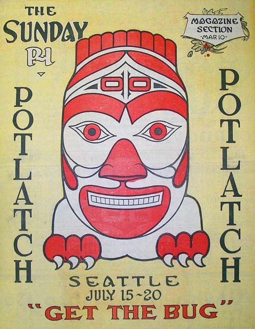
THEN: A float for the 1911 Potlatch parade carries piggyback a smaller 1897 version of a Polk City Directory on a much bigger 1911 copy. The fourteen years between them is meant to symbolize the growth of the city since the Alaskan/Yukon gold rush of 1897 that the Golden Potlatch of 1911 was created to commemorate. (Courtesy, Lawton Gowey)NOW: With his back close to Stewart Street, Jean Sherrard looks across Fourth Avenue to the front facade of the Thirty-story Escala Condos.
Riding its own float south on Fourth Avenue is, perhaps, the largest Polk City Directory ever assembled, although not published. It is dated 1911, the year of this “Industrial Parade” for what was Seattle’s first Golden Potlatch, a summer celebration staged intermittently until World War Two.
Fourth Ave. has been freshly flattened here for the Denny Regrade, a public work that by this year reached Fifth Avenue and then stopped, leaving on its east side a steep grade – in some places a cliff. On the far left horizon, the belfry for Sacred Heart Church still stands high above Sixth Avenue and Bell Street. Both were razed in 1929, along with what remained of Denny Hill east of Fifth Avenue.
This one is closer to 5th Avenue than to 4th, although both the Denny School, far left, and the church belfry are easily found. The cliff running across the photograph was groomed and worn through the next nearly 20 years, but still held during those years as the eastern border of the Denny Regrade until the lowering of the whole hill continued in 1929 to the east of 5th Avenue. (Courtesy Mike Maslan)
Those are not helpful monks from the neighborhood parish guiding the horse-drawn float, but volunteers dressed in cowls of the Potlatch pageant’s own design. When first delivered fresh from their Chicago factory and unveiled early in July (the Potlatch month), a Seattle Times reporter described them alternately as “insuring a brilliant or gorgeous display.”
Across Fourth Avenue, the covered VIP reviewing stand below the Welcome sign was the first of many sections of bleachers constructed to the sides of both Third and Fourth Avenues. With thousands of seats offered for week-long rent to anyone with a dollar to spare, they helped pay for Potlatch, a celebration that this paper explained would “be first, last and all the times a joy session. Seattle is going to pull the top off the town and let the folks see what it looks like when it is really going some.”
To anyone who has pursued a study of local history, Polk directories are downright endearing. First published in Seattle in 1887, they grew with the city until the company abandoned them in 1996 for “digits” – disks, that is, and on-line services. Over forty years I have managed to collect about forty Polks; most of them recycled copies bought from the Friends of the Seattle Public Library’s annual book sales. All are big, and all were worn when I first got them. A few I have bound with sturdy rubber bands. They surround my desk, because I keep using them.
WEB EXTRAS
Anything to add, Paul? Certainly Jean, and we will start with Ron’s harvest of appropriate links, this time all from the neighborhood. I’ll follow that with a few more Potlatch Parade pics. We have, you know, inserted above other 1911 Potlatch parade photos with more floats and most of them on Fourth Avenue north of Stewart. (By the way Jean, we expected that you would include this weekend some snaps from your and Karen’s trip to Southern California. Any chance for adding the same soon?)
THEN: Sometime before her first move from this brewery courtyard in 1912, Lady Rainier was moved by a freeze to these sensational effects. She did not turn her fountain off. (Courtesy of Frank & Margaret Fickeisen)NOW: Much later Lady Rainier was moved to South Seattle to the ground of what was Rainier Beer’s first brewery. Now many hear her yearning for a safe return to Georgetown.
Here is Lady Rainier, bronzed and ten-feet tall, holding her glass high while standing in the brewery courtyard. She first appeared in the Seattle Times on February 7, 1904, for this paper’s “industrial review” of The Seattle Brewing and Malting Company. Within an elaborate montage of mostly brewery interiors, the Times included the fountain. The paper explained, that it had been “made especially for the Rainier Brewery and imported from Germany (and) is a work of art and would grace any of the city’s parks. When the water is turned on, it sprays over the glass giving the effect of foam flowing from the side.” In this undated portrait of the Lady in her courtyard, the flowing foam effect has been “interpreted” with ice.
Part of the facade along Airport Way, ca. 1990
Georgetown historian Tim O’Brian, now deceased, liked to compare his early twentieth century brewery town – before prohibition – to a medieval community where crowded in the shadow of its cathedral was everyone and everything. Here in place of a narthex, nave and chancel were a line up of Malt House, Brew House, and offices extending along Georgetown’s Snohomish Way (now Airport Way). Tim boasted, “At 885 feet it was a few feet longer than St. Peter’s Basilica in Rome – although not as wide.” When completed in 1903 and fitted with its fountain, the “Georgetown Cathedral” could readily claim devotional status as “the largest brewery in the west.”
over the tracks
By 1906 Rainier brewery was producing 300,000 barrels of beer – or spirits – a year. It required twenty-five horse teams to handle deliveries consumed daily in Seattle alone. But the Golden Gate State statistics were the most impressive. In 1911 if you were drinking beer – or shampooing your hair with it – most likely it was with Rainier. On average twenty-five carloads of Rainier Beer were delivered daily by rail to California.
When the expanding brewery needed the Lady Rainier’s courtyard for a machine shop, she began her pilgrimage to several locations in and even atop the brewery. Too soon, however, Georgetown’s “only employer” was turned off as was its fountain – first for statewide prohibition in 1916, when the company moved to San Francisco. National prohibition followed in 1920.
In this week’s repeat, Lady Rainier looks down from her perch beside the “other” Rainier Brewery, also on Airport Way, but in South Seattle, less then two miles north of the remnants of the Georgetown Brewery. In recent years the Georgetown Community Council has hoped to bring the Lady home to Georgetown’s Oxbow Park to stand beside another restored and protected Georgetown landmark, the Hat ‘n’ Boots.
MOVING LADY RAINIER
Georgetown historian Tim O’Brian thought that 1959 was the likely date for this moving of Lady Rainier.
WEB EXTRAS
Anything to add, Paul? YUP! Ron Edge first. Ron will attached to images that will link to two former Features that relate. I’ll follow that with a few Georgtown photos – and Rainier Beer too.
CLICK-CLICK TO ENLARGE
HOW TO BE SICK
Last week’s stay in the University of Washington Hospital answered many years of wondering what it would be like to be put in a bed there. The irritation of being awakened thru the night for samples and tests is softened by the generally good humor of those – nurses mostly – who are poking you awake. And when my appetite returned I was hoping to stay longer, for the menu is quite good and the preparation too. Rather I was encourage to get out during my 5th day, and so with Jean and Genny’s help I left with my four drugs and a long list of appointments for more tests and a variety of acts called procedures. Now to confirm for Marc Cutler – of both the Old Fools and the Not Dead Yet societies, I am, indeed, not dead yet.
Paul, just before going home with color back in his cheeks
THEN: Frank Shaw’s pre-preservation visit to First Avenue South on February 26, 1961. He looks north from Main Street. (photo by Frank Shaw)
NOW: Jean Sherrard’s return for his repeat gives equal exposure to the preserved landmarks lining both sides of First Avenue South.
Here, for the third week running, we belatedly thank Frank Shaw for another cityscape he chose to record with his Hasselblad camera on one of his winter walks in 1961. Standing off the curb of First Avenue South on the evidently idle Sunday of February 26, Shaw aimed north from Main Street through the two blocks that were for Seattle’s first half-century the principal commercial strip for this ambitious town. Commercial Street, not First Avenue South, was its name until the city’s “Great Fire” of June 6, 1889. Following that destruction, some of the avenues in the burned district were widened and here south of First Avenue the descriptive name “Commercial” was abandoned for the commonplace First Avenue.
On this Sunday in February, Shaw could safely step from the curb during his hometown sight seeing. For his repeat Jean Sherrard made the prudent choice of standing on the planted median strip. This landscaping was one of the charmed improvements made later on First South during the polished restoration of Seattle’s Pioneer Square Historic district – about twenty blocks of it.
Standing at the center of First Avenue South also allowed Jean to show us the sandblasted vitality of those enduring landmarks that stand to both sides of the historic street. What Shaw saw in 1961 was brick walls slathered with carbon grime and cosmetic colors and the often neon names of the street’s many taverns, single room occupancy hotels, hardware stores, loan-pawn shops, cheap-suits shops, and a few missions.
Judging from my familiarity with his many photographs, I’m confident that Frank Shaw delighted in this subject’s primary tension – that between this historic street of worn landmarks and the nearly new Norton Building (1959), which fills the center of this cityscape. Here, with its glass curtain walls, is Seattle’s first oversized demonstration of austere international modernity looming above this worn (but not worn out) old town neighborhood like a lower court judge with clean fingernails looking down from his high bench at the morning line-up of drunks, pickers and survival improvisators.
Now, a half-century later, we know the verdict. First Avenue South and many of its neighbors were saved. A mix of heroic forces for historic preservation had it over the cadre of Seattle politicians and developers who proposed razing both our Pioneer Square neighborhood and our community market at Pike Place in the name of “urban renewal.” They envisioned mostly more Nortons and convenient parking lots. And Frank Shaw would be there through it all recording many of the heartening victories for preservation.
WEB EXTRAS
This week, extras will run late, we fear. We’re engineering a switch to new servers and expect several bumps along the way.
Nevertheless, one ‘Where’s Waldo’ treat: for the eagle-eyed, spot friend of the column, John Siscoe, poised at the street corner in the ‘Now’ photo, only a few feet from the doorway of his delightful Globe Bookstore.
Back in the 80s and 90s, John and Jean worked together on the Globe Radio Repertory, producing radio theatre for NPR PlayhouseIf you have the chance to visit, be sure and ask John about the Duchy of Grand LIchtenstein
That’s it for now. But we’ll be back on a new server next week (cross our fingers).