The only identification with confidence here is “Lust for Life,” the 1934 novel by Irving Stone pulled from the brilliance of the letters that Vincent van Gogh wrote to his brother Theo. It is the orange book on the bottom of the pile resting on the table in the lower slide. I suspect that the persons remembered here are both relatives of Horace Sykes – ones living in Oregon. I surely do not know that and there is little chance that these two delicate figures will ever be identified. However, portraits like these are very rare in the Sykes collection, and the most of them – the ones that are identified – are of members of his family and a few of their friends, most often at Christmas. (Click to Enlarge)
Cosmetics on shaped rock, suggestive like some clouds more than tea leaves, like oil stains in the street and pick up sticks: pictographs. (Click to Enlarge)
For Horace Sykes a rare city subject - the brand new Seattle Post-Intelligencer building got his attention. The P-I with its globe entered service for Seattle's oldest daily pulp in 1948 and remained here at 6th and Wall until 1988 when the Hearst vehicle moved nearer the shores of Elliott Bay and took its ball with it. (Here we will whisper "iconic.") As then suspected, it was the P-I's second big step to dissolution. The first was its "Joint Operating Agreement" with The Seattle Times. The JOL was launched in 1983 before the move. At the time persons working both at The Times and The P-I foresaw the failure of the P-I and wore special t-shirts lamenting their premonitions. And yet - to indulge a strict mixing of metaphors - it took a quarter-century for the folding to unfold. (Click to Enlarge)
When the Theo Erdman and Ida Girena Christiansen-Dorpat family moved from Grand Forks, North Dakota to Spokane, Washington in 1946, we all understood that we would soon be living with the power of the Grand Coulee Dam's generators and of its reputation as one of the modern wonders of the world. It was on the short list of marvels, and then still the largest construction in the world, when measured by how long a two-lane highway one could make from the cement needed to make the dam. By now its superlatives have been surpassed and I do not remember the miles of the imagined highway. The spectacle of the dam's cascades were ordinarily dampened by its east-west position. The spillway looks roughly north and so is ordinarily back-lighted. (Click to Enlarge)
THEN: Throughout much of the first half of the 20th Century, the Pike Street Dock, here on the right, was home to the fishing fleet. If that is snow marking the roof of the Schwabacher Wharf, on the left, the fleet is here on a winter break. (Courtesy Lawton Gowey)NOW: For the “now” Jean Sherrard includes sculptor James Fitzgerald’s fountain at Waterfront Park, which he visited earlier this year for a repeat of a photograph taken during its construction and printed in Pacific last Feb. 20.
The Pike Street Dock (or pier or wharf), here on the right, welcomed Pacific Net and Twine as its primary renter in 1916, and so began the pier’s preoccupation with fisherman and their needs. The wharf in its enduring landmark size was built in 1903-4. The new dock’s principal tenants then were diverse and included, fish merchants, grain dealers and shipping companies.
With Pacific Net and Twine in residence, the dock became the central waterfront headquarters for the fishing fleet which often – as here – packed the slip between itself and the Schwabacher Pier, to the south and here on the left. Many of the fishermen’s voluntary groups like the Fishing Vessel Owners Association and the Purse Seiners’ Association took residence on the Pike Dock and a variety of sail-makers, fish brokers, and other specialists in supplies for the fisheries had offices there as well.
The Schwabacher wharf was the older pier. It was in this slip that the gold ship the S.S.Portland made its historic call in July 1897 with a “ton of gold” and thereby launched the gold rush north to the Yukon and Alaska. An older and smaller version of the Schwabacher pier just escaped the city’s “great fire” of 1889, and for weeks following it most of the materials for rebuilding the business district entered the city across its then mostly uncovered deck.
Recent history of this slip begins, we will say, with the destruction of what remained of the old Schwabacher Dock in 1967. The city purchased – without condemnation – the Pike Pier in 1973 for a bargain of $585,000. Two years earlier Mayor Wes Uhlman switched his advocacy for building a Forward Thrust (1968) funded Aquarium in Ballard to the Pike Street Pier. Construction on Waterfront Park (seen, in part, in the “now”) began in the fall of 1973. By the late 1970s both the park’s promenades and the aquarium’s tanks served a, by then, mostly playful central waterfront.
WEB EXTRAS
Anything to add, Paul?
Yes Jean there are a few items clinging to the sides of the Pike Pier we will put up. Much else has by now appeared in other stories – or their extras – so I’ll lean on Ron Edge to put them up next as hot-links (do you call them?). After that I’ll do some sampling. Much of what follows and more can be found in the Illustrated Waterfront History included in the “books” part of this blog.
Ron has found three primary links, and each features a string of stories and illustrations. Click on the picture (three of them) directly below and you will be carried to them.
But one of many recordings photographer Frank Shaw made on the waterfront while he was regularly visiting it in the 1970s and '80s. I admit to being mistaken about his subject. Until recently I though the reader was sitting directly on Fitzgerald's fountain.Ninety-nine feet long and propeller-driven the Dode's packet took it to Hood Canal on a day-long run as far as Hoodsport, beginning its return to Pier 3 (now Pier 54) the next morning. Here the Dode rests a the south side of the Pike Street Pier.A steamer with no apparent name rests along the north side of the Pike Pier. Like the Dode above it, this view dates from ca. 1912.
Next we’ll lay in three photographs taken of, to me, an inscrutable life-saving demonstration on a low platform in the slip north of the Pike Pier. These look innocent enough and harmless too, and may most likely be tried at home without injury. The most heroic part in this is the performers willingness to appear in swim wear on the central waterfront when all others are bundled against the cold – or at least the rain. Note the stairway to the Pike Street trestle that after 1912 crossed high above both Railroad Avenue (Alaskan Way) and Western Ave and reached the Pike Place Public Market.
The above detail from a 1911 map of the waterfront shows both the Schwabacher and Pike Street piers, and also to the proposed site for a power boat dock, which was never built. There is as yet no 1912 Pike Street trestle spanning Railroad Avenue (Alaskan Way) here.
The Bogue Plan map (1912) above includes the then new Pike Street trestle as well as two novelties that were never built. The proposed line for the Union Pacific Tunnel meant, like the 1905 Great Northern Tunnel nearby, to move trains under the city between the new Union Pacific Depot on Jackson Street and the waterfront below Belltown. The map also shows an incline on Virginia Street that would have moved teams and their wagons up the steep hill from the waterfront to First Avenue.
Another ca. 1912 look at the south side of the Pike Pier with another vessel - this one sturdy enough to steam the Pacific - the Tallac beside it.
First a detail and the below it a “now-then” of the Pike Street Coal Wharf, which was the first of many docks built at the foot of Pike Street. The photograph dates from the 1870s and was taken from the back porch or window of the Peterson & Bros photography studio on Front Street (First Avenue) at the foot of Cherry Street. The contemporary scene (from ca. 1990) was recorded from the parking garage that extends a block south on the west side of First from Columbia. The “now” prospect is much higher than Peterson’s, whose view was not obstructed my structures on Post Alley.
This detail "pulled" from the Peterson & Bros view, directly below, shows both the east end of the Pike Coal Wharf and the incline, on the right, which climbs the bluff to Front Street (First Ave.) with the narrow-gauged rr-track that ran on Pike and the future Westlake to the south end of Lake Union, where the little engine-that-could, named the Ant, moved the coal-filled cars from barges to the tracks and this last leg of the complicated run that began in the coal fields on the east side of Lake Washington. This system continued until 1878 when the new coal railroad, The Seattle and Walla Walla, reached Coal Creek, Newcastle and Renton directly around the south end of Lake Washington from the new coal wharf and bunkers at the waterfront foot of King Street.
The ruins of the abandoned Pike Street Coal Pier seen from Yesler's Wharf ca. 1881. The modest summits - south and north - of Denny Hill are also apparent. Queen Anne Hill is on the horizon. (Courtesy U.W. Libraries)Detail from the 1891 Birdseye of Seattle shows the waterfront north of Union Street with Denny Hill above it, including the Denny Hotel, upper-right. Splotchy but revealing, this scene looks north along the waterfront from the King Street Coal Wharf, ca. 1902 or 3. The dock at Pike Street is a small one with a stepping waterside facade, seemingly third from the right. Actually four from the right because the odd-angled Schwabacher Dock is in there too just to the right of the Pike Pier. The long white-sided pier center-left is the Gaffney Dock near the foot of Virginia Street. Beyond it is the Coast Company's longitudinal dock, which paralleled Railroad Avenue because Elliott Bay was deeper there and building a finger pier directly into the bay prohibitive. Right to left are the Wellington Coal Dock, the Schwabacher Dock, the Pike Street Pier, the two smaller "fish docks" and part of the Gaffney Dock. Also showing it the Pike Street Trestle which "carried" pedestrians safely from the water side of Railroad Avenue back and forth to the public market.Mayor/Dentist Brown's mid-1920s proposal to built a grand pier and on shore an attached commercial structure - and early threat to Pike Street Public Market - failed.Another of the W.P.A. Tax-Inventory photos from ca. 1937. Here the Pike Street trestle has not been rebuilt to cross Railroad Avenue after it was dismantled for the 1934-36 construction of the seawall between Madison and Bay streets.A circa 1934 aerial of the waterfront that shows Railroad Avenue still with its "centerline" of a dangerous drop-off to the beach. This was filled in and covered with the 1934-36 seawall construction. The Pike Street Trestle is here still intact.The Pike Street Pier from . . . when? Another threat to the Pike Place Public Market - the urban renewal proposals of the early-mid 1960s. The Market neighborhood in 1967-8. The Pike Street Pier is lower-right. Finally - this week - a quiz or contest, and still in the neighborhood. The subject dates from ca.1978, and if you were not there this will be tough. Who is the man behind the counter, and what public market restaurant is this? Hints - note the decorations. The man behind the counter - dish washing - opened his namesake gallery in the mid-60s. It was shot-lived but very influential on the local arts scene (With such a helpful hint it feels like I have almost given up the answer.) Our puzzling subject left it to spend a year reflecting on the shadows cast by cloudless skies and moving across the walls of his rented studio in Kabul Afghanistan. Our subject was it seemed, at least, beloved by all who knew him. It was an attack by strangers later on the Seattle Center grounds that weakened him so that it lead to his death.
Among the hundreds of Horace Sykes own slides are a few by others, most often members of one or another of the photography clubs he belonged to. Club members would sometimes travel together on club excursions. For instance Ira S. Doyle and Horace were part of a group that visited - if my memory serves me well enough - Hells Canyon together. We have a slide showing Horace at the Canyon, which is signed by Ira. And here is another Ira slide that is folded into the Sykes collection. I include it for contrast. While Horace is always concerned about finding another expression of sublime nature and values the qualities we count as picturesque, this view of nature - the 1000 springs - is fronted by some sort of utility structure - a station serving something - that is quite the opposite of picturesque. And yet we do get these waterfalls, which by the banal context created with this snapshot, come forward as freaks of nature. We will wonder if Ira had a handle on the irony. Whatever, he sent the slide to Horace - perhaps as a request. It may be a subject that Horace Sykes wanted for some unexplained reason but which he was not able, or would not dare to impetuously interrupt his photographic dream, to take himself. (Click to Enlarge)
Since 1984, on the third week-end of September, during the Open Days we can visit the National and Private Heritage : monuments, churches, theaters, castles, and also stop in garage sale in the street…
Depuis 1984 , au troisième week-end de Septembre, durant les Journées Portes Ouvertes on peut visiter le Patrimoine National et Privé : monuments, églises, théâtres, châteaux, et aussi s’arrêter dans les vide-greniers dans les rues…
The Mobile Art Pavilion
Le Pavillon du Mobile Art
One day in April, the Mobile Art Pavilion capsule has landed on the front of the Institut du Monde Arabe in the 5th arrondissement, its architecture is unique and very contemporary, it is signed by the Anglo-Iraqi architect Zaha Hadid. Inside, we can discover her projects, achievements and models.
Un jour d’avril, la capsule du pavillon Mobile Art a atterri sur le parvis de l’Institut du Monde arabe dans le 5 ème arrondissement, son architecture est singulière et très contemporaine, elle est signée par l’architecte anglo-irakienne Zaha Hadid. A l’intérieur, on peut découvrir ses projets, ses réalisations et leur maquettes.
Palais de Salm, Paris 7th
One of the Sphinx of the Hotel de Salm in front of the Palace of the Legion of Honor, which served as a model for the construction of the Palace of the Legion of Honor in San Francisco.
Une des Sphinges de l’Hôtel de Salm abritant le Palais de la Légion d’Honneur qui servi de modèle à la construction du palais de la Légion d’Honneur à San-Francisco.
Bourse du Commerce, Paris 1st
Here is America, painted in 1886, it is one part of the fresco in the Exchange Trade dome, 1400M2 wide, symbolizing the international trade. In the sky Christopher Columbus ‘s caravel fleet, this mural evokes the dynamism of civilization on the march meeting indigenous people.
Ici l’Amérique , peinte en 1886, une des parties de la fresque de 1400M2 de la coupole de la Bourse du Commerce qui symbolise le commerce international. Dans le ciel flotte la caravelle de Christophe Colomb, cette fresque évoque le dynamisme de la civilisation en marche à la rencontre des populations indigènes.
Garage sale rue de la Banque Paris 2nd
Vide-grenier rue de la Banque Paris 2nd
Garage sale Place des Petits Pères, Paris 2nd
The Oratoire 145, rue Saint Honoré Paris 1st
On that special week-end you can meet the organist of the Oratoire and visit all the building of the church.
Durant ce week-end exceptionnel, on peut rencontrer l’organiste de l’Oratoire, et visiter l’église de fond en comble
Or you can make photos at the door of Saint Germain L’Auxerrois Paris 1st
Ou faire des photos à l’entrée de saint Germain-l’Auxerrois
Horace Sykes visited this deep prospect in Hells Canyon by car. At the time, ca. 1949, there were no dams in the canyon. Three were eventually built, and the last of these, the Hells Canyon Dam, was built here. Horace's prospect is from near the present spillway behind which the river is about 150 higher now than it was then. Horace, again, did not caption his slide, but I found the location with another flight via Google Earth. The mountain at the scene's center - with the green top - reaches about 5,750 feet above sea level. The dam is much lower at 1600 elevation. The site is about 20 miles down stream from the Oxbow dam where Oregon State highway 86 reaches the river and crosses it with a bridge. Horace reached his prospect on the now paved road that continues north along the Idaho side of the canyon and includes some of the more exposed driving in the northwest. It is not recommended for someone timorous of heights. The Hells Canyon Dam began producing power in 1967. It was, of course, to the considerable injury of the fish that once made this one of the great spawning paths. It is about 8 miles below the Seven Devil mountains on the Idaho side (to the right) and about 10 miles south of Hat Point on the Oregon side, which Horace also visited and photographed. Hat Point is more that 6900 feet elevation and the Devils reach over 9000 feet. These elevations make this the deepest canyon in North America. Sometime after Horace's visit the Hells Canyon Creek Visitors Center was opened just downstream from the dam and around the first corner or bend in the road that shows here on the Oregon or left side. (Click to Enlarge)The Google Earth image above-left is recorded (by some computer's calculation) from directly behind (south) the Hells Canyon Dam's spillway. If I have calculated this correctly Horace Sykes slide of the same general scene was taken from a location somewhat south of the computer-position and so now about 150 feet underwater. (click to enlarge)
Among Horace Sykes slides are one hundred or so copies of paintings. These two are identified with names attached to their frames. The names, however, are either wrong – actually misspelled – or no longer in use. First what the unknown painter has named Crossley Lake is Cosley Lake.
Joe Cosley was a hunter-trapper who frequented this area and later worked as a park ranger once his hunting ground had been nationalized as a protected park. Cosley Lake is about 10 miles north of what was called Lake McDermott, the name used by the painter on his frame, before it was changed to Swiftcurrent Lake. It took awhile to sort this out. There are quite a few postcards of McDermott Lake on line but none that I found indicated where in the park it was. One of the cards described it as near Mt. Wilbur and Mt. Grinnell, so I went looking for them.
Soon I was confident that the little lake named Swiftcurrent, with the largest hotel in the park (Many Glaciers Hotel – and many rooms too), was once named McDermott after a lumberman in the late 1890s. And I also found the waterfalls at the western end of the lake. The name was changed from McDermott to Swiftcurrent in 1928, perhaps because the creek was so named and also the popular mountain pass and trail that cross the divide and lead one to Lake McDonald on the west side of the park. Swiftcurrent lake is only about a quarter mile wide when measured east-west directly across from the hotel. The painting also looks west and a little south. One half mile behind the painter is the western end of the six-mile long finger lake, Lake Sherburne. An earth dam was built at its western end and the lake is now a reservoir for ultimately irrigating the farm lands of Montana and Canada to the east of the park and to the sides of the Milk River.
The Teepee in this charming but primitive painting has a cartoon size. The mountain upper right is Cleveland, the highest in the park. The artist has signed his painting on the bottom-right corner, but I cannot figure it, and Horace Sykes' slide is not in the sharpest focus. (click to enlarge)The same artist on the wing of a crow could have made is south and a little east form Crosley Lake with his brushes and the rest to Swiftcurrent/McDermott Lake in less than ten miles. But along the way there would be a few high peaks to cross or fly around. The artist's actual trip may have been four times as long as the bird's. Mt.Wilbur is on the right, Mt. Gould on the left and Grinnell Point dominates the center. It was George Bird Grinnell who is credited with being the main mover behind the making of Glacier National Park. In 1887 Grinnell was the first non-native to walk on the glacier that was named for him then by Lt. J. H. Beacon who accompanied him. By now much of Grinnell Glacier is gone and the same is true with the rest of the park's namesake ice. Grabbing a montage of related images, which include on the far right the photo of Wilbur Mountain and "McDermott Lake" that helped me identify it as Swiftcurrent Lake.The top highly saturated and retouched look at Swiftcurrent Lake and the now familiar mountains beyond it includes the waterfall depicted in the painting.
THEN: Looking south across Spring Street and into the pit along Third Avenue for its 1906-7 regrade. (Courtesy Lawton Gowey)NOW: Jean Sherrard used his ten-foot extension pole again to reach an altitude more in line with the old grade of Third Avenue before its reduction.
The steam shovel at the intersection of Third Avenue and Spring Street works on making one of the deepest cuts during the Third Avenue Regrade, which extended the eight blocks between Cherry and Pike Streets. Like Biblical signs, the shovel spews the good and the bad – steam and smoke – from its roof. An empty wagon waits for the shovel to pivot with its first contribution.
Behind the rising effluvium are a row first of storefronts holding a laundry, a plumber and an undertaker. Beyond them is the popular Third Avenue Theatre with the open tower at the northeast corner of Third and Madison. Its 16-year run is about to end a victim of grade changes on Third. Across Madison are two more towers, both churches. First, the First Presbyterians at the southeast corner with Madison and one block south the second sanctuary for the first congregation organized in Seattle, the Methodist Episcopal Church at Marion Street. Both parishes moved to new sites because of the regrade.
Upper left is the west façade of the Lincoln Hotel at the northwest corner of Madison Street and 4th Avenue. The regrading on both Fourth Avenue and here on Third were temporarily stopped in the summer of 1906 by an injunction brought by the hotel charging “damaged property” – indeed. More than damaged the hotel was destroyed by fire in 1920. The regrading of both Third and Fourth Avenues was necessary, it was explained, if the retail district was to spread east. First and Second were both filled and the steep climb to Third and Fourth needed to be eased.
Frank Carpenter, a visiting journalist featured in the Post-Intelligencer under the head “Ourselves As Others See Us,” described 1906 Seattle as a “city of ups and downs. It has more hills than Rome . . . The climate here gives the women cheeks like roses . . . I am told that men measure more around the calf and chest than anywhere outside the Swiss Mountains. The perpetual climbing develops the muscles and at the same time fills the lungs with the pure ozone from the Pacific.”
WEB EXTRAS
Anything to add, Paul?
Yes Jean and we will keep to Third Avenue, or not stray too far from it. First with the help of Ron Edge of our sometimes feature, “Edge Clippings” and our maps too, here are a few links to past blog stories that include within them at least some Third Avenue subjects.
May 8, 2011 - Looking North on 3rd Ave.
Jan. 29, 2011 - Lake Union from Smith Tower
Aug. 6, 2011 - Denny Knoll's Death Knell
July 30, 2011 - 3rd and Pine 1917
Jan. 15, 2011 - Central District from Harborview
May 15, 2010 - Lewis Whittelsey’s Survey
May 1, 2011 - The Public Safety Building
Continuing on, here follows a sampler of Third Avenue subjects.
Looking east and a little south from 2nd Avenue to 3rd with the Madison Street regrade on the right and the 3rd Ave. Theatre at the northeast corner of 3rd and Madison on the left. Top-left is a peek at the Lincoln Hotel, which we will return to at the end of this string.North on Third Ave. from the Madison Street trestle for the cable line and during the 3rd Ave. Regrade. The spire of Plymouth Congregational Church shows cemter at University Street. To the left of it is what remains of the ruined Washington Hotel atop Denny Hill. (Courtesy Lawton Gowey)
MADISON TRESTLE OVER 3rd Ave. REGRADE
(First appeared in Pacific May 16, 1999)
The intended subject here is the apparatus of the Madison Street cable line, exposed during the 1906-07 regrade of Third Avenue. We can see the cable beneath the center slots for both tracks, and the supporting architecture is extraordinary – stacked 6-by-6-inch timbers hold the cable car on the westbound track while Third Avenue is lowered beneath it.
It seems that car No. 37 of the Lake Washington and Madison Street cable line has paused at Third Avenue (let loose of the moving cable) to pose for the photographer. The conductor is posing as well, a coin dispenser wrapped about his waist. The man on the tracks just left of the westbound cable car flaunts the commands of the banner strung over Madison Street, far right, one block east at Fourth Avenue. It reads “ALL PERSONS ARE· FORBIDDEN To Walk On Street Car Tracks.”
The original Asahel Curtis print is dated Jan. 25, 1907. On this Friday, The Seattle Times carried a photograph of the Third Avenue Theatre, showing here in the full sun•
light behind the cable car. When the regrade on Third Avenue reached a level where theatergoers could no longer reach the front door, the theater went dark. The caption to The Times’ photo reveals that the theater’s managers, Russell and Drew, are about to tear it down.
Russell and Drew use their doomed theater’s billboard to advertise the play “Yon Yonson,” running the previous week nearby at their Seattle Theatre. George Thompson played the title role of a young immigrant Swede who managed to negotiate through every American “vicissitude . . . owing to his sterling honesty and bland-like innocence, which wins him many friends,” said the Post-Intelligencer’s review. The advertisement claims that Thompson is simply “the greatest of all Swedish comedians. A huge scream. A laugh in every line, and the lines are close together.”
=-=-=-=-=-=
The Third Ave. Theatre at the northeast corner of Madison St. and Third Avenue before the regrades.
THE THIRD AVENUE THEATRE
(First appeared in Pacific April 16, 1989)
The Native Americans posing in front of the Third Avenue Theater are Yakimas who performed on the theater’s stage Sunday, June 6, 1897. The montage of posters on the Madison Street side of the theater give the day and month, and Eugene Elliott’s “A History of Variety Vaudeville in Seattle” gives the year in its appendix of performances.
At the time the Third Avenue was run by impresarios Russel and Drew, who held true to the successful family formula inaugurated by showman John Cordray. Opening the theater in 1890 under his own name, Cordray offered Seattle its first “polite vaudeville,” where liquor, catcalls and the stamping of feet were forbidden.
The Third Avenue had two stages, one for variety shows – like juggling and dancing – and the other for plays usually performed by the theater’s own stock company. Occasionally, special acts such as the Yakimas (aka the Yakamas) would appear.
By the 1890s the memory of their resistance to the miners’ and settlers’ efforts to take their lands 40 years before had developed into a generally noble impression of the Yakimas’ courage, skills and loyalties. On their large reservation the Yakimas were able to resist their enculturation into the revolutionary changes occurring in the surrounding society. Exhibits of the tribe’s native skills appealed to non-native nostalgia and yearnings for a lost innocence.
The Third Avenue Theater survived till the Third Avenue Regrade, when its last stock company moved up the avenue in 1906 to Pine Street and the Methodist Protestant church remodeled for melodrama.
The Third Avenue Theatre still on Third but moved here to the old Methodist Church at the southeast corner of Third and Pine. The Methodists had moved to Capitol Hill. Beyond third is the roughage of the Denny Regrade still a work-in-progess here, although well along in reducing the hill to its current grades.
=-=-=-=-=-=-=-=-=-
THIRD AVENUE REGRADE Looking North Through MARION STREET
(First appeared in Pacific Dec. 16, 1984.)
In 1906, The Post-Intelligencer described Seattle of being regrade-mad. “The early pioneer was content to trudge up and down steep grades all day, unquestioningly, as though such things were destined to be permanent. Now any hill with a valley below it suggests a regrade.”
The historical scene looks up the Third Avenue regrade. The photograph was shot on a sunny winter day in 1907. The P-I went on to explain, “Two of the most important regrades ever undertaken in Seattle are those on Third and Fourth avenues. They are the outgrowth of the wonderful expansion of retail business. With First and Second avenues congested, the retail trade must spread . . . The cut on Third runs all the way from nothing at Cherry Street to 17 feet at Madison.”
The deepest cut was below the Madison Street cable car that passed over Third Avenue on a temporary wooden trestle shown here near the subject’s center. The pedestrian trestle in the foreground followed the line of Marion Street. The Third Avenue Theater did not survive even the Third Avenue regrade. In the historical scene, the theater is above the cable car, at the northeast comer of Third and Madison, the present site (in 1984) of the Seattle First National Bank tower. The theatre has lost the top of its corner tower. The home of Seattle’s first stock theatrical company, it ran its fare of farce and melodrama for 16 years until the regraded 17-foot cliff at its front door made it impossible for theatergoers to get into the show.
Up Third at University Street” the digging didn’t go so deep and Plymouth Congregational Church kept its services going beneath the tall brick tower seen above the cable car.
********
We peek up Marion to its intersection with 3rd Avenue and thru the Vancouver B.C. arch, the Canadian supporter-boosters raised as their part of the 1909 Alaska Yukon and Pacific celebration here in Seattle.
VANCOUVER ARCH – AYP 1909
(First appeared in Pacific Jan. 15, 1989)
The city of Vancouver’s classical arch at Third Avenue and Marion Street holds its dignified place in the history of ceremonial monuments on Seattle streets. The Canadian monument was erected for the Alaska Yukon and Pacific Exposition (AYP), which remade the University of Washington campus into a gleaming white city, and added a few downtown attractions, such as this, as well.
At the Aug. 21, 1909, dedication, Vancouver Mayor Douglas explained to Seattle: “The erection of this arch was not actuated merely by a mercenary motive, or a desire to advertise. It is a token of esteem to Seattle and the Exposition . . . It typifies the friendly feeling existing between two great cities of the North Pacific.”
Mayor Douglas concluded by making an ironic lesson of the 500 white-helmeted British Commonwealth troops in his entourage. “Evidences of this peaceful feeling have been made all the more pronounced today by the landing of British troops under arms on American soil.” Seattle Mayor John F. Miller accepted the arch on behalf of Seattle.
For all its monumental girth, this arch was razed with the AYP’s closing at summer’s end. Soon the demands of the motorcar would make, with few exceptions, such ceremonial obstructions a charm of the past.
*********
LINCOLN HOTEL ROOF GARDEN
(First appeared in Pacific June 30, 1985)
When it was built in 1899, the Lincoln was Seattle’s most elegant and prominent hotel. Reaching nine stories high, it was taller than the buildings down around Pioneer Square and taller than those along the city’s growing commercial strip – Second Avenue. The hotel’s elevated setting at Fourth Avenue and Madison Street also made it seem monumental. The Lincoln, made of white brick and stone, glowed when the sun set.
The stately poplars on Madison Street once continued up the street past Boren Ave.
The Lincoln had a garden on its roof. The vine-snarled trellis of the was slightly visible from the street. The garden was mostly enjoyed by registered guests, although painted post cards of the garden were for sale in the lobby.
The above view looks southeast toward the top-heavy cupola of the county’s courthouse (upper right) on First Hill. There on the courthouse roof is the clue that helps date this photo. Barely showing through the haze is a giant welcome sign, set there in 1908 for the Puget Sound visit of Teddy Roosevelt’s Great White Atlantic fleet. The other closer and more classical dome sets atop the United Methodist Church at Sixth Avenue and Marion Street – and still does. In1908, the sanctuary was still under construction; the congregation worshiped in the basement. Now the landmark gives some architectural soul to a neighborhood of skyscrapers.
A retouched pan of the Lincoln Hotel and its neighbors, the Carnegie Library on the right and the YMCA on the left. The view looks northwest through the intersection of 4th Avenue and Madison Street.
When it opened in 1900, the Lincoln was Seattle’s first apartment-hotel. But it didn’t stay that way. The position that gave it prominence on the city’s skyline also put it too far away from the city’s commercial district. The Lincoln was soon converted into a straight commercial hotel, but faltered in this role as well. The business passed through several managers and owners. The last was the Madison Realty Company, which bought the hotel on Nov. 1, 1919 and proceeded to sink $75,000 into remodeling the rooms as well as the shops and restaurant on the main floor.
On the morning of April 7, 1920, in the first hour after midnight, Mrs. C.A. Gross, proprietor of the cigar store, and Mrs. T., Waters, owner of the beauty shop, met for a moment in the hotel lobby before leaving for home. Their chat was quickly concluded when a man rushed by crying, “Fire!” Within the hour, the Lincoln – brick on the outside but wooden within – was a furnace. The hotel was lost including three of its guests and one firefighter. The water dumped on the fire created a river down Madison Street and Third Avenue. It was the last watering for the Lincoln’s roof garden.
LINCOLN HOTEL FIRE
(First appeared in Pacific June 8, 1997.)
First named the Knickerbocker because of its association with Dr. Rufus Lincoln, the New Yorker who financed it, the landmark hotel at Fourth and Madison opened in 1900 with elegant exterior walls of gleaming white brick trimmed with stone. Later the family name seemed more fitting for what its managers claimed was the first apartment hotel north of San Francisco.
Although the Lincoln Hotel was designed with two-and-three-room suites to attract a patronage with the means to stay a while, they did not, partly because of the struggle required to reach it. The two blocks that separated the Lincoln from the developing commercial strip, Second Avenue, were – for the cable cars that climbed them – among the steepest in the nation. The Lincoln switched to standard hotel service.
Looking east up Madison Street. The Elks Club is on the left and the YMCA on the right.
As guests discovered on the early morning of April 7, 1920, the hotel’s elegance was skin deep. It was “little more than a lumber yard with four brick walls around it ” as the fire chief later described it to a Times reporter. By the night clerk’s estimate it took only five minutes from the moment he heard an “explosive thud” in the basement for the smoke to climb the elevator shaft and make impossible his efforts to warn by telephone the nearly 300 mostly sleeping guests.
Looking east across Third Ave. to the ruined west facade of the hotel with the YMCA on the far right, the Elks Club on the far left, and the Carnegie Library across 4th Ave. showing between the hotel and the club.
The next day’s papers were filled with heroic tales of taxicab drivers, hotel patrons and firemen saving all but three guests and one fireman. Blanch Crowe, a stenographer for the popular Chauncey Wright restaurant, died in her room. A candy maker and his daughter jumped to their deaths from the top floor of the west wall. Others wanted to jump but were persuaded to wait for the firemen’s ladders. Sgt. P.F. Looker, the first policeman to approach the burning hotel, saw “a head in every window and a din of screams and cries for help. I hurried around the building shouting not to jump.”
The Lincoln looks deceptively whole - except for the light in the windows - from this prospect looking across 4th Avenue. The Elks are now on the right and the Young Christians on the left.
More likely to name a flower on a slide than a landscape, Horace Sykes captions this orchid "Cypripedium." And he adds, "Gratrixianum Aureum." The three terms are all used in orchid language, which is easily as articulated and earnestly fussy as that of spirits. Consulting wikipedia, we learn that "Cypripedium is a genus of 47 species of lady's-slipper orchids native to temperate and colder regions of the Northern Hemisphere. Some grow in tundra in Alaska and Siberia, which is an unusually cold habitat for orchids . . . Common names include slipper orchid, lady's slipper, mocassin flower, camel's foot, squirrel foot, steeple cap, Venus shoes and whippoorwill shoe." Of most relevance here is "Venus." On the webpage orchids.co.in we learn that the paphiopedilum gratrixianum is an undemanding Venus's shoe of average beauty, attractive for cultivators for its fairly large flowers and very low cultivation requirement." But hold on. With this gratrixianum we are no in Alaska but rather "the species come from Laos, northern Vietnam and Thailand." This example, whatever its name, sits potted on a sideboard in the Sykes Magnolia home, in direct sunlight off Puget Sound. Horace certainly loved his orchids. There are hundreds more slides of them.
Thanks to Jean Sherrard, we discovered the West Coast from San Francisco to Seattle, a fifteen-day trip filled with surprises and wonders.
Grâce à Jean Sherrard, nous avons découvert la côte Ouest de San-Francisco à Seattle. De surprises en merveilles, notre voyage a duré 15 jours.
Once upon a time, the Redwood forest covered large areas in Northern California and Oregon. Today, it is still wonderful to contemplate this mythical forest inhabited by thousand-year-old trees.
A l’origine, nous pouvons imaginer que la forêt de Redwood recouvrait de grands territoiresen Californie du Nord et dans l’Oregon, et c’est aujourd’hui merveilleux de pouvoir encorecontempler cette forêt mythique peuplée d’arbres millénaires.
Crater Lake remains for me one of the most fascinating sites : the huge lake in the heart of an extinct volcano, the intense blue of its pure water, its reflection, its depth (the seventh deepest lake in the world ) and Wizard Island, a small volcanic cone from the last eruption encourage meditation.
Crater Lake demeure, pour moi, l’un des endroits les plus fascinants : cet immense lac situéau cœur d’un volcan éteint, le bleu intense de son eau pure, sa réflexion, sa profondeur (le7ème lac le plus profond du monde) et Wizard Island, petit cône volcanique datant de ladernière éruption incitent à la méditation.
In the course of this wonderful journey, we crossed forests, climbed along the cliffs, and visited beautiful seaside resorts. We have stayed on the island of Whidbey and hiked through the golden canyons of the Yakima River. The long beaches of LaPush with their lush forests, rocks, mysterious mists and all the power of the Pacific Ocean — gave me the feeling of being the first human to discover the shores of the unknown land.
Dans ce merveilleux périple, nous avons traversé des forêts, longé des falaises, nous noussommes arrêtés dans de magnifiques stations balnéaires, nous avons séjourné dans l’île deWhidbey et marché dans les canyons dorés de Yakima river. Mais les longues plages deLaPush bordées de forêts luxuriantes, ses rochers,, ses brumes mystérieuses, la force del’océan Pacifique donnent le sentiment d’être le premier être humain foulant le rivage de laterre inconnue.
Among Horace Sykes hundreds of slides are about a half dozen sandwiches. I have done it myself years ago. It works best with overexposed slides - two of them. You fit them together in a slide holder.
Almost deep enough for Hells Canyon, but not that canyon from Hat Point on the Oregon Side. It takes a bit of endurance to drive up to Hat Point, but Horace did it ca. 1948. There's little or no evidence that he visited the Idaho side of the our deepest canyon. I think this is more likely near Hells Canyon than above the canyon itself - an Oregon tributary to the Snake River. (Click to Enlarge)
This reminds me of a college course in aesthetics. The professor - Yates was his name - chose a principal text that promoted "spatial relations" as what art was "about" or concerned with. The class did not object or resist this reduction. Like converts having no former religion we embraced it. If one gives "spatial relations" an opportunity or a break it will grow on one. Everything has them. "If a physical object happens to be fairly firm and coherent internally and extends up, down, north, south, east, west, hence and ago, it is likely to be called a body." And that is just the start. (Click to Enlarge these Spatial Relations)
Once also known as Boulder Dam, built in the Black Canyon of the Colorado in the early 1930s, took years to fill and in the process deadened the Colorado River estuary below the dam, killed more than 100 workers during the construction, described with superlatives but soon lost them to the Grand Coulee Dam, which was built soon after. (Click to Enlarge)
This is our fourth or fifth visit to the Grand Canyon of the Colorado with Horace Sykes. Here the sky is in a dance with the canyon. (click to enlarge)
THEN: Clumsily promoted as “The Nation’s Greatest Playground on the Pacific Coast” Luna Park was “thronged” after it opened in the summer of 1907. During its first Independence Day, Lewis MacEvoy and Angela May claimed to have sold to the crowds on this gated platform more than 4000 copies of their new song “All Aboard for Luna Park.” (Historical pix courtesy Oregon Historical Society)NOW: In the spring of 1931 the last attraction at Luna Park, its natatorium, was torched by an arsonist. Later the pool’s sturdy tank was used in the construction of the small park that reaches with fill 100 feet beyond the shoreline. At the lowest tides some of the piles of Luna Park are exposed.
Extending over the tideflats below Duwamish Head it could be seen from almost everywhere. The lolling tidelands off the Head were too shallow for ships but not this sprawling boardwalk raised on piles for amusements. Once the two tardy boilers were installed in its own power plant, Luna Park was its own billboard, shining across Elliot Bay and up and down Puget Sound.
With the staccato of a running headline, the Friday Seattle Times for June 23, 1907 announced “Luna Park Now Open to Public. Seattle’s Coney Island is Visited by Throngs. New Ferry and New Car Line in Operation. Thronged with People until a Late Hour.” Two days later Youngstown, Alki, Spring Hill and West Seattle voted 325 to 8 for annexation into Seattle. The Times report concluded, “Georgetown is left entirely surrounded.”
Although not evident here at its grand gate, for many of Luna Parks attractions Seattle Architect James Blackwell used the exotic – for Seattle – Spanish style typical of Southern California, like the House of Alhambra, that Blackwell pasted into his picture scrapbook. The rides and amusement were proven ones used at other amusement parks like its namesake, New York’s huge Luna Park at Coney Island. Here to the right of the gate the “scenic railway” called the “Figure Eight” reaches 150 feet, its highest point. From there the ride was embellished with the published claim that it “winds for nearly half a mile through the air.”
The busiest issue during the amusement’s construction was whether or not the West Seattle City Council was correct to give Luna Park a liquor license. The developers had promised that the sale of intoxicants would be conducted properly. This propriety ran out with bad news. For instance, a Post-Intelligencer reporter riding a packed trolley to town after a Sunday Night Dance at the park, noted “The boisterous conduct and the indecent language of the joy-dancers disgusted the respectable patrons of the line.” Except for its cleanest amusement, the natatorium, Luna Park was closed in 1913.
(The top comparison is one of the “now-and-then” features included in Jean Sherrard, Berangere Lomont and my exhibit titled “Repeat Photography” on show at MOHAI thru June of 2012.)
WEB EXTRAS
Anything to add, Paul? Oh a few things Jean, and sticking close to Duwamish Head too – with the exception of something on Sea View Hall.
Above: Between 1888 and 1890 the West Seattle Harbor was developed by the West Seattle Land and Improvement Company, which had residential lots to sell atop Duwamish Head. The view looks north over Elliot Bay to a horizon of Magnolia on the left and Queen Anne Hill on the right. (Courtesy, Lawton Gowey) Below: Trees, on the right, now obstruct the view from Ferry Avenue, on the left. The waterfront seen in the ca. 1890 view was greatly changed with the 1913-18 reclamation and 1924 paving of Harbor Avenue. (Now photo by Jean Sherrard)
WEST SEATTLE HARBOR, EARLY VIEW
This may be the earliest intimate birdseye of the West Seattle harbor. I have grabbed 1890 as it’s date on the evidence of a sketch that appeared in the “Graphic,” a Chicago-based publication that this year included a fulsome article comparing West Seattle to the best that Switzerland had to offer in the way of sublimity. The Graphic’s line drawing of the harbor is in every detail the same as this photograph although it was copied from another photograph taken almost certainly within moments of this one a few feet further southeast on what was then the clear cut and exposed Duwamish Head.
The ferry “City of Seattle,” far right, is moving (it is streaked) into its slip after a run from the Seattle Waterfront. The inaugural trip was made on Dec. 24, 1888. The long Northern Pacific spur that runs through the scene between the ferry and the waterfront was completed in August of 1890. And the two-mile-long cable railway that looped up Ferry Street to the West Seattle addition atop the ridge and back down California Way Southwest to the developer’s headquarters, the big boxish building far left, was formally opened on Sept 6, 1890 with much hoopla.
California Way and Ferry Street meet on the far left of the ca. 1890 view. Neither can tracks be seen running near the center of those streets nor can we be certain that they are not. Like the N.P. spur from Seattle these cable railway tracks were also laid during the summer of 1890.
The homey titled Washington Magazine raised its own 1890 cheer for this harbor. “The landing at West Seattle is very attractive . . . owing to the substantial character of its construction and the beauty of its surroundings . . . What more can be said about West Seattle, except that it will be to Seattle before a year passes what Brooklyn is to New York and Oakland to San Francisco.”
*******
HOW TO GET TO WEST SEATTLE
(First appeared in Pacific on Sept. 12, 1982)
Inquiries on how to get to west Seattle often conclude with the question of why go there. And for years, if there was no dugout canoe to be had or hired, the answer was “you can’t get there from here.”
These recurring questions of why and how to go to West Seattle were ones David Denny probably asked himself many times as he waited for his brother Arthur to find him at Alki Point. David had preceded the “Denny Party” to scout for a settlement on Puget Sound. The Denny Party finally arrived on a wet Nov. 13, 1851.
Fifty-four years later a few survivors of this damp landing, in company with a large party of supporters, returned to that West Seattle beach. There they unveiled a pylon that memorialized themselves as the “founders of Seattle.”
But many others claimed Seattle “began” in mid-September, 1851, when the area’s first settlers, including Henry Van Asselt and Luther Collins, staked claims on the Duwamish River in South Seattle, not West. Others objected that the city was more properly “founded” in 1852 when the Dennys and others abandoned Alki Point and marked new claims on the protected east shore of Elliott Bay. From this Seattle site, Alki Point was hidden behind what the Indians called Sqwudux and the settlers called Lamb’s Point. Today we call it Duwamish Head.
And there were other names. In the 1860s it was changed to Freeport, until 1877 when a Capt. Marshall spent enough buying up Freeport to call it Milton. A year later in 1878 the citizens of Milton heard Colonel Larabee sing “Suwannee River” over a telegraph wire converted for the first local demonstration of the telephone. (He might have recited a short passage from Paradise Lost, if there was one.)
City of Seattle Ferry, far right, beside its Marion Street slip.
Milton was first called West Seattle in the late 1880s when the questions of why and how to get there were first seriously answered by the West” Seattle Land and Improvement Company. This group of San Francisco capitalists bought a lot of land up on the bluff for marking and selling view lots; encouraged development along the waterfront with a yacht club, shipyard, boathouse and first regular ferry service from Seattle on the City of Seattle; and started the area’s first community newspaper. And the news spread.
The gangplank on the West Seattle Harbor Ave. side.
An 1890 issue of the Chicago publication, The Graffic, featuring Washington State, exclaimed, “Hundreds of spots of rare beauty may be found in the state of Washington, but surpassing all others, West Seattle easily stands out as the most attractive of them all.” The Graffic’s praise could not contain itself to the Western Hemisphere. “Switzerland, despite the wealth of magnificent scenery has nothing comparable . . . the wild, rugged and imposing; the soft, harmonious and sublime; the beautiful, magnificent and glorious; all are here.” These sentiments were calculated to first transport one to West Seattle rhetorically, and then physically,
Still, not enough buyers were moved. So the improvement company built a cablecar line that looped through 14 curves (the most, it was claimed, for any cable system) from the ferry dock to the top of the bluff and back. However, it ran only when the ferry arrived, and although Seattle was expanding, it was in other directions. In 1898 the capitalists abandoned their cablecars, and the few buyers they had attracted had to walk to their homes at the top of the bluff.
Ferry City of Seattle, center-left, at its Marion Street slip. On the right is the Tourist, out of Port Townsend, and on the left the Flyer, perhaps the most popular steamer in the history of the "Mosquito Fleet." The Flyer's speedy packet was between Seattle and Tacoma, and it held on long after the railroads has spoiled other water routes with obsolescence.
Our historical view – at the top – of the City of Seattle landing and unloading ferry passengers at the West Seattle slip dates from about 1902, the year West Seattle first incorporated its 16 square miles. The new town also bought and converted the unused cable to an electric line, and proudly claimed it the first municipally owned common carrier in the country. West Seattle was still a small bedroom community for Seattle – most of the city council’s work was done on the ferry – but the boom was coming.
It arrived in 1907. The 1,200 citizens voted overwhelmingly for annexation to Seattle, because they were “plainly designated by nature to form one community.” The two were now also linked by the West Seattle, a bigger and faster ferry. However, the most encouraging connection was at last by land, or rather by trestle, along Spokane Street.
Ferry West Seattle, hand-colored by Robert Bradley.
West Seattle now offered in 1907 the modem suburban dream where one could, the promoters claimed, “fully enjoy the quiet of rural life, combined with the comforts and convenience of the city, and feast on the soul-inspiring scenic charms which in matchless grandeur surround one on every side.” In 1907, at last, the bedroom community was adding a living room and raising a neighborhood – actually several of them – and answers to the questions why and how to get to West Seattle seemed self evident.
When in the mid-l960s West Seattle’s density became higher than the citywide average, the old questions returned with a congested alarm. The living room had been converted into an apartment and “where two once lived now eighty do.” Although they were not building 747s in West Seattle, the multi-unit construction reached its peak with the Boeing Boom.
West Seattle ferry terminal during the 1916 Big Snow.
In 1969 a citizen’s group lobbied for resumption of the ferry service. It failed. In the spring of 1978, when the old dream of a giant bridge seemed to be fading, another citizen’s promotion clamored for secession. Now, at least for a while, the assured completion of the new super bridge dissolves the old questions about how to get to West Seattle. (The above first appeared in Pacific on Sept 12, 1982. Imagine – 29 years ago! We, with the bridge, have survived.)
Near the West Seattle site where the West Seattle ferry once landed.
******
WEST SEATTLE FERRY at COLMAN DOCK
(First appeared in Pacific, June 16, 1996.)
On June 27, 1907, the new and larger ferry West Seattle took the place of Puget Sound’s first ferry, the City of Seattle, for the short hauls across Elliott Bay between the Seattle and West Seattle waterfronts. This was one of several developments that summer that drew these neighborhoods together.
Two days later, in a weekend election, the citizens of West Seattle voted for annexation to Seattle. Then came the opening of Luna Park, a gaudy illuminated pier at Duwamish Head, with sideshows, exhilarating rides, an indoor natatorium and “the longest bar in the West.”
Yet it was the opening of trolley service to West Seattle over the Spokane Street bridge that would steal away the new ferry’s passengers and dissipate the commercial joy of its first summer. Purchased by the Port of Seattle in 1913, the West Seattle ferry continued to lose money. Eventually it was given to King County, which leased it to the Kitsap County Transportation Company as a relief ferry on its Vashon Heights run.
This scene is part of a stereograph photographed by Capitol Hill resident Frank Harwood in 1908 or ’09. Its other endearing quality is the confrontation between the prop wash of the ferry as it leaves its slip at Marion Street and the audacious rowboat heading into it.
At 328 feet, the modern-day ferry Chelan is more than twice the length of the 145-foot West Seattle. (The Chelan appears in the Pacific feature for June 16, 1996, but like much else has since been squirreled in some corner of the basement studio where I do something similar to work.) One of the “Issaquah class” ferries constructed for the state in the early 1980s, the Chelan and its five sisters were plagued by glitches in their innovative computer controls. Since their overhaul in the late ’80s, however, the Chelan and the rest have been the reliable mainstays of the system. Smaller than either the jumbo or super ferries, they are able, with the help of variable-pitch props, to quickly pull in, unload, reload and pull out.
******
SEA VIEW HALL
If there is truth in this naming, then the prospect of Puget Sound from Sea View Hall was most likely unobstructed when the hall was built early in the 1900s. Now that view is somewhat obscured by beachside homes and the hall’s own front-yard landscape.
Sea View Hall is one of three log-cabin survivors in the Alki Point neighborhood. (The others are the Log Cabin Museum and the now closed and threatened Homestead Restaurant.) Like the better-known but since lost Stockade Hotel, the hall was constructed in good part of wood salvaged from the beach, its logs set vertically like a fort. “Sea View Hall” was eventually spelled out in “logoglyph” style; letters shaped with big sticks and hung from the roof, or in this case the upper veranda. In this early view, the sign has not yet been shaped or placed.
John and Ella Maurer are probably among the at least 23 persons posing here. In 1954, the hall’s 50th anniversary, John was identified as its builder by his daughter-in-law. After returning from the Alaska Gold Rush, he took up construction and painting, and built this nostalgic summer cabin for his family’s recreational retreat from Seattle. The rustic theme was continued inside with, for instance, a staircase handrail constructed from a peeled log with banister supports fashioned from the same log’s twisted branches.
The Maurers moved on in the 1910s. In the 1930s, probably, a room made of beach rocks was added to the Hall’s north (left) side. According to neighborhood lore it was used as a playroom for the children living there, and the next name I can associate with the hall after the Maurers seems perfect: Rochfort Percy, listed at 4004 Chilberg Ave. in 1939. He soon moved on and Alma Kastner followed, converting Sea View Hall into a World War II boarding house. She kept the sign. Kastner stayed for about 20 years before passing on this fanciful construction to Alvin and Margaret Ross. This is still Ross Hall. (Apparently it is no longer Ross Hall. Since this feature was printed in the Jan 23, 2000 Pacific, the rustic charmer has been sold.)
******
HALIBUTS Below DUWAMISH HEAD
West Seattle’s waterfront was once an energetic mix of shipbuilders, fish packers and yachtsmen. This beach scene, photographed a short distance south of the Duwamish Head, features all three and a few houseboats besides.
In 1913, 70 percent of the world’s halibut catch was shipped through Seattle, briefly the halibut capital of the world. Here a few of these flat fish have found their way to sorting tables. The proprietors may be Thomas King and Albert Winge, who – in addition to running cod and halibut fleets out of West Seattle – built and repaired ships at their yard here at Duwamish Head. The proud partners were so pleased by their rhyming moniker that they christened one of their halibut boats the King and Winge and another the Tom and Al.
The vessel at the bottom of the scene is, most likely, connected with some King and Winge at Duwamish Head.
The King and Winge firm is most likely responsible for the two beached ships at the left of the scene’s center. The partners, who joined in 1901, repaired tugs, barges and ferries, and in a quarter-century built or aided in the construction of nearly 500 vessels.
The towered structure at the center of this (top) scene was built in the early 1890s as quarters for a yacht club – a predecessor to the Seattle Yacht Club. However, the combination of northerly winds, ships’ wakes and remote quarters drove most of the membership back to the Seattle waterfront by the end of the decade. In this early century view, the yachtsmen’s abandoned quarters house a restaurant that surely had halibut on its menu.
=-=-=-=-=-
NOVELTY MILL
Beginning in the summer of 1890 it was possible to pass between Seattle and West Seattle without the ferry. Nonetheless, the trek over the Seattle Terminal Railway’s trestle above the Elliott Bay tide flats was a long one, and missing the last ferry to West Seattle at 7 in the evening was a mistake clearly to be avoided.
The historical scene was photographed from near the West Seattle end of that trestle probably soon after it was completed in 1890. The photographer’s subject, the Seattle Terminal Railway & Elevator Co.’s grain elevator, was believed to be the first of a system of wharves that would crowd around Duwamish Head.
Once the Southern Pacific Railroad selected West Seattle for its Puget Sound terminus, boomers like the San Franciscan, Col. Thomas Ewing, and the agents for his West Seattle Land & Improvement Co. were understandably encouraged about their coming prosperity. The regional periodical, Washington Magazine, predicted in 1890: “What more can be said about West Seattle, except that it will be to Seattle before a year passes what Brooklyn is to New York and Oakland to San Francisco.”
In the year before this (top) view was recorded, the West Seattle heights were cleared of their second-growth timber, leaving the largely barren ridge showing on the left. Ewing built a cable railway to carry his customers up the hill for an inspection of the denuded view lots. The cable line, subdivision and grain elevator were all laid out by an engineer named Richard H. Stretch.
Novelty Mill appears right-of-center, with Seattle Yacht Club vessels restrained in still open waters of the east shore of West Seattle.
The Southern Pacific and the string of wharves never made it to West Seattle’s harbor, but the mill lived on for many years, after 1893 known as the Novelty Mill. Ninety-nine years later a few of its original 1900 piles support Salty’s Restaurant.
******
LUNA PARK BY DUWAMISH HEAD
Described by its builders as “the greatest outdoor amusement in the Pacific Northwest, Luna Park opened in 1907 below West Seattle’s Duwamish.Head, where its twelve acre timber pile platform above the tides lured Seattle to its attractions.
The park could be easily seen across Elliott Bay, especially after sunset with its 2000 electric bulbs. Getting there was easy both by ferry and by electric trolley, which began running to West Seattle the same year, across an early Spokane Avenue swing bridge.
This view by Seattle photographer O. T. Frasch, looks back at the brow of Duwamish Head from near the middle of the amusement park. Moving left from the Ice Cream Parlor at far right, signs visible are “A Day in the Alps” – probably a diorama depicting a majestic mountain scene; the Comedy Theater, in the large vaguely Egyptian-looking structure where, the billboard reads, “the Trocadero Stock Co. puts on a new comedy every week”; a three-arched façade with the sign “Lost Child’ above it; and an exhibit space over which is the large, inviting sign reading “Admission Free.”
The white bridge in the foreground crosses the splash pool to the Chute-the-Chutes Water Slide. Luna Park also had a merry-go-round, a roller coaster, a large indoor saltwater natatorium, a movie house for one-reelers and a dance hall with bar attached. Some dances continued until dawn, when the first morning trolley returned the revelers to Seattle side-by-side wit more sober and sedate commuters. This nearness of wild life and wage slaves ultimately closed the park in 1913, after campaigning moralists described trolley scenes where young girls sat on the laps of their drunken dates “smoking cigarettes and singing songs.”
The only Luna Park amusement that survived this zeal was the good clean but cold fun of the saltwater natatorium, which stayed open until 1931, when it ended its years with its only instance of heated water. The pool was destroyed by an arsonist.
Horace Sykes was raised in Oregon, and here is an Oregonian temple. The color in this slide seems somewhat like that typical of a postcard made in Germany.
We don't know the name of the rock, or the river or these hills; we only suggest that someone before us - perhaps Horace - has imagined calling this rock "Pyramid." (Click to Enlarge)
The "special effects" of streaking headlights roughly reveals how long of an exposure was needed for this after dark look down on the Grand Coulee Dam community in the late stages of the dam's construction.
THEN: One of Seattle’s early examples of honorific public art, caste in bronze, Gov. John McGraw looks over Times Square. Behind him is the freshly lowered and nearly vacant Denny Regrade. The large and all wood Hotel Rainbow on the left barely survived the regrade. (Courtesy, Lawton Gowey)NOW: Last week Jean Sherrard looked over the governor in his repeat of a ca. 1926 Independence Day parade on 5th Avenue with his own record of the Lions International parade last month. This time he is still with the Lions, and has shifted a few feet to the right of the historical photographer’s prospect in order to remove a light standard that would have otherwise seemed attached as a crown to McGraw’s bronze head.
Here facing southeast from his own little park stands this state’s second governor, John Harte McGraw — born in 1850, dead by typhoid in 1910, honored by public subscription with New York sculptor Richard Brooks’ heroic monument.
McGraw was elected governor in 1892, just in time to face the depression that followed the bank panic of 1893. Because of the weak economy he was not re-elected in 1897, the first year of the Alaska-Yukon gold rush. Instead, the former governor packed a miner’s outfit and boarded the S.S. Portland, whose arrival in Seattle days earlier had started the rush.
Although traveling first class, McGraw was peculiarly broke. It was judged that he owed the state $10,000 from some unwarranted expenses during his term. His hopes to find it in Yukon dirt did not pan out, but when he returned to Seattle, his deep connections and investments did. He wound up president of both the chamber of commerce and Seattle First National Bank.
Before his time in Olympia, McGraw had three terms as the sheriff of King County. Earlier this year, at the dedication of the McGraw Square Plaza, the governor’s great-great grandson, Scott Pattison, noted that McGraw considered his “proudest moment” his standoff as sheriff with the anti-Chinese mobs of 1886. It was also his luckiest. After the sheriff took three bullets — one through his hat, two through his coat — the vigilantes scattered.
Seward's statue in Volunteer Park (known then as City Park) with the Conservatory behind it.
In 1909 during ceremonies for the Alaska-Yukon-Pacific exposition, McGraw was squeezed beside the rotund President W.H. Taft in a parading motorcar. McGraw also attended the expo’s unveiling of a statue honoring William Seward. Of course, he could not have known that the same sculptor (Brooks) would soon be casting his likeness in Paris for an unveiling on July 22, 1913.
WEB EXTRAS
Anything to add, Paul? Not so much this morning, Jean. A few asides on McGraw and a few other examples of public art – that’s all. This brings to mind a feature printed here earlier that includes a dozen or more Seattle examples of public sculpture. It is named for the piece that was showcased at the top, The Naramore Fountain. Now forward to McGraw and more – a little more.
While alive the former governor was, no doubt, also known for the grand sweeping bush hiding his upper lip, The McGraw portrait chosen for the cover of this memorial chapbook shows an older ex-governor with a restrained moustache. (Courtesy, Ron Edge)
Aside from his imposing statue in Times Square, McGraw is most often recalled – or rather, named – when one uses or looks for McGraw Street. Below is a clip copied from a Seattle Times Pacific Mag feature that shows the McGraw Street bridge on Queen Anne Hill when it was still a timber trestle. (Click to Enlarge)
=====
In August 1902 this classical arch welcomed both locals and visitors to the two weeks running of the Elks Carnival. It was temporarily mounted at the intersection of Second and James.
ELK’S ARCHES, 1902
Street arches – often spectacular and always temporary – were once almost expected of Seattle’s big events. For its 1902 Seattle Carnival the Elks (the fraternity that started after the Civil War as a club for thespians called the Jolly Corks) raised three unique arches, all gleaming white by day and electrified at night. The above welcome arch at Second and James was similar in size to the arch at First and Columbia, the address also for the Elk’s Seattle headquarters.
The Elks Arch at First and Columbia.
The Elk’s third arch spanned Union Street between 3rd and 4th Avenue. It served as gateway to the old University of Washington Campus that was walled off for the event — like Seattle Center for Bumbershoot. Although then already seven years abandoned by the school for its “Interlaken Campus” the old campus on Denny’s green knoll (not to be confused with Denny Hill) was not yet developed and so offered a wonderful lawn on which to set up the fair that ran through the second half of August.
The Elk's third arch: Union Street and Third Avenue. The view looks east on Union.
The Elks Carnival was really Seattle’s first experiment with an extended summer festival and so an early rehearsal for the Potlatch Days of 1911-1913 and later Seafair. However, as far as I know neither the Potlatch nor Seafair mounted arches.
It was probably the Knight Templar who mounted the last monumental street arch hereabouts for their 1925 Seattle convocation. Spanning Second Avenue at Marion, with its cross on top the Knight’s arch reached six stories. The first welcome arch for which there is photographic evidence was artfully constructed mostly with fir trees and mounted in Pioneer Square for the Independence Day celebrations of 1868.
Framed here on the left by Henry and Sara Yesler's home at the northeast corner of Front (First) and James, and the Occidental Hotel on the right (now the site of the Sinking Ship Garage in the pie-shaped block bordered by Yesler, James and Second Avenue.) This may be the first arch constructed by locals. They did it for the Fourth, and for the visitors from both Whatcom (Bellingham) and Olympia. Both came by way of "Mosquito Fleet" steamers.
Except for Sunday every day during the 13 day Elks Carnival featured a parade and, of course, the parade route was drawn to pass through the arches. Even without parades and arches street life in 1902 was considerably different than it is now. The automobile was then still an extreme novelty and mobility generally meant walking or for distant destinations taking a trolley. Consequently the city streets of 1902 were stages for a cosmopolitan culture that was generally gregarious and even intimate. And sometimes — as with the arches — it was also playfully grand.
=======
AYP’S “PERFECT (SALMON) VALKYRIAN GODDESS”
Of the temporary and monuments scattered about the University of Washington campus for its 1909 makeover into the Alaska Yukon and Pacific Exposition, the Alaska monument was the most pretentious. Three draped figures symbolizing mining, hunting and fishing were set about the base of an 85-foot-high fluted classic column.
Visiting the sculptor’s studio when sculptor Finn H. Frolich’s three “perfect Valkyrian” women were still being shaped from clay, a Seattle Times reporter described the “sublime figures” as revealing the “message and underlying principle of Seattle’s big Exposition – opportunity, glorious, almost infinite – a free offering to a world that now knows it not.”
Frolich was an old master in creating these “magnificent female figures with every line beautiful, every proportion splendid,” to continue the newspaper’s rhapsodic preview. A New Yorker trained in Paris, Frolich returned to the United States to break in big at Chicago’s 1893 Columbian Exposition, for which he created his first set of monumental figures.
Thereafter Frolich was in demand at the string of expositions that followed and largely copied the classical Beaux Arts style of the Chicago fair. In Seattle he set up his studio in the old Territorial University building in downtown Seattle, where he taught classes for the local Beaux Arts academy.
Of Frolich’s three seated female figures, this one, obviously, represents fishing. With her muscular left hand, the figure holds a salmon against her knee. But hanging higher from her right hand is another of the AYP’s preoccupations: electricity. At night the fair was illuminated with 250,000 lamps to emphasize the classical lines especially of the exposition’s Arctic Circle, the “white city” for which the Alaska Monument was its symbolic centerpiece.
=======
A nearly new Plymouth Congregational sanctuary, facing Sixth Ave. Plymouth Congregational Church, Aug. 5, 1964. Photo by Robert Bradley
PLYMOUTH’S COLUMNS
One of our more curious local landmarks is the arrange•ment of four fluted columns and their surrounding screen of trees that look over Interstate 5 from a triangular patch of park at the northwest comer· of Boren Avenue and Pike Street. This week’s “repeat” has followed these now-headless shafts from their original location near the northwest corner of Sixth Avenue and Seneca Street, where they were formerly united for 44 years with their classical capitals above the grand front door to Plymouth Congregational Church.
The mother church of local Congregationalists had its cornerstone laid at this location in July 1911, and ten months later opened all 136 doors of its new sanctuary to the admiring community. The architecture was sober and demure and, except for the classical portico and belfry, showed little ornament. As explained in “The Congregational Washington,” it was a “plain, chaste example of classic architecture . . . peculiarly characteristic of New England.” In “Seeking To Serve,” her history of Plymouth, Mildred Tanner Andrews notes that plans for this church were influenced by the “practical reformist and democratic positions of many of its members.”
Plymouth, March, 21, 1966 - Photo by Frank Shaw
Demolition began the first week of March 1966. By the 20th, all that remained were the columns, and on the 29th, these were pushed and pulled down by a tractor and crane. Meanwhile, the congregation worshiped nearby at the 5th Avenue Theatre.
The four stone columns were reconstituted largely by local builder and art collector John Hauberg, influenced, perhaps, by the example of his wife, art activist Anne Gould Hauberg, and the then relatively new enthusiasm for preservation.
Plymouth’s pillars – each of their seven four-ton segments in place – were dedicated at their new location on Oct. 24, 1967. Thirty years later, the park’s trees have considerably softened the standing stone’s austere formation. (It is an often put – mistakenly – that these columns were saved from the ruins of the Territorial University. Those wooden columns were salvaged, but not here. They have their own “Sylvan Theatre” on the University of Washington campus.)
Pulled from an early 20th Century U.W. yearbook.
=====
Above: Neighbors pose on the front steps of photographer Lawrence Lindsley’s Wallingford home sometime in October 1918 when the city was “dark” and closed-down during the Spanish Flu’s Seattle visit. The masks were required although the law was rarely enforced. (Picture courtesy of Dan Eskenazi) Below: Wallingford neighbor’s repeat the 1918 flu shot behind masks pulled from one of the group’s mask collection. Only one among the seven is neither hidden nor unnamed: the Chihuahua Sparky. (now photo by Jean Sherrard)
SAVING HEALTH & APPEARANCES – LAGRIPPE in WALLINGFORD
Dan Eskenazi, Seattle photo collector and old friend of mine, first shared with me these masked ladies posing with masked cats on the unlikely chance that I might know the porch. Had the snapshot revealed a street number the choices would have been narrowed city-wide to a few hundred front steps. But Dan’s little 3×4 inch print does better. The names of the women are penciled on the back. The flipside caption reads, “Top row, Anna Kilgore, E. K. Barr, Ms Anna S. Shaw. Lower row, Penelope and Tommy, Mrs. Shaw and Golly.”
So seven creatures including the cats Tommy and Golly and all of them wearing masks by order of the mayor. By the time the 1918 flu epidemic reached Seattle at the end of September la Grippe had caused more deaths world-wide than the First World War. When the rule about masks was lifted for good on Armistice Day, Nov. 11 the streets were quickly filled with bare-faced revelers. Still Dr. T. D. Tuttle, the state’s commissioner of health, warned that “people who have influenza are in the crowds that are celebrating victory. They will be in the street cars, in the theaters, in the stores.” Tuttle also confessed, “the order had been more or less a farce as far as the masks are concerned.” (This explains, perhaps, why there are so few mask photos extant.)
Returning to the snapshot’s penciled caption, four of the five women are listed in the 1918 city directory living at 108 E. 43rd Street, in Wallingford. Since that address is about 100 steps from my own I was soon face to face with Dan’s unidentified porch, except that it was one house west of 108. But this slight move presented an opportunity. It hints, at least, of the photographer.
104 E. 43rd Street was built in 1918, the year that the photographer Lawrence Denny Lindsley, the grandson of city founders David and Louisa Denny, moved in. Perhaps Lindsley took the snapshot of his neighbors sitting on his new front steps soon after he took possession with his bride Pearl. Married on September 20, 1918, tragedy soon followed. Both Pearl and their only child Abbie died in 1920. Lindsley married again in 1944 and continue to live at 104 into the 1970s. When he died in 1974, this son of the pioneers was in his 90s and still taking photographs.
======
ANGELINE’S HOME ON PIKE
The Indians of the West were shot twice: fIrst by the cavalry and then by touring photographers. In 1889 the Northern PacifIc Railroad capitulated in its hostility towards Seattle and began giving the city regular service at rates comparable to Tacoma’s. A year later the railroad sent out its offIcial photographer, F. Jay Haynes, in his own plush car to record Seattle’s progress. His subjects included the city’s harbor, its mansions, churches, parks, and one shack.
While she was yet alive and cameras began to proliferated, Princess Angeline, Chief Seattle’s eldest daughter, was the most photographed subject in Seattle. In his search for the photogenic city, Haynes found her resting beside her shack in the neighborhood of what is now the Elliott Bay side of the Pike Place Market.
One year later a Post-Intelligencer reporter accompanied by a pioneer who helped him translate Angeline’s Chinook jargon into his own English journalese, visited the “humble palace of this wizened aboriginal princess.” This time Angeline was inside sleeping. While his guide stirred her, the reporter paused outside to begin his report. His paragraph and Haynes’ photograph “read” somewhat alike.
“Her cabin or shack is about 8 x 10 feet in size, with a roof of split cedar shakes. Half of one of the gable ends has the clapboards put on diagonally . . . At one comer of the house is a huge pile of driftwood, gathered from the ruins of fallen cabins in the neighborhood or picked up from the Bay near by. In the front yard are half a dozen tin and wooden buckets rusty and dirty . . . A narrow, dwarfed door, and a little dirty pane of glass constitute the means of getting into the palace. A horseshoe and mule’s shoe are nailed immediately above the entrance. The door stands open all the time.”
Apparently, the window and shoes had been added to the door since Haynes’ visit, but it was still open, and the reporter followed his guide inside, where “the only space in which the floor was visible was about three feet square. Two low bunks and a shorter one, covered with remnants of dirty blankets, a rickety little cook stove and a few rude cooking utensils and a wagon load of rags, old shoes, pans, boxes etc. were stacked upon the beds, under the beds and on the floor. When Mr. Crawford (the guide) asked Angeline how long she had lived in her present house, she held up her two hands, spreading out her fingers to indicate ten years.”
Despite the reported attempts of “various benevolent ladies to move her to more comfortable quarters,” here Princess Angeline stayed until her death at 86 in the spring of 1896. The door to her shack was then closed and draped in black crepe. She was moved to Lakeview Cemetery and buried in a canoe-shaped casket with a paddle resting on the stern. Princess Angeline was carried there in a black hearse drawn by a span of black horses and followed by the funereal company of what was then left of Seattle’s pioneers.
Angeline's last home was built by lumberman Amos Brown who befriended her. It sat nearby the old footprint at the foot of Pike Street. This photo by Ye Olde Curiosity Shop was produce - it says - in 1910, or fourteen years after Angeline's death.
=====
PRINCESS ON PIKE
There are probably dozens of photographs of Chief Seattle’s daughter, but very few so candid as this one. And yet Princess Angeline probably agreed in an instant to sit for this portrait on the board•walk beside Pike Street and a half block west of Front Street (First Avenue). She was, by all descriptions, not shy. Most likely she also expected to be paid something for her modeling. A quarter was considered equitable.
At the time Angeline was interrupted by the unnamed photographer, she may have been moving between her home near the waterfront foot of Pike Street and Charles Louch’s grocery nearby at First and Union. In the early 1890s the Board of King County Commissioners instructed the prosperous English grocer to give Angeline whatever she needed and to pass the bills on to the county. The meager $1.25 bill for November 1891 included a pack of cigarettes, probably for her grandson, Joe Foster, who then lived with her.
Angeline also moved into a new cabin in 1891 built for her by another pioneer neighbor, the lumberman Amos Brown. Two years earlier, she received her greatest celebrity with a drawing and description in the popular national magazine Harper’s Weekly. The Harper’s correspondent, Hezekiah Butterworth, seems to be imagining a caption for this photograph when he writes, “Her flat, tan-colored face, fiery black eyes and black hair are a familiar picture in the streets of the new city, where she sits down daily on some log or shoe box to marvel at all that is going on.”
Larry Hoffman, my friend and oft-times instructor, introduced me to this portrait at a gathering for his 98th birthday at Hamilton House, the senior center in the University District. Thanks, Larry. (Larry has since passed away.)
For the “now” to Angeline’s posing on Pike you can choose from two – both taken by Jean. The one looks into the subject from Pike Street a few feet west of First Ave. The other looks up from the first arm of the Post Alley as it makes its descent to the waterfront.
=====
ANGELINE’S STONE – LAKE VIEW CEMETERY
KICK-I-SOM-LO, the name of Chief Seattle’s daughter before her pioneer friend Catherine Maynard renamed her, received a lot of whimsical attention from local newspapers in her last years. With layered clothing, unmatched shoes, “skin like the bark of a tree” and bent form, she was at once picturesque and grotesque, a figure for parody. On March 31, 1892, the Seattle Press Times reported under the headline “A Princess Prophecies” that Angeline had visited the local police headquarters and announced that the world would end the following June. Her informant, she explained, was the spirit of Wah-Kee-Wee-Kum, legendary medicine man of her tribe. June came and went, however.
Angeline died four years later on May 31, 1896. For her June 6 requiem Mass, Our Lady of Good Help parish was packed with pioneers and draped with black crepe. The procession to Lake View Cemetery was a stately parade behind black horses and hearse. Everything was donated, including a headstone paid for with ‘pennies and nickels by the schoolchildren of Seattle (partial atonement, it was noted, for years of taunting her), a canoe-shaped casket and the little triangular part of the Henry Yesler lot, No. 111. It was Angeline’s request to be laid next to her friend Yesler, who had died in 1892.
Angeline had also requested of Catherine Maynard that a tree be planted beside her grave. The windblown young maple behind her headstone may well be it. The photograph was recorded mostly likely in 1909. On the left is a portion of the granite curbing for the Yesler gravesite and a slice of the Carrara obelisk topping the plot of real-estate agent Phillip H. Lewis, who died in 1893.
While the dead have slept, much else has changed at Lake View. Dirt paths have been covered with grass, as have many of the old granite curbstones. With the cemetery’s great sweeping lawns, the effect is now more like a park than a pack of plots.
This slide is dated 1997.
In 1958, the Seattle Historical Society attached a commemorative bronze plaque over the original chiseled but worn inscription on Princess Angeline’s headstone.
Chief Seattle in Pioneer Square with Underground Tour guide Celeste Franklin (aka Estelle), ca. 1997.
This returns to the rapids shown below as “Our Daily Sykes #435 – ‘Rapids on the Snake, Perhaps’.” This is a wider view and also for me a subject suspected, not known. (Click to Enlarge)
Since I am certain that I have seen this butte before during one of my Google Earth drives – probably through southeast Utah – I have titled it the Temporarily Lost Butte, confident that I will find it again. And yet I have just tried again and failed. I looked mostly to the south of Moab, Utah. That is where I imagined that I saw it earlier. But now I have come upon so many buttes that resemble this one that my hide-and-seek is like confused by the sprite or hobgoblin or leprechan who has tied ribbons around every tree in the forest. Still I will stay with “temporarily” and expect to come upon it again and learn its confident name.


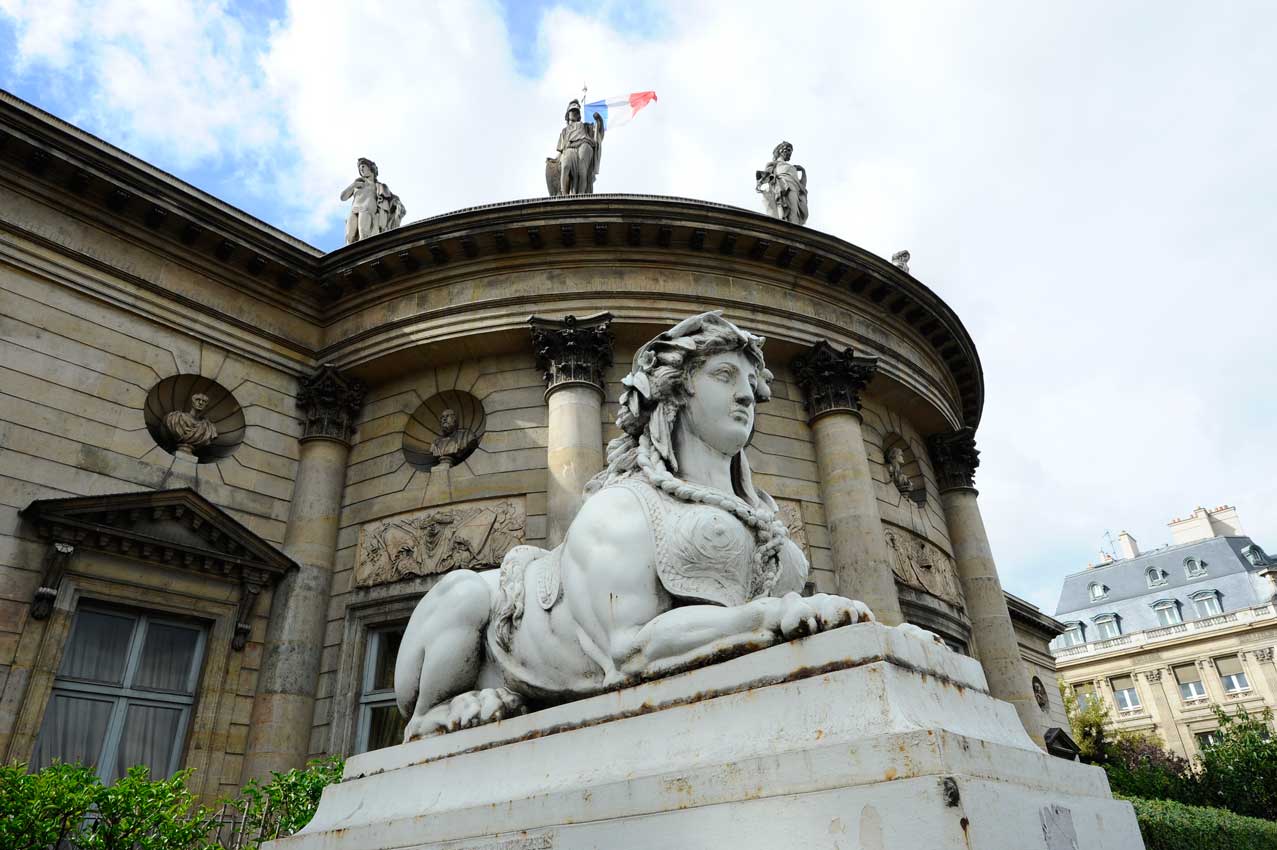


