I remember this from my only visit to Grand Canyon. It was ca. 1950 with my parents and next oldest brother David. This is the North Rim, which is easily determined with a Google Earth visit to the North Rim dead end on Highway 67. Actually, the end of the road is quite alive with a big lodge – which I do not remember – and many other structures. The elevation is about 8100 feet, one thousand feet – or so – above the south rim at Grand Canyon Village, which as the condor flies is about ten miles to the left. Driving between the two rims is a long trip. Most visitors choose the lower south rim only. My dad wanted to see them both. The “head” showing here is about one-and-one-half miles distant and about 100 feet lower than the lodge and, we presume, Horace Sykes prospect. (Click to Enlarge)
In the grand watershed that feeds the Grand Canyon of the Colorado River there is a Little Colorado River that reaches the big canyon thru a canyon of its own with sheer sides and a narrow width that one might imagine flying over in an aerodynamic motorcycle. There are signs warning responsible adults to keep impetuous children and pets away as one approaches this gash in the Arizona desert, for without the signs there is often no sense that there is a canyon until you reach the very edge of it. Persons suffering from Vertigo will want to stay in some Flagstaff Motel. The Little Colorado River comes out of that part of New Mexico that does not resemble Mars, which is the western part at its belt-line. There are forests, lakes and mountains and this Little Colorado comes to life in them and flows northwest thru serpentine wiggles until it approaches the Arizona border, where it starts to move more earnestly in the direction of the Grand Canyon. I found the Little Colorado while using Google Earth to look down from space upon artist James Turrell’s Roden Crater, which over decades he had been arranging with tunnels and other reclamations into a natural light show. Jean, who is one of the rare ones who have visited it on the ground, gave me the directions. It was during my own inspection from space that I noticed that Roden Crater was but a few stones throws from the Little Colorado, and what is more only three miles due west from its Grand Falls. Here I request that the reader open Google Earth and find the place. It is 30 miles northeast of Flagstaff New Mexico. The falls are represented-pictured with several citizen snapshots. And it is easy to find Roden Crater as well although it is not named it is the only crater in a small field of them that shows a path leading into it and a man-made earth-work in it as well. It a downright surreal with a 2001 uncanny caste. The Grand Falls of the Little Colorado River are grand, or can be when the river is swelling, which in this arid landscape is not often. The occasional flash flood makes them spectacular. The falls are roughly 150 feet high and 500 feet wide, and there is one big step included that is about 70 feet wide. By comparison Niagara Falls is about 170 feet high and it falls without a step. Through its sections Niagara is about 3000 feet wide. It is also much wetter and whiter. The Arizona landscape thereabouts often has a red caste to it, and when these Grand Falls on the Little Colorado get splashing the coloring resembles a shake made from a mix of Pepto-bismol and coffee, a tint familiar to persons with caffeine addictions who are also plagued with bad digestion. I only recently came upon the attached waterfall in the collection of Sykes Kodachrome slides. In my urge to find locations for his subjects I hoped that this might be a detail from the Grand Falls of the Little Colorado River. Now I confess after comparing this look at this waterfall with those on Google Earth of the Grand Falls, well, I think that it is not. Once again we are left clueless by a Sykes’ subject, although not hopelessly so. (Click to Enlarge)
The parallel buttes of #382 have few "family resemblances" with #381, but Sykes does not share with us the name of this family. (Click TWICE to Enlarge)
THEN: The building of tax, license, and gift supported bike paths in the late 1890s catered to a local biking enthusiasm that in 1901, it is estimated, involved ten thousand cyclists in a Seattle of about 100,000 citizens. (Photo courtesy of Michael Maslan) NOW: The combined, for some, claustrophobic and vertiginous effects of Jean Sherrard’s “now” must be endured, for - if we have figured it correctly - by standing at the eastern edge of the I-5 freeway pit where Roanoke Street crosses above it, he is no more than a bicycle pump throw from the prospect taken by the unidentified historical photographer he repeats.
I met Frank Cameron during my first year of contributing this feature to Pacific Northwest, where for the June 6,1982 issue I described him as the “complete cyclist; he rides them, repairs them, and researches them.” Frank was then the bike repairman for Bucky’s Messenger Service, and he had recently published his “Bicycling in Seattle, 1879-1904.”
Frank’s illustrated book provided the first clue – a map – for identifying the accompanying photograph, which Michael Maslan – friend, collector and dealer in historical photographs and ephemera – shared with me then. Anders Wilse’s 1900 map of Seattle’s bike paths indicates the “divide” where the 10-mile long path to Lake Washington heads east around the north end of Capitol Hill on its way to the big lake. The map also marks that point of departure as featuring a helpful “guide board.”
Most likely that is the half-way turn sign showing in our “then.” Although with inhibiting directions, Jean Sherrard’s signs are very close to the mark for a proper contemporary repeat where Roanoke Street heads east from Boyston Avenue first bridging Interstate-5 with an overpass. More evidence for this conclusion is included in a 1953 Seattle Time’s feature researched and written by Lucile McDonald, for decades this newspaper’s prolific heritage reporter.
McDonald quoted George Cotterill, the assistant City Engineer who directed the construction of the bike paths first in 1897, as having followed north along the east side of an as yet undeveloped Boylston Avenue as far as Roanoke Street. From there the future Seattle mayor turned the cinder path east to the “great gullies and gorges indented into the northeast slope of Capitol Hill.” When the local “bike craze” soon segued into a “motorcar madness” that section of the cinder bike path was developed into and survives as Interlaken Avenue.”
WEB EXTRAS
Anything to add, Paul?
Shirley Jean. A few illustrated feature’s from past Pacifics – stories that stay near the bike path to Lake Washington. First we will show off George Cotterill, the progressive engineer-politician who took charge of building the bike trails – and much more. George is in substantial profile, right of center and in an opened dark suit with a white shirt showing.
Here follows another look at the split in the path – near Roanoke. This was photographed by A. Wilse sometime before he returned for good to Norway in 1900. It is not such a good photograph, which suggests that it is a generation or two down the line from Wilse’s normally sharp recordings.
Next a 1905-6 look at the Roanoke neighborhood – from Queen Anne Hill.
This you might wish to click TWICE to enlarge. You will note on the far shore an imposing classical revival mansion, one we will soon examine up close. It still stands at the northeast corner of Harvard Ave. and Edgar Street. Also far right is the then new Seward School’s second plant. (We include a thumbnail history of it below.) The “Wallingford peninsula” is on the far left, as yet without the 1907 Gas Works. Note the undeveloped and irregular shoreline across the lake. The Latona Bridge is there – it is still about fifteen years before the University Bridge was constructed, and when this scene was recorded the University District was still as likely to be called University Station (after the trolley), or even Brooklyn, the name chosen for it by its developer in the late 1880s.
The mansion on Harvard at Edgar stands here above the subject’s center. This is part of a 1910 panorama taken, again, from Queen Anne Hill. Roanoke Street is on the right. Nearly clear-cut, Laurelhurst shows a few tall firs kept – for some reason – far left.
A wider 1964 recording of the neighborhood includes Seward school about one-fourth of the way in from the left border. The I-5 freeway is still under construction. (Again, you may wish to DOUBLE click this for a better study.)
Next is a montage that confesses how Jean and I discussed how to proceed with his “repeat” photo. The parts of this paste-up include a portion of the map made of the bike path when it was new, a reduced copy of the primary “then,” and a grab from Google Earth.
As it developed we decided to take the “now” not from Edgar – where the red arrow points – but rather from Roanoke.
Now we will visit a Golden Potlatch party on the lawn of the Ann and Edgar Webster home, which was north of (yes) Edgar in the block between Harvard and Boylston and so now in the air over the south approach to the Lake Washington Ship Canal Bridge on I-5.
On the afternoon of July 17, 1911, Ann and Edgar Webster hosted a Golden Potlatch party for more than 500 guests on their sprawling lawn, which is now - we like to repeat - “in the carbonated air” suspended above the south approach to the Lake Washington Ship Canal Bridge on Interstate-5. The Edgar Street block between Boylston and Harvard Avenues (also now only imagined) was "decorated" with the parked touring cars of potlatch dignitaries. The Parsons Mansion across Harvard Avenue appears upper-right.
POTLATCH PARTY
(First appeared in Pacific, June 3, 1990.) The above scene of a line of Luxury motor cars parked in front of an expansive Capitol Hill lawn appears near the front of a thick photo album recently discovered by a local collector, Michael Maslan. The wide lawn belonged to Edgar and Ann Webster, and so did the album, full of scenes from the city’s summer festival in 1911, the Golden Potlatch.
Most likely the album was a gift from the potlatch organizers, for the 51-year-old Edgar Webster was elected King Edgar d’Oro of the week-long festival. The affable Edgar was an appropriate choice for an event that celebrated the city’s rise over the territory of Alaska. Edgar Webster was New York Life Insurance’s general agent for Alaska and the Yukon Territory, and part owner of the Washington-Alaska Bank in Fairbanks.
The festival’s first grand event was a Saturday, July 17, motorcade led first through the streets of Seattle and then over the city’s new boulevards to King Edgar’s mansion at, appropriately, 704 Edgar St. Although this scene does not include the Websters’ oversized home, which is out of frame to the left, you can see, on the far right, the stately neoclassical home of his brother-in-law, William Hinkley Parsons. Ella Parsons helped her sister-in-law Ann Webster serve tea or punch with ice cream and cake to the more than 500 parading dignitaries.
The society page of the Sunday Times reviewed the occasion as “An ideal summer afternoon, with the surroundings most ‘conducive to comfort . .. A veritable picture was presented on the velvety lawn, with the tea tables arranged under the trees in little bowers formed of hedges of sweet peas and lilies. A touch of color was given the animated scene by the beautiful summer gowns worn by the ladies. A stringed orchestra, screened from view on the wide veranda, discoursed a program of delightful music.”
Follows next something on Webster’s relatives and neighbors across Harvard Avenue.
This is the Parsons mansion that we have pointed out more than once above in the photographs taken across the lake from Queen Anne Hill. (Compliments of MOHAI).
The PARSON’S MANSION on HARVARD
(First appeared in Pacific on July 8, 1990.) By any criterion the Harvard Mansion is a landmark, and its present owners are attempting to formalize that designation. Its monumental Greek Revival portico looks west over Interstate 5 south of the Lake Washington Ship Canal Bridge and two blocks north of I-5’ Roanoke Street overpass. This showplace was designed and built in 1903 by Edward Duhamel for his use.
The Parsons home in 1990 - long after they had left it.
Ella and William Parsons purchased the home in 1909 and within a year added its Colonial-style railing around the second-story deck. Soon after, the family posed in front. (For the now scene – which is typically in deep storage – the Parsons’ grandson, Allen Engle, of Edmonds, shared the scene with the home’s owners in 1990, Randy Apsel and Olga Bourlin, in the course of their research for the landmark application.)
The Parsons mansion, 1968.
William Parsons retired from Seattle First National Bank in 1934. The following year the family moved to Washington Park, and for six years the expensive mansion stood vacant. Since it was again occupied in 1941, the Harvard Mansion has changed hands five times until last year (1989), when the present owners moved in and started their restoration and research project.
The energy given by local cyclists to funding and building the city’s bike paths developed into the Good Roads movement, which ultimately replaced bikes and exercise with motorcars and speed while sitting. The local cycle clubs were often ambitious in their group excursions. Below is a portrait of club members draped about the large Kent landmark that was their destination. In 1896 it would still be four years before the first automobile arrived in Seattle.
Another Puget Sound cycle club pose follows, although where I have no clue.
Three maps now. First the local bike path map, drawn by the photographer A. Wilse. Following that a composite of the maps from the federal survey hereabouts that was interrupted by the 1856 war between some of the settlers and some of the Salish tribes. Like the surveyor’s map the third map that follows it is early enough to name the lake “Union Lake.” It shows a few of the original donations claims at the south end of the lake – however you wish to arrange its name.
Next an early recording of the “east shore” of Lake Union – one, most likely, looking southeast across the passage between the lake proper and Portage Bay.
Identified as a scene on the east shore of Lake Union, the narrow passage in the above snapshot from 1887 suggests that it was recorded from somewhere near the west side of the University Bridge. For the “now” I photographed the “east side” of Lake Union from its north shore in the old Latona neighborhood near the foot of Fourth Avenue Northeast and within the bouquet of Ivar’s Salmon House.
“EAST SIDE OF LAKE UNION, 1887”
(First published in Pacific on May 27, 2007) For the first time in a quarter-century of writing this little weekly feature I am, I admit, tempted to not include a “now” photograph to repeat the historical scene. In the original Lowman family photo album from which it is lifted, the roughly 3-by-4-inch print is clearly titled, “East side Lake Union, 1887.” We may have a general confidence in the caption, for there are many other photographs in the album that are accurately described. With this caption, however, we are left asking, “But where on the east side?”
The earliest photographs of Lake Union are a few panoramas taken from the since-razed Denny Hill in the mid-1880s. None of those, however, helps identify this extremely rare detail of the lakeshore from such an early date as 1887. We can see that there has been some clearing of the forest back from the far shoreline, and in the immediate foreground a sawed-off stump nestles near a still-standing cedar.
It was 1887 when the Seattle Lakeshore and Eastern Railroad was laid along the north shore of this lake through the future neighborhoods of Fremont, Edgewater (near Stone Way) Wallingford/Latona and the University District. Perhaps the photographer hitched a ride on the railroad and took this snapshot looking southeast from near the little park that is now at the foot of Fourth Avenue Northeast, just west of Ivar’s Salmon House.
This conjecture may also help account for how, in the 1887 scene, the shoreline draws closer to the photographer on the left side of the cedar. Historical maps of the undeveloped east shoreline of Lake Union show such an irregularity near where the Interstate 5 freeway bridge sinks its piers on the east shore of the lake. And so we feel somewhat confident that the right prospect has been found for the repeat.
********
Next we turn to take the fork to the right and head for Lake Washington. Some of our stops will be known, other path photos will be introduced, which we hope were taken on the part of the path system that led to Leschi.
ADELPHIA HALL
(First published in Pacific, on June 23, 1991.) Throughout the 1990s, expect a proliferation of centennials in Seattle. It is a century since this city began its big boom in population and institutions. This year Seattle Preparatory School and Seattle University, both Jesuit institutions, celebrate together.
In 1891 the Jesuits took over St. Francis School, founded in the late 1880s by Seattle’s first Roman Catholic priest, the Rev. F. X. Prefontaine. Soon the order moved to the present site of Seattle University. When the institution moved again in 1919 to the north end of Capitol Hill, it was a combined college and high school.
These, however, are not Catholics in this early view of the school’s Adelphia Hall but Swedish Baptists. Built in 1906 to train Baptist missionaries for Asia, Adelphia College operated until 1917, when World War I depleted the supply of male students. The site was then purchased for the Jesuits by a Catholic couple, Thomas and Elle McHugh, who lived on Capitol Hill.
After Seattle College returned to its Broadway site in 1931, Seattle Prep was left to develop this Interlaken campus. A gym had been added in 1929 and after the 1949 earthquake shook the institution’s foundations, the austere, modern South Wing (Seen on the right of the contemporary scene – if we had found and included it.) was built between the original hall and the gym. Old Adelphia Hall’s roof was removed after the 1965 quake weakened its timbers, and in 1982 its facade was hidden behind the new McHugh Gymnasium.
Earlier, in 1975, Seattle University and Seattle Preparatory School were united again in Matteo Ricci College, a program (with lots of home work) that graduates a high-school freshman from college in six years.
Looking up at Adelphi Hall from what? This is the route of the Bike Path to Lake Washington, but it appears to be here in the process of being graded for motorcars. This seems likely because the hall was constructed in 1906, several years after the bike path was first put through.
We continue a little distance to a prospect that allows one to look due north into the University District, aka then as Brooklyn.
BIKE PATH PANORAMA
(First appeared in Pacific on Jan. 18, 1999.) This is one of the few easily identifiable scenes recorded a century ago by Seattle photographer J.F. Soule along the Lake Washington Bicycle path. Its view looks due north across Portage Bay in line with the University District’s 12th Avenue. This is also the earliest panorama of the Brooklyn neighborhood, as it was more commonly called in the late 1890s.
The cinder path between downtown Seattle and Leschi Park was opened June 19, 1897. The point was not to get to Lake Washington quickly, but athletically. So the trail -built by the Queen City Cycle Club before there were any motorcars in Seattle -wound around the north end of Capitol Hill. After 10 miles the cyclists reached Leschi Heights. And they did it with one gear.
This path is well marked with bike tracks. Although built 6 feet wide, the lane has been narrowed by encroaching weeds, and the little sign at the bend gives prudent advice: “GO SLOW / RING BELL / KEEP TO THE RIGHT.”
Interlaken Boulevard was developed out of the bike path and the contemporary view (after we find it) was photographed within a few feet of the position taken by Soule for his North-End panorama. This section of the boulevard is just below Seattle Preparatory School.
Most of Soule’s bike-path photographs have been copied and appear in many libraries and museums. This copy, however, was made from one of 15 original prints -perhaps Soule’s complete set – in private but still helpful hands. (Courtesy Michael Masland and Mike Fairley.)
This stump with two boys and Portage Bay behind them (with a glimpse too of Montlake too) may be compared to the stump in the photo above it. (Courtesy Michael Maslan)A scene along the path - probably the path to Lake Washington.And another.
GOOD ROADS LUNCH & HALF-WAY STOP
(First appeared in Pacific, Dec.16, 1990.) The rustic charm of the Good Roads Lunch Room was enjoyed by tired bicyclists pedaling the miles of cinder path that twisted along the wooded ravines at the north end of Capitol Hill. This sandwich shack was the 1897 creation of the Queen City Good Roads Club, an organization of bike activists who also built the cinder trail between Lake Union and Madison Park.
Determining the exact location of this halfway house, as it was called, required some speculation. George Cotterill, the assistant city engineer (and future mayor) who helped the bikers build their Lake Washington trail, said it was set in one of the two
largest canyons between Roanoke Street and 23rd Avenue, the part of the bike trail that is now Interlaken Boulevard. A crude “Guide Map to Bicycle Paths,” published in 1900, places the lunch stop near where the then-proposed trail to Volunteer Park (now Interlaken Drive) was to meet the Lake Washington bike path.
Some of the signage in this detail of the Good Road half way house can be made out - or nearly. There is a sign for Lemonade, another for Milk Shakes (well, the "Milk" is easier to read that the "Shakes") and three prices are indicated on a blackboard at the door: 10 cents, 20 cents and 5 cents, although I cannot make out what they will purchase.
Given these hints, it seems likely that the Good Roads Lunch Room was at the curved apex of the large ravine just east of where Interlaken Drive now meets Interlaken Boulevard. Of Cotterill’s two big canyons, the eastern ravine is much closer to Interlaken Drive, which climbs the ridge just above it.
The Good Roads Lunch Room was as short-lived as the cinder trail and the early bike craze. In 1905 Interlaken Drive and the eastern half of Interlaken Boulevard that extended from the “Y” to 23rd Avenue -the part that included the Lunch Room site – was widened and converted into a boulevard for motorcars. In 1908 the other (western) half of Interlaken Boulevard, between the “Y” and Roanoke Street, also was included in the city’s growing boulevard system.
FOREST RIDGE
(This first appeared in Pacific on Jan. 24, 1993.) The Society of the Sacred Heart of Jesus opened its first school for girls in Seattle in an oversized Capitol Hill home in 1907. Its stay was short-lived when anxious neighbors objected to the sisters’ plans to expand. So the school, which was also a convent, moved further north to a spectacular sight 300 feet above Portage Bay, where this brick and sandstone landmark was speedily built and dedicated in 1910. The name Forest Ridge was adopted to avoid confusing the new institution with the local Orphanage of the Sacred Heart.
In his history of Forest Ridge, Seattle historian David Buerge relates how the school’s layout was snipped with scissors from the floor plan of another of the order’s schools, Barat College in Lake Forest, Ill. The collage was handed to Seattle architect F. A. Perkins, who fit it into this neo-classical construction.
Low resolution likeness - Barat College with its own caption grabed of the net.
The first 63 students began classes two weeks late when the school’s furniture was slow to arrive. The day students came mostly from surrounding neighborhoods; the boarders came from everywhere in the Northwest. Enrollment reached 160 in 1927, but crashed during the depression to only 54. Enrollment rose steadily after World War II, reaching 340 pupils in 1958. Thirteen years later, the Forest Ridge school moved out and up 500 feet to Bellevue’s Somerset Hill, 800 feet above Lake Washington, where this year 242 students are enrolled in grades 5 through 12.
Since 1972 the order’s old plant on Interlaken Boulevard has been the home of the Seattle Hebrew Academy where, this year (1993), 263 primary-level pupils study a curriculum of general and Judaic studies.
ALONG THE BIKE PATH ABOVE LESCHI
For a few exhilarating years around the tum of the century, bike riding was a popular craze in Seattle, and the building of bike trails around its hills an ingenious engineering trick. Those were the early pre-gear years of bicycling.
When a writer for Sports Afield visited Seattle in 1897 and tested the new bike trail to Lake Washington, the weekly Argus repeated for the locals the sophisticate’s belief that “had the old Roman road builders dropped into Seattle this spring, they would have been heartily surprised and doffed their hats to the wheelmen who can lead a six-foot path through virgin forests, in and out of a terribly rough country, along the sides of exceedingly steep hills. When completed, the grades will be few and all easy for even a novice to ride.”
Here above is, perhaps, one of those novices on a part of that path. And the photo does a good job of showing both the easy grade and that “terrible rough country.” Its distant view also reveals why the Argus editor dared to draw a moral from the national arbiter’s remarks. “I do not care who the critic is or how many wonderful sights he had seen . . . he cannot pass over the Lake Washington path . . .without being impressed with the magnificent panorama revealed at every tum on this snake-like path.”
But which tum in the snake is this? As often as I have seen this popular photograph in exhibits and publications none of them, including the excellent short history Bicycling in Seattle, 1897-1904 by Seattle’s bicycle authority Frank Cameron, has pinned it down. So 1 first went searching for Frank Cameron and a caption for this photo more precise than the usual generality “along the bike path.” And 1 found that the one-time master mechanic for Bucky’s bike delivery service was now (in 1986) “repairing” or moving humans with his new duties at Traveler’s Aid. Frank and I put our heads together, switched a few gears and soon determined that this view rather quickly gives itself away.
As surely as a fingerprint, the profile of the horizon and the shape of the shoreline identifies the first land across the water as Mercer Island. And more precisely, that is Mercer Island as seen from what was then called Leschi Heights. So this is near the Leschi Park end of the Lake Washington Bike Trail and more than ten wild but relatively level cinder-surfaced snaking miles out from the city center. Frank also remembered from his research that it was here that the cyclists who did not tum around faced a fork in the road, and both ways were steep. The one descended to the amusements at Leschi Park and the other to the top of Leschi Heights. The trail’s split at the photo’s lower left comer may be that fork.
The Argus editor, concluded that this was a “wheelman’s paradise” where “lost in the forest . . . among the birds that spring from twig to twig . . . he drinks in pure air and thanks God for the power which enables him to appreciate nature.” Frank Cameron adds that in 1901 warnings were issued on Capitol Hill about bears frightening bicyclists on the Lake Washington Bike Path.
Much of the old and short-lived bicycle path was eventually transformed into city streets – notably the scenic Interlaken Blvd. that still winds through the woods at the north end of Capitol Hill.
LESCHI LEISURE
(First appeared in Pacific June 10, 2001.) The Topography of Seattle, our picturesque ridges and waterways, has predisposed us to exercise. We may not make a habit of climbing Queen Anne Hill, but if we live on it or any of the 37 or so other hills and hillocks hereabouts, even the most sedentary among us may well have to huff-and-puff to our own front door. That, too, counts as exercise.
But what of reclining in a canoe? Here on the Leschi waterfront nearly a century ago is a crowd that surely delights in itself. Whether pausing on the promenade, sitting on the bulkhead or resting in a canoe, these are mostly young people who otherwise might have been stretching.
Did they, by the end of this day, say in the summer of 1906, also feel the great satisfaction of endorphins got from paddling across the lake? Or the lingering excitement of stretched sinews from biking back to town?
At the east end of the old Indian trail between Pioneer Square and Lake Washington, Leschi quickly developed into one of Seattle’s first pleasure gardens, especially after the electric trolley was completed along that same trail in 1888. Nine years later it was possible to pedal to Leschi very indirectly on a trail around the north end of Capitol Hill, and for about a dozen years biking kept its popularity. Despite vast quantities of lard and sugar consumed, we were in 1900 perhaps as fit a city as we have ever been. The convenience of the motorcar increasingly softened muscle tone.
Today at Leschi the descendants of this lakeside society have moved down a ramp to the locked dock where they keep their sailboats. For a scene as snug and exercise-driven as this it is now best to look through the great plate-glass windows of our many exhibiting health clubs.
The Leschi Park Pavilion, home for theatre, concerts - and beer.
Next we will return to surviving landmarks – a school and an apartment building – that are near the fork in the path at – or near – Boylston and Roanoke.
The second Seward schoolhouse looks down and west over Rogers Playfield towards Lake Union.
SEWARD SCHOOL
(First appeared in Pacific on May Day, 1994.) All three of Seward school’s historic structures survive and are used side-by-side. What’s still called the “new” plant was built in 1917. This slender brick structure looks over Boylston Avenue East to Interstate 5. South of it facing East Louisa Street nestles Seward’s oldest building. Built in the sticks of north Capitol Hill in 1893, it was first named Denny-Furhman School for the families that owned most of the land around the school.
A second eight-room structure was added in 1905 when enthusiasm for things Alaskan was a local obsession. Consequently the school board renamed the school after William Henry Seward, the secretary of state who in 1867 arranged the purchase of Alaska from Russia. The charming architecture of the second schoolhouse is the centerpiece of this week’s comparison. (First published May 1, 1994, the “now” has gone hiding.)
The 1917 addition of the large brick plant now behind it diminished the elegant impression this structure made on those passing below on Eastlake Avenue East. However, in the early 1960s when 1-5 bisected the neighborhood the “new” brick building served as a sound buffer for the older frame school house behind it. By 1970 practically all classes – except the already noisy music class – abandoned the brick plant for the relative peace of this timbered school house.
In the inid-’70s, parents defeated the school board’s attempts to close the school. Since 1990 Seward has been the home of TOPS, an alternative program that emphasizes innovative teaching techniques and parent involvement. Perhaps some of TOPS’ 400-plus students will eventually be numbered among Seward’s distinguished alumni, along with Pearl Wanamaker, former state superintendent of public instruction; Pulitzer Prize winner Edwin Guthman; and molecular geneticist Dr. Henry Erlich.
When new in 1909, the L’Amourita apartments at the northwest corner of Franklin Avenue and Shelby Street were a unique Northwest example of East Coast townhouse living built in a Southwest style. The L’Amourita has been a cooperative since the 1950s.
L’AMOURITA,
(First appeared in Pacific March 3, 2002) L’Amourita, the Spanish Colonial apartment named for lovers, was a half-century old when its tranquility was first interrupted in 1959 by construction of the Lake Washington Ship Canal Bridge above it. The bridge was completed in the fall of 1961, and tenants in the 21 units at L’Amourita would have a year’s hiatus from the noise before that first Seattle section of Interstate 5 opened to traffic.
Residents have mostly gotten used to the clatter, especially from the express lanes, that manages to break in. Grace Hitchman has lived in one of the apartments for 23 years and has slept soundly except when the traffic stops. Then she wakes up. Since the 1950s, the building has been a cooperative run by a board of tenants. Over the years, the story of its origins has several versions. Costi Parvulescu, a member of the co-op’s board, shared one: “The story goes that a Portuguese farmer built L’ Amourita and kept adding sections as he got more daughters.”
This has a grain of truth. An investments speculator named Adolph J. Jarmuth built L’ Amourita whole-piece and lived with his family in its first apartment at the corner of Franklin Avenue and Shelby Street for the first two years only. In the beginning there were only eight apartments, described in The Seattle Times then as “divided by concrete walls and having from seven to nine rooms.” The building, said The Times, was “the first of its kind in Seattle.”
With exterior concrete walls 22 inches thick, L’ Amourita was built nearly for eternity. “I think most of Seattle has lived here at one point,” says present board president Lysa Hansen.
The PONTIUS MANSION
(First appeared in Pacific on Feb. 5, 1995) Soon after Rezin Pontius’1865 arrival in Seattle, he sent for his wife Margaret and son Frank, who followed him from Ohio by way of the Isthmus of Panama. The family grew in numbers and wealth – five children and much land. Then suddenly Rezin fled his family and fortune. He left unannounced and his wife, who never mentioned his name again, did not learn of his destination – California – until years later when Rezin contacted his sons.
Margaret Pontius, who was described as sometimes darkening her great charm with the shadow of a bad temper, was quite capable of making do without him. The family fortune grew, for the Pontius homestead in the future Cascade neighborhood between Denny Way and Lake Union was in the path of a Seattle expansion that exploded after the city’s “Great Fire” of 1889. That year Margaret built her mansion.
The architect, John Parkinson, is described by Jeffrey Ochsner in the University Press book “Shaping Seattle Architecture” as a “major Seattle designer” in the years following the ’89 fire. Later Parkinson continued his distinguished career in Los Angeles. Parkinson chose the then-popular Queen Anne style for Margaret Pontius. Margaret lived in her mansion at Denny Way and Yale Avenue until her death in 1902. Rezin, who had returned to live with his oldest son Frank in Bothell, died 16 years later.
In 1905 Margaret Pontius’ children rented the mansion to the Mother Ryther Home for orphans. It served as an orphanage until 1919, when the Rythers moved to larger quarters in Wallingford. (Since 1958 the Ryther Child Center has been located at 2400 N.E. 95th St.) The landmark Pontius mansion survived until 1930, when it was replaced by a garage for the North Coast Transportation Company, a predecessor here of the Greyhound Line.
REPUBLICAN HILL CLIMB
(First appeared in Pacific on Oct. 14, 1984.) Included on our imagined list of lost places is the Republican Hill Climb. This elegant stairway was designed to reach higher than the hill. Its grand qualities were meant to be enjoyed for their own sake. And for half-a-century they were. The climb’s design involved three half-block sections. Each was comprised of two single stairways and one double, or branching staircase that circumvented a curving wall.
This view looks east from Eastlake Ave. N. The two men in the scene have apparently chosen to take the northern side of the hill climb’s first set of branching stairs. They might then have continued on another half block to Melrose Ave., which is just beyond the second curving wall. The very top of the steps is a half block beyond that, and, on the horizon, a third wall that marks it can be seen, barely, just above the second wall. (This top one-third of the Republican Hill Climb is still intact and in use.)
The Republican Hill Climb was approved “as built” by the Board of Public Works on February 25, 1910. This photograph was probably taken soon after that. The landscaping here is still nascent. Fifty years later, the Times published a different photo (not included here). It reveals that in its last days this Republican Hill Climb was pleasantly crowded by tall trees and bushes. The Times caption stated simply, “This stairway will be torn out when the freeway grading begins.”
Of course, that “dream road” not only ended the steps from Eastlake but also sacrificed a very invigorating connection between two neighborhoods, Cascade below and Capitol Hill above. But, as City Engineer R. W. Finke explained in 1952, soon after this freeway route was proposed, “Freeway traffic moves at relatively high speed without interference from cross-movements…Pedestrians, who are a constant hazard to city driving, are entirely removed.” Pedestrians and much else.
Frank Shaw looks south thru construction on the Seattle Freeway (I-5) north of Denny Way. Shaw dated his slide May 30, 1962. I remember well the apartment building facing Eastlake Ave. on the far right. It was, at least, near Republican.
Above and below: four women – in all – on two bike paths. I have not determined where the above photo was recorded, however the curving rail on the far right is a fine clue. That and the lay of the land. Perhaps a reader . . . .
The scene below, like the freeway construction shot above, is by Frank Shaw, but twenty two years later in 1984. Here the bike path is the lower express level of the Lake Washington Ship Canal Bridge, which has on occasion been closed for the sport of cyclists and joggers. Why there are only two here is puzzling.
We have expectations of more features for these bikeways – if they come together pretty much on their own and a little help from a few friends.
Yellowstone surely, but perhaps not Old Faithfull. The most common view of Old Faithfull shows a different horizon line than this. How quaint of Horace to photogaph the geyser between eruptons.
Some of Syke’s slide, like this one, came to a surreal condition by reason of some chemistry along the way. The blue is too blue, and the focus soft. What to say about the rusting landscape? But note the monolith centered on the far horizon. Did Horace mean to stage it all around that isolate effect? When grabbed in detail, like below, some of these rougher slides appear like gouache canvases. (Click to Enlarge)
These two subjects fit at the top by coincidence. Still they seem to be related in other ways – or yearn to. I found them in the same Sykes box, but there were many other slides as well that did not share whatever it is that these two show together. The odd colors, for one: the blue. How much of that is Kodachrome? The upper corners of both slides show what we are used to with many cameras: an inefficiency of the lens to expose the sky consistently. It gets considerably darker in the corners. Comparing the two slides may invoke feelings of the uncanny, which is that something that is dead is acting alive. Or better that something that is steadfast is about to come unglued. It is a puzzle. How close were Syke’s prospects for these two? Is there, for instance, a missing slide that might create a merging panorama? Typical for Horace, the location is not revealed. Perhaps in some distant blog exploration someone will stumble on these rocks and recognize them in an instant. That may be as likely as finding another Tut in another desert. (Click TWICE to Enlarge)
I like the composition of this Sykes. Here’s a band of natural parts layered like lasagna high from another Horace Golden Tree at the bottom. The massing is democratic with the four banded and imbricating parts taking nearly equal shares of the composition. This is merely descriptive, and not meant to offend either royalists or tyrants. The parts could be unbalanced in another composition to effects and pleasures of their own. I am reminded of Prof. Yates and a college class in aesthetics. Yates was very angular, a thin man and tall enough to regularly bump his head into a lamp hanging from the ceiling of his classroom near a window he liked to open wide for deep breathing. He was made in central casting for the part of absent minded professor and wore his tweed well. For the course he chose a prescriptive history in a thin volume that after considering a variety of historical approaches to “art and beauty” came to its own conclusion, that both had to do with “perceptual relations,” the play between the parts of what we perceive. It was not a very emotive approach, this “perceptual relations.” Or I might have also titled this composition “sturm und drang,” which is, many readers will know, a romantic period in German cultural history that I learned first down the hall from Yates room in Dr.Simpson’s class in world literature. Really it was a class in Western – not World – literature. (Click Twice to Enlarge)
In 1393, Louis d’Orléans Charles V’s second son built a fortified residence to keep an eye on trade between Flanders and Burgundy, fifedoms of Dukes of Burgundy, his rivals.
In 1616, the castle was dismantled after a fatal siege led by king Louis XIII. The ruins were forgotten until the XIX century, when Napoléon I bought it in 1810, and then in 1857 Napoleon III entrusted the restoration work of the castle to the architect Viollet-Le-Duc.
In 1855, Viollet-Le-Duc restored the cathedral Notre-Dame in Paris (photos at the exhibition Now and Then at the MOHAI). The architect applied his doctrine of the Middle Ages to Pierrefonds making it in a genuine innovation : “to restore an edifice is not to maintain it, repair it, or remake it, is to re-establish the monument in a complete state that may never have existed at a given moment.”
Le Moyen-âge selon Viollet-Le-Duc
En 1393, Louis d’Orléans second fils du roi Charles V construit une demeure fortifiée près de la forêt de Compiègne au nord de Paris pour surveiller les échanges entre les Flandres et la Bourgogne fiefs des ducs de Bourgogne ses rivaux .
En 1616, le château est démantelé après le siège de Louis XIII, et tombe dans l’oubli.
Au XIXème siècle, les ruines romantiques retrouvent de l’intérêt, Napoléon 1er achète Pierrefonds en 1810, et Napoléon III confiera en 1857 la restauration à l’architecte Viollet le Duc.
En 1855, Viollet-Le-Duc restaure Notre-Dame (photos à l’exposition Now and Then au MOHAI), à Pierrefonds site majeur où son talent et sa vision architecturale sont le mieux exprimés , il réinvente le Moyen-âge selon son principe : « restaurer un édifice, ce n’est pas l’entretenir, le réparer, ou le refaire, c’est le rétablir dans un état complet qui peut ne jamais avoir existé à un moment donné ».
The castle before the restoration in 1855
Le chateau avant la restauration de 1855
The castle Now , but not in the same perspective
The Great courtyard is inspired from Renaissance style with the double spiral staircase
Le decor de la cour d’honneur est inspiré de la Renaissance avec son escalier à double révolution
Sometime in the late 1940s the Dorpat family made its first trip from Spokane to Portland in a 1946 Plymouth sedan and stopped to give a devotional study to the sublime Multnomah Falls. (We were on our way to a church-something in Portland.) In 1949, say, these falls were nearly the most exciting roadside attraction along the Columbia. That distinction still held then to Celilo Falls, with the native American fishing platforms and the camps they set up beside them. It was explained to me then - I don't recall by whom - that many of the jalopies strewn about the camp site were broken cars abandoned to the elements, for "the Indians never fix their cars." This seemed wonderfully strange to me at the time, now it seems more like an example of racist half-wittedness. The Dalles dam submerged the falls, the camp sites and whatever motorcars were not dragged or driven to higher ground. My most recent visit to - or past - Multnomah Falls was in 2005, and Jean was driving. We were chasing some "repeats" for our book "Washington Then and Now." As a sign either of being in a hurry or, most likely, our inured sensibility, we scarsely turned our heads to the falls as we sped by on what is now a freeway along the river's Oregon side. Now I wonder if I have posted this subject earlier. It is a another tribute to Horace Sykes that he too in the late 1940s - most likely - felt the need to record these falls in spite of the season. Some last vestiges of the fall's Action Painting survive here in Sykes' setting and the falls themselves are softened in the dim light by his slow shutter. (Click to Enlarge)
Perhaps this is a one of the many deep valleys that roll to the north out of the Wallowa mountains in northeast Oregon - methinks perhaps. But I have not explored this hunch - as yet. (Click to Enlarge)
THEN: This record of the southwest corner of Green Lake is another scene pulled from the large Webster and Stevens collection at the Museum of History and Industry. “W&S” was the contracted photography studio used by The Seattle Times for many years and it is possible that this subject first appeared in this paper a century ago. (Courtesy, MOHAI)NOW: For his contemporary repeat Jean Sherrard has kept close to the lowered lake in order to show the racing shell side of the parks’ – both Green Lake and Woodland – recreational diversity. His subject also includes the surviving section of the Aqua Theatre, which when it was built in 1950 seated 5,500 for big aquatic shows that were a mix of costume theatre, stunt and high diving and synchronized swimming.
This Green Lake tableau looks south over the shoulders of young boys enjoying the eternity of a summer day at the southwest corner of the lake. The likely year is 1908 or perhaps ’09. On the horizon is the nearly new Wallingford sanctuary for St. Benedict parish, which was dedicated in September 1907.
This south end of Green Lake was first reached from Lake Union by a wagon trail in the late 1880s, and soon after by an electric trolley. The streetcars completed their run along the east and north shores of Green Lake on the grade of a logging railroad that had helped clear-cut all the Green Lake neighborhood except this Woodland Park part of it, then still a country retreat for the Guy Phinney family.
Green Lake was lowered seven feet in 1911 in order to create the park that now rings the lake. In Seattle Parks historian Don Sherwood’s hand-written manuscript for Woodland Park it is described as including “the first major playfield, swim beach, boating and fishing facility to come under the jurisdiction of the Park Department.” In the century between this “now and then” the park acres (for both Green Lake and Woodland parks) nearby this scene have also been appointed for track and field, soccer, baseball, golf (the pitch and putt variety), lawn bowling, horseshoes, tennis, soapbox racing, and skateboarding.
An exotic moment with the Green Lake Aqua Follies.
For this southwest corner of the lake the most consequential park development was one that did not happen – here. Despite the vigorous objections of, it seems, most Seattle citizens and this newspaper too, the 1932 extension of the Aurora Speedway (Highway 99) was cut directly through Woodland Park. The alternative would have directed the north-south traffic linked to the Aurora Bridge in a detour along Stone Way and the west shore of Green Lake, and so directly thru this scene.
WEB EXTRAS
Anything to add, Paul?
A few features as time allows, starting with the TEXT for the 1903 panorama of Green Lake as see today from a prospect that looks over the 1-5 Freeway. Jean, you will need to put up the images as illustrations for what follows – put up when you get up in the morning, for a richly deserved slumber after directing the last night of “AS YOU LIKE IT” with your students at Hillside School. Bravo. Perhaps you will write something about taking your repeat for the 1903 pan. For now, I’ll insert a photo of the lumber mill that felled the old grown forest that once surrounded the lake, and a ca. 1890 photo of part of the same East Green Lake neighborhood, and describe these briefly within their captions.
Green Lake Panorama by A.Curtis, 1903. Click to ENLARGE.NOW: Jean's repeat, taken for the exhibit at MOHAI. Jean comments, "This was a tough one, given Curtis' perspective and the modern interference of the freeway. After attempting a couple other locations - one atop the roof of a nearby church - we settled on this view between 71st and 72nd overlooking the mare's nest of exits and entrances to and from I-5."
GREEN LAKE PANORAMA
Hidden, but not lost, in the files of the Green Lake Library are the 16 pages of The Green Lake News: Anniversary Number. On November 26, 1903 the News was one year old and excited at having survived to record and promote the suburb’s “amazing growth.” The anniversary number includes a wide-angle photograph of this booming neighborhood captioned “Birdseye View of Green Lake, taken in 1903.” It is a composite of three negatives photographed – probably on commission from the newspaper – by Asahel Curtis. (Curtis’ 1903 panorama is reproduced here with the middle and right panels merged. If I can find the left – north Wallingford – panel I’ll insert it later.)
In 1903 Green Lake was in the midst of its second spurt. John Martin, one of its boomers, confessed in the pages of the anniversary number, “A little more than three years ago an irrepressible desire for freedom from the ‘noisy traffic of the city forced the writer into a search for a quiet home . . . The attractiveness of Green Lake was irresistible. Then not more than 500 people surrounded it. Now there are nearly 10,000!” Martin was not complaining. Three years earlier he had purchased 20 Green Lake lots.
Martin claimed that this flight to the suburban lake was caused by the congested city, effective advertising (like his own), and what he called the “two-mile charmed circle.” This referred to the liquor-free zone which radiated from the University of Washington and “within which by the grace of the legislature, no saloon can come.”
The Green Lake Mill, which was active in the late 1880s and early 1890s, unless Green Lake historian Louis Fiset corrects me on it. It was set near where the Green Lake Library is today.
The first boom was in the early 1890s when settler-promoters like W. D. Wood, F. A. McDonald, and Guy Phinney bought up big chunks of forest about the lake, cleared and platted some of it, and constructed the Green Lake Circle Railroad Loop around the lake and up from Fremont. The international crash of 1893 stopped the land rush and slowed the trolleys. Phinney’s land is now Woodland Park. We can see its uncut verdure on the far left of the pan. And the ridge that runs across the photograph (just under the snowy Olympics) still bears his name.
A stump puller at work in the early 1890s in what is now the principal Green Lake business district, which is on the northeast side of the lake. Phinney ridge is on the horizon. This image was mostly likely photogreaphed by a Green Lake resident, the teacher called Professor Conn, by some. About a dozen of his neighborhood (including Ravenna Park) views survive.
McDonald’s parcel was to the southeast, much of it now included in Wallingford, Wood’s property covers much of the panorama’s center in east Green Lake. Wood was the visionary (and one-time Seattle mayor) who for years pleaded – to quote him from the Anniversary Issue – that “the Green Lake frontage be secured by the city for park purposes, and that the lake be made a water park upon the plan that has made Minneapolis so famous.”
Wood was convincing. The city soon purchased the lake, and in 1911 lowered it seven feet, thereby exposing hundreds of acres for park use. The largest part of this reclamation was the bay that used to dip into east Green Lake and which is now the large playfield across from the Green Lake shopping district.
The one landmark that survived almost into the present is the Green Lake Public School on the far left of the center panel. It was first opened to students in September of 1903 – or within a few weeks of Curtis’ recording it. The wooden school, closed in 1983 by the fire marshal, was designated a landmark in 1981 by the city’s Landmarks Preservation Board. This did not prevent it from being razed, however, in the summer of 1986. It has been replaced by a modern plant in the same location.
The ca. 1855 federal survey and timber marking map - easily the earliest map of Green Lake, surved with a Gunther Chain and marking section lines.Olmsted plan for a Green Lake Park developed on land exposed and relaimed with the lowering of the lake.Circa 1967 aerial looking west over Interstate Five and Green Lake.
WEST GREEN LAKE WAY
(We may have included the above subject previously in this blog, but without the story below that first appeared in Pacific Mag. on May 1, 1984.)
In the late 1970s Don Sherwood, then a Seattle Park Department employee, organized his department’s historical records. The results of this ambitious project are packed into four 5-foot cabinets in City Hall’s Municipal Library. (This was first published on May Day, 1984. Now once access Sherwood’s papers on the Seattle Park Department’s webpage.) The Green Lake folder is the Sherwood Collection’s thickest file, and the original photographic print for this historical subject is from it.
Many of the homes in the older view survive. Because most are now hidden behind trees, I used the overlapping rooflines of the houses across the lake to locate the original photographer’s shooting site. (I have long since misplaced – but not lost – the 1984 “now” for all this.) Wallingford’s Home of the Good Shepherd is faintly evident right of center and through the limbs of the almost leafless tree which is above and to the left of the touring car. Of course, this car and its riders are not touring but posing. There is no one in the front seat because the driver of the car is probably the photographer. “1911” is lightly penciled on the back of the original print. The year is probably correct and the shedding tree suggests it is fall.
It is certainly not spring. If it were, then this planked viaduct would be over Green Lake, not beside it; those two dark boathouses in the scene’s center would be floating on the lake rather than leaning toward it, and there would be no sandy peninsula intruding into this the southern end of the lake. 1911 was the year Green Lake was lowered seven feet. The lake was lowered at the recommendation of the Olmsted brothers, those famous landscapers who designed much of Seattle’s park system. Although the city owned the lake, only a narrow strip of squeezed land lay between the water and the privately owned streetcar line that nearly circled the lakeshore.
In 1908 the Olmsteds proposed that by lowering and thus shrinking Green Lake, it would become “a lake within a park.” They asked for four feet, and three years later the park department obliged and went three feet more. The lake’s lowering created a park; however, it also provoked decades of “swimmer’s itch,” recurring attacks of anacharis cana densis (a lake weed with a political-sounding name) and clouds of algae. This small lake made smaller did not drain itself well, and so was forced to outfall into the city’s sewers. The irritating “greening of Green Lake” followed with three-quarters-of-a-century of emergency studies, chlorinations, dredgings, and lake closings. Swimmers are still scratching.
The 1908 Olmsted report also recommended that a “pleasure drive run south along the shore of Woodland Park by easy curves.” The pile bridge pictured here was the city’s first response. The city council approved its plans on March 8, 1909. The plans (and the photograph in part) show three rows of pilings supporting a roadway of 4″ x 12″ planks, sided by three-foot railings made from 4 ” x 4 ” posts and 2″ x 6 ” top and side rails.
Once stranded with the lake’s lowering, this picturesque pile bridge’s future was insecure. On October 14, 1914, the city council approved another “plan of improvement” for West Green Lake Way. Within a year the bridge was gone and replaced with a paved boulevard that sill keeps to the grade and line of Green Lake Way.
********
GREEN LAKE EAST SHORE – 1913
The city’s early-century regarding mania smoothed many of its downtown streets, and it also reached the shores of its lakes. It was so politically fashionable to propose large-mannered public works that in 1909 City Councilman Hiram Gill, fresh from a nearly finished-off Denny Hill (as far east as 5th Avenue), proposed cutting the top off Queen Anne Hill and filling in most of Lake Union.
Fortunately, when Gill later won the mayor’s race, he was distracted from the project by “regrading” the city’s ethics and opening it up to the good-paying pleasures of gambling, booze and bawdy services. While Lake Union was spared having the city’s highest hill dumped into it, Green Lake was subjected to a less drastic alteration – a kind of manicuring of its rough natural cuticles.
Park building along the east shore of Green Lake looking north to the - marked - Green Lake Public Liberary.
The Olmsted Brothers, those visionary landscape architects, proposed buying up the shoreline around Green Lake, lowering the lake, then landscaping the perimeter as a park. Over a period of years, the city did just that. Showing in this 1913 scene is the intermediate mess between the old and new lake looking north along the eastern shore. The fine-tuning of Green Lake’s shoreline continued until 1933. The final fill dirt was dumped at the south end of the lake in 1932. The soil was grabbed during the cutting of Aurora Avenue through Woodland Park.
******
More than twenty years of work went into shaping Green Lake’s new shoreline and with it the enlarging of Green Lake Park. The East Green Lake Playfield, shown in part here twice, was the largest addition of park land made from fill piled on top of the old lakebed. The view looks north along the curving western border of that fill. I recorded the “now” for use in Pacific in 2005. It is at the bottom of this cluster. Jean took another for our “REPEAT PHOTOGRAPHY” that is now on exhibit at MOHAI – for another year, so take your time. Historical pic. courtesy of Paul G. Pearson
OLMSTED CURVES on the EAST GREEN LAKE ELEVATED
Thanks to Paul G. Pearson who sent along this week’s revelation of how a new shoreline was constructed for Green Lake, and with it the gift of a new city park.
This view of a pile driver constructing its own throughway across the East Green Lake Bay was photographed in 1912. One year earlier the lake was lowered seven feet with mixed results. It robbed the lake of its natural circulation by drying up the stream that ran between the Lake and Union Bay on Lake Washington. (Decades of “Green Lake Itch” would follow.) But it also exposed a shoreline that was the first ground for the new park that was extended with fill.
The pile driver is following the curves of the Olmsted Bros. 1908 design for Green Lake Park. Following the driver a narrow gauge railroad track was laid atop the trestle and by this efficient means dirt was dumped to all sides eventually covering the trestle itself. (Unless I am contradicted “by other means” the trestle seen here in the “then” survives beneath the park visitors walking the Green Lake recreational path in the “now.”)
In all about two miles of trestle was built off shore from which more than 250,000 cubic yards of earth was dumped to form the dike. After another 900,000-plus cubic yards of lake bottom was dredged and distributed between the dike and the shoreline it was discovered that when dry the dredgings were too “fluffy” to support the park’s new landscape. More substantial fill from the usual sources – like street regarding, construction sites and garbage then still rich with coal ashes, AKA “clinkers”– was added.
The historical photograph was recorded by the Maple Leaf Studio whose offices were one block from the new Green Lake Library seen here on the far right of their photograph. The exposed shoreline is also revealed there. Next week we will take a close-up look at this same section of E. Green Lake Way North in 1910 when the library was new and Green Lake seven feet higher.
********
GREEN LAKE LIBRARY
(This appeared first in Pacific Mag., May 15, 1994. The events described within it as contemporary are now in their teens, and so are memories of them.)
“I would rather spend one dollar on libraries than $100,000 reforming criminals.” So spoke Seattle Mayor Hiram Gill to the crowd attending the July 29, 1910 opening of the public library’s new Green Lake Branch library.
Actually, it was Andrew Carnegie not Gill who paid the $35000 required to build this elegant structure in 1910. The way was cleared for the robber baron turned philanthropist’s gift by the libraries neighbors who bought the lot with $3000 raised in part by door belling the neighborhood for contributions. The city library board pitched in the additional thousand required to purchase this site on East Green Lake Drive North.
The Green Lake Library — and this early view of it — is one of the 500 structures treated in the Museum of History and Industry’s major new exhibit, Blueprints: 100 Years of Seattle Architecture. Curated by Lawrence Kreisman, a frequent contributor to Pacific, Blueprints is much more than blueprints. Hundreds of historical photographs, building artifacts and architectural models create a exhibition “main street” for the area’s historical landmarks both lost and extant. (In the coming weeks I will share with Pacific Readers a number of these views.)
This view of its home has also been submitted to The Green Lake Local History Archive, a growing inventory of neighborhood materials — photos and ephemera — cared for at the Green Lake Branch by its manager Toni Myers and her staff.
******
Before Green Lake was lowered in 1911 a stream ran between its eastern shore and Union Bay on Lake Union. The first few hundred feet of its course took the creek through what is now the Albertson’s Supermarket parking lot. From there it cut through the block between 5th Ave. NE and NE Ravenna Blvd. Although there is no telling where along the creek the historical scene was recorded I chose for its contemporary repeat this temporarily rapped duplex facing Ravenna Boulevard. (Historical view courtesy MUSEUM OF HISTORY and INDUSTRY)
GREEN LAKE OUTLET
The original print for this scene is preserved with its variation – a second print of the same log, stream, bridge, and gun but of a different person – in the air-conditioned library of the Museum of History and Industry. In this scene a woman sits on the bridge aiming the rifle. In the other a man (or older boy) stands merely holding it. For the two shots they may have traded instruments – gun for camera.
Or was A.P. Dukinfield the photographer. It was the pressman Dukinfield who donated the snapshots to MOHAI in the 1950s. In 1910, the year typed in his caption, the printer lived on 11th Avenue NE, a stones throw from this stream he calls “Duke Creek – under Ravenna Blvd, an outlet of Green Lake.” I know this outlet as Ravenna Creek. Neither Green Lake historian Louis Fiset nor I know of any Duke. Surely this is not the “Duke” in Dukinfield. (Alas, hereabouts no contemporary Dukinfield has been uncovered.)
Following the Dukinfield caption, this is the stream that once flowed gently from Green Lake to the southeast to the Ravenna Park ravine where it rushed along through rapids and swirling pools until it slowed again in the lush wet lands of Union Bay, now mostly the parking lots of University Village. There are a number of photographs of the stream in the park, but this is the only view I have ever encountered of it near its source where Green Lake John built his log cabin in the early 1870s.
Given the scene’s scrubbiness it was probably taken closer to Dukinfield’s home and Cowen Park than to Green Lake. By 1910 the lake was surrounded with manicured dwellings. It was no longer a suburban community. The reader of 2002 might find the selling of the neighborhood in the Nov. 26, 1903 issue of the Green Lake News revealing and/or amusing. “Every businessman of common sense knows that the farther away he gets in the evening from his daily commercial association the better off he is and the wiser life he leads. As to the women, it is a safe assertion that the majority if given their own free choice, would live out in the suburbs, away form the nerve-distracting tumult and hubbub of the city.”
To create the park that circles it today Green Lake was lowered 7 feet in 1911. This, of course, dried up the creek a year after this scene was recorded. At the same time a good deal of dredging was done along the eastern shore of the lake and the greater part of this was used to build Ravenna Boulevard above the old creek bed. This fluffy fill was loose enough to create its own urban legends including that surrounding Green Lake blacksmith Alfred Nelson’s wagon team. Heading south on Ravenna Boulevard soon after it was completed the teamster reached a spot in the road of especially light fill (opposite the future site of Marshall School) where both the horse and wagon sank out of site. And there – believe it or not! — they remain buried.
*******
I have another uncanning feeling that we have included the above subject in this blog earlier but, again, not the story that appeared with it in Pacific.
The primordial grove of Douglas Fire and Cedar giants that were just saved from the lumberman’s axe by the creation of Ravenna Park in the late 1880s were later felled by Seattle Park Department axes following World War One. The site was then developed for tennis courts and picnic grounds near the park’s eastern entrance off of Ravenna Boulevard. (Historical photo courtesy of Kurt Jackson.)
RAVENNA PARK EXCURSION, ca. 1888
This may be the oldest surviving photograph of Ravenna Park. It is part of a collection of a glass negatives recorded by Charles Morford in the late 1880s along the then new line of the Seattle Lake Shore and Eastern Railroad (now the Burke Gilman Trail). Morford worked temporarily for the railroad.
The trout stream that once flowed from Green Lake through the future Ravenna Park ravine to Union Bay on Lake Washington was first crossed by the railroad late in 1887. The following year the Presbyterian Preacher and north end real estate developer W.W. Burke bought up the ravine and developed 60 acres of it as a park. With the new interurban conveniently at the front gate of “Natural Ravenna Park”this well-appointed party was almost certainly delivered to Ravenna station and park by friend Morford on “his” railroad.
The photographer has artfully arranged his friends in front of one the park’s giants. With Douglas Firs 15 to 20 feet in diameter and 300 feet tall the exceptional grove near the park’s southeast entrance was considered one of the natural treasures of West, before it was strangely felled (at least in part for chord wood) after the City purchased the park by condemnation in 1911.
Eventually this tree and most of the others were named by the Burkes for distinguished or oversized persons many of whom visited the park like the musician Paderewski (a friend of Mrs. Burke, herself a musician) and Seattle Mayor Hi Gill. The violinist Fritz Kritzler kissed and hugged one of the big trees. His wife explained, “Fritz is always wild about the woods.” The biggest tree was christened for Theodore Roosevelt after his visit to the park in 1908. At the time Mrs. Burke made allusion to TR’s slogan “Walk softly and carry a big stick.”
The Mineral Spring noted by the attached sign was one of about forty springs in Ravenna Park. Many were also given names such as Lemonade, Petroleum, Sulfur and Iron, and the Fountain of Youth. An early-published source describes the bubbling Mineral Spring as containing “many health-giving properties whose waters are unlike many mineral springs in being exceedingly pleasant to the taste.”
********
EAST GREEN LAKE WAY NORTH
In this 1910 photograph the lake still rests against it northern shore. That was the year that the Green Lake Library opened and while we can see it on the far right we cannot, of course, tell if all the tables and books are yet in place. As noted, by perhaps too often, after the lake was lowered 7 feet in 1911 this shore, like all others, was exposed. The Seattle Park Department did not simply drop a few grass seeds and plant a few exotics on the exposed beach but rather prepared and extended the new park land with considerable fill.
Most of the homes showing in the historical view were built in the first years of the 20th Century — Green Lake’s boom years. It is a double block extending between Latona and Sunnyside Streets. With three exceptions these homes survive, although most have had lots of changes. For instance, the big house on the left at 7438 E. Green Lake Way North is here nearly new. Built in 1908 it has by now lost its tower, but gained much else. (But you’ll have to visit the sidewalk beyond the park trees to inspect these additions for yourself.) The missing homes have been replaced with a row of three nondescript multi-unit boxes. For these the park landscape is an effective screen.
One of Green Lake’s principal early developers, W.D. Wood, proposed to the city in the early 1890s that they acquire the lake’s waterfront for a surrounding park. Had the city followed Wood’s advice there would have been no need to lower the lake and so dry up the stream that ran from its east side to Lake Washington. Nor of course would the homes we see here have been built on park-land.
Wood, a man of ideas and initiative, was later elected Mayor of Seattle in time to resign and join the Yukon gold rush n 1897.
*******
GREEN LAKE’S NORTHWEST SWIMMING BEACH
In 1921, Seattle’s health department closed Green Lake to swimmers. The seven-foot lowering of the lake 10 years earlier had accelerated its natural tendency to become a swamp. In 1922, runoff from the nearby Green Lake and Maple Leaf reservoirs was diverted into the lake to freshen it. The south end of the lake became especially stagnant with aromatic algae. So, also in 1922, the Seattle Parks Department carefully disassembled its bathhouse and moved it from the southwest (Woodland Park) corner of the lake one mile north to the crowded beach scene recorded here by Asahel Curtis.
The new beach was sanded and made sporting with a couple of large off-shore rafts, one with a high-dive platform. With this, the park department created a decent beach for swimmers. The more-or-less unisex swim gear of the time did not encourage sunbathing and, anyway, a “good tan” was a carcinogenic desire not yet widely cultivated.
Soon after the swimmers moved north, however, their end of the lake developed the same algae soup that gave the lake its name. By 1925 the beach was closed again, and Dr. E.T. Hanley of the city’s health department made the radical proposal that Green Lake be drained so that the muck on its 20,000-year-old bottom might be scraped away. After three years of tests and debates, Hanley’s plan was abandoned, as well as another drastic proposal that would have transformed Green Lake into a salt lake, with water pumped in from Elliott Bay.
Rather, in 1928, temporary relief was engineered by a combination of chlorinating the Licton Springs water that fed the lake; sprinkling the lake’s surface with copper sulfate, an algae retardant, and increasing the feed of fresh water from the Green Lake reservoir’s runoff.
At this beach, 1928 was also a big year for changes ashore. With the 1927-to-1928 construction of the brick bathhouse the shoreline was terraced with a long line of gracefully curving concrete steps. The same modern mores that exposed the skin disposed of the need for bathhouses. The bathhouse, which in its first year, 1928, serviced 53,000 people, was converted in 1970 into a 130-seat theater. Now bathers come to the beach in their swim suits. Given the recurring restraint of the “Green Lake Itch,” many of them stay on the beach.
Above: a look at the beach showing raft with diving tower and Green Lake Primary School on the far shore. Below: a look back to shore from the diving tower.
We include this Green Lake subject taken by Price (the founder of Price Photo on Roosevelt) in the 20s (or thereabouts) as a challenge. We may know where it is but leave it to you to figure it out. If you correct our own hunch we will admit to your instruction. Whatever, we will put up a "then" - when I find it - that I recorded perhaps six years ago. What say you dear reader-commenter?Not so mysterious in its location but perhaps in its appointments. The view looks south from near the northwest "corner" of the lake. The still impressive timber of Woodland Park marks most of the horizon. On the far left is the profile of Lincoln High School and its tall chimney. This is another Price photo.
******
GREEN LAKE STATION
Thanks to the industry of M. L. Oakes we have a few score photographs of Seattle neighborhoods in the early 20th Century that might otherwise not have been “captured.” Here with his back to Green Lake, Oaks recorded this view up Northeast 72nd Street and across E. Green Lake Drive North about 1909.
Also close to the photographer – but still like the lake behind him – is the primary stop for the Green Lake Electric Railway that by this time had been making settlement around the lake a great deal easier for twenty years. Much like the University District, which for a number of its early years was referred to most often as “The University Station”, so this most vibrant of commercial neighborhoods beside the lake was known as “Green Lake Station.”
The number of businesses and services available just in this short block running one block east from NE 72nd Street to its intersection with Woodlawn Ave. N.E. is an impressive witness to the commercial vitality of this then booming neighborhood. Included here on the right or south side of 72nd – moving right to left – are Green Lake Hardware and Furniture, a dentist, a real estate office, an Ice Cream parlor that stocks candy and cigars as well, the Model Grocery Co. and the Hill Bros who established the first store in the East Green Lake Shopping District in 1901. At the end of the block – still on this south side – is the Central Market. Across 72nd on its north side are the neighborhood hotel, post office and a paint and wallpaper merchant.
Completing this tour of 72nd, two blocks to the east the belfry of Green Lake Baptist rises above its southeast corner with 5th Avenue NE. And to this side of the church, worshipers can complete their cleansing if they feel the need with a visit to the North Seattle Bath House. But then so can the bankers. Green Lake’s only brick structure at the time, the single story Green Lake State Bank, is set at the southeast corner of 72nn Street and Woodlawn Ave – at the scene’s center.
********
Above: Photographer M. L. Oakes “real photo” postcard looks from Corliss Avenue west on 62nd Street towards Green Lake during the week-long “cold snap” of 1909. Photo courtesy John Cooper Below: Jean Sherrard used a ten-foot pole – and his 6 feet 6 inch frame – to lift his camera to the point-of-view Oakes took more easily from a neighbor’s second floor window. Jean’s “now” was photographed at noon on Jan 16th last.
GREEN LAKE SNOWSCAPE, 1909
If we accept the date scribbled at the bottom of this print – it reads “January 6, 1909” — then this is not only a rare glimpse into the Green Lake neighborhood but also a record from what The Seattle Times described three days later as the “longest cold spell on record.”
This Wednesday view looks west towards Green Lake and the Phinney Ridge horizon through the southwest corner of Corliss Avenue and 62nd Street. The stately home on the left takes advantage of its corner setting with a tower and a wrapping front porch. The home is listed in the 1905 assessment roles but not in those from 1900, so it is here somewhat new and perhaps very new. In both 1905 and 1910 Alice Leroy George is listed as the owner, but it is George A. Kelly who is paying the taxes, and Kelly is also listed as the resident at late as 1911 – but not in 1912. So here in 1909 this is probably the Kelly home.
Early the next morning, Thursday, the temperature dropped to15 degrees, and by Saturday the Times notes “Green Lake is taking on a coating of ice sufficient to bear a man’s weight in safety.” But the kids of this neighborhood had by then already been skating on the still unlined floor of the unfinished Green Lake Reservoir at 75th and 15th, which was covered with the six inches of trapped water frozen solid.
This snowscape includes a horse drawn buggy descending – carefully – 62nd Avenue. “Laundry” is written on the back flap. Here, at least, the freeze actually improved deliveries. As the Times again explained, before the storm many of the still new Green Lake neighborhood’s unpaved streets had “been impassable owing to the deep mud.”
Since the trolleys kept running throughout this cold snap the city schools stayed open, except for Broadway High School, which closed on Friday for want of fuel. The storm’s greatest worry was the city’s shrinking reservoirs. Residents were warned to stop running their water through the night or have the mains shut down.
*******
GREEN LAKE METHODISTS STONE HOME
The landmark Green Lake Methodist Church is best known for its formidable stone work and the more than fifty stained glass windows that at Sunday morning service transform the light of day into a reverent kaleidoscope. And in 1918, the year of this week’s historical scene, the Methodists at First Avenue NE and 65th Street were also known for the size of their Sunday School — here about 300 strong.
For many — perhaps most — of these kids church and school were across the street from one another — a part of old Green Lake Elementary shows here, far right. Note that the capped older boys have been allowed to ascend like angels above the sanctuaries side porch for this Sunday School portrait. Except for one wearing a white top they all don suit and tie. It was the costume of the day worn for almost any outing including church and fishing.
The Green Lake Methodists are approaching their centennial. The congregation began in Fremont in 1895 but soon moved into a north Wallingford (or south Green Lake) tent at 58th and Kirkwood Place. Because from the beginning this was a singing church the congregation did not worship for long in the open but below canvas before neighbors arranged their own chorus of complaints. They were forced to meet again in homes until the 1908 dedication of their Green Lake landmark.
As constructed their sanctuary was a fanciful antiphony of granite and plaster. The natural randomness of the stacked boulders was repeated by lines freely drawn in the plaster siding that reached to the sanctuary’s roof line. There all was framed by a tasteful trim. In the late 60s the worn plaster and the decorative roof line were replaced by the wooden siding seen in the contemporary view. Some of the playful plaster survives in the stack but the tower’s comely cap has been removed.
In 1918 the church’s main entrance was still at the base of their main stone tower on 65th. Part of the that tower’s pointed top can be seen to the right of the church’s smoke stack. In 1977 the primary entrance was moved to this the First Avenue side.
The sunlight’s angle times the Sunday School scene as shortly after twelve noon. Given that Methodist’s are also known for their feasts, the Green Lake church’s historian, Nita Wylie, speculates that these kids may have been rewarded for their posing with a church potluck.
Although there are many hundreds of arches in the west - most in Utah - very few are recorded from above, like this one. Typically for myself and Horace, I don't know where he is here. (Click to Enlarge)
This is odd for Sykes. No foreground tree or shrub or ephemeral stream shares space with the distant majesty of repeating cliffs. (Click TWICE to Enlarge.)
We will search for or suggest a musical analogy for this landscape. It is not a sonata, nor a concerto. There are many parts played and sections too. But it does not seem a symphony either. The clouds are a good sized section on their own. The small river running through it may be the basso continuo, and the green brush in the foreground a section for percussion, but subtle – almost mute. I’ll imagine it as a concerto grosso, perhaps one by Corelli. Still its not I Musici or St. Martins in the Field that is playing. A highway curves into it and out – a child crying in the balcony. (Click to Enlarge – probably twice)
The features of the distant cliff and the undulating foreground seem to be segregated or separated from each other by the green farm in between them making peace. The "farm" naming is based only on the structure at the center, (It is a barn isn't it?) which is also the service I used for cropping the scene level. As Sykes shot it, the subject tilted considerably. The distant trees near the cliff and the curving road - ah Horace - on the left also help determine sizes and distances in this unidentified landscape. (Click to Enlarge)
Another of Horace's orphans. I don't know where it came from. Do you? Perhaps a speculation about the habitat. I have titled it "The Wet Side of the Mountain." But in truth I don't know how wet the other side is or if it is made of cheese. (Click to Enlarge)
THEN: With back to Valley Street, an unnamed photographer records the night lights of what is a nearly new Dag’s Drive-In, where, its celebrated back-lighted reader board explains, 19-cent Beefy Boy Burgers are served with “aba cadabra.” (Courtesy, the Museum of History and Industry)NOW: A concrete patch marks the footprint where with speed Dag’s once sectioned, cooked and served four hundred steers a year. The also speedy Aurora Ave. is on the left.
In 1955 Ed and Boe Messet opened a flashy 19-cent hamburger joint they named Dag’s, a nickname for their father. The elder Messet was a third generation stone cutter, and with family help he sold monuments and chiseled epitaphs off the 800-block on Aurora. There in 1955, after their father’s passing, Ed and Boe turned from stone to meat and potatoes. Fast food success seemed assured on their block long lot facing the busy speedway. The brothers explained that they wanted to run a business where no one would owe them anything at the end of the day.
Strange it was then in 1959 when the Messets began issuing credit cards to their many hungry beef-on-a-bun customers. This oddity was soon resolved once the card was read. Beside a cartoon of a dapper steer was printed, “Dag’s Credit Card – Good When Accompanied With Cash.”
This “cash card” and many other Dag’s promotions were brain-children of a brilliantly screwball cooperation between Boe Messet and one of the region’s press agent legends, Bob Ward. There are many examples. Dag’s new incinerator was dedicated with a fancy VIP party. The guests included Gracie Hansen, Century 21’s designated girlie-review impresario. The Dag’s parking lot was once fitted with a dance floor, cordoned with red velvet rope. It was for doing the twist, and although only four feet square it worked fine for a twisting couple “as long as one of them didn’t move.”
With its hijinks and hoaxes Dag’s prospered, especially once its witty “Beefy Boy” reader board began amusing motorist with messages like “Good Meat but Humble Attitude” and “This is Dag’s, Canlis is Ten Blocks North.” (Canlis is the surviving many star restaurant on Aurora at the bridge.) The family business survived in the somewhat voracious competition for fast food customers until 1993. In 1962, the year of its neighbor Century 21, The Seattle Time’s humorist, the ample John Reddin explained that Dag’s served 400 steers a year and “something we fatties can understand, four tons of French fried potatoes each week. That’s a lot of calories.”
WEB EXTRAS
Jean here: Ah, Dags… As a young actor in the 80s, I’d often drive home after a play and stop at Dag’s for a bite. I have only vague memories of desultory service and that Aba Cadabra sauce. My fast food tastes leant more towards the long extinct Herfy’s and (to this day) Dick’s.
You, my friend, who today devour nothing with four legs (what do you have against chickens really?), must have something to add – say it’s so, Paul!
Before I answer for Chickens – and fish too – I’ll tell you where the beef is. It – its devotional ICON – is hanging on the back wall of DICK’S on 45th in Wallingford, a beef buffo (a clown for beef eaters) with which you are familiar. But, Jean, did you remember this swell or swelling painting on the back wall? Have you been alert and seen it? Eyes open, Jean!
Dear Paul, of course I know the cow on the wall. How could one avoid its kindly gaze – blessing the meat eaters who gather at the windows?
The legendary Dick’s, with its tartar-slathered Deluxe and its nonpareil fries (fries, as my pal Sean Sullivan once put it, “with a whisper of grease”) is a fave of many Seattleites, generations of whom stopped for cones or shakes after Little League, soccer, and football games.
Sean Sullivan
Last year, I stopped for some fries after a late class at the Alliance Francaise in the Good Shepherd Center. It was about 9:30 pm – late February – and Dick’s was deserted. I walked up to one of the windows and ordered. Waiting for my fries (with a whisper of grease), I heard a familiar voice order a Deluxe and fries from the next window over. It was a voice with a classic Northwest inflection, slightly nasal, with perhaps a touch of a whine.
I glanced to my left and observed a mid-50ish man, of medium height and build, wearing glasses with sandy hair worn long over his forehead like many of us did in junior high in the 70s. At first, I must confess, I though it was our good friend Greg Lange, who lives only a couple blocks from Dick’s. But it wasn’t Greg’s voice. The raspy tenor belonged to Bill Gates, and he was wearing the same sweater he’d worn on the Daily Show early in the week.
My fries arrived and, without a word, I went to my car and watched Bill collect his order, climb in his car and drive away. If there was security anywhere about, they kept to the shadows, as Bill appeared to be on his own. Amazingly, no one behind the counter seemed to have recognized him.
I finished my fries (“w.a.w.o.g”) and went back to the window Gates had ordered from. “Do you know who you just served?” I asked. The Dick’s gal shook her head slowly, “He looked familiar. Who was it?” When I told her, she laughed aloud. “But he was all on his own!” she exclaimed.
Parked east of Dick's on 45th on a rainy February 7, 2002
Truly, Paul, so many stories swirl around Dick’s – several spring to mind, including when I narrowed avoided bullets on Broadway. Perhaps another time. Surely you’ve got a slew of ’em as well….
Jean, I may be imagining it but isn’t that a full-face portrait – primitive surely – of Bill Gates that I detect in the rain drops on your windshield?
For three years Jean – as you know – I trampled through the Dick’s parking lot while on my daily Wallingford Walks and sometimes I ordered those healthfries too. The most famous person I saw there was the long-time employee who served me my fries. Everyone knew her. I’ll return to Dick’s near the conclusion of what follows in the way of neighborhood subjects as well as features that treat on fast food service, like the Bungalow, a hamburger joint nearby on Roy off of 9th Avenue. The writing on the photograph indicates that this is a tax photo from 1937 or ’38. Note from the signs the relative dearness of Hamburgers and fish and chips. (click to enlarge)
This post-war aerial looks directly down on Dag Messet's monument business, lower-left, that his sons dropped for Hamburgers. Note also the Kuertzer Flying Service at the lake, the Naval Armory with a submarine tied to its water end, and the Christie Lambert building, top left-of-center, the pie-shape 3-story industrial building now the home of American Meter Machine. For a year or two, 1979-80, I shared a studio on the top floor over-looking the lake with wrap-around windows. It was rather drafty in the winter. (This and the next aerial come with the courtesy on Ron Edge.)Looking in the opposite direction taken by the first aerial, and including near the top the rear view of Dags on Aurora between Aloha and Valley. At center-right, again, is the Christie Lambert Building in the flatiron block where 8th Ave. splits off of Westake.
The above and below center-line studies of Aurora Ave. in the limited access stretch between the Aurora Bridge and Aloha were photographed by a city photographer on July 25th, 1945, a dozen days before the Aug. 6 drop of an A-Bomb on Hiroshima. (Courtesy Municipal Archive)
Follows a feature that was included on this blog earlier, but is especially apt in this beefy context.
Starting to make Aurora into a speedway in 1932. The view looks north over Broad Street when it still shared an intersection with Aurora. The now view below was photographed by David Jeffers whose sensitivities in these matters of repeat photography are, if anything, more exacting that Jean’s or mine.
THE AURORA SPEEDWAY
(Again, we have shared this feature before on dorpatsherrardlomont, and do it now again because of its relevance to fast food and much else on Aurora and beside it.)
The historical view north from Broad Street on Aurora Avenue was photographed in the first moments of the future strip’s transformation from a neighborhood byway into the city’s first speedway. One clue to the street’s widening is the double row of high poles. Old ones line the avenue’s original curb and new ones signal its new eastern border. Also look at the Sanitary Laundry Co. at the northeast corner of Aurora and Mercer Street (behind the Standard Station on the right). The business has cut away enough of its one-story brick plant to lop the “Sanit” from Sanitary on the laundry’s Mercer Street sign.
A photographer from the city’s Engineering Department recorded this view on the morning of June 10, 1932, nearly five months after the dedication of the Aurora Bridge. The widened Aurora speedway between the bridge and Broad Street was not opened until May 1933. Once opened, the speed limit on Aurora was set at a then-liberal 30 mph. Traffic lights were installed at both Mercer and Broad streets, and a visiting highway expert from Chicago declared the new Aurora “the best express highway in the U.S.” It also soon proved to be one of the most deadly.
By 1937, three years after safety islands were installed to help pedestrians scamper across the widened speedway, the city coroner counted 37deaths on Aurora since the bridge dedication in 1932. Twenty of these were pedestrians, and 11 more were motorists who crashed into these “concrete forts” or “islands of destruction.” For a decade, these well-intentioned but tragically clumsy devices dominated the news on Aurora. In 1944 the city removed those that motorists had not already destroyed.
The fate of one safety island on Aurora and by implication one or more motorists and/or pedestrians. (Courtesy, Municipal Archive.)
On April 22, 1953, the city’s traffic engineer confirmed what commuters must have suspected, that this intersection was the busiest in the city. Traffic from the recently completed Alaskan Way
Viaduct entered the intersection from both Aurora and Broad. (There was as yet no Battery Street tunnel.) Five years later this congestion was eliminated with the opening of the Broad and Mercer Street underpasses. The Standard gasoline station, on the right, was one of the many business eliminated in this public work.
Now pedestrians can safely pass under Aurora, although many still prefer living dangerously with an occasional scramble across the strip. Since 1973 they have had to also hurdle the “Jersey barrier” — the concrete divider (first developed in New Jersey) thathas made the dangerous Aurora somewhat safer for motorists if not for pedestrians.
********
LAKE UNION SW CORNER DUMP & ABBA BROWN SPLASHING – A LAKESIDE TRASHFORMATION
The southwest corner of Lake Union has always been a useful place. The shoreline there was a wetland frequented by waterfowl and the Indians who hunted them — often entangling the unsuspecting birds in nets. Ducks would fly low back and forth between Elliott Bay and the Lake and the natives themselves regularly trekked this relatively easy pass across the swale between Queen Anne and Denny Hills.
As early as the 1880s the lake’s southwest corner became a popular swimming beach among the settlers. There the gradual slope of the lake bottom made it fit for waders and beginners. No doubt a number of pioneers learned to swim there.
Although we cannot know whether the splasher – Abba Brown lived nearby. (Her husband and boy Leon appear below on the back porch of the family home on Dexter.) – in the oldest of these two scenes is also a swimmer we can place her with some confidence. The trolley trestle on the right was constructed in 1890 very nearly in line with the contemporary Westlake Avenue. Here about three blocks beyond the lake’s old southern shore it reaches the foot of Queen Anne Hill. From this point it followed the shoreline north to Fremont. That puts the swimmer near the southeast corner of what is now the flatiron block bordered by Westlake, Eighth Avenue North and Aloha Street. She may be on the future Westlake itself — ten or fifteen feet below it.
The intermediary view looks east in line with Aloha Street or nearly so. The evidence for this siting can be seen best with a magnifying lens and the original print for the developed street which begins its Capitol Hill ascent above the roofline of the Brace & Herbert Mill, upper right, is Aloha. That puts the photographer of this dump scene near Dexter Avenue, most likely a few feet east of it. The photograph is dated, October 28, 1915 — about a dozen years after the splasher.
Raising ravines and wetlands with urban refuse was a city wide habit well into the 1950s. At first a number of dumps were required because the horse and wagon delivery teams could not travel great distances to transfer stations to unload their neighborhood junk. These wagons wait in line on or near what is now 8th Avenue N. Judging from the size of the horses and the man, far right, raking the discharged trash (for collectibles?) the elevation change on Eighth at Aloha is nearly twenty feet.
The line of Westlake is seen just above the wagon that is dropping its load and is hidden behind the line of billboards left of center.
William LeRoy Brown - plumber, photographer, clarinetist - with his son Leon Brown on the back porcho of their home of Dexter Avenue near Thomas Street looking west. (Well they are looking east towards the camera, which is looking West.) Today Aurora Avenue is behind them. (Well it is then too, but not so obvious.)
*****
Above: On Aloha Street between Dexter and 8th Avenues, the nearly completed city’s transformer sub-station is readied to supply electricity to the “A Division” – Seattle’s first municipal streetcar line. (Courtesy, Lawton Gowey & the Municipal Archive) Below: Dan Jarvie purchased the city’s obsolete sub-station during the Second World War and converted it for the manufacture of his namesake paints. He also filled the block between Dexter and 8th Avenues with additions. Paint chemist Kurt Bailey purchased the facilities and business in 1978. At this writing (now years ago) the old transformer station is used by Power R for the manufacture of computer accessories. (It has since been razed and replace with . . . I’ll need to drive by there an investigate.)
MUNICIPAL TRANSFORMER on ALOHA
Most likely City Architect Daniel R. Huntington designed this sub-station at the southwest corner of Lake Union for Seattle’s first municipal railroad. In many features – the concrete, the ornamental tile, the roofline, the windows — it looks like a small variation on Huntington’s Lake Union Steam Plant at the southeast corner of the lake. The original negative is dated March 17, 1914.
The date suggests that some of the workmen making final touches to this little bastion of public works may be feeling the pressure of their lame duck mayor, George F. Gotterill. In the last week of his mayoralty this champion of public works “insisted,” the Times reported, on taking the first run on the new four-mile line that reached from downtown to Dexter Avenue (the photographer’s back is to Dexter) and beyond to Ballard at Salmon Bay. Although the double tracks had been in place since City Engineer A.H. Dimmock drove the last “golden spike” the preceding October 10, this transformer sub-station was not completed nor were the wires yet in place for Cotterill’s politic ride. “The car” a satiric Seattle Times reporter put it, “may have to be helped along by the hands and shoulders of street railway employees . . .”
Fortunately, for everyone but Cotterill and the Cincinnati company that manufactured the rolling stock, it was reported on the day after this photograph was taken that the new cars couldn’t handle the curves in the new line because their wheels were built four inches too close to the framework.
Two months later the first municipal streetcar responded to the call “Let her Go” made by trolley Superintendent A. Flannigan at 5:35 AM on the Saturday of May 23. Long-time City Councilman Oliver T. Erickson, whom Pioneer PR-man C.T. Conover described as “the apostle of municipal ownership and high priest of the Order of Electric Company Haters,” had just bought the first tickets while his wife and daughters Elsie and Francis tried to “conceal yawns.” Erickson’s earlier attempts to promote funding for a ceremonial inaugural failed. By the enthused report of the Star – then Seattle’s third daily – the first ride was a happy one. “Nobody smiled. Everybody grinned broadly. Everybody talked at once. Nobody knew what anybody else was saying and nobody cared.”
********
HERE WE WILL INSERT A SMALL COLLECTION OF AURORA GAS STATIONS.
Another captioned example of a late 1930s tax photo. The W.P.A. collection that includes this look at a Handcock station, and thousands more subjects (every taxable structure in King County in 1936), are kept at the Washington State Archive branch that is on the Bellevue Community College campus. If you are interested in seeing what might be there that shows off some property of interest to you - say your home! - then get the tax number or some other legal descripton (like addition-block-lot) and call archivist Greg Lange at 425 564 3942. Greg is most civil and it is not expensive.)With the famous front grill of an Edsel on the right and the exhuberant cartoon representative of happy motoring and clouds spread like whipped confections on a cookie sheet, this 1950s Aurora station is most inviting - and timely too with its big clock. (The photograph is by Roger Dudley and used courtesy of Dan Eskenazi.)
Next, Ron Edge has discovered a series of photographs following the slumping fate of the Treasure Chest Service Station, also on Aurora. Some are dated and all are courtesy of the Municipal Archive.
********
BIG BUSINESS on the LITTLE LAKE
In late 1890 or perhaps 1891 David Denny hired Frank LaRoche to record this view of his enlarged Western Mill at the south end of Lake Washington. That the LaRoche view is a revelator of the mill’s size is no trick of portraiture. In 1889 this was the largest mill in Seattle. Denny built it with the help of John Brace his skilled manager who had descended from a long line of lumbermen. The timing was fortuitous for late that spring the business district of Seattle burned to the ground and, of course, the biggest mill helped rebuild it.
Western Mill opened in 1882 eager to harvest the forests that then still surrounded Lake Union. The mill was also ready to add Lake Washington to its field when the big lake was “opened” the following year with the cutting of the Montlake log canal. Denny was one of the investors in canal. By the time this photograph was recorded the sides of Lake Union – with the exception of a few withheld patches – were clear-cut, so the logs waiting here in the millpond are most likely from the big lake.
When the Westlake Trestle, from which LaRoche recorded his photograph, was completed to Fremont in the fall of 1890 the little steamers that had been delivering north end residents – many then still farmers – to the shores of Fremont, Edgewater and Latona (there was as yet no Wallingford or University District) suffered a sudden dive in patronage.
As lumber mills are often want to do – even iron ones – this version of Western Mill burned down in 1909. By then it was called the Brace and Hergert mill for Frank Hergert and David Denny’s former manager John Brace had purchased the mill from its receiver after Denny lost it – and practically all else – in the great economic panic of 1893. After the fire the partners rebuilt their mill on new fill north of Valley Street.
*********
“THE BIG FUNNEL”
In the interests of promoting the south end of Lake Union as the strategic route for boomtown Seattle’s rapid spread north an early 20th-Century real estate company called it “The Big Funnel.” In 1906 Westlake Avenue was cut through the city grid thereby linking the business district directly with the lake. Here the way for the funnel is still being prepared by the Western Mill built, in part, over the lake and seen at the center of Arthur Churchill Warner’s ca. 1892 photograph, directly below. Warner looks down from the eastern slope of Queen Anne Hill with his back to what would be developed into Aurora Avenue (Historical View Courtesy of Mike Cirelli.)
When Western Mill was first built in 1882 it was surrounded by tall stands of virgin Douglas fir and cedar. The mill worked around the clock to turn it all into timber and here only a decade later the neighborhood is practically void of trees. A few stragglers survive on the Capitol Hill horizon. Most likely many of the homes that dapple this landscape were conveniently built of lumber cut from the trees that once stood here.
The street in the foreground is Dexter. Beyond it is the trolley trestle bound for Fremont that was built over the lake north from the mill in 1890. Its name Rollins was changed to Westlake not long after Warner captured it. This side of Westlake — the Lake’s extreme southwest corner — was a popular summer swimming hole until it was turned into one of the city’s many dumps and filled in with garbage and construction waste in the late teens. Once landlocked Westlake was soon widened and paved.
Beyond the Westlake trestle is a millpond littered with logs. There more recently a distinguished line of vessels has been moored. These include ships stationed here after the Naval Armory was completed in 1941. More recently the ferry San Mateo rested here until she was towed to Canada, and now the San Mateo’s younger sister ferry the Kalakala is expected to find temporary refuge in this harbor. (As it turned out the Kalakala’s part was more hoped for by some than “expected.” It was, we know, not fulfilled.)
The San Mateo west of the Naval Armory about twenty years ago. The piles in the foreground may be remnants of the old Westlake trestle - perhaps.Closer on the same now lost day.The Virginia V approaching her berth near the Swiftsure and the Naval Armory, soon to become the new home for MOHAI, the Museum of History and Industry. This one has a date: Aug. 26, 2007. Same day, moments later, in or nearly in her slip. Another day and earlier, although not recorded.
The last of our “Mosquito Fleet” steamers, the recently restored Virginia V now bobs in these waters as one of the main attractions of the new Marine Center that is rejuvenating the old armory. Locals with a taste for irony may recall that another Puget Sound steamer, the City of Everett, gave her last days here as the converted Surfside 9 Restaurant. She sank in the 60s after City Light turned off her bilge pumps for failure to pay the electric bill. (More on her just below.)
Probably the earliest view of the Western Mill from the Queen Anne corner of Lake Union.Another LaRoche recording of the mill, this time looking over Westlake and including an early electric trolley. Capitol Hill is on the horizon. (Courtesy U.W. Libraries, Special Collections.)
***********
SOME GLIMPSES of The CITY OF EVERETT
After serving for years as a passenger and freight “Mosquito Fleet” steamer principally between Seattle and its namesake city, the City of Everett was moved through the Chittenden Locks and developed as a restaurant. Here she makes a regular stop at Edmonds on her packet.First the City of Everett was anchored near Leschi on Lake Washington and operated there as the Golden Anchors restaurant. Four Winds Restaurant. Finally the City of Everett was towed to the southwest corner of Lake Union and renamed the Four Winds Restaurant. It was there that it sank. After failing to pay its electric bill City Light cut off its power and so its pumps, and the ship sank. The Four Winds from the air.. . . and from the roof of the Naval Armory.
*******
B. Marcus Priteca, Seattle’s admired and celebrated architect of motion picture palaces, assisted in the 1940 design of the U.S. Naval and Marine Corps Reserve Center at the south end of Lake Union. In the contemporary view the Center for Wooden Boats fills the slip formerly held by minesweepers, patrol craft, destroyers and the occasional submarine. (Historical view courtesy of Mimi Sheridan.)
NAVAL RESERVE ARMORY
Used principally by early settlers for fishing, swimming, skating (when it froze over) and more than a few romantic picnics Lake Union was rarely put to work before the Western Mill was opened on its southern shore in 1882. There were exceptions.
In the mid-1850s an earlier but short-lived mill operated near the future Fremont — it was torched during the Battle of Seattle. Next a shady scheme by a few prominent locals to turn the lake by legal statute into their private commercial fishing reserve was thwarted in the mid-1860s. And through most of the 1870s coal scows were towed the length of the lake from Montlake to (the future) Westlake Avenue.
Since 1940 the great white art deco pile of reinforced concrete raised for the Navy to teach its recruits and reserves has dominated the southern end of Lake Union. As detailed by historic preservationist Mimi Sheridan in her study of the Armory and its landmark status, inside were a full-scale ship’s bridge, a rifle range, a chart room, a radio room and a “wet trainer.” This last was a watertight room sealed for filling to practice evacuating a flooded ship.
This coming weekend, May 25 and 26 from 10 a.m. to 5 p.m. the Naval Armory’s big drill room will serve as both a second sound stage for the live music of Folklife Festival and an exhibition hall for the members of AKCHO, the Association of King County Historical Organizations. (Not so. This dates from a few years back.)
The Maritime Heritage Foundation will be among the about 50 groups participating in this big free show. Since the year 2000 when the Navy donated this property to the city (from whom it originally received it) it has been the MHF, a consortium of groups nurturing our maritime history that has been developing the lakeside Naval Armory. It is envisioned that ultimately the south end of Lake Union will grow into a center for maritime heritage comparable to the Pacific Science Center and the Museum of Flight. This coming weekend is a splendid opportunity to visit this vision nearly at its birth. (Not so. The Armory is in the midst of renovations for its new occupant, the Museum of History and Industry, expected next summer, 2012.
(This permits us to remind you that the old and still active MOHAI in Montlake will have the REPEAT PHOTOGRAPHY exhibit up for another year. We are told that the attendance has been “remarkable.” Well we hope so. But call first because sometimes they use the exhibit room they chose for the “repeaters” Berangere, Jean and myself for other events.)
*******
“PIGTALE DAYS”
“Westlake Avenue” from “Pig-Tail Days in Old Seattle” by Sophie Frye Bass. Published in 1937. This often helpful book of pioneer recollections was written by Sophie Frye Bass, a granddaughter of Arthur and Mary Denny. Her subject “Westlake Avenue” is an evocative description of the Indian culture that once camped beside the wetlands at the south end of Lake Union. The illustration of a typical portable native shelter, made mostly of mats, is corroborated by a photograph of the same kind of structure that appears just below. Her description here begins with a note on the charms of the abandoned railroad route that ran up the valley in the 1870s. “The pioneers were naturally resourceful, but it took all their ingenuity to bring coal from the Renton mine to the narrow gauge railroad running from Lake Union to Pike Street by way of what is now called Westlake Avenue. Some years later a shorter route for bringing the coal to Seattle was chosen by way of Mox La Push, or Black River Junction, and the Lake Union Road was abandoned. One of our favorite walks was this abandoned road, or “down the grade” as we called it. It was lined with all kinds of shrubs – wild roses, red currant and squaw berry bushes. Picnics were held there too.”
“Westlake Avenue” from “Pig-Tail Days in Old Seattle” continued. “ I could never understand why mothers did not go early and stay late. I thought a picnic was not a picnic unless it began at nine and ended at eight. ‘Down the grade’ as a tall fir tree that had been struck by lightning and curiously marked with rings running spirally down the trunk. Being so unusual, all the children in town came and had a ‘look see’, and every little newcomer had to be shown that tree. I doubt if I will ever forget the day Little Brother and I were playing ‘down the grade’ and blowing shrill whistles made from ‘horsetail’ that grew so lush there, when we met an old, gray-haired Indian and blew long and loud at him. ‘Copet!’ he yelled at us, but we kept right on, although we knew very well that ‘copet’ was Chinook for ‘Stop’. ‘Copet!’ he yelled again and raised his staff and took a step toward us. This time we not only ‘copetted’ but we klatawa-ed (ran). Perhaps the shrill whistle hurt his ears – or his dignity – or possibly there was some superstition connected with it. How little we white children realized the tragedy of the Indians who
were seeing their ancestral hunting grounds forever taken away. We were often provoking. I remember another escapade of Little Brother’s and mine when we rudely intruded upon a klottchman about to bathe. She too took after us and made us klatawa (run). A large Indian camp built at the shoreline of Lake Union near Westlake held several families, and, being made of cedar slabs and bark, it withstood the weather. An opening in the roof allowed the smoke to escape; poles were put across the room, and on these fish and clams were strung to dry over the fire. Mother could always tell where we had been from the odor that clung to us of smoke and drying fish. We children liked to go to the camp for there were so many interesting things going on. The Indians called us ‘George Ply’s tenas’ and laughed at our attempts to speak Chinook. If we girls wore bright
hair-ribbons or particularly bright frocks, the tslanies (women) would feel of them and say, “Utch-a-edah, Utch-a-dah”. Utch-a-dah has several meanings as so many of their words have – pleasure, surprise or sympathy, and long drawn out “Utch — a — dah” means “very, very sorry.” We would watch the Siwash gamble as they sat in a circle in the big house, or the boys making arrows and spears. The women would be weaving mats and baskets, cleaning fish and drying berries, most of the work about the camp being done by them. When not weaving, they were out getting food. On their way home from digging clams, picking berries, or cutting pitch wood, they would squat on the ground, remove the headbands which were attached to their baskets from their heads, and rest. There was always a lummei (old woman) who was a leader among the women, and when she was rested and decided it was time to go, she would say “Ho-bil-itkt-te-dow-wah. Ho-bil-itkt” (move on). With many grunts and grumblings, first one and then another would slowly pick up her basket, put on her head-band and as slowly move on. After all had gone and in single file, the lummei would pick up her basket and ho-bil-itkt (move). Even as a child, I sometimes realized the beauty of Indian life, and there is a memory of a young Indian woman’s silhouetted against the sky with uplifted arms chanting a weird dirge. Mother said she was probably mourning for her baby. Westlake North – at one time called Rollin – from Roy Street to Fremont was built along the shore over Lake Union on piles covered with heavy wooden planks. Gradually
With some searching - left of center - a vestige of an indian plank and mat shelter can be found even in soft focus of this look east from the present route of Aurora to the Western Mill site with, again, Capitol Hill on the horizon. Westlake Ave. is in the mid-ground. (Courtesy, U.W. Libraries.)
it was filled in underneath with earth, and railway and streetcar tracks were laid. Little houseboats are now tied along the lake shore and fishing boats from the Banks are resting at their moorings. Since Westlake has developed into a regular street and been paved, Fremont does not seem so many miles away as it did in the early days. It is hard to make myself believe that I have seen a narrow gauge railroad grow into a city street. As I look back the changes seem to have come quickly. It is a though I suddenly awakened to find I live in a city, civilization about me, forests receding, beauty spots gone, and where I had picked lady-slippers, trilliums and Johnny-jump-ups, there is hard pavement; but I accept it – glad to have lived in the beginning of things.”
*********
BACK TO AURORA – This time in MAY 1967, recent enough, perhaps, for many readers to write their own caption. A FOUR-PART PANORAMA from the TROPICS HOTEL photographed by Robert Bradley. (CLICK to ENLARGE)
*******
We will include now more fast food with the beginning of the Ivar’s on Broadway part of “Keep Clam” – a biography of Ivar Haglund “expected” in toto next year.
IVARS ON BROADWAY – 1951
Planning for the city’s 1951 founder’s centennial was led by some of the same Press Club’s Round Table wits who thought up Seafair, in other words some of the many vice presidents Ivar used for his first international clam eating contest in 1948. The privileged heir of Alki Beach history and property might have been forgiven if he once more exploited his pioneer links the year the city celebrated the “Denny Party” and its landing a century earlier at Alki Point. However, for his own “landing” celebration, Ivar waited until 1952 and instead looked for other opportunities. Riding the surge of affection for both himself and his Acres, Ivar was, in fact, ready to look forward and expand. For the moment at least, history be damned.
The Broadway Ivar's grill. (Courtesy, Ivar's)
While I have failed to uncover any Ivar reflection on why he chose Capitol Hill for this 1951 extension — nor did I think to ask him – with a little pondering I believe we may get it. With his guide, Harry Blangy, a Henry Broderick real estate agent, Ivar’s search led him away from the waterfront to the long ridge behind the business district where he found the northwest corner of E. Thomas Street and Broadway Avenue North to his liking. Next, in January 1951 Ivar announced that “a fish-snack bar will be erected there with ample parking facilities to accommodate customers.” (That may have been the only time “fish” and “snack” appeared side-by-side in news about Ivar.) Eighteen years Ivar held that corner. Measured by the life span of most cafes it was a success. It was also a fitful haul requiring many adjustments.
At one time Ivar's on Broadway ran lines for Mexican, Chinese fast menus, Fish and Chips and Hamburgers. It was not easy for the cooking times varied so. Bob Landsby, Ivar's longest employee, stands to the rear. Bob started with Ivar in 1939 at the Aquarium on Pier 54.
Substitute Ivar’s “Culture of Clams” for the “American Hamburger Communion” and his new drive-in was somewhat like Dick’s. At both drive-ins the customer had to get out of the car. Dick’s first opened in Wallingford in 1954 and one year later on Broadway just a block-and-one-half south of Ivar. Compared with Triple-X, Dick and Ivar were late comers. With its 1930 (continued below)
(Seattle University sports rallies used the Broadway Ivar’s parking lot – especially during the years the O’Brien twins played for Seattle U. Eddie is with some fans below.)
opening, the Triple-X in Issaquah was (and still is) by far the oldest drive-in around, and like Burgermaster, which opened near the University District in 1952, Triple-X offered curb-service. One never had to leave the car. Ivar’s on Broadway had a large enclosed lobby where the customer ordered over a counter. When in opened in the early fifties once food was in hand more often than not customers chose to return to the car or sit on the curb to eat it. (For reasons we will describe below – in the book – Ivar soon changed that.) Triple XXX and Burgermaster were primarily for beef eaters. Dick’s was devoted to beef alone and still makes it a point of pride that it serves no chicken sandwiches, onion rings, tacos, turnovers or fish anything. Recalling Ivar’s vaunted search in 1948 for the “essential regular American cooking”, perhaps the 29-year old Dick Spady defined it in 1953 with burgers, fries and shakes only – not counting the sodas.
BACK TO DICK’S next – SHOTS RECORDED on my WALLINGFORD WALKS between 2006 and 2010.
The Dick's line in Wallingford during the 2006 remodel.Meat and Atonement, 2007These friends and a poodle drove all the way from Arlington for their Dick's burgers. They came in one of those cute new VW Bugs.On a Wallingford Halloween an appreciative Dick's customer, and parents, show up at Flip and Marilyn's famous Halloween Production staged in front of their home on 42nd Street, three blocks south of Dick's.Dick's busy staff during the 2006 remodel.Another Wallingfordian who dresses up to visit Dick's.
*********
Concluding, perhaps, with another venerable FAST FOOD SERVER – SPUD on ALKI BEACH
Spud began on Alki Beach in 1935 as a seasonal sidewalk service in a clapboard shack. Following WW2 it moved into this modern fish stand. Now Spud is a year-round two-floored emporium that seats 80-plus lovers of deep-fried fish served with both tradition and a view of Puget Sound. (This is also in response to Jean’s reference at the top to me - Dorpat - and chicken and here I add fish.)
SPUD at ALKI
Brothers Jack and Frank Alger opened The SPUD on Alki Beach in June of 1935. It was the beginning of summer but also the dead of the depression. At 10 Cent for a cardboard boat stuffed with fries and two big pieces of breaded ling cod the English-born Alger’s fish and chips serving was affordable, delicious and filling – but only in the warmer months.
To either side of SPUD was a line of small beach homes, a few small apartments, Turner’s Shell station, Sea Home Grocery, Seaside Pharmacy, Alki Bakery, two groceries, a barber, a cobbler, a plumber, a tailor and four other eateries — two serving hamburgers and hot dogs and the other two fish and chips. Most commonly on Alki Ave. s.w. were the vacancies but most importantly for the life of the beach was the Alki Natatorium Swimming Pool built across from Spud on pilings over the tides.
Following the war the nifty modern plant seen here features portholes, and SPUD written in big bas-relief block letters over the front door. Sheltered inside was a counter with four stools. By then there were Spuds at Green Lake and Juanita as well. The family continued to run the Alki Spud until Frank’s son Rick decided prudently at the age of 55 that he needed “to slow down and enjoy life more.” Recently retiring to build their “dream home” on Hood Canal Rick and Terry Alger sold Spud to Ivar’s.
It was in 1938 when Ivar Haglund opened his first café – a fish and chips stand at the entrance to his aquarium on Pier 54 — the Alger brothers helped him. Roy Buckley, Ivar’s first employee, learned his fish and chips while working at Spud. All of them, Frank, Jack, Ivar and Roy were West Seattle lads.
While both Spud and Ivar’s survive in 2003 (when this was first written), we may conclude by listing a few popular restaurants of 1938 that do not. All are still savored in memory only. Manca’s and the swank Maison Blanc; The Green Apple (home of the Green Apple Pie); The Jolly Rogers, The Dolly Madison Dining Room, and Mannings Coffee (several of them); the Moscow Restaurant and the Russian Samovar; Ben Paris downtown and Jules Maes in Georgetown; the Mystic Tea Cup, and the Twin T-P’s, Seattle’s Aurora strip landmark most recently lost to a tasteless midnight wrecker.
A Modern-Romantic architectural cupcake on Aurora, and a Dags neighbor.
We have seen this scene before, although not exactly, nor in the same light or shifted color. This aberation seem more painterly, hand main by a watercolorist. (We missed Sykes yesterday because the blog was "down." - CLICK to ENLARGE.)
Berangere has sent us four photos of the Space Needle (or in it). She recorded them while touring Seattle with her guide Jean, shown here sitting in the Needle, now 49 years old. We may imagine how a visitor’s vision of the things we know as commonplace is not so tired as our own. For instance, seeing the top of the needle from the waterfront foot of Broad Street is mildly uncanny if you are not inured to the Needle.
For this slide Horace Sykes climbed an oddity of Lake Chelan topography: a standing alone foothill that rises about 3000 feet above Lake Chelan, which is to its north. (See Sykes #364 below for the profile of the hill, which is to the left side of that offering.) To the south is Domke Lake, and to the west Lucerne, the dock where Horace would have got off the boat to take his hike. No doubt this foot hill has a name, but I have consulted no other sources but Google Earth, which does not include it. Nor does it name the 8000 foot peaks to the northeast and on the horizon of Horice's photograph and about five miles distant. Another trip from Lucern leads about ten miles up the dead end National Forest Development Road #8301 beside Railroad Creek and reaches Holden Village, a developed camping site near an old copper mine. The ring of mountains at Holden is sublime and nearby - about 15 miles - is Glacier Peak. (Click to Enlarge)
Many or even most of Horace Sykes slides seem suitable for postcards. He had that knack for the picturesque, and the saturated color of Kodachrome – especially in the reds – strengthened this impression. I don’t know where this is, and Horace, again, has not told us – a postcard from nowhere. (Click to Enlarge)
I have changed my mind, which will be obvious to those who read of my intentions in the caption to #364. I am not stopping the daily showing of Horace Sykes here with 365 and Sykes family pictures, but will go on a ways further down this “last road” as I have titled it. I am so pleased with this landscape that I gave in to it. Unlike some of the colorful southwest subjects this study of a subject that I suspect is somewhere north of southern Utah – if I knew where I would surely reveal it – has a subdued pallet and everything here shares in its tranquil effects. Horace – not a young man in the late 1940s – has climbed the loose bank to reveal again the curves in his subject. [Click TWICE to Enlarge]
Among the hundreds of landscape subjects recorded by Horace Sykes on Kodachrome film there are a dozen that were poorly saved on an emulsion with an earlier – I think – color process that in time did not endure so well. This is a summer afternoon on Lake Chelan and the passengers here on the upper deck of the Lady of the Lake are approaching Steheken and the northwest end of the lake. They have about six miles to go. The mountains on the horizon separate this valley from that drained by the Entiat River. The highest am0ng them reaches about 8000 feet. Lake Chelan is a little over 1100 ft elevation. Behind the foothill, left of center, is Domke Lake, and Domke Falls drains it to Lake Chelan from its far side. It is one of the scenic attractions on this run. The port and dock of Lucern is near the center of the scene. This being #364 we have but one day to go before we reach the daily number needed to complete a year – although we have been at it already for more than a year. Many Sunday’s were missed because of the labors of now-and-then. For number #365 we will pick some Sykes family pictures, and then adjourn Horace from his daily duties, although we will surely not abandon him.
THEN: The recently deceased artist Victor Lygdman recorded this “meeting” while exploring the construction site for Century 21 in 1961. NOW: Jean Sherrard wants to thank the family on the left for taking the place of the unknown youth standing in the “then.”
My first impression on viewing Victor Lygdman’s dramatic meeting of a boy and his alien was “we come in peace.” It is the name we gave this subject in “Repeat Photography,” the MOHAI exhibit of many “now and then” features that appeared first here in Pacific over the past nearly 30 years. (The Seattle Times is one of the exhibit’s sponsors.)
Often we hear that it is “icon this and icon that.” There is presently an icon hysteria. We, however, will avoid calling the Space Needle such, although for a devoted Seattle it quickly became our steel and concrete analogy for an Eastern Orthodox Madonna painted on wood. The boy we don’t know, or rather the photographer Lygdman has left no name for him. Perhaps he is still in Seattle, sometimes still facing its Space Needle, and this morning reading its Sunday Times.
Through the so far brief history of this city it has had only, it seems to me, three graven images: the Smith Tower (1914), the Kalakala (1935), “world’s first streamlined ferry,” and since 1962 this friendly usurper that was raised as the centerpiece for the city’s second worlds fair: Century 21.
When viewed from Pioneer Square, the Smith Tower, with its gleaming terra-cotta tile skin, continues to stand out favorably with the taller towers that followed after and behind it. In 1967 the Kalakala was sold into an Alaskan exile of processing crab & canning. Then in 1998 it was heroically rescued, towed and returned to a Seattle that had, however, grown inured to its art deco charms and unforgiving of its dents. It was thumbs down for the ferry, which was towed away – ultimately to Tacoma.
The pampered and polished Space Needle, however, is now being prepared for next year’s golden anniversary.
WEB EXTRAS
Here are a handful of Needle-related shots for your amusement, Paul. They were taken when Berangere was in town for the opening of our MOHAI exhibit.
Peeking through Calder
And a few thumbnails looking down from above.
Look closely, Paul, and you’ll find Berangere posing before the Calder which conceals the Needle.
Anything to add, my friend? Yes Jean, and I see! there is BB indeed!
Again, I’ll put up what I can in the time remaining before climbing the stairs. They should all more or less relate to the Seattle Center and/or the Space Needle. We will start with another needle work-in-progress and then go to the Warren Avenue School.
Frank Shaw, the photographer, dates this Dec. 10, 1961.
WARREN AVENUE SCHOOL
In the mid-1880s, the patriarchs of North Seattle – David Denny and George Kinnear included – urged settlers aboard a horse-drawn railway to their relatively inexpensive lots north of Denny Way. Their efforts were rewarded as the flood of immigration, which increased steadily after the completion of the Northern Pacific Railroad in 1883, pushed settlement into the land between Denny and Queen Anne hills.
By the turn of the century, this crowd of newcomers had established a neighborhood full of large families. And beginning in 1902 more than 400 of the neighborhood children attended primary school on Block 35 of David and Louisa Denny’s Home Addition.
Warren Avenue School (on Warren Ave.) was built in 1902 and abandoned in 1959. The above view of the school is an early one. The school’s demise came when the site was chosen first for an expanded civic center and soon after for a world’s fair: Century 21. By closing time, the neighborhood around the school had long since stopped swelling with prolific working class families.
The siting of the contemporary photograph was adjusted to make a comparison of the Key Arena’s and the school’s west walls. The school’s fine-tuned position would put the children posing near the school’s front door on the Key Arena’s floor beneath the rim of its north end backboard (if there is still a backboard around since the flight of the Sonics.)
A view of the school - and its annex - from the southeast. This is a late recording - I think - when the school is nearing its last days. (Courtesy Lawton Gowey)
******
Needle elevations - not the noted napkin sketch, but sometime after.A 1962 tax photo of the new Needle.
******
FIRE STATION No. 4
(First appeared in Pacific, 6/12/88)
At different times, two towers have looked down on the neighborhood around Fourth Avenue and Thomas Street. As landmarks go, they hardly can be compared. One tower is the city’s present baton, the Space Needle. The other tower belonged to Fire Station No. 4 with its elegant English-style architecture.
Station No. 4 was built in 1908 and was first occupied on Oct. 15 of that year. Its three grand double doors opened to a steamer, a pump, and a hose wagon, all of them horse-drawn. Engine Company No. 4 had moved over from an old clapboard station nearby at Fourth Ave. and Battery St., which had been razed that year during the Denny Regrade. According to fire service records preserved faithfully by Seattle Fire Dept. historian Galen Thomaier, only 13 years later the company moved back to Fourth and Battery into yet another new station. It is still there.
For four years following this final move in 1921, the still relatively new but deserted structure was idle until the Seattle Fire Department transferred over its alarm center from the SFD’s old headquarters at Third Ave. and Main Street.
For some reason, when this station was picked for the alarm center, its third floor gables were cut away. The tower looked awkwardly stranded beside its flattened station before it, too, was lowered. As pictured here, Fire Station No. 4 is the original stone-and-brick beauty designed by one of Seattle’s more celebrated historical architects. After James Stephen won a 1902 contest for school design, he was employed as the city’s school architect and gave most of his time to designing public schools, more than twenty of them.
******
In the historical scene, above, a photographer from the Asahel Curtis studio photographs the brand new Seattle Armory in 1939. His shadow, bottom-right, reveals that he was using a large box camera on a tall tripod. In the contemporary view, photographed from one of the food concession rows at the 2003 Bumbershoot Festival, the old Armory/Center House is effectively hidden behind the landscaping of Seattle Center. Both views look north on 3rd Avenue North towards its intersection with Thomas Street. (Historical scene courtesy of the University of Washington Libraries. Contemporary view photographed by Jean Sherrard.)
Armory / Food Circus / Center House
For anyone – well, like me — whose physical impression of the city was first etched in the 1960s (I visited the fair in 1962 but only moved here for good from Spokane in 1966) the big Moderne structure shown here is the Food Circus at Seattle Center. That was the name given to the 146th Field Artillery’s Armory when it was surrendered to Century 21 in ‘62, or as wits at historylink.org put it when it was “drafted into K.P. duty.”
When the Armory was built on the future Seattle Center site in 1939 it had, of course, military functions like a firing range and a garage for tanks and so no prescience for Belgian waffles and cotton candy. But it might have for of all military structures it has been armories that have best melded with the community.
Seattle has had three armories and all of them were ultimately used more by citizens than soldiers. The first was built in 1888 on Union Street between Third and Fourth Avenues. When much of the city including City Hall burned down in 1889 the National Guard Armory served as headquarters for city government. The old brick battlement at Virginia Street and Western Avenue that replaced it (1909 – 1968) was used for dances, car shows, and conventions and during the Great Depression of the 1930s as a distribution center for free food and baths.
The first local dedicated Armory set on the south side of Union Street closer to 4th Avenue than to 3rd.
This third and last of our three centers for community defense (built before the atom bomb) was used regularly for events sponsored by the pleasure principal. For instance Duke Ellington played here in 1941 for the University of Washington Junior Prom. Some events were more painful, like the Canwell hearings in the post-war 40s.
The state "Canwell Committee" hearings on "UnAmerican Activities" was held in this civic center armory in the late 1940s. Here a brave line confront the anti-commie hysteria of the time with signs that make several points, including . . . “Every Canwell Committee member voted for LIEN LAW JA.” “SUPPORT Initiative 170, ….our Security.” - “Atom Bombs and military trains will not build houses or lower prices!” – “The Canwell Committee is using State Tax Funds to smear Political Opponents!” .- “Canwell and his Gang Want More Pension Cuts” – “The Canwell Committee is Illegal . . .UnAmerican.” – “Every Canwell Committee member voted for Pension cuts.” – “Repeal Lien Law . . .” -
The name Food Circus was pronounced stale in the early 1970s when the big building got a low budget makeover and renamed Center House. A greater renovation came in the mid-1990s when the Children’s Museum – a primary resident since 1985 – expanded by building its giant toy mountain. In 2000 the Center House Stage became only the fifth national site to be designated as an Imagination Celebration National Site by the Kennedy Center. Now the old armory is busy promoting peace with over 3,000 free public performances each year. (This is 2003, remember.)
******
Between 1909 and 1968 the National Guard Armory on the west side of Western Avenue filled most of the block between Virginia and Lenora Streets. (Courtesy: Chris Jacobsen) The historical photo, above, was taken from the top of the retaining wall shown below behind the railroad engine. This north portal was built during the 1903 construction of the Great Northern railroad tunnel beneath the city.
ARMORY ON WESTERN
From this prospect (top) on the bluff below its battlements the military lines and slotted towers of the old National Guard Armory on the slope of Denny Hill stood out like the bastion it was not. The architectural style was strictly high military kitsch. Through its 59 years the honeycomb of about 150 rooms within its 3-foot thick brick (about one million of them) walls saw more auto shows, conventions, athletics (in its own pool), and Community services than it did military drills and standing guard in defense of Seattle.
Built just north of the Pike Place Market on Western Avenue the armory was dedicated on April 1, 1909 or two years after the market opened. A month later during an indoor Seattle Athletic Club meet an overcrowded gallery collapsed maiming many and killing a few. During the Great Depression the armory was outfitted with showers and free food services, and during the ensuing Second World War it was used by both the Greater Seattle Defense Chest as a hospitality center for servicemen and by the Seattle General Depot as a warehouse. Earlier, in 1939, most of the military uses were transferred to the then new steam lined armory that survives as the Seattle Center Centerhouse. (The one treated above.)
Following WW2 the state’s unemployment compensation offices were housed within these red walls. In April 1947 a fire that began in the basement furnace room swept through the state offices postponing the payment of nearly 2000 checks to the unemployed and veterans. With only two exits the building had already in 1927 been tagged as a firetrap. Following the 47 fire the Armory was repaired. Following the larger fire of 1962 it was merely shored up. In the January 7, 1962 blaze much of the west wall fell on the northbound lanes of the Alaskan Way Viaduct knocking holes in its deck and cracking its supports.
While asking to purchase the armory from the National Guard the Seattle City Council described its 1959 vision of the armory site that featured some combination of lookout park and garage but without the brick battlements. Nine years later when demolition expert John McFarland began tearing it down local preservationists including architects Victor Steinbreuck, Fred Bassetti and Laurie Olin put a temporary stop to it. The proposals that quickly followed featured either restoring what was left of the Armory for small shops or saving its “symbolic parts” including a surviving south wall turret for a lookout tower connected with the proposed park. Revealing a preservationist stripe of his own the contractor McFarland offered to Save the armory’s grand arched entrance at his own expense. In this instance, however, the City Council turned a cold cheek to preservation and instructed the wrecker to resume with his wrecking.
The nearly new Armory, looking northwest from Virginia Street across Western Ave.
******
New trees for the fair. The view looks north on 4th with the photographer's back to Blanchard Street. The two brick apartments on 4th's south and north east corners with Bell Street survive.Freeway construction from Beacon Hill, but not completed in time for Century 21. The Space Needle is showing. The Seattle Freeway's official dedication was in 1967,
In 1968, the year Stanley Kubrick’s mysterious black monolith appeared and reappeared in his epic film “2001: Space Odyssey” Seattle built its own soaring black box, the Seafirst Tower, at 3rd and Madison.” While it has held its block the city’s first modern scraper is now less evident. (Historical photo courtesy of Lawton Gowey.)
“The Black Box”
From Elliott Bay and looking up Madison Street – as we do here – it is still possible to see the “Big Black Box” that on its own in 1968 lifted the first shaft for a new Seattle super-skyline. From most other prospects the thicket of often-taller skyscrapers that have given Seattle its own version of the modern and generally typical cityscape has long since obscured what was originally the headquarters for Seattle First National Bank, R.I.P.
Lawton Gowey photographed the older view of it from a ferry on March 1, 1970. The long-time accountant for the Seattle Water Department was good about recording the dates for the many thousands of pictures he took of his hometown and lifetime study.
A sense of the untoward size of the “Big Ugly” – another unkind name for it – can be easily had by comparing it to the Seattle Tower, the gracefully stepped dark scraper on the left. In the “now” it is more than hidden behind the 770 foot Washington Mutual Tower (1988). After its lift to 318 feet above 3rd and University in 1928 this Art Deco landmark was the second highest structure in Seattle – following the 1914 Smith Tower. The 1961 lifting of the “Splendid” 600-plus foot tall Space Needle moved both down a notch, and inspired the now old joke that we happily repeat. Soon after the SeaFirst tower reached its routine shape in 1968 it was described to visitors as “the box the Space Needle came in.” And at 630 feet it was both big and square enough.
Many of Seattle’s nostalgic old timers (50 years old or older) consider the SeaFirst Tower as the beginning of the end for their cherished “old Seattle.” For the more resentful among them the Central Business District is now congested with oversized boxes that have obscured the articulated charms of smaller and older landmarks like the Smith and Seattle Towers. Some find solace in the waterfront where a few of the railroad finger piers survive – like Ivar’s Pier 54 seen on the far left in both views.
But Ivar’s has grown too. In 1970 Ivar Haglund employed about 260 for his then three restaurants including the “flagship” Acres of Clams here at Pier 54. Now in its 68th year Ivar’s Inc serves in 63 locations. (This was first published in 2006.) This summer it will employ more than 1000 persons to handle the busy season’s share of an expected 7 million customers in 2006. Every one of them – not considering tourists for the moment — will be an “Old Settler” with refined and yet unpretentious good taste – and so says Ivar’s CEO Bob Donegan.
******
IVAR’S FISH & CHIPS CENTURY 21 STAND (now also serving hamburgers)
Here follows and in-house notice Ivar “Keep Clam” Haglund sent to his employees ahead of Century 21. Within the message Ivar confesses a slight worry about how the festival and fish will turn out. As it happened both did swell.
Ivar’s Fish Bar at Century 21, above and below. (Courtesy, the Ivar’s Archive)
*******
Aging hipsters will recognize the old haunts of the BFD, the converted church, left of center towards the bottom of this Feb. 10, 1966 view by Robert Bradley from a balcony on Capitol Hill. The BFD was a lively stage for what was developing then into a "counter culture" - if you remember. The intersection of Denny Way and Eastlake is bottom right.
******
Progress on Century 21 landmarks as of Sept. 16, 1961. Pix by Frank Shaw who lived nearby. Frank Shaw dated this work-in-progress Oct. 1, 1960. Surely this date or the one directly above is wrong - or right. Century 21 construction involved a lot of deconstruction in the neighborhood.
******
Historian Col Thrush’s book “Native Seattle” includes this Potlatch scene of “The Tilikums of Elttaes” among its illustrations. His caption reads, in part, “The [Tilikums] shown here on parade during the Golden Potlatch of 1912, enthusiastically adopted “savage” symbolism for their displays of civic boosterism.” (Picture Courtesy Dan Kerlee) Lined with bleachers in 1912, 4th Avenue has long since been developed as a typical Denny Regrade street sided by apartments, condos, small businesses and a few theatres. This view looks north across Lenora Street.
“Going Native” or “Faux Natives” or “The Tilikums of Elttaes”
The Seattle Times called the 1912 Golden Potlatch – Seattle’s summer festival – a “triumph of symbolism.” Fortunately, the multi-day spectacle was also sensational. Fireworks, aero plane exhibitions – “1500 feet above the waterfront and at nearly 60 miles per hour” – illuminated water pageants, band concerts galore, smokers and long parades filled end-to-end with fanciful floats and “barbaric grotesqueries” like these marching ersatz totems did not require interpretations only giddy appreciation.
The 1912 Golden Potlatch was considered a great improvement over the festival’s first installment in 1911. It was “Ben Hur to 1911’s Uncle Tom’s Cabin.” The Golden part of the festival name was a nostalgic reference to Seattle’s many turn-of-the-century years as the “jumping off place” for the gold rushes to Alaska and the Yukon. So the festival’s semantic “triumph” was, to quote the Times again, “a collaboration of two great independent themes which though not at all similar, easily were fused in the joint definition of the Potlatch’s significance.”
What are we to make of that part of our abiding Native American history that is urban, and also what of the recurring Euro-American (mostly) urge to “go native?” With Coll Thrush’s new book “Native Seattle, Histories from the Crossing-Over Place” (University of Washington Press) we get often wise and witty interpretations of urban Indians of all kinds. It is a surprising subject, which has been more often neglected than not in the many retellings of Seattle history – mine included.
Thrush got his PhD at the University of Washington, and is now an assistance professor of history at the University of British Columbia. In his preface he explains, “Local historian David Buerge deserves credit for writing a series of Seattle Weekly articles that inspired my interest in Seattle’s indigenous history in the first place.” I will echo Thrush. Buerge has taught me too. Here also is a hope that David will soon be able to publish his own Magnus opus, a long-awaited history of Chief Seattle.
*******
Before there was a needle and a fair, and during their construction, there was a model of both. Here the intrepid Victor Lygdman has recorded a thoughtful instruction from a model guide (with a pirate's portfolio) to a startled tourist who can hardly hide either her curiosity and/or her anxiety. Another construction recording from V. Lygdman. "Century 21 from Warren and Ward" the slide's own caption reads.
*******
Moderne, brand-new and state-of-the-art are terms that may seem to cling to the stucco and reinforced concrete surfaces of the Royal Crowne Cola bottling plant at Mercer Street and 3rd Avenue North when it opened in the Spring of 1939. Now (in 2003 when this was first written – and not checked recently) this corner of the block is landscaped with a small grove of cherry trees that shade a plaque commemorating the 50th anniversary of the close of World War Two. It may be that Teatro Zinzanni is back! (Historical photo courtesy of Ralph c. Seamens, deceased.)
MODERNE BOTTLERS
This structure will be vividly remembered by a few but also faintly familiar to many others if they put a thumb over the tower. For many years beginning around 1950 this was the home of Moose Lodge #211 sans tower. Here, however, in 1939 it is brand new and showing the superstructure that would soon announce that this was the new home of Par-T-Pack beverages.
In the eternal competition for even a small slice of the cola pie (after Coke and Pepsi) Royal Crowne hired Seattle architect William J. Bain Sr. to design this “Streamline Moderne” styled bottling plant at 222 Mercer Street, kitty-corner to the city’s Civic Auditorium. When the plant opened management lined up its new fleet of GMC trucks along Mercer Street for the photograph reprinted here. The date is May 24.
Perhaps most spectacular was the state-of-the-art bottling line that was exposed to pedestrians and the traffic on Mercer through the corner windows. When the levered windows were opened the clatter of the bottles moving along the assembly line added to the effect of industry on parade. The Mooses replaced the bottling line with a lounge and dance floor.
Beginning in the mid-1980s the Kreielsheimer Foundation began buying up this block 24 of pioneer Thomas Mercer’s 2nd Addition with the intention of giving it to the city for a new art museum. When SAM moved downtown instead, a new home here was proposed for the Seattle Symphony. However, SSO also chose to relocate downtown.
For 14 months including all of 2001 this corner was the first home for One Reel’s still popular dinner tent show Teatro Zinzanni. (It is billed “Love, Chaos & Dinner.”) Permission to use the corner came from Kreielsheimer trustee Don Johnson nearly at the moment that the charitable foundation completed its quarter-century run of giving 100 million mostly to regional arts groups.
Pee Cola is not yet bottled in the United States.
********
Jim Faber, the enthused pointer closest to the highly speculative sketch of Century 21 in its earl planning and promoting, was a very good friend of mine and a mentor too. As the text tells, Jim was the co-director of the fair when the work of convincing the federal government to participate was crucial. Of course, they succeeded, although the Science Center looked nothing like the one imagined here - nor the Needle. Jim was such a good promoter in Washington D.C. that he was asked to take the job of press agent - media rep - for Mo Udahl's Dept of the Interior, and he accepted. Of course, he eventually returned to Seattle and lived out his life here editing the Enetai, the Washington State Ferry's rider's tabloid, and writing two well-wrought books, "The Irreverent Guide to Washington State" and "Steamers Wake," the story of the "Mosquito Fleet."
******
Leon and Margaret Brown play in the rubble of Dexter Avenue, circa 1904. Leon grew up to be a Seattle detective. (Photo courtesy of Bill Greer.)
A GRAND DEXTER
The three images grouped here all look north along the centerline of Dexter Avenue and through its intersection with John Street, and so beside the west boundary of Denny Park. This may be considered a “now, then and might have been” triptych for the sketch among these is Seattle architect David John Myer’s Beaux Arts vision of what Dexter might have been had the 1911 Bogue Municipal Plan been approved by Seattle voters in 1912.
The illustration appears facing page 33 of 191-page (plus maps and illustrations) published plan and the drawing’s caption reads “Central Avenue, Looking North to Central Station.” Dexter Avenue (named for banker Dexter Horton) between Denny Way and the north end of Lake Union would have become Central Avenue, which, the plan trumpeted was “destined to be the principal artery through the city.” These blocks between the plan’s Civic Center, in the then freshly lowered Denny Regrade, and the exalted transportation center with its majestic tower rendered in the sketch would have been the city’s most exalted boulevard.
An illustration of Central Avenue from Engineer Virgil Bogue’s 1911-12 municipal plan for Seattle.
The “then” photograph shows the same stretch of Dexter in about 1904 with Leon and Margaret Brown playing with their wagon on a carpet of stones near the center of the street. (Here I want to thank and remember again Michael Cirelli, my now passed friend who while he lived was a devoted student of Seattle history. It was Michael who first identified the Browns.)
The father, William LeRoy Brown, took the photograph (at the top). He and Abba lived with their two children nearby at 225 Dexter. William was both a professional plumber and a charter member with the local musicians union. He played the clarinet in “Dad” Wagner’s popular concert and marching band. And he was good with a camera, leaving a small but unique collection of glass negatives that includes this family scene.
The Brown children, in the foreground, with two older friends behind them, in 1902, and on the sidewalk along the west side of Dexter Ave. (Courtesy, again, of Bill Greer)A Dexter Avenue snowscape with Mrs. Brown. The view looks north with Queen Anne Hill on the left. Courtesy, again, of Bill Greer.
******
“Tenth Anniversary Candles” is written on the slide.
Tenth Anniversary fireworks, below. Photo by Frank Shaw
Space Needle - Gasworks Park Groove.
*******
This early view of Taylor Memorial Church was photographed soon after the simple parish was constructed in 1887 at the southeast corner of Thomas Street and Birch Street. In 1895 when many of the city’s streets were renamed Birch was changed to Taylor. Many of our historical street names were then dropped for numbers thereby losing all allusion to our community’s past. The Executive Inn is the most recent occupant of the site.
IN MEMORIAM – OR – A STREET NAME THAT REMEMBERS
TAYLOR MEMORIAL
Taylor Avenue runs north from Denny Way through David and Louisa Denny’s pioneer claim and continues with interruptions for about a mile and half before it stops in the greenbelt above Aurora Avenue on the east flank of Queen Anne Hill. It got its name from this little church at its southeast corner with Thomas Street and the church was named in memory of a Reverend Frank Taylor.
Taylor, a young pastor from Guilford Connecticut, began his ministry at Plymouth Congregational Church on Jan. 18, 1884. “The Path We Came By”, a parish history published in 1937, recalls, “The entire membership at once proceeded to fall in love with him and his young wife.” Early that summer Taylor was shot and killed in a hunting accident. The church history continues, “The young people who had adored him, stripped the summer gardens of flowers to decorate the church for his funeral”
By the evidence of his daily journal parishioner David Denny was as likely to stay home and read as to venture into town on Sunday morning to hear the preacher. So in 1887 he and Louisa donated the land for Taylor Memorial Church in part so that they could attend services closer to their home. David also liked to sing. His daughter Emily recalled that he had a “fine ringing tenor voice and could carry a tune very well. It was a treat to hear him as he sawed or chopped in the great forest singing verse after verse of the grand old hymns.” Taylor Memorial became the first “daughter church” for its mother Plymouth Congregational. W. E. Dawson, George Lee, Lambert Woods and George Fair were a few of the pastors who served there and lived in the parsonage that was built next door at 226 Taylor.
During the 1880s as the booming city quickly moved north to their claim the Denny family also gave land for Denny Park and the first permanent resident of Seattle’s first charity, The Seattle Children’s home. While the park and the charity (now on Queen Anne Hill) have survived, Taylor Memorial Church did not. It disbanded in 1904 or 1905 (the records are not clear) although the sanctuary continued to be used for a few years by nonsectarian congregations.
********
In 1971, I think, – on Art Day – John Hillding of the Land Truth Circus and much more, and I and many others raised the Universal Worm to the lip of the Space Needle. There the 230 foot long inflated soft sculpture fulfilled its calling and promptly ripped on a concrete protrusion directly below the restaurant. It then began a rapid deflation and flapping fall to the base of the Needle. The Universal Worm is – or was – one of the recurrent images in the art of members of the sort of mysterious Shazzam Society, a kindly cabal created – perhaps – by novelist Tom Robbins. (He may deny it.) I adopted the worm for Sky River Rock Fire, (a film I mean to return to and complete once I am thru with the Ivar “Keep Clam” tome.) Next year. We also took lots of 16mm film of the worm’s ascension here, and more film of its moving about and up and over and around in many other places. All will be revealed, or as much as the Shazzam Society encourages – if we can find it. The Universal Worm was the first MONUMENTAL ADJUSTMENT of the Space Needle. Of that, at least, we are certain.
*****
SEATTLE CENTER
(First published in Pacific, June 14, 1987)
The four wide shots from Queen Anne Hill included here all look south across what was David and Louisa Denny’s pioneer claim and is now – much of it – Seattle Center. The views show roughly the same territory and were photographed within an easy stone’s throw of one another.
Across the sky of the oldest view, photographer C.L.Andrews has scrawled his dramatic caption, “Seattle when the Klondike was struck – 1896.” Beginning in 1897, Seattle was “struck” by the gold rushers, who bought their outfits here and later, if they were fortunate, invested their gold here, or at least assayed it here.
Jean's NOW and the top 1896 THEN appear together at MOHAI as part of our - with Berangere Lomont - show of REPEAT PHOTOGRAPHY. It will be up until June of NEXT YEAR.
David Denny was not so fortunate. The Alaska Gold Rush came three years too late to save him from bankruptcy following the 1893 market crash. So by 1897, the first year of Seattle’s economic recovery, David and Louisa no longer owned their claim.
Our oldest photograph also shows Denny Hill, with its namesake hotel on top gradually rising from the meadows in the foreground. The hotel straddled Third Avenue between Stewart and Virginia Streets, on the “front” or southern summit of the hill. (From Queen Anne Hill one could not easily tell that Denny Hill was made from two humps with Virginia Street the draw between them.) Part of what was once Denny Hill is marked in the scene photographed by A. Curtis. The rough clearing on the left is the flattened hill following its last regrade in 1929-1930. (Actually is continued into 1931 but not that one could easily notice from this prospect.) Curtis took his photograph in 1930, the first complete year of the next depression, the “great” one.
A. Curtis 1930 record of the Civic Center looking south from Queen Anne Hill. (Courtesy Washington State Historical Society)
As the photograph shows, the city has changed so radically in the 34 intervening years that it is difficult to find any connection between the two views. There are but a few familiar homes in the foreground of the two scenes.
The 1930 view shows the Seattle skyline that essentially represented the city until the Space Needle was built in 1961-62. Another World’s Fair creation, the Opera House, is not included in any of the views. Originally constructed out of the old Civic Auditorium with a lavish renovation in 1961-62, it was more recently – in 2001-03 – stripped for another make over into the current McCaw Hall and Kreielsheimer Promenade. (Ordinarily there is not much talk about the Promenade, although there is a lot of talking in it, as McCaw Hall visitors use it for pre-concert mixing. Jean and I were part of group of arts oriented writers who wrote the history of the Kreielsheimer Foundation in 2000 – or near it.) All of its – the Civic Auditorium-cum-Opera House-cum-McCaw Hall – permutations (or mutations), along with the contiguous ice arena and playfield, were built on the site of the old Denny garden in 1927-28. The fourth view included here dates from Jan. 9, 1928 and shows that construction underway.
January 9, 1928.
Like the Memorial Stadium that replaced it in the late 1950s, Civic Field (seen to the right of the auditorium in the Curtis photograph) was the city’s primary stage for high school football. For a few years in the 1930s it was also the home field for the Seattle Indians until the baseball team changed it’s name to the Rainiers and moved to Sick’s Stadium in Seattle’s Rainier Valley.
Memorial Stadium before Century 21. Some of the Warren Street School shows on the right. Bringing the Seafair floats home to the stadium was a popular practice for a few years at least. I remember attending, and filming, such in the early 1970s following a torchlight parade. I recorded a long timelapse of the floats as they circled the field before taking their place. A real review.
*******
About a dozen years ago I was asked by the person in charge of PR at the Space Needle to prepare a proposal for a "tour book" of what one sees from the top through the 360 degrees. Included in my presentation were rough sketches like this one - a mock up of what might be included on facing pages. This point-of-view looks north at Queen Anne Hill. This all came to nothing. In the midst of it the PR guy got canned. I sank with him. In spite of two or three requests to be paid for the hours I'd given to the request, I got no relief and finally gave up. Robert Bradley's Rainbow over the Needle. Bradley lived on west face of Capitol Hill and took many slides across the Cascade neighborhood and past the Needle to the Olympic Mountains, catching an occasional rainbow along the way. Bradley's moon jumps over the Needle. I took this quick shot of the Space Needle while Jean was driving us atop the Alaskan Way Viaduct on our return from some West Seattle event organized, no doubt, by Clay Eels. He was driving so I took the shot for him. You have to catch it in a moment.Bob Hope during a visit to the fair - and thanks for the memories.
The cool blue of the sky and rock might overwhelm the brush and slender trees were it not for the man in a red coat. Perhaps he is another member of the Yakima Camera Club, ca. 1947.
Long ago - a little over a year - we started posting these "Our Daily Sykes" almost every day excepting Sunday. Soon we will put up No. 365 and then count it a year. We will also then pull Horace Sykes from his easy chair over to a couch to sit with several other photographers whose collections we have at hand. We will pick him Horace again and again but also many others for our daily contributions from odd collections. This subject was already used early on - same tree but a different slide. To me this is like a set for paradise, perhaps because I was raised with Ponderosa Pines.
A careful reader named Joshua with a talent for directions pointed out that our "now" photo for one of the homes featured in the long run of them under the Brewer House topper was repeated poorly. In fact, I put in the wrong NOW photo. Here's the correct one looking northeast across Republican Street on the western border of Allentown (the new AKA for Westlake-Cascade at the south end of Lake Uni0n) near Dexter Ave.Near the bottom of the same list of featured homes is a lovely Gothic creation that roosted on the northwest corner of Eastlake Avenue and Republican Street. Here, upper-right, we see it again but much later, ca. 1950, and from the rear. Republican is on the right. The original slide for this is kept in the library of the U.W. Dept of Architecture, and is one of several colored slides taken around 1950 in the Cascade neighborhood. It may be that the photo-project was connected with Prof. Victor Steinbrueck's enthusiasms for local heritage either by his hand or a student's. Perhaps the department library knows the provenance. We shall print another from that collection directly below. Although surely from the Cascade neighborhood, we have not as yet taken time to figure out where in the neighborhood. (1950 was about the end of my caring for the makes and models of automobiles, but the pleasure got from a set of clean white-wall tires lives on.)
Grand Canyon - I'm not sure. The more one is exposed to the southwest - even by way of these desk-side travels with Sykes' slides - the old confidence of what is where is overwhelmed. Here Horace has found himself a bush surrogate with the rock in the foreground.


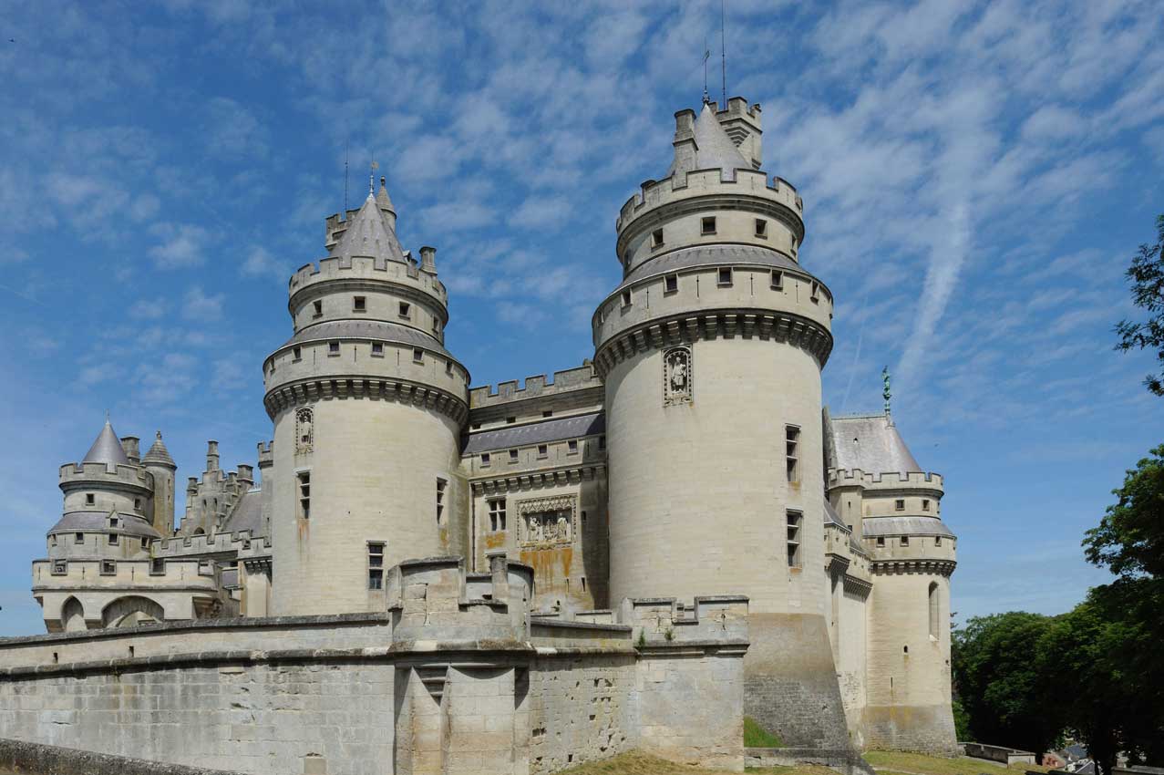