THEN: Framed by three cars, including a 1927 Pierce-Arrow (center) and 1927 Cadillac (right), Bleitz Funeral Home presides next to the Fremont Bridge and along the Lake Washington Ship Canal circa 1930. The building’s architect and builder are unknown. (Pierson Photo Co., Emmick Family Collection )NOW: In this wider view of the landmarked Bleitz building are (from left) Michael, Desirée and Craig Emmick, their firm’s 1972 Cadillac Miller Meteor hearse; Georgi Phelps of building owner Pastakia & Associates; Craig Smith of general contractor Foushée; and Leanne Olson, Maureen Elenga and Michael Herschensohn of the Queen Anne Historical Society. Demolition of a non-landmarked 1988 addition made possible the new, four-story office building at left. More info: the Bleitz page on Facebook and the Queen Anne Historical Society. (Clay Eals)
Published in The Seattle Times online on June 16, 2022
and in PacificNW Magazine of the printed Times on June19, 2022
Bleitz’s consumer-first legacy enlivens 101-year-old funeral home
By Clay Eals
From death can spring life. Case in point: the feisty, long-lasting Bleitz Funeral Home.
The 101-year-old edifice represents a customer-focused tradition at a prominent corner, hovering over the Lake Washington Ship Canal at the south end of the Fremont Bridge.
Serving bereaved families until 2017, the same year it was designated a Seattle landmark, it has entered a new phase as a fully leased office building, anchored by The North Face apparel firm. The pandemic-era preservation triumph was stewarded by its current owner, Pastakia & Associates of Seattle, and general contractor, Bellevue-based Foushée.
THEN: Jacob Bleitz (left) confers with his son, James, who followed in his father’s funeral-director footsteps. The chair in which James is sitting is still in use at Emmick Family Funeral Services in West Seattle. (Pierson Photo Co., Emmick Family Collection)
The stately, 2-1/2-floor concrete structure arose just four years after the ship canal and bridge were completed. Illinois-born Jacob Bleitz (pronounced “Blites”) had worked as an undertaker in Wichita before establishing a funeral business in 1904 in Seattle’s Green Lake neighborhood. After short partnerships in Fremont with morticians Edgar Ray Butterworth and John Rafferty, he crossed the bridge and settled his sole-owner mortuary in 1921 along Queen Anne’s industrial northern edge.
THEN: A full-page ad for Bleitz-Rafferty Co. in the Feb. 18, 1915, Seattle Star newspaper blasts overcharging for funeral services. Kilbourne Street is now North 36th Street in Fremont. (Washington Digital Newspapers)
From the start, dealing with death transcended mere business for Bleitz. He promoted affordability and excoriated undertakers he called predatory. “The People of Seattle Have Been Outrageously Overcharged for Funerals and Materials,” roared a full-page notice in the Feb. 18, 1915, Seattle Star. His ads promised the “lowest” prices. One even warned of “graft” by competitors whom Bleitz said gave away hundreds of Christmas turkeys to induce referrals.
April 19, 1938, Seattle Post-Intelligencer, p18.
Long before it became popular, Bleitz also encouraged a cheaper alternative: cremation. In the late 1930s, he went further, patenting and using an ultra-hot-flame technique leaving no remains, called evaporation: “The New And Better Way … COSTS NO MORE … Gives a comfort never before known.” It didn’t catch on.
In the year Bleitz died, 1939, the family firm partnered with the new People’s Memorial Benefit Association, a cooperative that emphasized spiritual rather than material aspects of attending to the bereaved. Later, the Bleitz company became known in funeral circles for serving AIDS victims and the LGBTQ+ community when other mortuaries rejected them.
THEN3: Lawrence Bleitz (left), younger son of Jacob Bleitz, stands at the KJR radio microphone while an unknown organist performs at Bleitz Funeral Home circa 1930. The pipe organ was removed and donated in 2005 to Blessed Seelos Catholic Church in New Orleans as part of Hurricane Katrina recovery. (Pierson Photo Co., Emmick Family Collection)
Over the years, Bleitz Funeral Home handled more than 180,000 deaths, including the cremations of famed grunge rockers Andrew Wood in 1990 and Kurt Cobain in 1994. Today the building showcases “adaptive reuse,” meriting an award in May from the Queen Anne Historical Society.
Historian Michael Emmick embodies the Bleitz legacy via family connections. Working stints at Bleitz were Michael’s great-grandfather, Sam Frederiksen (1970s-80s); father, Craig Emmick (1975-2004); and wife, Desirée Emmick, (2015-17). Since 2014, the Emmicks have operated their own West Seattle funeral business, guided by the Bleitz approach — as Michael says, “not selling people something they don’t need.”
WEB EXTRAS
Thanks to Eric Jones, Tejal Pastakia, Bob Carney and the Emmicks — Craig, Desirée and especially Michael — for their help with this installment.
To see Clay Eals‘ 360-degree video of the “Now” prospect and compare it with the “Then” photos, and to hear this column read aloud by Clay, check out our Seattle Now & Then 360 version of the column.
VIDEO (8:00): Click the image to see video interviews about Bleitz Funeral Home with Michael, Craig and Desiree Emmick of Emmick Family Funeral Services of West Seattle. (Clay Eals)Click image above to download the Seattle Landmarks Preservation Board minutes from April 19, 2017, regarding Bleitz Funeral Home.Click image above to download the Seattle Landmarks Preservation Board designation report for Bleitz Funeral Home, April 24, 2017.Drawing of Bleitz Funeral Home, 1921. (Emmick Family Collection)Cars outside Bleitz Funeral Home. (Emmick Family Collection)Casket letter, 1929. (Emmick Family Collection)(From left) Jeanne, Lawrence and James Bleitz, children of Jacob Bleitz. (Emmick Family Collection)Bleitz Funeral Home, 1937. (Puget Sound Regional Branch, Washington State Archives, Emmick Family Collection)Bleitz Funeral Home, 1937. (Puget Sound Regional Branch, Washington State Archives, Emmick Family Collection)1958 Cadillac and Chrysler outside Bleitz Funeral Home. (Emmick Family Collection)Bleitz Funeral Home, Sept. 20, 1960. (Puget Sound Regional Branch, Washington State Archives, Emmick Family Collection)Irene Clay Bleitz, Jacob Bleitz’s wife, outside Bleitz Funeral Home, 1944. (Emmick Family Collection)Bleitz Funeral Home, 1981. (Emmick Family Collection)Bleitz Funeral Home, 1981. (Emmick Family Collection)Bleitz Funeral Home, 1981. (Emmick Family Collection)Casket room, Bleitz Funeral Home, 1981. (Emmick Family Collection)Staff atop entrance, Bleitz Funeral Home, 1981. (Emmick Family Collection)Jacob Bleitz’s embalming certificate, June 1900. (Emmick Family Collection)Jacob Bleitz’s cremation furnace patent, 1932. (Emmick Family Collection)Jacob Bleitz and daughter-in-law Ebba Bleitz, August 1937. (Emmick Family Collection)Larry Bleitz, son of Jacob, and Irene Bleitz, wife of Jacob, 1944. (Emmick Family Collection)Möller organ, Bleitz Funeral Home, 1930s. (Emmick Family Collection)Looking northwest: Bleitz Funeral Home at far left, Nickerson Street and Fremont Bridge. (Seattle Municipal Archives, Emmick Family Collection)Bleitz home, 1900 Magnolia Blvd. W. (Emmick Family Collection)Bleitz home, 1900 Magnolia Blvd W. (Emmick Family Collection)Thank-you letter, April 8, 1927. (Emmick Family Collection)1928 Reader’s Digest article, “Profiteering on Grief.” (Emmick Family Collection)Mortuary Management article on showroom recommendations, February 1930. (Emmick Family Collection)Financial accounting for Malan, 1936. (Emmick Family Collection)Financial accounting for Nebenfuhr, 1936. (Emmick Family Collection)Financial accounting for Repco, 1936. (Emmick Family Collection)Bleitz blueprint. (Emmick Family Collection)Bleitz blueprint. (Emmick Family Collection)Bleitz blueprint. (Emmick Family Collection)Bleitz Funeral Home casket and flowers. (Emmick Family Collection)Bleitz Funeral Home contract. (Emmick Family Collection)Bleitz Funeral Home staff, 1981, including Craig Emmick, wearing sunglasses, center. (Emmick Family Collection)Bleitz Funeral Home crying room. (Emmick Family Collection)Bleitz Funeral Home drawing. (Emmick Family Collection)Bleitz Funeral Home meeting room. (Emmick Family Collection)Bleitz Funeral Home podium and piano. (Emmick Family Collection)Bleitz Funeral Home reception room. (Emmick Family Collection)Bleitz Funeral Home chapel. (Emmick Family Collection)Bleitz Funeral Home waiting room. (Emmick Family Collection)Feb. 6, 1905, Seattle Times, p2.Jan. 5, 1906, Seattle Times, p4.Feb. 5, 1906, Seattle Times, p4.April 28, 1907, Seattle Post-Intelligencer, p57.Oct. 16, 1908, Catholic Progress, p5.Feb. 9, 1915, Seattle Star, p9.May 27, 1915, Seattle Star, p5.June 3, 1915, Seattle Star, p5.June 10, 1915, Seattle Star, p3.Sept. 30, 1915, Seattle Star, p4.Nov. 14, 1916, Seattle Star, p4.Nov. 30, 1916, Seattle Star, p4.Dec. 21, 1916, Seattle Star, p4.June 21, 1917, Seattle Star, p4.Nov. 1, 1917, Seattle Star, p8.Sept. 12, 1919, Seattle Star, p25.May 21, 1920, Seattle Star, p11.May 18, 1922, Seattle Times, p27.March 27, 1923, Seattle Star.April 30, 1923, Seattle Star.May 20, 1923, Seattle Post-Intelligencer, p84.Nov. 5, 1924, Seattle Star.Feb. 24, 1934, Seattle Times, p19.Feb. 26, 1938, Seattle Post-Intelligencer, p20.April 24, 1938, Seattle Post-Intelligencer, p55.May 31, 1938, Seattle Post-Intelligencer, p8.May 14, 1938, Seattle Post-Intelligencer, p14.July 11, 1938, Seattle Post-Intelligencer, p15.Aug. 4, 1938, Seattle Times, p25.December 1939, Jacob Bleitz funeral notice. (Emmick Family Collection)Dec. 12, 1947, Catholic Progress.1964, Seattle Times. (Emmick Family Collection)May 25, 1968, Lawrence Bleitz obituary. (Emmick Family Collection)November 1983, Jim Bleitz obituary. (Emmick Family Collection)
THEN: The family of Carrie Coe stands near Denny Hall circa 1895. Named to honor the “father of the university,” Arthur A. Denny, the building was the first of many that filled the new north-end campus. Enough construction materials remained to erect a second building nearby, the still-extant observatory.(Courtesy Lucy Coe)NOW: A young family hailing from the south of France visits the UW campus on a chilly day in May. With graceful curves and towers and a light-colored stone exterior, chateau-like Denny Hall might have been transplanted from their homeland. (Jean Sherrard)THEN 2: The Dailey family in 1915. Arthur Dailey is seated at center, with Agnes Johnson Dailey at right. Sherrard’s maternal grandmother Dorothy Dailey, then 9 years old, stands at far left.
(Published in The Seattle Times online on June 9, 2022
and in PacificNW Magazine of the print Times on June 12, 2022)
All-in-one Denny Hall arose first on UW’s relocated campus
By Jean Sherrard
The proudest day of my great-grandfather’s life was the one marking his graduation from the University of Washington.
Arthur Dailey had arrived in Seattle two months before the Great Fire of 1889 from Kalamazoo, Michigan, soon finding a teaching job. At the advanced age of 30, he hoped that a collegiate diploma would assure his future.
With the rest of his 18-member class of ’97, displaying the school colors of purple and gold, he enthusiastically chanted the school cheer based on Chinook jargon that conveyed bravery and strength:
of W., Siah! Siah!
U. of W., Hiah! Hiah!
Skookum, Skookum, Washington!
This first graduation on the new UW campus, held May 28, 1897, marked another milestone in its 36-year history.
The school was founded on 10 acres downtown in 1861 by Arthur Armstrong Denny (1822-1899), leader of a 22-member party that had arrived on Alki only 10 years earlier. By 1891, the UW was bursting at its seams. Seattle’s population had exploded to more than 50,000, inhibiting further expansion.
To redress the pinch, the state Legislature approved relocating the UW to the then-rural Brooklyn Addition on the shores of Union Bay. The elderly Denny, still a tireless higher-education supporter, donated most of the 350 acres for a campus with room to boom.
Ground was broken for the university’s first north-end structure in 1894. A French Renaissance design by Charles W. Saunders (1858-1935) topped 24 other submitted sets of drawings. The resulting Administration Building, later renamed Denny Hall, came in well under its $150,000 budget, fed by low labor costs stemming from the depression of 1893.
Its 20,000 square feet housed all six of the university’s colleges and included 10 classrooms, a 6,000-volume library, faculty and administration offices and a 736-seat auditorium, all crowned by a belfry.
In September 1895, the edifice, comprising four floors of light-colored Enumclaw sandstone and pressed brick, trimmed with terra cotta and outfitted with the latest heating and plumbing, welcomed more than 200 students.
Our “Then” photo was snapped using Carrie Coe’s camera, likely in 1895, during a family outing to admire the newly completed building. Her husband, Dr. Frantz Coe, after whom Queen Anne Hill’s Coe School is named, was a future Seattle school-board member and friend of the Dennys. The tangle of bushes and a fresh-cut stump provide evidence of still-undeveloped wilderness on every side.
For his part, my great-grandpa Dailey made good use of the sheepskin, serving as principal to schools across the region. By 1899, he felt secure enough to marry his sweetheart, Ballard schoolteacher Agnes Johnson.
WEB EXTRAS
For our 360 degree narrated video version of this column, please take a short trip here!
THEN: Shown at the turn of the 20th century, the Bush House in recently logged Index fed and housed local miners and workers who built the Great Northern Railway. The inn was constructed by Clarence W. Bush. (Courtesy Museum of History & Industry)NOW: Owners of the Bush House Inn — Blair and Kathy Corson (back, third and fourth from left) and (next to them) Dan Kerlee (green shirt) and wife Carol Wollenberg (pink sweater) — join Index volunteers and the visiting Millers of West Seattle’s Husky Deli in late April in front of the hotel. Third from right in the front row, matriarch Marie Miller was celebrating her 93rd birthday. For IDs of most everyone in this photo and similar ones, see key below. (Clay Eals)
Published in The Seattle Times online on June 2, 2022
and in PacificNW Magazine of the printed Times on June 5, 2022
Index’s only inn perseveres amid historic charm and challenge
By Clay Eals
For more than 100 years, as a gravel road or streamlined pavement, the Stevens Pass Highway has beckoned as a cross-Cascades catalyst to intimate scenic bliss.
As we motor through a succession of tiny towns on the west side of the mountains, a rich palette of trees, bridges and railroad tracks along the Skykomish River feels so fresh, green and close, it’s as if we can reach out and touch the wide, deep swaths of crisp, wooded splendor.
The former timber and mining burg of Index, roughly 60 miles northeast of Seattle, once welcomed such pass-through traffic along its few unpretentious blocks via a 10-mile winding road from Gold Bar.
But the early 1930s brought modernization. The state constructed a shorter stretch of the highway that bypassed Index, leaving the hamlet one mile northeast of the new artery. It was, The Seattle Times stated on Sept. 13, 1931, part of “the steady movement to minimize the blockade of the Cascade range against the vast hinterland that feeds Seattle and Tacoma with produce for export and manufacturing.”
School buses head east on the Stevens Pass Highway, next to a sign previewing the turn-off to Index and the Bush House Inn. (Clay Eals)
Accessible via a turn-off road and ringed by four “Washington Alps” from to 5,464 to 6,244 feet in height, Index has persevered through the decades as a mini-paradise. Remoteness has both bolstered the town’s charm and embodied its challenge.
Enter the Bush House Inn. Built in 1898 (some say earlier), the three-floor structure competed with four other hotels for hungry lodgers when the Index population topped 500. Now it’s the only hotel in the riverside town of 150.
It presides on Index Avenue, nestled against a sheer, 1,270-foot climbing wall and a stone’s throw from Great Northern rail tracks whose freight trains and Amtrak cars regularly roll through town.
The inn suffered from disrepair and closure early this century. But after a decade of energy and financing marshaled by a pair of couples — Blair and Kathy Corson, proprietors of an Index recreational firm, and Dan Kerlee and Carol Wollenberg of Seattle’s Magnolia neighborhood — the extensively restored and remodeled 10-room hotel reopened last fall.
This effort merited a salute at last month’s gala of the Washington Trust for Historic Preservation, which in 2009 placed the inn on its list of Most Endangered Places.
The building holds promise as not only a travelers’ getaway but also a center for weddings, events and, with a new, expansive stage, concerts and dramatic productions. To echo its original incarnation, the owners are even searching for an on-site restaurateur.
Invisible from the highway, however, the Bush House Inn begs a “Field of Dreams”-like riddle: If you rebuild it, will they come?
To see Clay Eals‘ 360-degree video of the “Now” prospect and compare it with the “Then” photos, and to hear this column read aloud by Clay, check out our Seattle Now & Then 360 version of the column.
THEN: Framed by a pair of 1923-25 Ford Model Ts, the expanded Bush House stands in 1925 along a dirt road that is today’s Index Avenue. The town got its name because a nearby peak resembled an index finger. (Courtesy Runyon Collection, Index Museum)NOW: Owners of the Bush House Inn — Blair and Kathy Corson (back, second and third from left) and (next to them) Dan Kerlee (green shirt) and wife Carol Wollenberg (pink sweater) — join Index volunteers and the visiting Millers of West Seattle’s Husky Deli in late April in front of the hotel. Third from right in the front row, matriarch Marie Miller was celebrating her 93rd birthday. For IDs of most everyone in this photo and similar ones, see key below. (Clay Eals)Above is a key to the names of most everyone in the group photo above. Use this key to identify people in the other similar NOW photos. (Clay Eals)THEN: Elevated for repairs, the Bush House appears to be shored up by Index volunteers in 2012. (Kathy and Blair Corson)NOW: Owners of the Bush House Inn — Blair and Kathy Corson (fourth and sixth from left) and (next to them) Carol Wollenberg (pink sweater) and husband Dan Kerlee (green shirt) — join Index volunteers and the visiting Millers of West Seattle’s Husky Deli in late April in front of the hotel. Tenth from right in the front row, matriarch Marie Miller was celebrating her 93rd birthday. For IDs of most everyone in this photo and similar ones, see key above. (Clay Eals)THEN: A Great Northern train passes by the Bush House in its early days. (Courtesy Dan Kerlee)NOW: A similar view of the Great Northern train passing by today. (Clay Eals)
VIDEO (3:08): Click the image to hear Blair and Kathy Corson, co-owners with Dan Kerlee and Carol Wollenberg of the Bush House Inn, describe their involvement in the hotel and its town of Index, Washington. (Clay Eals)VIDEO (3:51): Click the image to see Carol Wollenberg & Dan Kerlee, co-owners with Blair & Kathy Corson of the Bush House Inn, describe their involvement in the hotel and its town of Index, Washington. (Clay Eals)July 2, 1902, Seattle Times, p8.Feb. 2, 1913, Seattle Post-Intelligencer, p56.May 7, 1916, Seattle Post-Intelligencer, p65.Aug. 9, 1919, Seattle Times, p15.May 27, 1920, Seattle Times, p12.April 23, 1927, Seattle Post-Intelligencer, p10.May 14, 1927, Seattle Post-Intelligencer, p9.May 12, 1928, Seattle Post-Intelligencer, p11.Sept. 4, 1931, Seattle Times, p13.Sept. 11, 1931, Seattle Times, p15.Oct. 22, 1931, Seattle Times, p9.Sept. 13, 1931, Seattle Times, p47.Feb. 27, 1932, Seattle Times, p3.Feb. 28, 1932, Seattle Times, p13.March 20, 1932, Seattle Times, p44.May 20, 1933, Seattle Times, p1.Sept. 27, 1978, Seattle Times, p83.Aug. 26, 1978, Seattle Times, p11.March 18, 1979, Seattle Post-Intelligencer, p29.March 18, 1979, Seattle Post-Intelligencer, p35.May 25, 1979, Seattle Times, p60.July 9, 1979, Seattle Post-Intelligencer, p3.July 5, 1980, Seattle Post-Intelligencer, p12.July 9, 1980, Seattle Times, p37.Aug. 23, 1980, Seattle Post-Intelligencer, p1.Aug. 23, 1980, Seattle Post-Intelligencer, p10.May 23, 1982, Seattle Times, p290.Oct. 6, 1984, Seattle Times, p29.June 16, 1985, Seattle Times, p118.June 16, 1985, Seattle Times, p119.Feb. 16, 1986, Seattle Post-Intelligencer, p93.May 17, 1987, Seattle Times, p146.May 17, 1987, Seattle Times, p147.June 14, 1987, Seattle Post-Intelligencer, p121.Sept. 25, 1988, Seattle Times, p182.Sept. 25, 1988, Seattle Times, p183.Sept. 25, 1988, Seattle Times, p184.Oct. 1, 1989, Seattle Post-Intelligencer, p148.Oct. 27, 1991, Seattle Post-Intelligencer, p131.Jan. 12, 1992, Seattle Times, p140.Jan. 12, 1992, Seattle Times, p141.Feb. 10, 1993, Seattle Post-Intelligencer, p11.Sept. 6, 1997, Seattle Post-Intelligencer, p21.Sept. 6, 1997, Seattle Post-Intelligencer, p22.Sept. 6, 1997, Seattle Post-Intelligencer, p23.Sept. 6, 1997, Seattle Post-Intelligencer, p24.Sept. 6, 1997, Seattle Post-Intelligencer, p25.Sept. 6, 1997, Seattle Post-Intelligencer, p27.
THEN 1: During shirtsleeve weather in late summer 1952. The Smith Tower barely peeks out above an Alaskan Way Viaduct nearing completion and free of traffic in this Boyd Ellis postcard. A one-hour Seattle Harbor Water Tours trip cost only $1. (courtesy Ron Edge)NOW: A somewhat wider view looks southeast at Pier 54. The Bremerton Fast Ferry, seating 118 passengers, pauses at its temporary berth at Pier 54. At 75 feet long, it has a beam of 27 feet. (Jean Sherrard)
(Published in The Seattle Times online on May 26, 2022
and in PacificNW Magazine of the print Times on May 29, 2022)
Visitors aboard a 1950s waterfront tour had to walk the prank
By Jean Sherrard
During her first visit to Seattle, Gwendolyn Dixon wrote home to her parents in tiny Green City, Mo., that she having a whale of a time. On the backside of this Boyd Ellis postcard, postmarked Aug. 25, 1953, she mentioned plans to take a one-hour boat tour of the harbor.
THEN 2: The back of the postcard sent by Gwendolyn Dixon to her parents in Green City, Mo. The town’s population has remained in the mid-600s since the 1950s. (courtesy Ron Edge)
Would that we could scratch and sniff Ellis’ photo, snapped a year earlier in 1952! A pungent working waterfront would spring to life.
Add the sound of ferry whistles, harbor gulls and the booming voice of Seattle Harbor Water Tours’ barker Rudi Becker (lower left) for full effect. The skipper on the flying bridge is likely Lynn Campbell or Joe Boles, company co-owners.
Campbell and Boles were particularly proud of their recent acquisition, named for a freak swell that nearly capsized the vessel on its passage from San Diego. After a $21,000 repair and facelift, the owners claimed the Wave was unique on the waterfront. Though sporting a conventional, 50-foot-long hull with a 13-foot beam, the cabin featured large, stainless-steel-framed, shatterproof panes of glass, providing spectacular harbor views for its 68 passengers.
And business boomed. Tourists and locals alike took in waterfront highlights, from Coast Guard weather ships and Smith Cove to United Fruit Company’s banana terminal. Most impressive, Campbell said, were the Todd drydocks at Harbor Island, “where you get to see how big a ship really is … and wonder how anything so heavy can float.”
During evening tours, Becker, a self-described “wharf rat,” could be heard tickling eager passengers: “By special permission of the chamber of commerce, we are permitted to include on this trip the sight of the setting sun.”
In the postcard’s background, above Alaskan Way, looming are pale concrete ribs of the nearly completed viaduct, which opened in April 1953. At right, near an octopus mural at the northeast corner of Pier 54, a mounted sign supplies evidence of Ivar Haglund’s aquarium. It drew many visitors for 18 years, until it was shuttered in 1956.
THEN 3 (possible online only): Ivar Haglund with one of his aquarium superstars, Oscar the Octopus. (courtesy Ivar’s)
A coda:
Joe Boles (1904-1962) made a late-life career change, improbably becoming the Northwest’s leading recording engineer, famously mastering the Wailers’ cover of “Louie, Louie.”
His partner, Lynn Campbell (1912-2013), offered harbor tours until his retirement, evolving the business into what is known today as Argosy Cruises.
Rudi Becker (1913-1976) served as a tour barker, wag and jokester for more than a decade. Watching tourists fill souvenir bottles with Elliott Bay water, he advised caution. “You better pour some out,” Becker said, “Come high tide, that bottle will break.”
Most tourists took it as Sound advice.
WEB EXTRAS
For our narrated 360 degree video of this column, please head over in this general direction.
And for further life aquatic, here’s a few photos of Ivar Haglund’s waterfront aquarium, courtesy of Ivar’s:
Ivar’s Aquarium interiorThe Aquarium flyerIvar with another favorite, the legendary Patsy the sealEddie, formally known as “Keeper of the Seal”A view of the fish tank
A late addition – the Times article from July 24, 1949 concerning the United Fruit Company’s Banana Terminal.
THEN: The Walnut Avenue house stands in 1942. Built in 1925, it was the Slate home until 1956, the Rounds home until 1985 and the Bigelow home until this spring. Clay Eals’ grandfather, Joseph Slate, maintained a vegetable garden in the grassy area at left, across Lander Street from Hiawatha Park. In 1966, the plot was split off, and a smaller house arose there the following year. (Eals family collection)NOW: Bill and Deb Bigelow stand before the Walnut house they owned from 1985 through this spring. Retired, they are moving south to Portland to live closer to their son and daughter-in-law. (Clay Eals)
Published in The Seattle Times online on May 19, 2022
and in PacificNW Magazine of the printed Times on May 22, 2022
A lovingly preserved house can help us find our way home
By Clay Eals
Can we go back home again? An oft-quoted aphorism says we can’t. But we all yearn to click our figurative ruby slippers.
THEN: Joseph and Florence Slate, first owners of the Walnut house, stand on its snowy back steps in January 1943. They sold the house in 1956 for $15,750 to Robert and Lois Rounds, who sold it in 1985 for $110,000 to Bill and Deb Bigelow. Its assessed value in 1938 was just $1,500. (Eals family collection)
In March, I learned that the home my grandparents had built 97 years ago on Walnut Avenue in West Seattle was up for sale. At its open house, I languished for two hours.
I imagined my young mom and her three older sisters running up and down its stairs and singing by an upright Ludwig piano in the first-floor sunroom. I pictured their pranks, one mischievously flushing a toilet while another talked with a boy on the nearby phone. I envisioned my parents’ wedding in front of the golden-brown tiled living-room fireplace, where in 2000 I posed them for a matching “Now” photo on their 50th anniversary.
Preschool-age recollections also surfaced as I sat on front-porch benches that opened into ostensibly secret storage pods. And I lingered in the remodeled kitchen where, in its former breakfast nook, I learned to sip from a straw.
In one sense, this house isn’t distinctive. Just a two-story, four-bedroom prairie Craftsman.
Yet its context, a stone’s throw from Seattle’s first indoor-outdoor community center at Hiawatha Park, has, for nearly a century, conveyed unspoiled neighborhood warmth. Seemingly everything one could want — schools, stores, even a library, ravine, wading pool and movie theater — was mere steps away.
Mainly, however, I marvel at a dwelling that has been owned by only three families, each one stewarding it with loving care.
Alisa and Brandon Allgood. (Courtesy Alisa and Brandon Allgood)
The soon-to-be fourth family, Brandon and Alisa Allgood, hail from California’s Silicon Valley. Brandon, 47, is an artificial-intelligence executive, and his wife, Alisa, 53, is an architectural and interior designer.
Because Brandon grew up in Marysville and on Capitol Hill and has family near Arlington and Darrington, the two have long eyed a move to Seattle. They got serious in February, gravitating to the Walnut house because of its streetside stature, open floor plan, plentiful light, proximity to Alki Beach and what today is called walkability. “We didn’t want run of the mill,” Brandon says. “We like aesthetics and uniqueness.”
The pair anticipates electrical and plumbing upgrades but will retain the house’s integrity. “We realize,” Alisa says, “we have a responsibility to keep it up.”
In Seattle’s dizzying real-estate spiral, preservation comes with a price — in this case, a purchase in excess of $1.4 million. As the cliché goes, for many the so-called American Dream remains just that: a dream.
But I also know that my early time at the Walnut house eventually led me to claim West Seattle as my own Emerald City base. May similar homes survive everywhere to inspire us all.
THEN: In 1929, Clay Eals’ mother, Virginia Slate (left), and her sister, Betty, stand in back of the Walnut house, dressed as a “man and woman act” that performed “the cakewalk” four blocks away at the Portola Theatre, which in 1942 was enlarged to become today’s Admiral Theatre. (Eals family collection)THEN: Joseph and Florence Slate, first owners, stand in back of the Walnut house in the mid-1940s. (Eals family collection)
WEB EXTRAS
Special thanks to Bill Reid, Whitney Mason, Midori Okazaki, Ann Ferguson, Mahina Oshie, Joe Bopp and especially Deb & Bill Bigelow for their help with this installment.
To see Clay Eals‘ 360-degree video of the “Now” prospect and compare it with the “Then” photos, and to hear this column read aloud by Clay, check out our Seattle Now & Then 360 version of the column.
Below are a video interview of Deb Bigelow, 7 additional photos, a property record card from the Puget Sound Regional Branch of Washington State Archives and 12 historical clippings from The Seattle Times and Seattle Post-Intelligencer online archive (available via Seattle Public Library) that were helpful in the preparation of this column.
VIDEO (12:17): Click this image to see an interview with Deb Bigelow, who with her husband Bill owned the Walnut Avenue home from 1985 through spring 2022. (Clay Eals)The Walnut Avenue house on April 12, 1926, shortly after the Slate family moved in. The oblong angles result from correcting the photo’s horizon line. (Eals family collection)A rear view of the Walnut Avenue house on April 12, 1926, shortly after the Slate family moved in. The oblong angles result from correcting the photo’s horizon line. (Eals family collection)The Walnut house today, near the corner of Walnut Avenue Southwest and Southwest Lander Street. (Clay Eals)The Walnut house, built in 1925, with a newer home (left) built in 1967 on the former Slate vegetable garden. (Clay Eals)Mountain detail of the golden-brown tiled living-room fireplace of the Walnut house. (Clay Eals)Mountain detail of the golden-brown tiled living-room fireplace of the Walnut house. (Clay Eals)A two-page spread in the April 2022 edition of Old House Journal, featuring the remodeled kitchen of the Walnut house. (Clay Eals)Click the image to download a pdf of the late-1930s Property Record Card for the Walnut house. (Puget Sound Regional Branch, Washington State Archives)Nov. 18, 1926, West Seattle Herald indicates Walnut house as meeting site.March 11, 1934, Seattle Times, p11, indicates Walnut house as polling place.March 13, 1934, Seattle Times, p2, indicates Walnut house as site of polling place.Dec. 6, 1936, Seattle Post-Intelligencer, p44, indicates Walnut house as luncheon site.June 23, 1937, Seattle Times, p39, indicates lot north of Walnut house for sale.Jan. 21, 1939, Seattle Times, p13, indicates Walnut house as site of talk.April 7, 1939, West Seattle Herald indicates Walnut house as club meeting site.May 25, 1939, West Seattle Herald indicates Walnut house as club meeting site.August 1956 ad in West Seattle Herald indicates Walnut house for sale.Aug. 15, 1956, Seattle Times, p52, indicates Walnut house for sale.Oct. 30, 1983, Seattle Post-Intelligencer, p74, indicates Walnut house for sale.July 22, 1984, Seattle Times, p72, indicates Walnut house for sale.
THEN1: The three bay windows of the Wayne Apartments at far left mark the start of Denny Hill’s incline prior to 1903. More than a hundred feet of its slopes were incrementally sluiced away through 1930, leaving behind flatland Belltown.NOW1: Soon to be demolished, the Wayne Apartments’ bay windows (upper left) are partly concealed by foliage. Buster Simpson (left) and Steve Hall stand in the crosswalk at Second and Bell. (Jean Sherrard)
(Published in The Seattle Times online on May 12, 2022
and in PacificNW Magazine of the print Times on May 15, 2022)
A surviving signpost to Belltown’s origins soon will fall
By Jean Sherrard
Some ancient parchment, as historians know, is scrubbed clean and rewritten upon while leaving behind faint traces of the original text. Such a page is known as a palimpsest.
When exploring the crosshatch of Seattle streets and architecture with this column’s founder Paul Dorpat two decades ago, I realized that his X-ray photographic vision of our ephemeral city included similar traces. The residues, like double exposures, appeared in unlikely places and cracked open historical clues and mysteries aplenty.
This week’s “Then” photo revisits an early discovery of Paul’s that cemented his vocation as historical detector and photographic repeater. He penned a lengthy account of his efforts in the Dec. 20, 1978, edition of the weekly Seattle Sun. The headline: “Digging Up the Past of the Late and Great Denny Hill.”
Perusing a photo collection, he came upon a portrait of the city unlike any he had seen. While “uncannily familiar,” this image did not seem to match Seattle’s existing topography. Paul concluded that it was a place “that had somehow lost its future, for it appeared to be in no way findable in our here and now.”
Then came a “Eureka!” moment.
With a magnifying glass, the name “Bell” emerged on a street sign. Familiar with Mama’s Mexican Restaurant at the corner of Second and Bell, Paul was thrilled to recognize the triple set of bay windows belonging to the Wayne Apartments, built in 1890.
The original clapboard had been covered with asbestos “war brick” siding, but the pictorial puzzle was solved. Denny Hill’s “back side,” 220 feet above sea level, was revealed in this rare, south-facing view of what today is called Belltown, captured just before an early regrade of 1903.
Among few remaining pre-regrade structures, the bay-windowed Wayne has shone prominently and repeatedly over four decades — in “Now & Then” in 1984 and in lectures and books, including our 2018 tome “Seattle Now & Then: The Historic Hundred.” The edifice has born witness to change, loss and the thrill of discovery.
But not for long.
In early April, we received word from artist Buster Simpson and Steve Hall, a preservation advocate with Friends of Historic Belltown, that the Wayne and adjacent structures along Second Avenue soon will be destroyed. Though they achieved landmark status in 2015, exemptions to the ruling are allowing a prospective 9-floor retail-residential building to fill the space. Its height will more than match the original summit of Denny Hill.
In the rueful words of historian David B. Williams, modern developers seem to be “merely rebuilding the hill one banal building at a time.”
WEB EXTRAS
THEN2: This rare 1895 view looks northwest from the top of Denny Hill, on the bluff above Second Avenue. At right, the home at 216 Lenora Street belonged to Seattle ex-mayor Robert Moran, who also snapped the photo. (Courtesy Hal Will)
NOW2: Increasingly decrepit, the Wayne’s 132-year-old sagging roofline soon will be replaced by a 9-floor building, with retail on the bottom and apartments above. (Jean Sherrard)A few photos of the soon-to-vanish icon follow. Accompanied by Buster Simpson, I explored the back of the old Wayne apartments and crawled up a couple rotting staircases. A special prize for those who find the pigeon eggs.
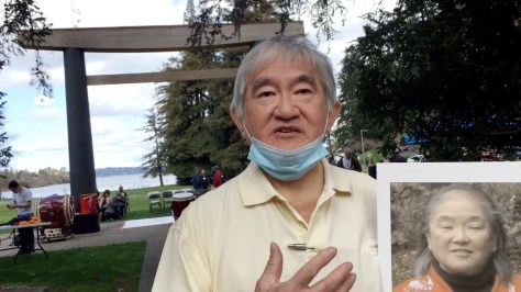
THEN1: With cherry blossoms abloom and the Seward Park torii to the north behind him, Don Taniguchi, 7 or 8 years old, stands near the park’s entry in 1953 or 1954. The torii was moved to this site in 1935. (Courtesy Taniguchi family)NOW1: Before the April 2 ceremony to dedicate the new torii behind him, Don Taniguchi stands about 20 feet north of his childhood pose and holds a portrait of his late sister Diane, who raised funds for the project. Flanking him are the concrete foundations of the original span. The event was organized by Friends of Seward Park, Seattle Parks Foundation and Seattle Parks and Recreation. (Jean Sherrard)
Published in The Seattle Times online on May 5, 2022
and in PacificNW Magazine of the printed Times on May 8, 2022
Seward Park’s torii was a welcome gateway, especially for a child
By Clay Eals
Unaware of her parents’ painful memories of World War II incarceration at Camp Tule Lake in northern California, preschooler Diane Taniguchi found that weekends in the early 1950s promised a family frolic.
“We used to take joy rides on Sunday afternoon after church,” Diane said in a 2015 video, citing drives from their home in the Publix Hotel in what is now called the Chinatown-International District to a South Seattle peninsular paradise — Seward Park.
“Dad called it ‘Suwado Pock’ because he couldn’t say r’s, and his pronunciation was still very Japanese right after the war. But those were great times. It was carefree. I was 4 or 5 years old. Not a worry in the world.”
Welcoming the Taniguchis and myriad other park visitors was a cultural symbol that Diane “really loved” — an imposing, reddish span modeled on entrance structures at Shinto shrines in Japan, called a torii. Pronounced “torr-ee,” the word means “bird perch,” but such structures have become known more broadly as gateways to extraordinary spaces.
THEN3: In a still image taken from family home-movie footage, the torii stands in its original spot, on University Street between Fourth and Fifth avenues, for the 1934 International Golden Potlatch. The sign at top reads: “Seattle — America’s Gateway to the Orient.” Sponsored by the Seattle Japanese Chamber of Commerce, the torii’s total cost was just $172. (Kushi Collection, University of Washington Special Collections)
The wooden Seward Park torii had a 50-year life, starting on University Street downtown at the 1934 International Potlatch and bearing a pro-trade sign: “Seattle — America’s Gateway to the Orient.”
The following spring, the torii (sans sign) found a verdant site at Seward Park’s entry isthmus, joining other Japanese elements, including cherry trees and an 8-ton stone lantern. It oversaw festivals and countless informal meadow gatherings through mid-1984, when Seattle Parks removed it due to decades of decay.
In 2011, the park’s centennial organizers vowed to build a new version. Fueled by $360,000 in grants and donations, a 20-foot-tall basalt-and-cedar replacement stands today in a plaza 20 feet north of the original’s tree-confined concrete foundations. At an April 2 ceremony, a crowd of 200 enjoyed musicians, dancers and speakers exulting beneath the edifice.
Officiants included Don Taniguchi, 76, honoring his younger sister, Diane, a preservationist who helped raise money for the new torii but died of cancer in 2016. Don’s thoughts also drifted to their dad, originally from Hawaii, and mom, of Tacoma, who both stayed silent about their camp challenges and the complexity of their new life while working “all the time” managing the Publix.
“They didn’t talk about the hardships,” Don says. “I guess it hurt them too much.”
From youthful eyes, he says, Seward Park and its torii bespoke “family time,” a cheerful refuge. “You felt a little prejudice, like somebody getting in line ahead of you, but you didn’t really understand why,” he says. “You didn’t think about those things. You just played. … You cherish those days now.”
NOW2: Drummers from the School of Taiko kick off the April 2 ceremony. (Jean Sherrard)NOW3: Mayor Bruce Harrell speaks at the April 2 ceremony: “Being of biracial background [Japanese American and Black], I try to find out what’s common in cultures,” he said. “That’s what this [torii] represents: oneness. … This is Seattle at its best.” (Jean Sherrard)
WEB EXTRAS
Special thanks to Paul Talbert of Friends of Seward Park and Karen O’Brien of the Rainier Valley Historical Society, as well as automotive expert Bob Carney and former Seattle Parks staffer Bob Baines for their help with this installment. For more info, visit their Seward Park torii page.
To see Jean Sherrard‘s 360-degree video of the “Now” prospect and compare it with the “Then” photos, and to hear this column read aloud by Clay Eals, check out our Seattle Now & Then 360 version of the column.
VIDEO (23:12): Click the image to view the Friends of Seward Park documentary on the campaign to re-create the Seward Park torii. An interview of Diane Taniguchi can be seen at time code 17:31. (Friends of Seward Park)VIDEO (1:59): Click the image to see Don Taniguchi interviewed about his sister and childhood days at Seward Park. (Clay Eals)VIDEO (1:54): Click image to see state Rep. Sharon Tomoko Santos speak at Seward Park torii dedication ceremony. (Clay Eals)VIDEO (7:16): Click the image to see Seattle Mayor Bruce Harrell speak at the Seward Park torii dedication ceremony. (Clay Eals)VIDEO (2:48): Click the image to see excerpts of performances at the Seward Park dedication ceremony. (Clay Eals)Diane and Don Taniguchi in about 1953. (Courtesy Taniguchi family)The Taniguchi family, with young siblings Don and Diane in front, stands before the old Seward Park torii in the early 1950s. (Courtesy Taniguchi family)Girls participate in a running race in the meadow near the old Seward Park torii during the annual Rainier District Pow-Wow on July 31, 1950. (Courtesy Rainier Valley Historical Society)Officials preside at a 50th anniversary ceremony for the old Seward Park torii in July 1983, including (from right) state Rep. John O’Brien, Seattle Mayor Charles Royer, real-estatte agent John Merrill, Seafair pageant queen and princesses. (Courtesy O’Brien family)Three days before the April 2, 2022, ceremony to dedicate the new Seward Park torii, Paul Talbert of Friends of Seward Park displays a section of the old torii on its western concrete base. (Clay Eals)The same section of the old torii on display at Seward Park. (Clay Eals)Sides of a marker credit donors to the new Seward Park torii project. (Clay Eals)A marker credits donors to the new Seward Park torii project. (Clay Eals)Story marker for the new Seward Park torii. (Clay Eals)Aug. 26, 1934, Seattle Times, p9.Aug. 21, 1938, Seattle Times, p72.April 15, 1945, Seattle Times, p31.April 2, 1962, Seattle Times, p44.
Longtime Seattle historian Paul Dorpat, founder of the “Now & Then” column that appears Sundays in The Seattle Times (and with “web extras” on this blog), will receive the 2022 Board Legacy Award of the Association of King County Historical Organizations (AKCHO).
The honor will be presented during AKCHO’s annual awards event, online, from 5:30 to 7:15 p.m. Tuesday, May 24, 2022. To view the event, visit this link. Paul’s award is being saved for the end!
The award to Paul is triggered by his recent donation of a vast collection of historical photos, videos and printed materials to the Seattle Public Library so that they eventually can be accessed by anyone free of charge.
The donation reflects “your legendary loyalty to identifying and celebrating Seattle history,” says Pat Filer, award chair.
Paul, the author of many local history books, originated “Now & Then” in the Sunday magazine of The Seattle Times in January 1982. He prepared more than 1,800 columns over 37 years before retiring in 2019.
VIDEO (3:21): Click this image to see Paul’s award acceptance speech. (Clay Eals)
THEN: The Beatles — (clockwise from top) Paul McCartney, John Lennon, Ringo Starr and George Harrison — cast for fish in Elliott Bay from a window in room 272 of Seattle’s Edgewater Inn on the afternoon of Aug. 21, 1964, before delivering a 30-minute show that night at the Coliseum. (Clay Eals collection, possibly by Curt Gunther — see below)NOW: Gleefully replicating the Beatles’ 1964 pose in a narrower window opening in the Beatles Suite of The Edgewater Hotel (no longer Inn) are four Seattle-area women who attended the 1964 show: (from top) Joey Richesson, Garnis Armbruster Adkins, Teresa Anderson and Carol Griff Reynolds. Peeking out behind them are Pier 69, redeveloped in the early 1980s, as well as Magnolia bluff, Bainbridge Island and the Olympics. (Jean Sherrard)
Published in The Seattle Times online on April 28, 2022
(visit that link for many extra photos!)
and in PacificNW Magazine of the printed Times on May 1, 2022
The Beatles found good fishing for young fans in 1964 Seattle
By Clay Eals
A long-ago best friend sometimes offered a question at social gatherings as an icebreaker: “What was your first concert?” One by one, all would mention fond memories of musicians and venues. Taking the final turn, my friend would stun everyone with three words:
“Beatles, 1964, Coliseum.”
The show was an instant Seattle legend. The third in 23 cities of the Beatles’ first North American tour, the Aug. 21 stop at what today is called Climate Pledge Arena drew a sellout throng of 14,045. Mostly young teens, reportedly “20 to 1” girls to boys, each paid just $3, $4 or $5 to contribute and/or endure waves of nearly continuous ear-splitting screams that all but drowned out the foursome’s half-hour, 12-song set.
This “Beatlemania” and attendant controversies typified the entire tour, reporters summoning the swoons historically incited by the likes of Elvis Presley, Frank Sinatra and even silent-film’s Rudolph Valentino.
Sept. 2, 1962, Seattle Post-Intelligencer, p9.
What gave the Beatles’ visit a distinctly Seattle touch was their overnight at the waterfront Edgewater Inn, then 2 years old. From room 272, the “moptops” leaned out a window and famously posed with fishing poles over Elliott Bay.
Did they catch anything? No, they agreed at a press conference. Drummer Ringo Starr deadpanned, “Someone on the other side of the bay kept shouting, ‘There’s no fishing here.’ ”
Sandy Fliesbach, 11, holds Beatles autographs she secured by “fishing” out her window. See full story in news clips below. (Stuart B. Hertz, Seattle Post-Intelliegencer)
Endearingly, one floor above them, 11-year-old Sandy Fliesbach, attending a wedding at the Edgewater, cast her own line. On hotel stationery she wrote a note seeking the Fab Four’s autographs, lowering it out her window with ribbon from opened gifts. She whistled, and someone below pulled in the note. A minute later, it came back out the window, and Sandy reeled it in. All four had signed it. Hundreds of girls chanting outside the inn’s temporary plywood and barbed-wire barricade were not so fortunate.
Two years later, the Beatles returned for two shows at the Coliseum. After the group’s 1970 break-up, John Lennon never had another Seattle gig (he was shot and killed in 1980). George Harrison played the Coliseum in 1974 (he died in 2001). Starr and Paul McCartney have performed here in several separate incarnations, the latter’s Wings group notching the first concert at the old Kingdome in 1976.
Paul McCartney 2022 tour logo.
Astoundingly, the still-boyish McCartney, just six weeks shy of age 80, will play Climate Pledge on May 2-3. Perhaps he would twist and shout over a 58-year-old crack by parodist Allan Sherman (“Hello Muddah, Hello Faddah”), who played the Opera House and bunked at the Edgewater during the Beatles’ 1964 Seattle stay:
“The Beatles are really quite unpopular, but nobody knows it yet.”
Beatles, 1964, Coliseum — just the facts
Set list: “Twist and Shout,” “You Can’t Do That,” “All My Lovin’,” “She Loves You,” “Things We Said Today,” “Roll Over Beethoven,” “Can’t Buy Me Love,” “If I Fell,” “I Want to Hold Your Hand,” “Boys,” “A Hard Day’s Night,” “Long Tall Sally.” To hear audio of their show, click here.
The Beatles play their Aug. 21, 1964, show at the Coliseum. John Lennon (left) and Ringo Starr on drums are recognizable. Note the extra drum set for opening acts, plus Navy volunteers in the foreground. Also in the foreground, with blonde hair, facing left and in a white sleeveless dress, is Colleen Convis Holmes, sister of the photographer, Christi Convis Perrault. Edward Holmes, husband of Colleen, recalls: “Both she (Colleen) and I were driven (separately) to the concert by our older sisters, who had just gotten their driver’s licenses. I was 13 and was forced to go because my parents didn’t want my sister to drive alone to Seattle. I could hear only the first few notes of every song before the teenage-girl screaming drowned the boys out. I was a very long way from the stage. I had zero interest in the Beatles, but I’m now glad I went. I met my wife 9 years later at the University of Washington.” (Christi Convis Perrault, courtesy Edward Holmes)
Sound: The Beatles’ set, measured by acoustic expert Robin Towne, was 95+ decibels for 60% of the show and 100+ decibels for 30%. (Maximum exposure without earplugs, such as an industrial plant, was recommended as 85 decibels.)
Bucks: The show grossed $64,000. The Beatles were to earn $25,000 or 60% of the gross, whichever was greater, so after $7,000 in taxes, they were paid $34,200. Minus fees for warm-up acts, their take-home was $32,000 ($278,000 today).
Warm-up acts: the Bill Black Combo, the Exciters, the Righteous Brothers and Jackie DeShannon. (Smash hits for the latter two came later.)
Security: At the Coliseum were 50 Seattle police, 4 King County deputies, 14 firefighters, 6 Armed Forces police and 100 Navy volunteers from Pier 91.
Health: Hospitalized were 2 teens; 35 others received first aid. On hand were 5 ambulances, one of which carried the Beatles back to the Edgewater.
Souvenirs: After the Beatles left Seattle, their room 272 rug at the Edgewater was cut into 2-inch squares that sold for $1 apiece at MacDougall’s department store, to benefit Children’s Orthopedic Hospital.
Airwaves: The Beatles had five songs on KJR-AM’s Fabulous 50 the week of their Seattle show.
Silver screen: Playing the Paramount Theatre during the show was the Beatles’ first film, “A Hard Day’s Night.”
Special thanks to Kelsey Beniasch and Claudia Lew of Wagstaff Marketing, to staff of The Edgewater Hotel, to Joe Wren and Gavin MacDougall and especially to Teresa Anderson, Garnis Armbruster Adkins, Carol Griff Reynolds, Joey Richesson and Kate “Bobbey” Blessing, for their help with this installment.
Click here to see a previous “Now & Then” column on the Edgewater.
We offer no 360-degree video for this installment, but instead we feature a video with interviews of all the participants in our “Now” photo (plus a backup), in which they reflect on the Beatles’ 1964 show at the Coliseum. To see it, click here or on the image below.
VIDEO (6:20): Click image to see video interviews of our “Now” photo participants about their experiences at the Beatles’ 1964 show at the Coliseum in Seattle. (Clay Eals)
To start off the extras, we have an essay by Clay examining the orientation of our “Then” photo:
Hocus-focus: Here is our THEN photo, flopped in both directions, the Beatles facing right and facing left. Both versions can be found on the internet. (Clay Eals collection)
‘All I’ve got is a photograph ‘ : Flipping over the Beatles
By Clay Eals
The topic du jour is the orientation of our color “Then” photo, the well-known image of the Beatles fishing out the window of their room 272 suite at the Edgewater Inn on the afternoon of their evening show Aug. 21, 1964, at the Coliseum.
On the internet, it’s easy to find our “Then” in two versions, one in which the Beatles face right, and one in which the Beatles face left. But which version is correct? I was determined to solve the puzzle prior to our “Now” shoot.
Details of the Beatles’ hair parts and shirt collars in the photo, compared to the same details in several other photos from Getty Images of the Beatles inside their Edgewater suite, seemed to indicate that that the facing-right version was correct. I also was skeptical of a facing-left orientation because the low-level, indistinct masses in the background appeared to me to likely depict Harbor Island and its ships and shipyards. However, the Edgewater’s website, as well as a blown-up display inside room 272 and a framed photo in the hotel lobby all use the facing-left version.
With these conflicting notions in mind, before our “Now” shoot I made a separate trip to the Beatles Suite (still room 272) of The Edgewater Hotel (formerly Inn) in the hope of figuring out the correct orientation. The Edgewater staff asserted that room 272 is in the same west/southwest-facing corner spot today as it was in 1964. When I examined the room’s windows and leaned out them, taking sample photos, it seemed clear to me that the facing-left version had to be correct.
I had two reasons for this conclusion: (1) The positioning of the fishing window immediately adjacent to the building’s corner in the facing-left version is consistent with the present-day position of a similar window along present-day room 272’s exterior wall that runs northwest/southeast. (2) Given this, if the facing-right version were correct, from the window of today’s room 272 the photographer would have looked southeast and captured in the distance the Smith Tower and the rest of Seattle’s 1964 waterfront and downtown scene, but instead we see the low-level, indistinct mass. This argued for the photographer shooting in a northwestern direction — the direction shown in the version with the Beatles facing left.
As I looked northwest from outside the room 272 window, I noted that the end of Pier 69 that jutted out in the background was not present in the 1964 “Then.” But this could be explained by separate newspaper research indicating that Pier 69 had been redeveloped in the early 1980s.
Thus, the facing-left orientation seemed the better bet when Jean Sherrard and I shot our “Now” photo on March 24, 2022. Jean looked northwest, and our four “Now” posers matched the Beatles, facing left. That’s how they appear in this post and in the Seattle Times online and in print.
But on April 29, 2022, after this column had been posted for a day, the plot thickened. New evidence and insight emerged from one of our column’s stalwart volunteers, Gavin MacDougall.
Though I had searched Google Images and Getty Images for relevant Beatles fishing photos, Gavin’s own search turned up two Getty black-and-white versions of out-the-window Beatles fishing photos that I hadn’t seen — and that obviously were taken slightly before or after our “Then.” These photos, which you can see at this link, and at this link, provide definitive evidence that the correct orientation of the photo has the Beatles facing right, not left.
Here’s why: The background of these black-and-white photos is much more distinct than in the color photo of the same situation. Clearly in the background are not only Harbor Island and silhouetted ships in for repair but also a ribbon of white further in the distance reflecting construction underway on the Fauntleroy Expressway snaking diagonally up the east bluff of West Seattle.
But how could this be, if this view is not possible from the windows of present-day room 272? The answer, as the Edgewater had told me, is that in 1964 when the Beatles stayed in room 272, the room was larger and/or likely connected to adjacent rooms, whereas today’s room 272, marketed as the Beatles Suite, is smaller and designed for a couple, not a Fab Foursome. So in 1964, the larger version of room 272 had to extend around the corner along part of the adjacent exterior wall that ran due north and south and included windows that faced due west. Thus, when the Beatles fished out the southernmost window along that wall, the photographer leaning out the window to its north would have been facing due south and would have shown Harbor Island and West Seattle in the background of the resulting photos.
That room 272 was larger and provided windows straddling the Edgewater’s west/southwest facing corner is apparent from the Getty photo at this link. There, the fishing window is shown at right, and drapes cover another window at left on a wall that is at an irregular angle to the fishing-window wall, indicating the corner.
Bottom line: Though I tried hard to suss out this question before the “Now” shoot, I should have been able to dig up the Getty Images that served as the “smoking gun.” Had I done so, we would have flopped our 1964 “Then” photo so that the Beatles were facing right. We also would have sought access from the Edgewater to the room next door to — and around the irregular corner of — today’s Beatles Suite in room 272 to shoot our “Now.”
Why take pains to explain this how this error occurred? A whimsical answer may lie in the chorus of a 1973 Ringo Starr song, “Photograph”:
“All I’ve got is a photograph And I realize you’re not coming back anymore …”
Incidentally, while versions of the out-the-window fishing photo have been widely circulated in both orientations, its photographer is rarely mentioned. KOMO-TV archivist Joe Wren notes that in a 1995 interview that Beatles companion and confidant Derek Taylor did with the station, the photographer for the exterior fishing shot was identified as the Beatles’ official photographer, the late Curt Gunther. But such attribution is made difficult by the assertion on the Getty Images website that several photos of the Beatles inside their Edgewater suite were taken by a William Lovelace. The mystery continues, but here’s the KOMO-TV story, aired April 28, 2022:
VIDEO (3:34): Click the image to see a KOMO-TV story from April 28, 2022, in which Derek Taylor identifies Curt Gunther as the photographer for the fishing photo. (Joe Wren)
=====
More photos, a ticket stub, a letter, another video, an essay,
an array of news clippings and the Beatles’ 1964 tour booklet
Here are additional photos taken March 24, 2022, the day of our “Now” shoot, of the Edgewater’s Beatles Suite and of our “Now” posers therein. At the end of this gallery you will find a brief video of our posers standing before a Fab Four portrait in the suite’s bathroom gamely making their way through a minute or so of one of the songs the Beatles sang at their 1964 show: “I Want to Hold Your Hand.”
ALTERNATE NOW: Replicating the Beatles’ serious facial expressions in their 1964 fishing pose in a narrower window opening in the Beatles Suite at The Edgewater Hotel (no longer Inn) are four Seattle-area women who attended the 1964 show: (from top) Joey Richesson, Garnis Armbruster Adkins, Teresa Anderson and Carol Griff Reynolds. (Jean Sherrard)Our Beatles “Now” posers — (from left) Carol Griff Reynolds, Garnis Armbruster Adkins, Joey Richesson and Teresa Anderson — stand in The Edgewater Hotel lobby before the 1964 photo they replicated. (Jean Sherrard)Our Beatles “Now” posers — (from left) Carol Griff Reynolds, Garnis Armbruster Adkins, Joey Richesson and Teresa Anderson — stand in The Edgewater Hotel lobby, saluting the 1964 photo they replicated. (Jean Sherrard)The bedstead in the Beatles Suite of The Edgewater Hotel. A one-night stay in the suite goes for $700 today. (Jean Sherrard)The bathtub in the Beatles Suite of The Edgewater Hotel. A one-night stay in the suite goes for $700 today. (Jean Sherrard)VIDEO (1:14): On March 22, 2022, five women who attended the Beatles’ 1964 show at the Coliseum in Seattle — Joey Richesson, Kate “Bobbey” Blessing, Teresa Anderson, Carol Griff Reynolds and Garnis Armbruster Adkins, good sports all — stand in the bathroom of the Beatles Suite of The Edgewater Hotel and make their way through a portion of a song the Beatles sang that night 58 years ago, “I Want to Hold Your Hand.” (Clay Eals)
=====
This is Teresa Anderson’s ticket stub from the Beatles’ Aug. 21, 1964, show at the Coliseum. (Teresa Anderson collection)A plaintive 1964 letter to Seattle Mayor Dorm Braman from a young Lu Ellen Peterson. (Seattle Municipal Archives)Click this image to download a pdf of a detailed article from summer 1996 Columbia magazine on the Beatles’ 1964 show at the Coliseum.
=====
These 57 newspaper clippings document the Beatles’ 1964 show in Seattle:
These photos depict the Beatles’ 1964 tour booklet “Beatles (U.S.A.) Ltd.,” available for purchase at their shows. The images are courtesy of Teresa Anderson. Click once or twice on each one to enlarge it. At the very bottom is the cover for the Beatles’ 1966 tour booklet, contributed by Deb Bigelow.
Cover of 1966 Beatles program. (Courtesy Deb Bigelow)
THEN: Like a Dutch Masters landscape painting, the Little White Church on the Hill anchors a pastoral scene. The Stillaguamish River curves just below, while the distant bluffs of Camano Island peep above the central horizon. The church’s steeple was added in 1904. Our best guess is that this photo was taken before 1910. (Paul Dorpat collection)NOW 1: A remarkably similar landscape shows that little has changed in this rural landscape since our “Then” photo was snapped from atop the bluff. The Stillaguamish River, now screened by evergreens, still overflows its banks on occasion. (Jean Sherrard)NOW 2: Captured on a clear day in mid-March, the Little White Church includes the grounds of Zion Lutheran Cemetery, where a number of pioneer families are buried. (Jean Sherrard)NOW 3: In an east-facing photo, the pioneer church gleams in late afternoon light. The “Then” and “Now” portraits were taken from the bluff above the structure. (Jean Sherrard)
(Published in The Seattle Times online on April 21, 2022
and in PacificNW Magazine of the print Times on April 24, 2022)
With a peaceful view, Silvana’s Little White Church endures
By Jean Sherrard
In an increasingly discordant world, we scan for hopeful signs and clues – some are lodged in the past. One symbol of reunion and healing might be found on a rural hillside an hour’s drive north of Seattle.
The tiny town of Silvana, founded in the 1880s by Scandinavian farmers, was both blessed and cursed by the fertile floodplain of the Stillaguamish River. To accommodate the river’s oft-overflowing banks, its houses and sidewalks were raised several feet above ground level.
Little surprise, then, that the vigorous young congregation of Zion Lutheran, led by itinerant pastor Christian Jorgensen, decided to build its church and adjacent graveyard on a hill above the river. The land had been donated by farmer S.A. Erickson in 1884 and on Dec. 3, 1888, the parishioners drew up formal plans for their parish.
As documented by Zion Lutheran’s historian Irene Vognild, the church’s 1890 construction proved no small task. Existing roads were “muddy, crooked trails along the riverbanks.” Without rail or paved highways to provide access, all finished lumber had to be towed east on scows from a sawmill in equally tiny Utsalady on Camano Island.
The materials were to be offloaded onto carts and drawn by oxen to the building site. But that year’s early winter, Vognild recounts, was one of the severest in the region’s history. Church members credited divine intervention when the Stillaguamish froze solid, ensuring much easier transport by sled across the snowy river and up the hill.
Having spent just $750 on materials, the closely-knit farm community donated all labor, plus extra timber and shingles. The new church was erected in mere weeks, with grounds cleared for a nearby graveyard. Zion Lutheran Church’s first services were held that Christmas.
It wasn’t long before a divide over religious practices split the young congregation. Should this new church observe the rites and traditions of the State Church of Norway or adopt revised forms of worship?
The unhappy result, Vognild notes: “a break with friends and neighbors [who had] worshiped and worked together for years.” A minority faction left and built its own church in town, Salem Lutheran.
After nearly 70 years of division, the two churches set aside their differences and reunited in 1963, adopting a name reflecting the harmony: Peace Lutheran.
Today, the church comprises two structures — a practical 1978 building in downtown Silvana and the original Little White Church on the Hill, which was listed on the Washington State Heritage Register as a historic site in 1972.
The hillside church is open for summer services and for special occasions, including weddings and funerals.
THEN: In the cover image of a new book, “Preserving Ballard,” three young women straddle a railroad track along Ballard’s west flank in the late 1910s or early 1920s. Two are Swedish sisters from the Peterson family: Rhoda, left, and Ethel, center. The third is believed to have been their friend. A younger sibling, Ted Peterson, became a state senator and during his retirement led a successful campaign to restore the Ballard Bell to its original position on Ballard Avenue. (Peterson Collection, Ballard Historical Society)NOW: Ballard Historical Society leaders replicate the pose near the old Ballard train depot on 37th Place Northwest: (from left) Cass O’Callaghan, treasurer; Laura K. Cooper, trustee and “Preserving Ballard” producer; and Mary Shile, president. The book will launch at 5 p.m. April 19 at Secret Garden Books, 2214 N.W. Market St.; 7 p.m. April 22 at Sunset Hill Community Association, 3003 N.W. 66th St.; and at 4 p.m. April 24 at the National Nordic Museum, 2655 N.W. Market St. More info: ballardhistory.org. (Jean Sherrard)
Published in the Seattle Times online on April 14, 2022
and in PacificNW Magazine of the printed Times on April 17, 2022
A trio from a century ago bids a
warm welcome to ‘Preserving Ballard’
By Clay Eals
From about 100 years ago, three young women cheerfully invite us into Seattle’s northwesterly neighborhood of Ballard.
Their sanguine salutation seems germane, given the area’s geographic separation; the formidable length of its namesake 1917 bridge; and its storied, early concentration of work-seeking northern European immigrants who arrived by train.
As the late longtime Ballard resident Maxine Shallow Tuck genially noted in an oral-history interview, “Bus drivers used to say, ‘You got your passports ready? We’re going into Ballard.’ … Because it was a foreign country. It was Scandinavian.”
In fact, when the Ballard News-Tribune produced a 304-page, large-format history book in 1988, the title reinforced that theme: “Passport to Ballard.”
The latest “passport” will be published this month by the all-volunteer Ballard Historical Society. “Preserving Ballard” is trimmer and slimmer at 128 pages, and, as an Arcadia book, it favors visuals over text.
But its narrative and nearly 200 images cover a wide swath, including the life of the Shilshole branch of the Duwamish people and Ballard’s 27-year stretch as an incorporated city before its 1907 annexation to Seattle, along with ample views of industries, businesses, residences and churches.
The book’s cover features our “Then” photo. Clad in bloomers (less restrictive than heavy dresses and promoted by women’s rights activists), the jolly trio looks south while cavorting on Ballard’s west-flank railroad tracks, symbolizing the area’s rapid initial growth.
“For non-Native settlers, this part of the world was about resource extraction from the get-go,” says Laura K. Cooper, who led production of the book. “This was a great place for timber. That’s what really built Ballard, and the fishing industry came along after that. So from the beginning there was the need to move things around.”
The rail line, opening in 1891 and featuring a Ballard depot from 1914 to 1948, runs roughly perpendicular to the Ship Canal locks, built from 1912 to 1917, and borders the bridge-hugging Fisherman’s Terminal, established in 1914. This formative infrastructure helps define Ballard to this day.
The book complements an online innovation of the historical society, funded by 4Culture, that lets visitors click a map to see photos and data linked to 60 Ballard residences and listen to complete, decades-old audio interviews of those who lived therein, some from Polish and other underrepresented nationalities. This parallels another project that tracked more than 2,200 Ballard buildings over 100 years old as of 2016.
The overall aim, Cooper says, is as straightforward as a welcoming wave: “There are a lot of cool things that have happened here over time, and we want people to know about them.”
WEB EXTRAS
Special thanks to Laura Cooper, Peggy Sturdivant and Mike Bergman for their help with this installment.
To see Jean Sherrard‘s 360-degree video of the “Now” prospect and compare it with the “Then” photos, and to hear this column read aloud by Clay Eals, check out our Seattle Now & Then 360 version of the column.
VIDEO: Click this photo to see a 3-minute video of Laura Cooper talking about the Ballard railroad and the new book, “Preserving Ballard”! (Clay Eals)Oct. 7, 1905, Seattle Post-Intelligencer, page 5.
THEN: Signs reading “MARINE MUSEUM” and “OPEN” beckon visitors to the St. Paul, berthed just east of the Ballard (Hiram M. Chittenden) Locks in the mid-1930s. This image appears on an exceedingly rare postcard recently acquired by photo historian Ron Edge. When under sail, the vessel’s fully rigged acre of canvas was supported by nearly 15 miles of cordage. (Ron Edge collection)NOW: Pictured in early March from the same rooftop vantage, atop a building now housing the Chittenden Locks’ administrative offices, the docks below are now home to the U.S. Army Corps of Engineers debris recovery vessel, the MV Puget. Local institutions that showcase the subjects of the former St. Paul include the Puget Sound Maritime Historical Society, pugetmaritime.org, and HistoryLink.org. (Jean Sherrard)
(Published in The Seattle Times online on April 7, 2022
and in PacificNW Magazine of the print Times on April 10, 2022)
A 1930s Seattle maritime museum was both fleeting and floating
By Jean Sherrard
For local maritime historians, there once was a Camelot. During a brief stretch in the mid-1930s, the sailing ship St. Paul served as Seattle’s first and only floating nautical museum, ideally situated on the freshwater side of the Ballard Locks.
Built in Bath, Maine, in 1874, the 228–foot-long vessel with a soaring 150-foot main mast was reasonably swift for its size. The St. Paul crossed the Atlantic in just 16 days and sailed between San Francisco and New York, rounding Chile’s Cape Horn, in a brisk 103 days.
After hauling cargo between Britain, America and the Far East for nearly three decades, the elegant square-rigged craft (identified by Bremerton maritime historian Michael Mjelde as a “down easter”) was consigned to service between Alaskan canneries and Seattle until its banishment to Lake Union in 1924 with other relics and obsolete tall ships destined for the scrap heap.
Only the timely intervention of a local band of fervent maritime and marine enthusiasts saved the St. Paul from demolition.
Founded in 1928, the Puget Sound Academy of Science dedicated itself to “the diffusion of scientific knowledge by means of … publications, expeditions and exhibits.” The brainchild of Henry Landes, dean of the University of Washington College of Science and husband of Seattle’s first female mayor, Bertha K. Landes, the academy also was the beneficiary of Arthur Foss, co-owner of Foss Launch and Tugboat Company.
A collector and history buff, Foss had purchased the St. Paul and offered it to the academy for use as a floating exhibit. Enlisting naturalist (and future peace activist) Floyd Schmoe as president, the group proposed a “marine museum,” merging maritime history and marine biology.
Schmoe’s promotional booklet asserted that the restored St. Paul would serve as the museum’s “chief exhibit. … Nothing will be placed on her deck or in her cabins which was not there when she was still in service.” Below the main deck would be “ample room for … exhibits of primitive and historical boats … and the story of man’s development of the ship.” Another lower deck would include a “salt-water aquarium (with) marine life from the waters and shores of Puget Sound.”
The Marine Museum and Aquarium opened June 16, 1934, welcoming thousands of visitors to its Ballard berth (admission: one dime) for the next two years. But the museum’s shining moment faded all too soon.
The wooden-hulled St. Paul fell victim to Northwest rain and a dearth of regular maintenance. In 1942, at age 68, the deteriorating vessel was towed to Vancouver Island’s Oyster Bay to be scuttled as a breakwater.
WEB EXTRA
For our narrated, audio-visual 360-degree version of this column, please click on through.
THEN1: In the late 1970s, a Western Airlines jet flies over Sunset Junior High School, from which the Puget Sound branch of the state archives operated from 1979 to 1998. Formerly open space, the site hosted the school from 1957 to 1975, when it closed due to protests over jet noise. (King County Archives)
THEN2: In one of more than 750,000 prints from the archives’ Property Record Card collection, featuring distinctive white lettering hand-scratched into the negative, the former Sunset Junior High School stands in 1958 at 1809 S. 140th St. Scans of such photos throughout King County — part of the lifeblood of this column— are available for a nominal fee. (Puget Sound Regional Branch, Washington State Archives)NOW1: Eleven longtime Puget Sound regional archives staff and other veteran agency leaders, anchored at left by retiring regional archivist Michael Saunders (1980-85/1989-2022), stand at the former Sunset Junior High School site while a Spirit Airlines jet at upper right flies south to land at Sea-Tac Airport. Those besides Saunders, from left, are David Owens (deputy state archivist 1970s-2000), Scott Cline (Seattle city archivist 1985-2016), Charles Payton (former longtime King County museum adviser), David Kennedy (collections inventory and transport in 1998 from the Sunset to Bellevue College facilities), Deborah Kennedy (assistant regional archivist 1997-2000/King County archivist 2000-2011/King County archives, records management and mail services manager 2011-20), Greg Lange (research assistant 1997-2011/King County archivist 2012-present), Philippa Stairs (research assistant 1989-2019), Elizabeth Stead (research assistant 1986-89), Candace Lein-Hayes (regional archivist 1985-88/National Archives regional administrator 1988-2016) and Chuck Cary (regional archivist 1988-89). (Jean Sherrard)NOW2: Gathered below the 1997 sculpture “A Collection” by Harold Balazx at the entrance to the Bellevue College-based Puget Sound branch of the state archives are 18 longtime regional archives staff and other veteran agency leaders and supporters, from left, retiring regional archivist Michael Saunders, new branch manager Emily Dominick, Greg Lange (research assistant 1997-2011/King County archivist 2012-preent), Philippa Stairs (research assistant 1989-2019), T.A. Perry (Bellevue College instructor and volunteer), Janette Gomes (assistant regional archivist 2002-2007/current Northwest branch manager), Jessica Jones (research archivist 2021-present), Emily Venemon (branch records management consultant 2019-present), Graham Haslam (Bellevue College instructor and volunteer), Midori Okazaki (lead branch archivist 2005-present), Chuck Cary (regional archivist 1988-89), David Owens (deputy state archivist 1970s-2000), Tsang Partnership Design Team members Randall Robbins (project manager), Scott Shaw (project architect), Kelly Shaw (interior designer), David Kennedy (collections inventory and transport in 1998 from the Sunset to Bellevue College facilities), Deborah Kennedy (assistant regional archivist 1997-2000/King County archivist 2000-2011/King County archives, records management and mail services manager 2011-20), Charles Payton (former longtime King County museum adviser). (Jean Sherrard)
Published in the Seattle Times online on March 31, 2022
and in PacificNW Magazine of the printed Times on April 3, 2022
Smile! Here’s where you can find a DNA test for your home
By Clay Eals
Whether we’ve been here 40 years or 40 days, we all yearn to embrace the place we call home. One way to do so is to see what came before.
The Puget Sound Regional Branch of Washington State Archives — a godsend to some, unknown to others — provides just such a peek, drawing 5,000 research requests annually. Among its wide-ranging governmental records is a showcase collection that can touch nearly every King County resident.
The collection, starting in the late 1930s, assembled a Property Record Card for each of 146,000 buildings, revealing year of construction, structural materials and myriad other specifics, often with crisp black-and-white photos of same.
Taken with large-format view cameras, the photos bear dates and addresses hand-scratched into their negatives, appearing in white in corresponding prints. Today they might be called a DNA test for your home. But that wasn’t their original purpose.
In 1935, King County Assessor Roy Misener sought to jettison poor data and subjective appraisals that had produced incomplete property-tax valuations. With federal Works Progress Administration dollars, over five years he hired 700 workers to create maps, interview residents and create photos to equalize assessments.
After initial work ended in 1940, if a building was upgraded, staff updated its data and took a new photo. In 1972, high-grade imaging ended. Seven years later, the collection transferred to the state archives. Ever since, copies and reprints (digital scans today) have been available to the public for nominal fees. The reasons for such requests range from nostalgic to legal.
Photos for a few sites, such as areas beneath Interstate 5, are missing. But the collection, which often provides a historic building’s only visual evidence of existence, has remained largely intact— from 1979 to 1998 inside the jet-noisy former Sunset Junior High in the north clear zone of Sea-Tac Airport and since 1998 at a facility built for the archives at Bellevue College.
T-shirt design based on the late 1970s photo. Michael Saunders gifted these T-shirts to his staff and others upon his retirement. The T-shirts were created by destination-goods.com. (Michael Saunders)
That the collection survives and thrives owes to a tenacious staff led by a regional archivist who retired in March after 46 years, Michael Saunders. He is quick to credit the “innate stubbornness” of his team and support from the Secretary of State’s office, partner agencies and scores of volunteers.
Of course, digitizing, gatekeeping and otherwise managing the records is an endless task fit for the mythical Sisyphus. It requires, Saunders says, “the ability to see how a bunch of mundane and even sometimes tedious work gets you to a better outcome.” Which is, he says, to serve “a legacy of societal memory.”
In other words, for our collective psyche, there’s no place like home.
WEB EXTRAS
Special thanks to Michael Saunders for his invaluable help with this installment.
Below are 2 additional photos, 4 pages of a 20th anniversary program, a newsletter page and 24 historical clippings from The Seattle Times and Seattle Post-Intelligencer online archive (available via Seattle Public Library) that were helpful in the preparation of this column.
Also helpful was a HistoryLink essay on the King County Land Use Survey.
Regional Archives System graphic. (Puget Sound Branch, Washington State Archives)Dedication plaque for the entry sculpture “A Collection.” (Clay Eals)First page of a program marking the 20th anniversary of the archives branch Bellevue College location. (Michael Saunders)Second page of a program marking the 20th anniversary of the archives branch Bellevue College location. (Michael Saunders)Third page of a program marking the 20th anniversary of the archives branch Bellevue College location. (Michael Saunders)Fourth page of a program marking the 20th anniversary of the archives branch Bellevue College location. (Michael Saunders)March 2010 page from Fall City Historical Society newsletter saluting the archives. (Ruth Pickering)Jan. 15, 1936, Seattle Post-Intelligencer, p10.March 15, 1938, Seattle Times, p5.May 19, 1940, Seattle Times, p3.Sept. 3, 1940, Seattle Times, p5.Sept. 5, 1940, Seattle Post-Intelligencer, p8.June 16, 1956, Seattle Times, p5.Oct. 28, 1956, Seattle Times, p133.May 12, 1957, Seattle Post-Intelligencer, p36.Sept. 15, 1957, Seattle Times, p37.March 23, 1958, Seattle Times p38.Feb. 1, 1973, Seattle Post-Intelligencer, p4.Feb. 18, 1973, Seattle Times, p37.May 17, 1973, Seattle Times, p8.May 22, 1973, Seattle Times, p3.May 22, 1973, Seattle Times, p15.Dec. 2, 1977, Seattle Post-Intelligencer, p3.Dec. 2, 1979, Seattle Times, p166.March 23, 1980, Seattle Post-Intelligencer, p43.March 23, 1980, Seattle Post-Intelligencer, p45.June 18, 1980, Seattle Times, p101.March 25, 1981, Seattle Post-Intelligencer, p25.Feb. 24, 1982, Seattle Times, p87.July 6, 1983, Seattle Times, p81.March 23, 1994, Seattle Post-Intelligencer, p22.March 31, 2007, Seattle Post-Intelligencer, p88.
(Published in The Seattle Times online on March 24, 2022
and in PacificNW Magazine of the print Times on March 27, 2022)
Distortion, half-truths, outright lies – our second April Fools’ quiz
By Jean Sherrard
(click to enlarge photos)
Yoshino cherry trees on the Quad at the UW in full bloom (Jean Sherrard)
As cherry trees blossom, we at Now & Then extend the welcome mat for our second annual April Fools’ Day quiz. We trust this exercise in historical whimsy will entertain and challenge in equal measure.
Please note that each question has a single correct answer. All other choices are larded with distortion, half-truths and outright lies!
THEN1: The Blob, photographed in 1986, squatting on the northwest corner of First Avenue North and Roy Street, literally stopped traffic during its construction. (CARY TOLMAN, MUSEUM OF HISTORY & INDUSTRY, SEATTLE POST-INTELLIGENCER COLLECTION)
Question 1
A BLOB BY ANY OTHER NAME Originally Clyde’s Cleaners, built in 1946 to serve lower Queen Anne Hill, the building was refashioned in 1984 into the ferroconcrete mound popularly known as The Blob. Detested and beloved in equal measure, the structure was demolished in 1997. What was The Blob’s original purpose?
A: Microsoft co-founder Paul Allen’s nascent first draft of MoPOP (his Museum of Popular Culture), also colloquially known as The Blob.
B: The bulbous Moorish fort/Spanish villa themes were the brainchild of developer Anthony Dadvar, who intended to house a Mediterranean/Mexican restaurant, the Isla del Sol.
C: The last Queen Anne communal dwelling of the Love Family, a New Age religious group founded in the late 1960s.
D: An early and failed attempt at architectural 3D printing, engineered by noted inventor John Williams.
E: A movie set constructed for Ridley Scott’s megahit “Aliens” (1986), never used in actual filming.
THEN2: Masked men and women pose in downtown Seattle on Third near Washington in late October 1918. (Paul Dorpat Collection)
Question 2
WHO WAS THAT MASKED MAN? In early fall 1918, the misnamed “Spanish” flu raged throughout the Northwest. On Oct. 6, city health commissioner Dr. J.S. McBride and Mayor Ole Hanson ordered the closure of schools, churches and theaters to combat infection (you know the drill). On Oct. 28, they added a mandatory mask order. Seattleites largely obeyed, until tearing off and twirling their masks to celebrate what notable event?
A: Armistice Day, Nov. 11, 1918.
B: Santa’s arrival by reindeer-drawn sled in Pioneer Square on Nov. 30, 1918.
C: The conclusion of the five-day Seattle General Strike on Feb. 11, 1919.
D: The return of the 63rd Coast Artillery from World War I on March 12, 1919.
E: The mask order was never suspended.
THEN3: The ferry Elwha prepares to blow its whistle departing from Colman Dock in about 1970. A newly built and still lonely SeaFirst Tower stands sentinel at center. (Frank Shaw, Paul Dorpat Collection)
Question 3:
ALL YOU HAVE TO DO IS WHISTLE Vessels of the Black Ball Line, from which today’s Washington State Ferries are directly descended, signaled arrivals and departures with whistle blasts. To this day, each captain and vessel employs signature toots. Which is the standard whistle sequence used by Seattle ferries?
A: A single melancholy blast.
B: Three medium-long honks, translating “S” for Seattle into Morse Code.
C: One long and two short toots, known by maritime afficionados as “a warp and two woofs.”
D: All signal patterns are at the captain’s discretion, reflecting the skipper’s mood.
E: Short, repeat blasts, used solely as small-craft warnings during a pea-soup fog.
NOW: Looking west across Second Avenue, the triangular “Sinking Ship” garage illustrates the 30-degree angle between Yesler and James streets that divides the grid of downtown streets. (Jean Sherrard)
Question 4 (see “Now” photo):
THIRTY DEGREES OF SEPARATION Many readers will be familiar with the popular mnemonic: “Jesus Christ Made Seattle Under Protest,” muttered under locals’ breaths to recall the sequence of downtown streets. Yet all bets are off at Pioneer Square, where, north from Yesler, every street veers 30 degrees to the northwest, resulting in an odd tangle of angles. How did this come about?
A: The Seattle Fault runs directly under Yesler. In 1854, an earthquake caused massive seismic displacement, forever altering the shape of the young city.
B: South of Yesler, soggy tideland marshes made accurate mapping impossible.
C: Yesler was the clergy-mandated northern boundary of Seattle’s original red-light district. Its angled streets, pontificated Rev. David Blaine in 1855, supplied “ample warning of a turn to sin.”
D: Unresolved land-plat disputes between early white settlers David “Doc” Maynard, Arthur Denny and Carson Boren resulted in colliding street grids.
E: Fake news. Cartographers and geographers are complicit in promoting this fictional twist. Actual Seattle streets run straight as an arrow.
Answers
1:B
2:A
3:C
4: D
The rubric
One correct answer:
You’re a Mercer Mess.
Two correct answers:
You tore down the Viaduct!
Three correct answers:
You’re a Pike Pundit.
Four correct answers:
You’ve attained Seattle Chill.
THEN: As seen from room 502 of the nearly 2-year-old Olympic Hotel, a Sept. 24, 1926, crowd rivaling Seattle’s Armistice Day outpouring in 1918 greets the opening of the Fifth Avenue Theatre. (Webster & Stevens, Museum of History & Industry)NOW: Framed by the 1977 Rainier Tower pedestal and seen from the same guest room of the now-named Fairmont Olympic Hotel, a crowd circles the block to enter the Fifth Avenue Theatre on Feb. 15 for the opening of “Jersey Boys.” The “5th” atop the marque rotates during shows. (Jean Sherrard)
Published in the Seattle Times online on March 17, 2022
and in PacificNW Magazine of the printed Times on March 20, 2022
Fifth Avenue Theatre endures as the pride of downtown Seattle
By Clay Eals
Pearls of promotion can bear timeless truths, as in this pair of catch-phrases 95-1/2 years apart:
“The Magic Sign of a Wonderful Time.”
“Joy is essential. Laughter is essential. Escape is essential. Inspiration is essential.”
Sept. 13, 1926, Seattle Times, p8.
The former graced ads for the Sept. 24, 1926, grand opening of downtown Seattle’s Fifth Avenue Theatre. The latter exhorts from today’s marquee. Either can apply to each era.
Beneath the hype is a bedrock message: An alluring array of entertainment venues can bolster a downtown’s durability and buoy the soul of an entire city.
No doubt the Fifth’s first-night throng — its girth likened to the spontaneous celebration that broke out at the end of World War I eight years prior — heartily agreed.
“More humanity to the square inch than was ever crowded into a similar space in this northwest corner of these United States packed the streets of seven city blocks radiating from the Fifth Avenue Theatre last night,” exulted the next-day Seattle Post-Intelligencer.
The turnout, spurred by an outdoor carnival and free streetcar service, equaled “the populace of Ballard and Georgetown, Ravenna, Alki and the whole Rainier Valley.” It was “the closest approach to a human sardine can that Seattle has seen since Armistice Day.”
Inside the 2,400-seat, elaborately Chinese-themed palace, those with tickets enjoyed three stage shows, each climaxed by Cecil B. De Mille’s silent cinematic drama “Young April.”
Emblematic of a raft of vintage downtown theaters, the Fifth has stood tall through the years, supported crucially by a massive 1978-80 renovation. Sadly, many Seattle showplaces (notably the Orpheum, Music Box and Blue Mouse) have fallen, while one was preserved for a different use (the Coliseum, as the now-closed Banana Republic clothier) and two others (the Moore and Paramount) survived largely intact.
After a two-year pandemic-induced closure, the Fifth reopened in January, providing hope for all who see such institutions as instrumental to the physical and mental health of Seattle’s core.
Architectural historian Lawrence Kreisman is the former longtime program director for Historic Seattle. For info on his online theater-history talk set for March 31, visit PreserveWa.org. (Historic Seattle)
Surveying more than a century of context and detail about the rich history of downtown theaters, longtime Seattle architectural historian Lawrence Kreisman has assembled a lavishly illustrated online talk, “Another Opening, Another Show,” which he will present at 5 p.m. March 31, for the Washington Trust for Historic Preservation.
The sponsor couldn’t be more apt, as the Trust, with the state Department of Archaeology and Historic Preservation, launched in 2020 a grant program to bolster the viability of 80 eligible historic theaters statewide.
That aim catches the 1926 sentiment of the P-I, which proclaimed the Fifth “a large asset to this city” that “far excels the ordinary.”
To see Jean Sherrard‘s 360-degree video of the “Now” prospect and compare it with the “Then” photos, and to hear this column read aloud by Clay Eals, check out our Seattle Now & Then 360 version of the column.
A wider view of our NOW perspective. (Jean Sherrard)A ground-level view of the opening-night scene on Feb. 15, showing the “essential” litany on the Fifth’s south-side marquee. (Jean Sherrard)The cover of the opening-night program for the 5th Avenue Theatre, Sept. 24, 1926. (Courtesy Lawrence Kreisman)Inside pages of the opening-night program for the Fifth Avenue Theatre, Sept. 24, 1926. (Courtesy Lawrence Kreisman)The vestibule of the Fifth Avenue Theatre, Sept. 24, 1926. (Courtesy Lawrence Kreisman)Panoramic view of present-day vestibule. (Clay Eals)Entry plaque recognizing contributors to 1978-80 restoration. (Clay Eals)Daytime view of marquee, looking south. (Clay Eals)Daytime view of marquee, looking north. (Clay Eals)The old Coliseum Theatre, northeast corner of Fifth and Pike (now the closed Banana Republic clothier), promotes the silent film “Sweet Daddies” in 1926. (Historic Seattle, courtesy Lawrence Kreisman)A faux hatbox promotes the Coliseum Theatre showing of the silent film “Her Sister from Paris” in 1925. (Historic Seattle, courtesy Lawrence Kreisman)A miniature locomotive promotes the showing of John Ford’s silent film “The Iron Horse” in 1924 at the old Liberty Theatre, First and Pike. (Historic Seattle, courtesy Lawrence Kreisman)A horse-drawn wagon and a young bicyclist promote the showing of the sound film “The Whole Town’s Talking,” starring Edward G. Robinson, at the Liberty Theatre in 1935. (Historic Seattle, courtesy Lawrence Kreisman)A faux tank promotes the showing of the World War I-based silent film “Behind the Front” at the Liberty Theatre in 1926. (Historic Seattle, courtesy Lawrence Kreisman)Ten costumed ushers promote the Douglas Fairbanks silent film “Robin Hood” at the Liberty Theatre in 1922. (Historic Seattle, courtesy Lawrence Kreisman)July 24, 1926, Seattle Post-Intelligencer, p2.July 25, 1926, Seattle Post-Intelligencer, p44.July 25, 1926, Seattle Times, p85.Aug. 1, 1926, Seattle Times, p19.Aug. 4, 1926, Seattle Post-Intelligencer, p5.Aug. 22, 1926, Seattle Post-Intelligencer, p47.Sept. 2, 1926, Seattle Post-Intelligencer, p23.Sept. 3, 1926, Seattle Times, p28.Sept. 7, 1926, Seattle Times, p23.Sept. 13, 1926, Seattle Times, p8.Sept. 16, 1926, Seattle Post-Intelligencer, p13.Sept. 19, 1926, Seattle Times, p26.Sept. 21, 1926, Seattle Times, p13.Sept. 21, 1926, Seattle Times, p13.Sept. 23, 1926, Seattle Post-Intelligencer, p28.Sept. 23, 1926, Seattle Times, p16.Sept. 23, 1926, Seattle Times, p17.Sept. 24, 1926, Seattle Times, p1.Sept. 24, 1926, Seattle Times, p15.Sept. 24, 1926, Seattle Times, p15.Sept. 24, 1926, Seattle Times, p24.Sept. 25, 1926, Seattle Post-Intelligencer, p1.Sept. 25, 1926, Seattle Post-Intelligencer, p2.Sept. 25, 1926, Seattle Times, p1.Sept. 25, 1926, Seattle Times, p3.Sept. 25, 1926, Seattle Times, p3.July 12, 1936, Seattle Times. (Courtesy Bob Carney)
THEN 1: Perched atop the roof of the Seattle Fish Company warehouse on then-Pier 8, Anders Wilse captures a southwest view of Seattle’s late 1890s waterfront. Schwabacher’s Wharf was eventually renamed Pier 58 in 1944, reconstructed as Waterfront Park in 1974, and collapsed into Elliott Bay in September 2020. A reimagined Waterfront Park is to open on new pilings in 2024. (courtesy MOHAI)NOW: The same view from Pier 59, now home to the Seattle Aquarium. Diamond Ice’s wooden buildings were replaced in 1912 by a concrete structure, now a Public Storage facility. Keen eyes might spot a top slice of the remaining Hotel Vendome, directly above the facility’s fire escape. (Jean Sherrard)
(Published in The Seattle Times online on March 10, 2022
and in PacificNW Magazine of the print Times on March 13, 2022)
Home was where photographer Anders Wilse’s heart ended up – after beating a successful path to Seattle
By Jean Sherrard
“You can’t go home again” was a sentiment my great-grandfather would have echoed. Ole Andreas Ringseth (“Daddy Andrew” to his extended family) was part of the Norwegian diaspora between 1860 and 1910, emigrating in 1902 from tiny Liabygda on Norway’s west coast to Tacoma, never to return.
One of his enterprising countrymen, 19-year-old Anders Beer Wilse had arrived in Minneapolis 18 years earlier. As a civil engineer with the ever-expanding railroads, he soon rolled to the Pacific Northwest.
THEN 2: A studio portrait of Anders Beer Wilse, taken soon after his 1890 arrival in Seattle.
Uniquely, Wilse began documenting his surveying and cartography with photography, at which he became increasingly skilled. In 1897, he quit his day job and opened a photo studio in Seattle, fortuitously just as Gold Rush fever infected the city. Over the next three years, he captured the booming city and its environs.
Wilse’s portrait of Seattle’s Colman Dock during the Yukon Gold Rush.
In our evocative “Then” photo, snapped from a wharf at the foot of Pike Street on a sunny afternoon, a half-dozen pedestrians belie an increasingly active waterfront. At least five train tracks run along Railroad Avenue in front of Schwabacher’s Wharf, where the USS Portland, bearing a ton of Yukon gold, docked in July 1897.
Diamond Ice and Storage, founded in 1893, advertised its product as “The Best Ice — No Core in It,” available for home delivery.
The Hotel Diller, still standing today at the southeast corner of First and University, can be seen behind the crisply whitewashed ice-plant smokestack, across the street from its northern neighbor, the Hotel Vendome. On the skyline, past an oddly tall waterfront light standard, the King County Courthouse tower peeps out.
Wilse’s Seattle Photographic Company soon became profitable, hiring three assistants, including Ira Webster and Nelson Stevens, founders of the renowned Webster and Stevens photographic studio.
In spring 1900, Wilse sent his young family back to Norway for what was intended to be a short visit. By summer’s end, however, his wife, Helen, sent word that she had no interest in returning to Seattle. With no small regret, Wilse left his adopted country — and camera equipment — behind, opening a second photography studio in Oslo in 1901. But Helen’s instincts proved sound.
On the verge of regaining independence from Sweden in 1905, Norway provided an ideal subject for a talented photographer. Wilse dedicated himself to documenting its emerging cultural identity, recording more than 200,000 photographs until his death in 1949.
THEN 3: Norway’s 500 kroner banknote, featuring Wilse’s photograph of a 1901 rescue lifeboat, the RS 14 Stavanger.
Today, his iconic images adorn Norwegian postage stamps and currency. Late in life, he expressed what might be a photographer’s credo: “I sought to capture for eternity the beauty of Norway’s landscape … something I believe can be of meaning to our descendants.”
WEB EXTRAS
For our 360 video portrait of the waterfront, featuring Wilse’s original photo and Jean’s narration, go here.
For more on the remarkable life of Anders Wilse, click through to Carolyn Marr’s 1994 essay for Columbia Magazine. Scroll down for illuminating and fascinating details of this gifted photographer’s life.
And thanks to Michael Mjelde for pointing out the identity of the vessel in our late 1890s “then” photo – the steamship Rosalee:
THEN 1: A 1906 home with a furniture store on its first floor presides along Northeast 45th Street at 11th Avenue circa 1937-38. The corner address of 4345 11th Ave. N.E. was later changed to 1013 N.E. 45th St. (Puget Sound Regional Branch, Washington State Archives)THEN 2: In the same spot in April 1958 is a Shell service station that was built in 1950. (Puget Sound Regional Branch, Washington State Archives)NOW: The Shell station stands today but soon is to be replaced by a 27-floor apartment tower called OneU. For details, visit here and search 3037792-LU. (Jean Sherrard)
Published in the Seattle Times online on March 3, 2022
and in PacificNW Magazine of the printed Times on March 6, 2022
The inexorable trend on many Seattle street corners: small to big
By Clay Eals
We at “Now & Then” usually focus on places we find distinctive. Meanwhile, on our city’s everyday corners, change is churning. So inured are we that our reaction is often a wan shrug.
Which brings us to this week’s “Then” photo, looking southwest across busy Northeast 45th Street at 11th Avenue in the University District.
Relatively few are old enough to recall this unpretentious 1906 home, with charming third-floor gables and a second-floor bay window. In this late-1930s view, the first-floor store sold furniture. In 1914, the retail space was touted in The Seattle Times as a “dandy little grocery.”
To its west, a General Motors billboard presages the property’s coming incarnation. In October 1949, the building was razed. In its place in 1950 arose a Shell service station, which, remodeled, survives today. But not for long.
A careful peek at our “Now” photo reveals a vandalized Seattle land-use sign. Beneath the graffiti, it discloses the planned construction of a 27-story edifice with 366 apartments and 52 parking spots, plus room for street-level stores and offices.
The working name of the high-rise, developed by global Onelin Capital Corporation, reflects the firm and the neighborhood: OneU. It’s one of several tall towers in the works between the University of Washington and Interstate 5, triggered by a 2017 upzone that allows construction up to 320 feet.
Julia Nagele, principal of Hewitt Seattle, which designed OneU, pinpoints the boom’s catalyst — last October’s opening of a new light-rail U District Station. “Because of light rail,” she says, “a person easily could work downtown while living near a very cool university.”
To her, the project’s symbolism is both stark and apt. “We are converting the site from auto-centric and not environmentally friendly to more than 300 places for people to live,” she says. “It’s going full-stop in a 180-degree direction, which is a good thing.”
An eye-opening feature is that into the face of floors 7-9 and 16-18 are to be carved “social greenways.” Drawings depict them as huge, open stairways to encourage residential mixing.
Symbolism and innovations aside, OneU is destined to become yet another big box in a metro area of so many new ones. Unsurprisingly, demolition permit applications have soared citywide: 609 in 2019, 676 in 2020 and 739 in 2021. Small to big is the inexorable trend.
So we are well beyond Joni Mitchell’s 1970 “Big Yellow Taxi” punchline: “They paved paradise, put up a parking lot.” But the lyric’s lead-in line still stings: “Don’t it always seem to go that you don’t know what you’ve got till it’s gone?”
WEB EXTRAS
Special thanks to Larry Kreisman, Joe Bopp, Wendy Shark, Sean Ludviksen, Julia Nagele and Midori Okazaki as well as to Kurt Armbruster (who brought this corner’s pending development to our attention and is featured in this week’s 360-degree video) for their invaluable help on this installment.
To see Jean Sherrard‘s 360-degree video of the “Now” prospect and compare it with the “Then” photos, and to hear this column read aloud by Clay Eals, check out our Seattle Now & Then 360 version of the column.
Here is a March 31, 1950, view of the newly built Shell service station at 1013 NE 45th St. (Puget Sound Regional Branch, Washington State Archives)Here, looking southeast, is the snowy site on Dec. 28, 2021, with the Seattle land-use sign in the foreground. (Kurt Armbruster)Seattle historian Kurt Armbruster stands at the Shell site on Jan. 29, 2022. Kurt says of the pending development, “Yep, we’re gettin’ canyonized right along, but as a longtime U District denizen, I find a lot of the new buildings exciting, especially if they make possible more affordable housing and amenities that contribute to urban living.” (Jean Sherrard)Click the image above to download a pdf of Seattle Public Library researcher Joe Bopp’s accounting of the site’s early 20th-century residents.The front of the Seattle Side Sewer card for the site. (Joe Bopp)The back of the Seattle Side Sewer card for the site. (Joe Bopp)March 25, 1914, Seattle Times, p21.April 5, 1914, Seattle Times, p19.June 6, 1925, Seattle Times, p13.Feb. 24, 1935, Seattle Times, p27.July 19, 1952, Seattle Times, p15.Jan. 4, 1955, Seattle Post-Intelligencer, p25.Jan. 4, 1955, Seattle Times, p11.March 30, 1955, Seattle Times, p24.May 27, 1955, Seattle Post-Intelligencer, p25.
THEN: This northeast-facing 1912 image features 11 horse-drawn and three motor vehicles arranged with their drivers along two sides of Troy Laundry at the northeast corner of Nob Hill and Republican Streets. Drivers, who collected cash receipts, were occasional victims of hold-ups, as reported in the daily papers. Their pay averaged twice that of the “mangle girls.” (Courtesy Ron Edge)NOW: The 19-year-old Seattle Laundry company parks two of its trucks outside the gates of Memorial Stadium. From left, drivers Bonny Teran, Catalina Lopez, with founders Chris and his father Ed Tudor. Their pickup and delivery laundry customers, says Chris, are largely busy, two-income families with children. (Jean Sherrard)
(Published in The Seattle Times online on Feb. 24, 2022
and in PacificNW Magazine of the print Times on Feb. 27, 2022)
We can’t mangle women’s role in popular, early-day laundries
By Jean Sherrard
I’d never encountered mangles and yeggs until researching this week’s column, but both made an appearance at Troy Laundry, subject of our 1912 “Then” photo.
The mangle was a commercial version of my grandmother’s hand-cranked wringer, mounted in her Renton basement atop an antique washing machine, just below shelves of mason jars filled with applesauce and preserves. The wooden rollers, cracked and worn from decades of use, appeared in at least one child’s nightmares as instruments of torture.
At commercial laundries across the country, skilled mangle operators, mostly young women, were in demand. In 1912, they worked 48 hours a week for $9 pay (about $250 today).
In the first three decades of the 20th century, commercial laundries boomed. One of many, the Troy Laundry, on the northeast corner of Nob Hill and Republican — now within the footprint of Seattle Center’s Memorial Stadium bleachers — eased the drudgery of washing, drying and ironing clothes for Seattle families.
In her book, “Never Done: A History of American Housework,” historian Susan Strasser writes that doing laundry was women’s “most hated task” which they would “jettison … whenever they had any discretionary money at all.”
In 1909, laundries nationwide grossed more than $100 million, an average of $5.30 per American household. Notes Strasser, “Even the poorest people in urban slums sent out some of their wash.”
In coming decades, competition arrived with home washing machines and dryers. By the 1940s, these once-luxury appliances were standard in many households.
Troy Laundry moved from its lower Queen Anne digs (land originally platted by David and Louisa Denny) to Fairview Avenue in 1927, making room for a new Civic Field, Auditorium and Arena, planting seeds that eventually blossomed into today’s Seattle Center.
And, nope, I haven’t forgotten about the yeggs. Their name was most likely derived from John Yegg, alias of a late 19th-early 20th century bank robber. Stickup artists, dubbed Yegg-men, were tempted by easy targets, namely businesses with cash on hand.
On Oct. 9, 1926, as reported in The Seattle Times, one nefarious crew attempted to crack the Troy Laundry safe with nitroglycerin. Interrupted by a night watchman, the “thoughtless yeggs” aborted the effort, leaving an unstable “soup” behind. After consulting experts from the Diebold Safe and Lock Co., DuPont Chemicals, and the University of Washington chemistry department, police successfully defused the threat.
“Science triumphed,” the Times exulted. “Soon … (they) had the safe open, and the laundry girls, breathing sighs of relief, went to work with increased vigor.”
WEB EXTRAS
For our usual 360 degree exploration of the locale plus a reading of the column itself, mosey over in this direction.
THEN1: In this composite of three snapshots from Feb. 23, 1952, a reported crowd of 2,000 Sea Scouts and Boy Scouts, bearing 68 flags, joins others in dedicating the Alki Statue of Liberty replica just before its shroud was lifted next to the Alki Bathhouse (right rear). The Sea Scouts’ 44-foot wooden ketch, the S.S.S. Yankee Clipper, anchors offshore. (Courtesy Steve Grassia, Sea Scouts, Chief Seattle Council)NOW1: Representing those at the 1952 ceremony, teenage Sea Scouts (a branch of the Boy Scouts) and their leaders salute the 2007 Alki Statue of Liberty replica while their 65-foot, steel-hulled Army t-boat, the S.S.S. Propeller, skippered by Al Bruce, anchors offshore. They are (from left) leaders Robyn Kolke, Jeremy Makin and Daniel McMinn; and scouts Daniel Kolke, Liam Rolstad, Ryan Covey, Finley Russell, Arnav Venna, Sam Vick, Vaughn Russell and Sylvia Adams, all of the Propeller, and Gavin Walker of sister ship Yankee Clipper. The uniform of Walker, holding the U.S. flag, bears a 1952 design. (Jean Sherrard)
Published in the Seattle Times online on Feb. 17, 2022
and in PacificNW Magazine of the printed Times on Feb. 20, 2022
What can we learn about liberty from a replica at Alki?
By Clay Eals
When I led a tour for a mother and her 3-year-old daughter along Alki Beach a few years back, we stopped at the Statue of Liberty replica. I asked the girl to look up and tell me what she thought the statue was raising aloft in her right hand. Her innocent, timeless response:
“An ice-cream cone!”
The next question was tougher. What was the statue cradling in her left arm?
“A phone?”
Of course, the correct answers are a flaming torch and a tablet, the latter inscribed with the Declaration of Independence date of July 4, 1776.
The replica, in two renditions over the years, has prompted countless moments, teachable and otherwise, ever since 200 of the 8-1/2-foot-tall miniatures — modeled on the 151-foot, 1886 original in New York harbor — were erected across the country by the Boy Scouts of America following World War II. The patriotic campaign was dubbed “Strengthening the Arm of Liberty.”
THEN2: John Kelly is interviewed on April 3, 2017, by Circa TV before the Alki Statue of Liberty replica. He joined the Sea Scouts as a West Seattle High School junior in 1938. For the 1952 dedication, he was a Yankee Clipper mate and later its longtime skipper. He died a year ago at age 99. (Clay Eals)
At Alki, after filling a 15-block-long parade, 2,000 scouts dedicated a water-facing replica along the park’s promenade on Feb. 23, 1952. This Wednesday marks its 70th anniversary.
Weather and dispiriting crime took a toll. By climbing her ridged foundation, vandals repeatedly yanked off Lady Liberty’s right arm, flame and seven-point crown. In 1975, she even was knocked off her base.
Further heartache surfaced in 2000 when, as scheduled, a 1952 time capsule of thousands of scout names and other ephemera in the base was opened, but water had destroyed much of its contents.
The replica assumed new poignancy after the 9/11 attacks in 2001. For days, locals congregated at its base, inscribing 1,000 paper bags that held tea-light candles and lined the Alki promenade as luminarias.
Messages ranged from anger (“You can hide, you cowards, but we will find you”) to hope (“We have really only one thing in common: freedom to believe what we want, in peace”). The Southwest Seattle Historical Society preserved and later displayed the bags annually.
NOW2: Best friends and Alki Elementary School fourth-graders Esme Jones (left), 9, and Eliza Cooper, 10, stand with the original 1952 Alki Statue of Liberty replica, on display at the Log House Museum of the Southwest Seattle Historical Society, 3003 61st Ave. S.W. (Clay Eals)
A new replica arose on the old base in 2007 and, thanks to a campaign funded by inscribed bricks, was rededicated in 2008 on a sheer, lighthouse-themed base in a redesigned plaza. The battered earlier version was moved to the historical society’s nearby Log House Museum.
In 2009, fueled partly by children’s items, the historical society and Alki Community Council buried near the new replica’s base a better-protected time capsule, to be opened in 2059.
Only 100 of the replicas still stand nationwide. With liberty’s hard truths and stern ideals buffeted by today’s tyrannical forces, those visiting the Alki statue just might rediscover a measure of honest inspiration.
WEB EXTRAS
Special thanks to Sea Scouts skippers Steve Grassia,Al Bruce and Robin Kolke for their invaluable help on this installment. Also thanks to Mary Kay Walsh, who loaned the U.S. flag!
The pre-Valentine’s Day cover of the Feb. 13, 2022, PacificNW magazine of the Seattle Times. (Design by David Miller)
Building love over time
Our “Now & Then” column often focuses on the built environment, but in anticipation of Valentine’s Day, we turn our cameras (and hearts) to the architecture of romance.
We are delighted that PacificNW magazine of The Seattle Times granted Jean and Clay the opportunity to prepare this “Now & Then Special” cover story on four longtime couples for the print edition of the magazine’s pre-Valentine’s Day edition of Feb. 13, 2022.
Below are links to:
The personal backstory
The stories of the four couples, with “web extras”
You also can visit the Seattle Times website for the four couples in our cover story plus the backstory. Enjoy!
THEN 1: The Willcox Walls under construction April 17, 1914, below Eighth Place and Eighth Street West. (Seattle Municipal Archives)NOW: Standing on the stairs and boulevard sidewalk of the Willcox Walls are Queen Anne Historical Society members (from bottom to top of “S” shape): Dan Kerlee, Nicole Demers Changelo, Maureen Elenga (president), Cindy Hughes, Jan Hadley, Marga Rose Hancock, Julia Herschensohn, Leanne Olson, Michael Herschensohn, Kathleen Conner, Mary Chapman Cole and Richard Cole. For more on Willcox walls, visit QAhistory.org. (Jean Sherrard)
Published in the Seattle Times online on Feb. 6, 2022
and in PacificNW Magazine of the printed Times on Feb. 6, 2022
A walk can reveal the wonder of Willcox’ walls — and words
By Clay Eals
The key to outdoor living may be short and sweet. No big plan. No long trips to the hinterlands. No special equipment. Just get up on our feet and walk.
And one of the joys of life in geographically and topographically diverse Seattle is that so many enjoyable strolls and vistas beckon outside our doors, a short bus ride or drive away.
Among the most cheerful is a 4.74-mile boulevard encircling the crown of Queen Anne Hill. Technically, the scenic route’s southwest curve is a continuum of West Highland Drive and Eighth Place and Eighth Avenue West, but most people probably think of it as the stately street just west of popular Kerry Park.
One might say the promenade is Queen Anne’s version of Alki Beach. Or, Queen Anne might say, vice versa.
What makes this corner’s panorama possible is what’s beneath it: a retaining wall featuring criss-crossing steps and horseshoe arches, highlighted by decorative herringbone brick and 60-plus sphere-topped green light standards, a bold infrastructure known by locals as the Willcox Walls.
THEN 2: Walter Ross Baumes Willcox, 1913. (Pacific Coast Architecture Database)
The name is that of architect and educator Walter Ross Baumes Willcox, who from 1907 to 1922 guided some 60 projects in the Seattle area, mostly residential but a few more publicly focused, including this massive west Queen Anne hillside undertaking whose construction began in 1913 and finished in 1916.
So unusual and simultaneously artistic and functional were the walls that they — and the entire boulevard — became one of Seattle’s first official landmarks in 1976. Thirteen years later, after residents complained of the walls’ deterioration, a voter-approved levy funded their restoration.
The walls reflected the activist philosophy of Willcox himself. Acquainted with and influenced by famed architects Louis Sullivan and Frank Lloyd Wright, he advocated for consulting engineer Virgil Bogue’s visionary 1911 Seattle comprehensive plan, which fell to voter defeat in 1912.
A selection of Willcox’ words, taken from the Feb. 16, 1910, Seattle Post-Intelligencer, bespeaks an articulate approach, both utilitarian and grand:
“Open air spaces in the heart of a city, as convenient to those who must dwell therein as are the parks and boulevards to the more fortunate, make for peace, happiness and good manners, which are conserving forces in the community. …
“A haphazard, piecemeal growth of a city defeats economy, efficiency and uniform contentment, while a systematic ensemble, encompassing the convenience, comfort and pleasure of its citizens, makes for all these things and results in a city from which those who have prospered largely do not hasten, nor those less fortunate long to depart.”
It’s as if Willcox were out on a Queen Anne constitutional, talking about today.
WEB EXTRAS
Special thanks to longtime historian and former president of the Queen Anne Historical SocietyMichael Herschensohn for invaluable help on this installment.
To see Jean Sherrard‘s 360-degree video of the “Now” prospect and compare it with the “Then” photos, and to hear this column read aloud by Clay Eals, check out our Seattle Now & Then 360 version of the column as soon as it’s posted mid-day.
Below are (1) four added photos, (2) a video interview, (3) a map of Queen Anne Boulevard, (4) a Dec. 13, 1974, Seattle Landmarks Preservation Board nomination for Willcox Walls, (5) a Willcox chapter from an architectural history book, and (6) four historical clippings from The Seattle Times and Seattle Post-Intelligencer online archive (available via Seattle Public Library) that were helpful in the preparation of this column.
The south-facing view from the street above Willcox Walls, captured Jan. 3, 2022. (Jean Sherrard)Here is a more precise “Now” replication of the 1914 “Then” of Willcox Walls, taken May 7, 2020. For our column “Now,” we opted for a wider view to also reveal the adjacent promenade. (Michael Herschensohn)This snowy view of Willcox Walls was taken Jan. 1, 2022. (Clay Eals)This snowy view of Willcox Walls was taken Jan. 1, 2022. (Clay Eals)This snowy view of Willcox Walls was taken Jan. 1, 2022. (Clay Eals)VIDEO: 3:28. Click on the image to see and hear Maureen Elenga, president of the Queen Anne Historical Society, talk about the significance of Willcox Walls. (Clay Eals)This map shows the landmarked boulevard that circles the crown of Queen Anne Hill. (Maureen Elenga)Click this image to download the Dec. 13, 1974, Seattle Landmarks Preservation Board nomination for Willcox Walls and Queen Anne Boulevard.Click this image to download a pdf of the Willcox chapter of “Shaping Seattle Architecture” by Jeffrey Karl Ochsner.Feb. 16, 1910, Seattle Post-Intelligencer, p5.April 3, 1975, Seattle Post-Intelligencer, p8.April 3, 1975, Seattle Times, p20.Nov. 23, 2006, Seattle Post-Intelligencer, p91.Nov. 23, 2006, Seattle Post-Intelligencer, p92.Nov. 23, 2006, Seattle Post-Intelligencer, p93.
THEN1: Fifty feet above the intersection of South Jackson Street and Alaskan Way on the viaduct’s top deck, amateur photographer Horace Sykes turned his camera toward a growing city. Cerulean blue skies augured an optimistic future. (Horace Sykes)THEN 2: A repeat of the same scene, featuring a serendipitously red car in place of the jacketed women. The Smith Tower is dwarfed by the 2017 skyline, featuring the nearly completed 660-foot F-5 Tower at center.NOW: Looking north from South Jackson Street and Alaskan Way on a rare sunny day in mid-December 2021, a viaduct-free waterfront bustles with construction amid the long process of rebuilding a divided city. (Jean Sherrard)
(Published in The Seattle Times online on Jan. 27, 2022
and in PacificNW Magazine of the print Times on Jan. 30, 2022)
Points of view less towering without divisive Alaskan Way Viaduct
By Jean Sherrard
No one on the waterfront misses the clatter and roar of cars and trucks overhead. But nearing the third anniversary of the closure of the Alaskan Way Viaduct, Seattle residents still confess to mixed emotions.
Kate Conger, state Department of Highways staffer, opined in 1953 that the elevated speedway offered “a breathtaking view of Elliott Bay, the Olympics … and of Seattle’s towering skyline.” The Seattle Post-Intelligencer joined with hosannahs, proclaiming it “a royal necklace across the bosom of the Queen City.”
Yet over the decades, equally antiphonal voices cried for demolition. Paul Dorpat, in his encyclopedic book “Building Washington,” mourned that the viaduct “stretched a permanent cataract over the eye of the city.”
Truth be told, the prized, if fleeting, million-dollar views, available to rich and poor commuters alike, came at a price: a permanent concrete edifice dividing the city from its waterfront.
The initial vision for the double-deck structure, opened to traffic on April 4, 1953, emerged in the cash-strapped 1930s, but not until after World War II — and an exponentially expanding car culture — were plans finalized for a capacious roadway skirting the increasingly busy downtown core.
In its time, the 7,600-foot-long viaduct was an engineering marvel. Its twin 40-foot-wide roadways, each with three traffic lanes, comprised the single largest use of reinforced concrete (58,847 cubic yards, bolstered by nearly 8,000 tons of steel) in Seattle public-works history.
More than a decade before Interstate 5 carved its wide swath through our hourglass-shaped city, the viaduct served as the main north-south corridor, providing relief for tens of thousands of daily commuters. Today’s State Route 99 toll tunnel, which replaced the viaduct, allows for no less traffic but deprives photographers of a favorite perch.
Case in point: on April 3, 1953, Horace Sykes, longtime Seattle Camera Club member, strolled the speedway, opened to pedestrians for a day of traffic-free exploration. From this perch, Sykes snapped two dozen Kodachrome photos, most notably of two unidentified women in vivid, red jackets below the majestic Smith Tower, then still the tallest building in the west.
Before the viaduct’s demolition, I returned to that location several times, attempting to replicate Sykes’ dramatic panorama from moon-roofed cars, most recently in 2017 for our book “Seattle Now & Then: The Historic Hundred.”
I captured the post-viaduct “Now” photo with my 22-foot extension pole at the same spot but 30 feet lower — further evidence of picturesque loss. Looking north at a tangled waterfront under seemingly endless construction reveals the immense work ahead as our city once more reinvents itself.
WEB EXTRAS
In addition to our usual 360 degree video, we encourage you to take one more tour of the Viaduct on its last day. Jean and Clay made a final commute on Friday, Feb. 1st.
THEN 3: During the official dedication of the new State Route 99 tunnel on Saturday, Feb. 2, 2019, Gov. Jay Inslee cuts a green ribbon to inaugurate the subterranean roadway. (Jean Sherrard)THEN 4: Tunnel movers and shakers pose on Feb. 2, 2019, beneath Jackson Street to celebrate before traffic arrives. From left: Tayloe Washburn, Charles Knutson, Bob Donegan, Emily Mannetti, Kimberly Farley, Jared Smith and Sally Bagshaw. (Jean Sherrard)
THEN1: Two 1933 film titles — the Barbara Stanwyck World War I melodrama “Ever in My Heart” and the disaster film “Deluge” — glow from the neon marquee of H.W. Bruen’s 45th Street Theatre during an evening in 1934. (Museum of History & Industry, Pemco Webster & Stevens Collection)NOW1: Carol Cruz and her two girls walk beneath the “Scarfface” marquee of the closed, 100-year-old Guild 45th Theatre in April 2021. The other side (not visible here) summoned another pertinent film title, “Mask,” and the flat marquee for the adjacent auditorium briefly read “Citizen Pain.” The prow marquee and sign were removed early this month. (Clay Eals)NOW2: Pedestrians walk past the marquee, reading “Vax to the Future,” in December 2021. The marquee messages were the creation of Seattle architect and guerrilla artist Todd Lawson, who calls them “good, clean fun.” (Clay Eals)
Published in the Seattle Times online on Jan. 20, 2022
and in PacificNW Magazine of the printed Times on Jan. 23, 2022
Wallingford’s main-street movie theater is ‘ever in our hearts’
By Clay Eals
Along Wallingford’s main street has stood a theater known since 1957 as the Guild 45th. It’s been shuttered since 2017. Early this month, its sign and prow marquee, deemed a safety hazard after a delivery truck hit them, were torn down.
The marquee recently had injected pandemic-era whimsy and inspiration. Starting Dec. 18, 2020, its east face displayed just one word: “Scarfface.” It switched last July 18 to another movie pun: “Vax to the Future.”
The pointed humor masked a dour trend. Virus-related restrictions have sent revenue plummeting at movie theaters nationwide. Insiders note that some demographic groups (such as older women) have stopped going to movies altogether, which in turn affects the types of films in production.
’Twas not always thus. Before video rentals, DVDs and the internet, not to mention TV, neighborhood movie theaters were ubiquitous magnets. For Wallingford, the love affair started a century ago.
What became the Guild 45th at 2115 N. 45th St. was opened in 1921 by W.C. Code as the Paramount Theatre. The 40-by-90-foot building seated 475 and hosted movies and live productions, with occasional political or business gatherings.
It was rechristened the 45th Street Theatre on Sept. 1, 1933, by its new owner, theater veteran H.W. Bruen. With a neon marquee, the art-deco mini-palace became what The Seattle Times called “symbolic in architecture and design of the Century of Progress.”
Two-plus decades later, in December 1956, the fledgling, non-mainstream Seattle Cinema Guild began bookings of classic U.S. and foreign films at the 45th.
THEN2: The French sexploitation film “Companions of the Night,” the initial offering at the newly named Guild 45th Theatre, is advertised in the Oct. 14, 1957, Seattle Post-Intelligencer. (Seattle Post-Intelligencer online archive)
The next year, the remodeled theater acquired its present name and became a so-called art house, screening “the world’s greatest” foreign films, banning anyone under 18 and supplying free coffee and cigarettes between shows. The first offering was a French sexploitation flick, “Companions of the Night.”
The fare had broadened considerably by February 1983 when, four years after joining the Seven Gables chain, the Guild 45th appended an auditorium with 200 steeply raked seats two storefronts to its west. In 1989, it became part of Landmark Theatres.
Citing too many alterations, the city landmarks board voted 6-2 in May 2016 not to protect the Guild 45th, and it closed abruptly 13 months later. Early in 2021, its deteriorating structures, including an ex-restaurant between them, were painted with a colorful mural by Urban ArtWorks to deter random graffiti.
NOW3: The Guild 45th site as it looked the morning of Jan. 5, 2022, after the eastern (left) building’s prow marquee had been removed. (Jean Sherrard)
What will become of the Guild 45th site? One clue is that last November, LA-based owner 2929 Entertainment applied for a demolition permit.
The 1933 films on the marquee in our “Then” photo provide us with additional insight: While the theater certainly is “Ever in My Heart,” no one would be surprised if it were to give way to yet another faceless, modern monolith — like the disaster befalling the characters in “Deluge.”
WEB EXTRAS
Special thanks to Feliks Banel for his help on this installment.
To see Jean Sherrard‘s 360-degree video of the “Now” prospect and compare it with the “Then” photos, and to hear this column read aloud by Clay Eals, check out our Seattle Now & Then 360 version of the column as soon as it’s posted mid-day.
Below are two added photos taken Dec. 18, 2020, by Seattle architect and guerrilla artist Todd Lawson of his clever and uncannily realistic marquee posts, 6 additional current photos by Jean Sherrard of the bedraggled Guild 45th (4 from Jan. 5 and 2 from Jan. 20), a late 1937 photo from the Puget Sound Regional Archives, 2 sets of Seattle Landmarks Preservation Board minutes, and 22 historical clippings from The Seattle Times and Seattle Post-Intelligencer online archive (available via Seattle Public Library) that were helpful in the preparation of this column.
Click the above image to see a 77-second montage of the varied 2008 billings displayed on the prow marquee of the Guild 45th Theatre. This time-lapse depiction was created by our column founder Paul Dorpat as part of his “Wallingford Walks” series. (Ron Edge)The Guild 45th prow marquee on Dec. 18, 2020, the night Seattle guerrilla artist Todd Lawson posted his punny titles “Scarfface” and “Mask.” (Todd Lawson)The Guild 45th’s next-door flat marquee on Dec. 18, 2020, the night Seattle guerrilla artist Todd Lawson posted his punny title “Citizen Pain” atop graffiti. (Todd Lawson)The scene outside the Guild 45th on Jan. 5, 2022, after a crew ripped down the theater’s prow marquee the night before. (Jean Sherrard)The scene outside the Guild 45th on Jan. 5, 2022, after a crew ripped down the theater’s prow marquee the night before. (Jean Sherrard)The scene outside the Guild 45th on Jan. 5, 2022, after a crew ripped down the theater’s prow marquee the night before. (Jean Sherrard)The scene outside the Guild 45th on Jan. 5, 2022, after a crew ripped down the theater’s prow marquee the night before. (Jean Sherrard)The Guild 45th scene on Jan. 20, with a new touch-up by Urban Artworks. (Jean Sherrard)The easterly (left) end of the Guild 45th property on Jan. 20, with a new touch-up by Urban Artworks. (Jean Sherrard)The 45th Street Theatre in late 1937, showing “The Frame-Up” and “Parnell,” the latter starring Clark Gable and Myrna Loy. (Puget Sound Regional Archives)Click above image to see pdf of minutes of the April 6, 2016, meeting of the Seattle Landmarks Preservation Board, at which the Guild 45th was nominated for landmark designation.Click above image to see pdf of minutes of the May 18, 2016, meeting of the Seattle Landmarks Preservation Board, at which the Guild 45th was turned down for landmark designation by a vote of 6-2.March 3, 1921, Seattle Times, p19.Feb. 4, 1929, Seattle Times, p7.March 25, 1929, Seattle Times, p14.March 3, 1932, Seattle Times, p2.July 19, 1933, Seattle Times, p21.Aug. 31, 1933, Seattle Times, p11.Oct. 24, 1933, Seattle Post-Intelligencer, p3.Oct. 26, 1933, Seattle Times, p10.Oct. 27, 1933, Seattle Post-Intelligencer, p14.Oct. 29, 1933, Seattle Post-Intelligencer, p68.Dec. 29, 1933, Seattle Times, p11.Nov. 1, 1934, Seattle Times, p18.April 27, 1934, Seattle Times, p18.April 26, 1936, Seattle Times, p33.Nov. 19, 1939, Seattle Times, p15.Feb. 28, 1943, Seattle Times, p28.March 3, 1954, Seattle Times, p14.Dec. 13, 1956, Seattle Times, p48.Oct. 8, 1957, Seattle Times, p28.Oct. 9, 1957, Seattle Post-Intelligencer, p14.Oct. 9, 1957, Seattle Times, p47.Feb. 16, 1983, Seattle Times, p34.
THEN 1: Taken from an upper story in a building owned by Daguerre, the first daguerreotype photo looks roughly south along the Boulevard du Temple into the Marais district of Paris. Abundant leaves on trees lining the boulevard suggest a summertime exposure. (LOUIS DAGUERRE)THEN 1: Taken from an upper story in a building owned by Daguerre, the first daguerreotype photo looks roughly south along the Boulevard du Temple into the Marais district of Paris. Abundant leaves on trees lining the boulevard suggest a summertime exposure. BÉRANGÈRE LOMONT)
(Published in The Seattle Times online on Jan. 13, 2022
and in PacificNW Magazine of the print Times on Jan. 16, 2022)
At 40, ‘Now & Then’ celebrates the dawn of photography
By Jean Sherrard
This Sunday, “Now & Then” blows out 40 candles, celebrating the nation’s (if not the world’s) longest-running column dedicated to repeat photography.
It began on Jan. 17, 1982, when founder Paul Dorpat published his first comparison, an exuberant parade along Fourth Avenue welcoming home World War I artillery soldiers in 1919.
After more than 2,000 columns and four decades, we think it’s apropos to express belated gratitude for a 184-year-old gift.
THEN 2: French photographer Bérangère Lomont aims her lens as “Now & Then” column founder Paul Dorpat looks on in central Paris in 2005. Together, they repeated photos of the City of Light snapped by Dorpat as a teenager in 1955. (JEAN SHERRARD)
The story begins in 1838, when artist and inventor Louis Daguerre positioned a boxy device in the window of his Paris studio to capture the dance of light and shadow on the busy street below. For at least four minutes, he exposed the plate and instantly achieved a fistful of firsts:
The first photo of a city.
The first portrayal of human beings in a cityscape.
The first shoeshine caught on camera.
At first glance, the Boulevard du Temple in central Paris seems curiously devoid of people, save for one gent standing relatively still and getting his shoes polished by a bootblack on the sidewalk. The many hundreds of passersby were assuredly moving too quickly to be snared by the long exposure.
The long row of four- and five-story buildings housed many well-attended theatres. Parisians nicknamed it the Boulevard du Crime after the immensely popular vice melodramas they presented.
Paris, however, was on the verge of one of the greatest transformations in its long history. In 1852, a nephew of Napoleon Buonaparte grandly proclaimed himself Emperor Napoleon III and envisioned a capitol suitable for a French empire.
The narrow, medieval streets and alleys, beloved by many Parisians, were to be widened and straightened. Entire neighborhoods would be leveled while parks, grand avenues, plazas and vast public-works projects would be added. Beginning in 1853 and for decades to come, the City of Light became a construction zone.
The Boulevard du Crime, along with most of its theatres, was demolished in 1862, to the dismay of dramatic audiences, replaced by the expanded plaza now known as Place de la Republique.
Today’s square is a popular gathering spot for Parisians young and old. It has hosted events from concerts to mass demonstrations. A bronze statue of Marianne, symbol of the French Republic, stands at its center, surrounded by figures representing Liberty, Equality and Fraternity.
Rights to Daguerre’s revolutionary invention, the daguerreotype process, were acquired by the French government in 1839 and offered unconditionally as a gift to humanity. Within months, daguerreotype cameras had spread throughout the world, recording images that we treasure — and, yes, repeat.
WEB EXTRAS
First, we offer boundless thanks to Berangere Lomont, whose friendship, generosity, and breathtaking photography have always provided inspiration and joy.
We also congratulate Paul Dorpat on the column he created 40 years ago. His remarkable contributions to our region’s history are unparalleled and will stand as monuments to his boundless curiosity, passion and scholarship.
We include a few photos of Paul exploring his beloved Paris in 2005 with photographers Berangere and Jean in tow. Also making an appearance is Paul’s dear pal Bill Burden, who joined us in Paris.
Let’s begin with a hilarious photo and video of Paul, meeting his twin in Paris:
Paul and his Paris twin, 2005Paul and Berangere on a bateau moucheMan with a cameraStatuesque Paul at the LouvreBerangere with husband DenisPaul and Bill Burden greet with a kissDenis, Paul and BillDinner chez BerangereAlarming cheesesDenis, Paul, MikeIn the LouvreIn dim Sainte Chapelle using Bill head as tripodBerangere snaps two old friendsNear Place des VosgesBerangere repeats photos…Last morning in Paris
The cover of the Jan. 9, 2022, PacificNW magazine of The Seattle Times (Photo courtesy Debra Prins, design by David Miller)
We are delighted that PacificNW magazine of The Seattle Times granted Clay the opportunity to prepare a cover story on Ruth Prins for the print edition of Jan. 9, 2022.
Below are links to:
The cover story
The personal backstory
A wide array of “web extras.”
These items include kinescopes of “Wunda Wunda” shows unseen since they first aired in the 1950s and 1960s, along with photos, children’s drawings, fan letters, news clippings, songs, promotional items and original writings by Ruth Prins — all of which document the saga of the local TV pioneer who many of us as youngsters learned from and knew fondly as Wunda Wunda.
Ruth Prins as “The Story Lady” regales grade-schoolers with the 1960 book “The Trouble with Jenny’s Ear” by Oliver Butterworth on “Telaventure Tales,” which ran 16 years on KING-TV. (University of Washington Libraries Special Collections UW41317)
Paul Hansen — the son of Edward Hansen, who served as Music Man for the “Wunda Wunda” children’s show on KING-TV from 1964 to 1972 — speaks Dec. 5, 2021, about being on the show’s set as a youngster and about his appreciation for Ruth Prins, who played the title character. (Clay Eals)
Dressed as Wunda Wunda and backed by a display of mailed-in children’s drawings, Ruth greets young fans June 5, 1954, at the grand opening of The Toy Shop at Seventh and Pike. (Forde Photographers, courtesy Debra Prins)
Ruth Prins’ World War II memoir: “Over Here! Over Here! Sketchbook of an Army Wife (1942-1945).” Click on image to see the entire 51-page pdf. (Courtesy Debra Prins)
An alternate cover image: A 1960s promotional photo of Ruth Prins as “Wunda Wunda” rests atop the corresponding original costume and hat, loaned by Prins’ daughter Debra. Though her attire was quite colorful, many of those who viewed her on TV when they were children remember her only in black-and-white. (Clay Eals, with design assistance from Leslie Howells. Photo and costume components courtesy Debra Prins)
THEN 1: Helen Sing’s father, James Sui Sing, stands eighth from the left in this November 1931 photo of 44 employees inside the Frye meat-packing plant at 2305 Airport Way South. A portion of the art collection of plant owner Charles Frye and wife Emma lines the walls at right. Charles Frye stands second from the left. (Courtesy James Sing family)THEN 2: The Frye & Company meat-packing plant stands in the late 1930s along Airport Way, some six years before its destruction mid-World War II from a deadly Boeing bomber crash. (Puget Sound Regional Branch, Washington State Archives)NOW: Helen Sing, a retired pharmaceutical medical-science liaison, displays a portfolio on her father, James Sui Sing, at the Sodo site of the former Frye plant, where he worked from 1930 to 1935. Those assisting Helen’s research include, from left, Kayla Trail, collections and exhibition assistant, and Cory Gooch, chief registrar, both of Frye Art Museum; Nicole Sing and spouse Vanessa Sing, Helen’s niece; Allen and Phil Sing, Helen’s brothers; and Louisa Sing, Allen’s wife. (Jean Sherrard)
Published in the Seattle Times online on Dec. 30, 2021
and in PacificNW Magazine of the printed Times on Jan. 2, 2022
Daughter’s ‘superpower’ uncovers father’s early Seattle story
By Clay Eals
Helen Sing thinks her father is the story, but I think it’s Helen.
Last May, her brother Allen opened a box in his garage and discovered a photo of 44 Frye meat-packing workers in what today we call Sodo. Therein, Helen’s father, James Sui Sing, stands eighth from the left.
THEN3: A few minutes out on its first test a still secret and as yet unnamed XB-29 turned back for Boeing Field and did not make it. The view looks southwest from Walker Street to the severed north wall of the Frye meat-packing plant at 2305 Airport Way S. (Museum of History & Industry, Seattle Post-Intelligencer collection)
The Frye plant was destroyed by the shocking Feb. 18, 1943, test-flight crash of a top-secret Boeing XB-29 bomber that killed at least 32 people. Helen knew her father was not among the deceased, but his early life remained largely a mystery that she longed to solve.
A DNA test had helped her locate hundreds of cross-country relatives and a flurry of photos and documents. Also, Helen had retained, after her dad’s 1985 death, 50 letters she had rescued from the garbage, written in Chinese from relatives in China.
The pandemic further unleashed the Rainier Beach resident’s inner bloodhound. Dating the Frye photo was key.
Charles Frye in Hawaii, Feb. 7, 1940. (Frye Art Museum)
She consulted Seattle Public Library, Wing Luke Museum and Frye Art Museum (it holds the surviving art collection of plant owner Charles Frye and wife Emma). She studied everything from U.S. Census records to period fashion and hairstyles.
Her chief corroboration was a wall calendar in the photo itself (on post at far left). A high-res scan revealed its month: November 1931.
Along the way, Helen unearthed myriad other details, such as her dad’s true birthdate, Feb. 29, 1904, his tenure as a Frye printer (1930-1935) and later as a restaurateur, plus the surprise that he served, likely in the late 1940s, as Seattle chair of the Chinese Nationalist Party.
Her resulting dossier is an enduring family portrait and gift that reflects skill and tenacity. “I know a little bit about a lot,” Helen says, “but I like to think that my ‘superpower’ is that I know who to ask and where to search for information.”
She also feels “the guiding hand of my father, gently pushing me toward clues and answers and people to help me.” It’s “the stone that ripples through the water.”
Her lesson nestles snugly in this time of New Year’s resolutions:
“If you can understand the circumstances of your relatives’ lives and the choices required of them, the struggles they endured but kept hidden from their children, then you might arrive at a point of respect and gratitude for the sacrifices they made to raise their families to the best of their abilities.
“I regret not knowing my dad’s history until well after he passed away. I encourage everyone to start collecting memories from their elder relatives and document as much as you can.
“Now.”
WEB EXTRAS
To see Jean Sherrard‘s 360-degree video of the “Now” prospect and compare it with the “Then” photos, and to hear this column read aloud by Clay Eals, check out our Seattle Now & Then 360 version of the column!
Also, we include (1) a video interview of Helen Sing, (2) an illustrated essay by Helen, “The Stone That Ripples Through the Water: A Journey Through Time,” and (3) a portfolio of photos of a current exhibition kindly provided by the Frye Art Museum.
And at the very bottom, courtesy of stalwart archivist Gavin MacDougall, we add a link to Paul Dorpat‘s original 2013 “Now & Then” on the Frye plant, plus a related column from 1996.
VIDEO: 5:07. Click on the photo above to see Helen Sing discuss her family research and why others should do the same. (Clay Eals)
= = = = =
The Stone That Ripples
Through the Water:
A Journey Through Time
Notes for My Family by Helen C. Sing
(Click and click again to enlarge photos)
Standing at the water’s edge, as you pick up a stone and drop it into the water, ripples extend out in concentric circles. The stone creates waves that grow wider from its point of entry.
This is a story of how with one dropped stone into the water, I found myself unexpectedly unwrapping family mysteries, each revealing more discoveries about my dad, James S. Sing, as he established his life in Seattle after his 1928 arrival.
My four brothers and I knew about our dad’s life after he married our mom in February 1946. From that point, our lives were documented with black-and-white photos of a growing family, typical of many Americans.
James S. Sing (Slide courtesy Helen Sing)
We knew very little about our dad’s life, “pre-mom.” As kids growing up in the late 1940s and 1950s, we exhibited an extreme lack of curiosity about our parents’ histories.
After collecting family narratives from our mom’s Canadian Chow branch for a 2006 family reunion in Vancouver, B.C., and updating the 190-plus family narratives in 2020, our paternal Sing side weighed in at a paltry 15 members at the time. In January 2019, we knew only that our dad had an older brother who lived in Portland, Oregon, by the name of Frank, whom we met, perhaps once or twice.
Dad James passed away in January 1985, and mom Nellie in March 2016. In our combined family trees, the Chow branches facing the West grew in leaps and bounds compared to the Sing branch, sadly lopsided. We knew next to nothing about our dad.
STONE #1
In November 2018, I bought a “23andMe” DNA test kit at a Black Friday sale because it was half-price. Why not?
By January 2019, the initial results had started populating my emails. By the beginning of 2020, I received three “2nd cousin” hits from New York and one from Boston. A 2nd cousin match has a greater-than-99% likelihood of being detected.
On February 15, 2020, just as the coronavirus became big local news, with Seattle as the initial ground zero, I started communicating with these cousins. None of the them knew each other. I asked the three New York cousins if they would be willing to move from “23andMe” messaging to a group email to share information and photos.
On February 25, 2020, we started sharing information, trying to figure out if they were related on my maternal or paternal side. On March 4, I visited mom Nellie’s grave on the fourth anniversary of her passing, took a photo of my parents’ headstone and sent it to our group chat.
By March 5, a translation of dad’s headstone showed that James was from the same village and had the same family name as the great-grandfather of Bet and Jeff. Nearly five hours later that day, cousin Kat emailed a 1979 photo to me showing her grandparents, father and uncle immigrating to the United States, stopping in Seattle on their way to New York City.
In the middle of the photo, taken at Sea-Tac Airport, was my dad, James, sitting in a wheelchair! It was eventually confirmed that James was Kat’s great-grandmother’s big brother. I had an Aunt Chun! I was able to send a photo of my grandmother “DONG Shee” to these cousins. She would be these younger cousins’ great-great grandmother.
1979 photo connecting Chun Ai LI to James Sing. (Slide courtesy Helen Sing)
From February 25 to March 5, in a matter of 10 days after sharing photos and information by group email, we determined that Bet and Jeff’s great grandfather Frank was James’ older brother and that Kat’s great grandmother Chun was James’ younger sister.
I knew that a young James had traveled to the United States in 1917 with his father CHOO Chung Hock and his uncle. At some point, James’s father told him to return to China, as his mother was ill. Older brother Frank (b. 1896) was married with two daughters and had remained behind in Guangdong Toishan, China.
James married wife #1, who later miscarried twins. When James and Frank left for America, Frank left behind his wife and two daughters, ages 4 and 2. Based on these ages, we determined that they left China in 1925.
In May 2021, Kat and I determined that the 2nd cousin from Boston (Henry) was descended from their great-grandmother Chun’s branch. Kat’s grandfather and Henry’s grandmother were siblings. We believe that between all branches, including those of James, Frank, Chun and their uncle, whose family also settled in the northeastern United States, along with the family of their younger brother, Siu Wai, there are likely more than 100 living relatives!
The East side of my family tree started sprouting sturdy branches. What are the odds that five cousins, strangers to each other, living in different parts of the country (Seattle, New York city, Brooklyn, Rochester and Boston) would take the same consumer DNA test around the same time? These younger cousins are my first cousins, twice removed, due to our age and generational differences.
STONE #2
In spring 1985, in one of my visits to mom Nellie after Dad James passed away in 1985, I saw that Mom had thrown away a stack of blue aerogram letters addressed to Dad. Mom explained that they were of no value to us because we could not read Chinese and we didn’t know the people in the letters.
Instinctively, I grabbed the whole stack of correspondence from the recycle bin, stuffed the pile into a garbage bag and placed it in the back of my closet.
1950s to 1970s: saved letters to James Sing from China. (Slide courtesy Helen Sing)
Fast forward to June 2020: After Frank left for America with James in 1925, his wife adopted a son. KS was born in 1929. Frank’s two daughters eventually married Americans and immigrated to New York. KS remained behind in Hong Kong, married and had two sons, all eventually immigrating to the U.S.
After locating the two sons (my nephews CT and TM), I pulled out that garbage bag full of letters left untouched for 35 years in my closet. Of the 50 letters, 15 were from KS to his Uncle James in Seattle. After scanning the letters, TM provided general translations for the letters from James’s mother, younger brother, wife #1, daughter-in-law and granddaughter as well as correspondence from his father to his Uncle James.
After I had James’ headstone translated, I noticed that his 1904 birth year did not match “1903,” his listed year of birth on his legal documents. James wrote his headstone inscription and provided it to the monument company before his passing.
Translated, it says that he was “born in the 29th year of Guangxu.” Emperor Guangxu lived from 1871 to 1908. I found an article online on how to read a Chinese tombstone. It stated that you add the number of years to the start of the emperor’s reign.
In Guangxu’s case, he was a 4-year-old child emperor beginning in 1875. So, 29 + 1875 = 1904.
Eventually searching through the lunar calendars for 1903 and 1904, along with a clue from one of the 1970 letters from wife #1, in which she stated that she celebrated his (Western) birthday in April that year, I determined that dad’s lunar birthday of Jan. 14 (1st lunar month, 14th day) converted to a Gregorian/Western birthday of Feb. 29, 1904, a leap year.
Because 1970 was not a leap year, wife #1 mistakenly took his Gregorian birthday (Feb. 29) as his lunar birthday (second lunar month, 29th day) and converted it to a Gregorian date of April 5, 1970.
I don’t know why he recorded 1903 as his birth year unless he needed to be older, or perhaps because 1903 was a leap year in the lunar calendar, or he was confused with the Gregorian calendar.
1903 Gregorian Lunar Calendar conversion table. (Slide courtesy Helen Sing)1904 Gregorian Lunar Calendar conversion table. (Slide courtesy Helen Sing)1970 Gregorian Lunar Calendar conversion table. (Slide courtesy Helen Sing)1983 James Sing’s 79th birthday. (Slide courtesy Helen Sing)
STONE #3
In May 2021, brother Allen scanned and sent a photo he found in a box in his garage of Dad James standing among 44 employees while working as a printer at Frye & Co., a meat-packing plant in Sodo on Airport Way S. I wanted to date the photo to determine when dad worked at the plant.
Nieces Vanessa and Nicole scanned the photo at high resolution and noticed a wall calendar that seemed to indicate 30 days in a month starting on a Sunday, with the name of the month appearing to indicate a longer month such as September or November.
November 1931: Frye Packing Co., James Sing (eighth from left) printer, 1930 to 1935. (Slide courtesy Helen Sing)1930s Frye and Co. office building. (Slide courtesy Helen Sing)
After finding articles about the Feb. 18, 1943, crash of the Boeing XB-29 bomber from nearby Boeing Field into the Frye plant, I wondered if James was still working at the plant in 1943.
Feb. 18, 1943, Boeing XB-29 bomber crash into Frye & Co. building. (Slide courtesy Helen Sing)
In my research, I read that plant owner Charles Frye and wife Emma had an extensive collection of paintings, many of which were hung at the plant when they ran out of space at their First Hill mansion. Noticing that many large paintings could be seen on the plant wall in the Frye photo, I contacted Cory Gooch, chief registrar at the Frye Museum.
One of the men in the photo looked like the owner, Charles Frye. She confirmed that it was he. Charles Frye passed away on May 1, 1940. This left the calendar options of November 1931, September 1935 or November 1936.
Another man in the photo, wearing a heavy overcoat over his suit, seemed to indicate November rather than a balmier Seattle September. A search of women’s fashion and hairstyles suggested an early 1930’s date. An ad showing women’s fashion had a dress and hairstyle very similar to the one worn by the young woman standing in front of the counter (center) in the Frye photo. The ad line says, in part, “Only 1932 conditions make these low prices possible.”
Ad with 1932 women’s fashions. (Slide courtesy Helen Sing)
Cory and Kayla Trail, collections & exhibitions assistant at the Frye, found a 1931 plant survey that seemed to indicate that due to the location of the Frye office, the fire would have been survivable. Frye property records from the Puget Sound Regional Branch of Washington State Archives sent from a friend showed that the office building constructed in 1927 contained a full basement.
Both my brother Phil and I remember seeing a second photo of James and another Chinese employee standing at their print-shop workstation seemingly in a basement along with other employees at their workstations. The photographer may have stood on a stairway or floor above the workstations. In the first Frye photo, another Chinese man stands 12th from the left.]
1931 Frye plant survey. (Slide courtesy Helen Sing)
In June 2021, while searching the Seattle Public Library website, I found the 1940 U.S. Census and located “James S. Sing.” James’s entry stated he was living at 719 ½ King St., Seattle. James filed his “paper son” documents (see footnote below) on Jan. 19, 1928 in San Francisco. By December 1928, James was already in Seattle.
1940 US Census for James S. Sing. (Slide courtesy Helen Sing)Freeman Hotel, 719-1/2 King St., Seattle. (Slide courtesy Helen Sing)
In July 2021, I went to Chinatown to try to locate where dad lived in 1940 and at least from 1935 on, based on the census. I found that the current location of the Wing Luke Museum is at 719 King St. and that the Freeman Hotel was located in the upper two floors of the museum.
In August 2021, I emailed Special Collections at Seattle Public Library trying to determine when James worked at the Frye plant and when he worked as a printer at the print shop in Chinatown. Our family knew he had also been a printer in a Chinatown print shop.
A wonderful librarian replied that James Sing worked at Frye & Co as a printer from 1930 to 1935, based on the R.L. Polk city directories.
From 1937 to 1946, he worked as a printer/manager at the Chinese Star Printing Co., at 711 King St. We had not known the name of the print shop in Chinatown.
The mention of “star” jogged a memory, and I looked in Dad’s stack of correspondence and found a receipt/invoice pad with the name “Chinese Star Printing Co.” with a photo of a military man on the cover. Further research revealed that the star emblem was the official symbol on the flag of the Republic of China (1928-1949; Taiwan). The military man was a young Chiang Kai-shek, the military leader of the Republic of China.
Chinese Star Printing Co., 1937 to 1946, Seattle. (Slide courtesy Helen Sing)1950 Sanborn Street Map of Chinatown, Seattle. (Slide courtesy Helen Sing)
The information on dad working at Frye & Co. (1930-1935) along with the fashion ad, would confirm that the Frye employee photo was taken in November 1931.
STONE #4
In September 2021, brother Allen found two more photos of Dad James in group photos of the Kuomintang (KMT), a political party of the Chinese Nationalist Party (anti-Communist).
One photo was definitely dated “December 9, 1928” and was the first meeting (grand meeting) of the NW branch of the KMT with nearly 70 people in the photo, taken in South Canton Alley, Seattle Chinatown.
Dec. 9, 1928: Kuomintang First Northwest meeting, Canton Alley. (Slide courtesy Helen Sing)1942 World War II draft registration card for James Sing/. (Slide courtesy Helen Sing)Oct. 24, 1948: Meeting of the Kuomintang in front of KMT, 711 King St., Seattle. (Slide courtesy Helen Sing)
On the back of the 1928 photo was a note “13 Goon Dip” and “9 James Sing” identifying the photo location of Dad James and businessman Goon Dip, who owned the Milwaukee Hotel. Revered by the community, Goon Dip was appointed honorary consul of China during the 1909 Alaska-Yukon-Pacific Exposition and, later, permanent consul until his death in 1933.
I contacted the Wing collections manager, and after showing him the second photo, taken on Oct. 24, 1948 (likely for the 20th anniversary of the original 1928 grand meeting), the manager indicated that it was taken downstairs on King Street in front of the KMT office, which also housed the Chinese Star Printing Co. I now knew where Dad James worked on his second job in Seattle.
With the knowledge that the print shop and the KMT office shared the same address, our family realized that our dad was more involved with the KMT than we had known. As a child, I remember Mom mentioning the “Kuomintang,” but I did not know what it was. According to the Seattle Public Library librarian, the Chinese Star Printing Co. was no longer listed as a business in the Seattle Street Address directory in 1947.
2021: Former location of Chinese Star Printing Co. and Kuomintang offices, 711 King St. Seattle, and site of 1948 KMT photo. (Slide courtesy Helen Sing)
In February 1946, James married Nellie, and by October 1946, twin sons were born, with another son born in August 1947. It would seem that James, with a growing family, needed to earn more income.
By 1948, “Jim Sing” was listed in the Polk directory as working at Louie’s Chinese Garden. No Polk directory was produced in 1947, so James could have been working at Chinese Garden in 1947.
The Wing sent a copy of an April 10, 1951, Seattle Post-Intelligencer article, “Chinatown Detests Communism Evil,” with a photo of James Sing in front of the “Kuo Min Tang” office at 711 King St. It quotes James and identifies him as “past Chairman of the Seattle branch.”
James was probably the chairman of the KMT in the late 1940s when that 1948 photo was taken. He is standing in the back of the photo, against the KMT building, under the “K” on the window.
1951: James Sing past chairman, KMT. (Seattle Post-Intelligencer, Slide courtesy Helen Sing)1931-1960: Kuo Min Tang at 711 King St., Seattle. (Slide courtesy Helen Sing)2021: Wing Luke Museum, Canton Alley, Chinese Star Printing, KMT. (Slide courtesy Helen Sing)
One of the translated aerograms (year unknown), which was a letter from a “nephew” from Taiwan, was addressed to James c/o Chinese Garden. James worked at Chinese Garden from 1948 to 1958.
The letter mentions that this “nephew” could make his way to the United States to carry on or share James’ duties so he could take a break due to his old age. He would need a job when he arrived.
In 1949, James moved his now family of six to a home on Beacon Hill. By 1951, James was the past chairman of the local KMT branch.
1930s to 1958: Louie’s Chinese Garden Restaurant. (Slide courtesy Helen Sing)1950 New Year’s Eve, Korean War]era soldiers with James’ sons at Chinese Garden, Seattle. (Slide courtesy Helen Sing)1950s: Miss Chinatown. (Slide courtesy Helen Sing)
We knew that dad served as an informal banker, since Chinese families found it difficult to obtain loans from the local Seattle banks. Families paid a monthly fee, which James collected and recorded. When a loan was needed, he provided the funds and the recipient would repay the loan with interest.
While James worked at the Chinese Garden and Gim Ling restaurants, there was a safe that securely held the deposits. Several years ago, the father of one of my close friends recounted this arrangement. Shirley remembers sitting in her father’s car when he would stop by our house to drop off the money from his family. Dad was respected and trusted in the community.
1959: Gim Ling Restaurant postcards. (Slide courtesy Helen Sing)1960 Seattle Times ad and menu, Gim Ling Restaurant. (Slide courtesy Helen Sing)
From 1962 to 1972, Dad and a cousin co-owned the Sea Dragon Restaurant in Puyallup after finding Chinatown Seattle overcrowded with Chinese restaurants and hoping to take advantage of the untapped Chinese food scene about 30 miles south of Seattle.
Unfortunately, Dad retired, and the Sea Dragon was sold at the time of President Richard Nixon’s historic visit to China in February 1972, enhancing the popularity of Chinese cuisine in America. Charlie’s Restaurant & Lounge took over the space in 1972 and still stands today.
1972: Last Sea Dragon Restaurant menu, first two pages, Puyallup. (Slide courtesy Helen Sing)1972: Last Sea Dragon Restaurant menu, second two pages, Puyallup. (Slide courtesy Helen Sing)
Dad constantly practiced his calligraphy even during his rest breaks at the restaurant and after he retired in 1972. Businessmen would have him draw Chinese characters for their business signs atop their stores or restaurants.
He once showed me a calligraphy project in which he compiled and demonstrated 10 styles of calligraphy. Dad even convinced a visiting Chinese master erhu musician to come to our house to show him how to play the erhu after he retired. I came home one day to find a University of Washington Chinese art professor showing him water color techniques!
1978 to 1984: James Sing in retirement, practicing calligraphy skills. (Slide courtesy Helen Sing)1979: James Sing in retirement, practicing painting. (Slide courtesy Helen Sing)
Among one of the retrieved letters, I found one from January 1973 written by a San Francisco friend of Dad. Loosely translated, it said:
“Christmas greetings! I learned that you have retired and closed the restaurant. Good for you to enjoy your old age and have a good family. Your achievements were due to your talents and your abilities to adapt. If other people were in the same boat as yours, they might not have the same achievements.”
In today’s vernacular, Dad was able to “pivot” from immigrant to political party member to chairman, from printer to restaurant manager, owner and community banker. Add calligrapher, amateur painter and musician in retirement. Most important, he was Dad in our family of seven. Here is an overall timeline:
1917 arrived in the United States with his father and uncle.
1925 arrived in the United States for the second time with older brother.
1928 Jan. 19 filed his paper son documents in San Francisco.
1928 Dec. 9 in Seattle as part of the first meeting of the Northwest KMT branch.
1930-1935, printer at Frye & Co., meat-packing plant, 2305 Airport Way S.
1937-1946, printer and manager at Chinese Star Printing Co., 711 King St.
1948 Oct. 24, 20th Anniversary of the Northwest Kuomintang branch.
Late 1940s-1950, chairman of the Seattle Kuomintang branch.
1947-1959, manager, Louie’s Chinese Garden, 516 7th Ave S.
1959-1962, manager & co-owner of the Gim Ling Restaurant, 516 7th Ave S.
1962-1972, manager and co-owner of the Sea Dragon Restaurant, 113 E. Main St., Puyallup.
1972-1985, retired at his Beacon Hill home.
In the last three years, with one stone after another, and with the help of family members and the discovery of many more, this journey has filled in so many gaps in my dad’s early life in Seattle. It also has given his children a fuller picture of his struggles and sacrifices to make a life for his family.
I have so much respect and gratitude for both my parents in their respective journeys from China to the United States, twice for my dad, and from Canada to China to Canada and finally, to the United States for my mom.
We will never know their full stories, wasting too many years, left only with faint memories of a childhood full of mysterious clues, waiting to be pieced together to reveal the truth — their truth.
I would encourage you to speak with your parents and grandparents while they are alive, to follow and preserve their “footprints in the sand” before the incoming tide of time washes away their memory, leaving us with regret for time lost.
– – – – –
Helen’s footnote regarding the term “paper son”
A “paper son” is explained here. As an early teenager, my dad illegally immigrated to the United States in 1917 and again in 1925 through Mexicali on the southern California border. He jumped ship at some point before docking in southern California and traveled up through California.
By his second entry in 1925, the Immigration Act of 1924, according to Wikipedia, “introduced quotas for immigration based on national origin, creating a quota of zero for Asian countries, as well as forming the United States Border Patrol.” This required that Dad had to provide documentation. There have been many documentaries done on this “paper son” phenomenon.
In part, due to my dad’s immigration status, my parents were always careful not to tell us everything, although I knew that he came through Mexicali. That is why the translation on his headstone was important in telling the truth of when and where he was born. He literally took the truth to his grave.
That is why I believe he was actually born in 1904, based on his traditional Chinese listing of his date of birth. He would have had no reason to lie in Chinese on his headstone, written in a way that immigration officials would not understand. How many kids grew up knowing the name of prominent Seattle immigration attorney Dan Danilov? He was always concerned with the earlier version of Immigration and Customs Enforcement officials.
Chinese were allowed to remain in the United States if they could document that they were sons or daughters (mostly sons) of legal citizens (Chinese parents). They had to file affidavits declaring that they were the son or daughter of an American citizen (Chinese).
I have my dad’s “paper son” documents. This was common in the early 1900s, and many Bay Area Chinese would testify that their “government” documents were destroyed in the 1906 San Francisco earthquake. The affidavit was signed by a known citizen who would testify that he “knew” this affiant was born in “such and such” city to “such and such” American parents.
When I started researching my dad’s early history, I knew that the typical Ancestry.com documents would not be helpful, because it was never going to be a matter of finding a straight-line progression of his footprints through government documents. Only when Dad filed his 1940 US Census, married my mom in 1946, applied for Social Security (enacted in 1935) and paid taxes would his U.S. government documents start to appear.
This is why I have such respect and gratitude for my dad in what he was able to achieve in his lifetime. He spent two years of high school (1940 Census), which was two years of night school at the old Broadway High School, learning English after he arrived in Seattle in 1928. Many immigrants did the same. Then in 1930, according to the Polk Directory, he was working at the Frye plant as a clerk and printer — hired by an American company!
= = = = =
‘Human Nature, Animal Culture:
Selections from the
Frye Art Museum Collection’
The exhibit opened June 12, 2021, and runs through Aug. 21, 2022. It looks at Charles and Emma Frye’s art collection through the lens of their businesses and includes archival materials and photos.
The images below are courtesy of the Frye Art Museum.
To see full descriptions for the entire exhibit, click here.
(Click and click again to enlarge photos)
Heinrich von Zügel. Three Young Cows with their Drover in the High Meadow Grass, Worth, 1912. Oil on canvas. 21 x 31 3/4 in. Founding Collection, Gift of Charles and Emma Frye, 1952.206. Photo: Jueqian FangHeinrich von Zügel. Old Man Asleep with Sheep, ca.1870-1880. Oil on canvas. 21 1/2 x 28 1/4 in. Founding Collection, Gift of Charles and Emma Frye, 1952.209. Photo: Jueqian FangPercival Rosseau. Two Gordon Setters in a Field, 1904. Oil on canvas. 23 3/4 x 32 1/4 in. Founding Collection, Gift of Charles and Emma Frye, 1952.146. Photo: Jueqian FangAnton Braith. Shepherd with Goats, 1895. Oil on canvas. 19 13/16 x 31 in. Founding Collection, Gift of Charles and Emma Frye, 1952.015. Photo: Jueqian FangAlexander Max Koester. Ducks in Green Water, ca. 1910–13. Oil on canvas. 25 x 38 in. Founding Collection, Gift of Charles and Emma Frye, 1952.088. Photo: Jueqian FangGabriel von Max. Botaniker (The Botanists), after 1900. Oil on canvas. 25 x 31 3/4 in. Founding Collection, Gift of Charles and Emma Frye, 1952.117. Photo: Eduardo CalderonEustace Paul Ziegler. Packhorses at Mt. Rainier, n.d. Oil on canvas. 26 x 34 in. Frye Art Museum, Bequest of Hugh S. Ferguson, 2011.006.02. Photo: Spike MaffordLéon Barillot. Three Cows and a Calf, ca. 1890. Oil on linen. 52 x 64 1/4 in. Founding Collection, Gift of Charles and Emma Frye, 1952.005. Photo: Jueqian FangAdolphe Charles Marais. Peasant Girl with Cattle, 1890. Oil on canvas. 41 3/4 x 53 1/4 in. Founding Collection, Gift of Charles and Emma Frye, 1952.110. Photo: Jueqian FangMeatpacking operations, Frye & Company, ca. 1945. Frye Art Museum ArchivesFrye-Bruhn market, Seward, Alaska, late 1880s–1920s. Frye Art Museum ArchivesFrye postcard advertisement, 1910–1950. Frye Art Museum ArchivesFrye & Company products, Seattle, ca.1911–1920. Photo: Curtis & Miller. Frye Art Museum ArchivesInstallation view of Human Nature, Animal Culture, Frye Art Museum, Seattle, June 12, 2021–August 21, 2022. Photo: Jueqian FangInstallation view of Human Nature, Animal Culture, Frye Art Museum, Seattle, June 12, 2021–August 21, 2022. Photo: Jueqian FangInstallation view of Human Nature, Animal Culture, Frye Art Museum, Seattle, June 12, 2021–August 21, 2022. Photo: Jueqian FangInstallation view of Human Nature, Animal Culture, Frye Art Museum, Seattle, June 12, 2021–August 21, 2022. Photo: Jueqian FangInstallation view of Human Nature, Animal Culture, Frye Art Museum, Seattle, June 12, 2021–August 21, 2022. Photo: Jueqian FangInstallation view of Human Nature, Animal Culture, Frye Art Museum, Seattle, June 12, 2021–August 21, 2022. Photo: Jueqian Fang
= = = = =
Related ‘Now & Then’ columns
To see Paul Dorpat’s Feb. 9 2013, column on the another crash near Airport Way, click here. And to see his column about the fire station that responded to the 1943 bomber crash into the Frye plant, see below.
Here are two of what The Seattle Times calls “postscripts” — items that follow up stories (including “Now & Then” columns) printed in in its PacificNW magazine.
———
(Click and click again to enlarge photos)
THEN: Wyatt recalls using a Nikkormat SLR with a 50mm lens and Tri-X black-and-white film. “I was just figuring out how to use it,” he says. “Looking over the negatives, I had a long way to go.” Upon further reflection, he adds, “It was grungy… in 1970. The quintessential Seattle concert.” (Scott Wyatt)NOW: At the Kurt Cobain Memorial Bench in Seattle’s Viretta Park, Wyatt holds a sheaf of the photos he took of Jimi Hendrix at Sicks Stadium. Tragically and coincidentally, both rockers died at 27. (Jean Sherrard)
(Published in the Seattle Times online on Dec. 19, 2021
and in the PacificNW Magazine print edition on Dec. 19, 2021)
The bigger picture: More rare photos of
Jimi Hendrix’s last Seattle concert emerge
By Jean Sherrard
Last summer, I naively thought it would be easy to visually verify Jimi Hendrix’s final appearance in Seattle and in the continental United States.
After all, the date was only a half-century ago, July 26, 1970, just a few weeks before the legendary guitarist died. The venue was the city’s prominent but fading baseball cathedral, Sicks Stadium. And thousands besides my early teenage self were there. Surely many were clicking away.
How wrong I was.
All the usual sources came up goose eggs. To my relief, however, Dave DePartee’s name popped up on a rock ’n’ roll fan site. DePartee, just 16, had used a point-and-shoot camera to snap two color pictures, one of which we showcased in our July 25 “Now & Then.” Grainy and distant, DePartee’s were seemingly the only stills of a major event in music history.
Wrong again!
After the column was published, an email from Scott Wyatt landed in my inbox. He had stood next to the stage on that soggy Sunday, wielding his Nikkormat camera. Proof was attached: a stunning, close-in black-and-white of Hendrix.
“I was just getting into photography,” Wyatt says, “but Hendrix’s was the only concert I ever shot. And it was like no other I’d ever attended.”
While studying architecture in New York, Wyatt held a summer job at a Longview sawmill. He and friends often trekked to Seattle for weekend shows. The Sicks gig was “uniquely intimate,” he recalls. “To me, Hendrix was a god, and I was right up front kissing his feet.”
In the early 1970s, Wyatt and his wife joined the Peace Corps and traveled to Iran, where his camera granted him special access in a country on the verge of revolution.
Back stateside, he worked as an architect, rising to become CEO of NBBJ, a Seattle-based global architectural firm. Retired after 30 years, he now attends Gage Academy, engaging a new passion: oil painting.
WEB EXTRAS
Here is the original “Now & Then” column on Hendrix at Sicks, published July 25, 2021 — click it to see the column and its own “web extras”:
July 25, 2021, “Now & Then” column on Hendrix at Sicks.
Here are additional “Then” photos of Hendrix from Scott Wyatt:
THEN 2: A cop prowls the Sicks bleachers, on the lookout for gatecrashers. Denizens of Cheapskate Hill watch the concert for free. (Scott Wyatt)THEN 3: Another shot from the front of the stage. Paul Dorpat, a backstage guest at the concert, believes that his forehead appears just below the tuning pegs of Hendrix’s guitar. (Scott Wyatt)
For a photo essay by Scott Wyatt about his Peace Corps stint in Iran and Afghanistan, click here.
A street photographer in Teheran, one of Scott Wyatt’s many portraits of daily life in Iran
———
(click and click again to enlarge photos)
THEN1: An undated mid-20th-century view of the west-entry face of East Seattle School, built in 1914. (Mercer Island Historical Society)THEN2: A total of 109 East Seattle School alumni assemble before the west entry face of East Seattle School on June 8, 2019, to support preservation of the edifice. (Jean Sherrard)NOW: With the East Seattle School demolition site behind them on Nov. 7, 2021, are (from left) Kit Malmfeldt, who organized a 2019 gathering of alums for a group photo that she is holding, along with Mercer Island Historical Society board members Susan Blake, Einer Handeland, Judy Ginn, co-presidents Terry Moreman and Jane Meyer Brahm, and, displaying a throw depicting the school, Nancy Gould Hilliard. They surround a replica of the school’s entry archway that Malmfeldt built as a Little Free Library near her home in Everett. (Clay Eals)
(Published in the Seattle Times online on Dec. 19, 2021
and in the PacificNW Magazine print edition on Dec. 19, 2021)
Good and grief, Charlie Brown: The razing of Mercer Island’s
former East Seattle School signifies a mixed preservation year
By Clay Eals
Undergirding this Postscript is one of the more charming homilies in comic-strip history.
Sept. 17, 1973, Peanuts cartoon
“Life is rarely all one way,” says Linus in a Peanuts installment from Sept. 17, 1973. “You win a few, and you lose a few!” Charlie Brown replies, “Really? Gee, that’d be neat!!”
Two “Now & Then”-related preservation wins emerged in 2021:
The La Quinta Apartments on Capitol Hill became a city landmark March 22, and its new owner signed a controls agreement Sept. 27. Tenants and Historic Seattle, whose quest to save the U-shaped structure we explored last Jan. 31, breathed a collective sigh of relief.
The stunning, south-facing view of tiny Ursula Judkins Park in Magnolia was protected by a city hearing examiner’s ruling Oct. 19 that blocked proposed mega-mansions on the steep slope nearby. We featured a downtown skyline view from the park on Jan. 5, 2020.
But we were not spared the loss of the former East Seattle School on Mercer Island, near Interstate 90, at the turn of the New Year.
As we noted in “Now & Then” on July 28, 2019, the 1914 building had anchored the island’s first community hub, operating as a public school until 1982 and as a Boys & Girls Club until 2008.
Filling the 2.9-acre parcel will be 14 single-family homes. But the Mercer Island Historical Society is somewhat cheered that the city will require inclusion of a physical reminder of what came before.
Jane Meyer Brahm
“We have identified 200 square feet by the northeast corner of the property,” says Jane Meyer Brahm, co-president of the historical society. “We’ve talked about a paved area with an interpretive sign and hopefully a miniature representation of the archway that faced west, with information not just about the school but the entire East Seattle neighborhood.”
The extrapolated lesson becomes a Charlie Brown corollary: In preservation, often something irreplaceable has to fall for us to make sure that others remain standing.
WEB EXTRAS
Here are the original “Now & Then” columns on La Quinta Apartments from Jan. 31, 2021, and the view from Ursula Judkins Park from Jan. 5, 2020, along with the July 28, 2019, column on East Seattle School. Click on each to see each column and its own “web extras”:
Jan. 31, 2021, “Now & Then” column on La Quinta Apartments.Jan. 5, 2020, “Now & Then” column on the skyline view from Ursula Judkins ParkJuly 28, 2019, “Now & Then” column on East Seattle School.
Here are an additional photo and a video on East Seattle School:
On Nov. 7, 2021, Mercer Island Historical Society members and Kit Malmfeldt (center) examine a Roanoke Inn throw that includes a depiction of East Seattle School. (Clay Eals)Video, 1:20. Click on the photo of Jane Meyer Brahm above to hear her speak of the historical interpretation anticipated for the East Seattle School site. (Clay Eals)
[This essay is courtesy of Scott Wyatt, whose work is also featured today in a “Now & Then” Postscript that showcases his July 26, 1970, photos of Jimi Hendrix in concert at Sicks Stadium, the rock guitarist’s last Seattle show. Hendrix died less than two months later, on Sept. 18.]
By Scott Wyatt
I got my first 35mm camera in 1967 and fell in love with Henri Cartier-Bresson’s “decisive moment” street photography. I took my Nikkormat with me everywhere, including the Hendrix concert at Sicks Stadium in 1970. Not much later, I was studying Edward Weston’s work and other larger format photographers and ended up buying a Hasselblad (a larger, medium format camera). When Jenny and I joined the Peace Corps in 1973 and went to Iran, I packed the Hasselblad too.
Jenny and Scott Wyatt in Iran
Well, Iran is no Point Lobos, and photographing peppers was missing the incredible opportunity in front of me. Iran is a rugged country with beautiful people and some magnificent architecture. So, back to street photography for me …. with a slow, clumsy Hasselblad!
It turns out, I think, that the medium format was perfect for portraits of Iranians in their surroundings and their architecture.
The sidewalks of Iranian towns and cities (sometimes just a dirt extension of the roadway) were magical. So much life and interaction. The sidewalk community would have made Jane Jacobs smile ear to ear.
A typical street would have bread shops next to the shop making shoes and buckets from old rubber tires, next to a yogurt shop, next to a shop selling live turkeys, and on and on. Sidewalk sitters everywhere. Stop and have tea and chat.
Hot from the oven, best bread I ever tasted. Many of our dinners (countless) were composed of one of these flat breads and a large bowl of yogurt. In the photo was our favorite, Nan-E Barbari.
Here is a different kind of “street” photographer. He would open and close the “lens” with his hands (shutter). The “film” was a positive paper. Developed with chemicals under a blanket while-you-wait. All for 7 cents. Jenny and I still have the photo of us he took.
We took our first New Year’s vacation (Iranian New Year is the first day of spring) and traveled to Afghanistan for three weeks. Farsi is also the language in Afghanistan. We each had a small backpack. My cameras and film pretty much took up the whole pack.
We traveled by train, bus, and hitchhike. Our Iranian friends told us that we should go to Afghanistan to see what Iran was like 40 years ago (now 90 years ago). It was the trip of a lifetime: spectacular sights and amazing people. We almost died from food poisoning and came back with some nasty parasites. Worth it, I think.
I took this photo of money changers in Kandahar, a tough town even in 1973. Happy to get out alive.
The religious architecture in Iran is second to none. You can get religion just by being in one of these great mosques. Isfahan has some of the best, still standing architecture thanks to being less prone to earthquakes.
THEN: This southwest-facing photo most likely was taken Dec. 20, 1969. A local radio station, KOL-AM, set up a small broadcast stage near Santa’s chimney to entertain Christmas shoppers. The banner above the stage reads, “KOL and Craig wish you” and a peace symbol. We haven’t been able to identify Craig, but in front of the stage, a sign possibly left over from an earlier protest reads, “The truth Hurts.”NOW: The Joshua Green Building (1913) can be seen at upper left in both photos. Directly across the street, Century Square, an office/retail building, was erected in 1985, replacing the Bigelow Building (1905) and the Colonial Theater (1913). Our “Now” prospect is significantly higher than the “Then,” snapped from the fifth-floor balcony of the Fifth and Pine Building.
(Published in The Seattle Times online on Dec. 9, 2021
and in PacificNW Magazine of the print Times on Dec. 12, 2021)
In 1969 at Westlake, Santa sees when you’re protesting
By Jean Sherrard
On Santa’s watch, when you’re protesting, are you being “good for goodness’ sake”?
At four stories tall, the gargantuan Santa Claus sculpture that perched atop a brick chimney at Westlake Mall was oft proclaimed the largest in the world.
Commissioned in 1968 by John Gilmore of the Central Association of Seattle (now the Downtown Seattle Association), the jolly red giant waved an animated arm, puffed on a giant pipe and conversed with astonished children and their parents through hidden speakers. Young actors from Seattle’s Piccoli Theater, hidden behind one-way mirrors, provided Santa’s voice.
Jean and Wesley Stanley of Stanley Plastics Products Co. of Enumclaw designed and built the 30-foot-tall St. Nick, along with the 12-foot-high chimney. A steel armature covered with wire mesh. Fiberglass ensured structural stability.
Though divided into six pieces for transport, Santa’s journey from Enumclaw required wide-load permits along with a waiting crane to help hoist and assemble the 900-pound figure upon arrival.
But this version of Father Christmas was revised when he reappeared in 1969. A local PTA group lobbied the sponsoring Central Association to remove Santa’s jumbo pipe. Smoking was deemed inappropriate public behavior for the merry old elf, as per the U.S. surgeon general’s stance.
In addition, Earl Kelly, beloved Ballard High School drama teacher and founder of the Piccoli Theater, heard from church groups that actors who voiced Santa were “taking the Christ out of Christmas.” In response, Kelly advised his cast to moderate their expressions of pagan merriment (Ho ho ho?).
Childhood memories of Westlake Santa are a mixed bag. The massive, bearded, slightly bug-eyed face inspired delight and nightmares.
Westlake Mall has long served as Seattle’s unofficial town square, nestled between Pike and Pine Streets along Fourth Avenue. From the early 1960s to today, it has been a hub of protests, political events and community celebrations, often all at the same time.
The year of our “Then” photo, 1969, was marked by civil strife. More than half a million American troops were stationed in Vietnam. Although most Americans still approved of the war, huge demonstrations rocked the nation throughout the fall.
On Dec. 13, as reported in The Seattle Times, student protesters gathered beneath the colossal Kris Kringle to distribute leaflets to weekend Christmas shoppers while singing carols rewritten for the occasion. To the tune of “The First Noel,” anti-war carolers sang:
The Vietnam War
has lasted nine years
killing one million people
and brought many tears
The Westlake Santa was erected each December until 1976, after which he was decommissioned. An online researcher, however, traced the sculpture to North Pole, Alaska, 15 miles southeast of Fairbanks, which we trust is a place of peace.
WEB EXTRAS
To view the 360 degree video, narrated by Jean, please click right here.
Also, this coming Sunday at 2 P.M., join Jean for his 14th annual Rogue’s Christmas at Town Hall – with actors Kurt Beattie, Marianne Owen, and musical guests Pineola. Ken Workman, Duwamish elder and Chief Seattle descendant, will offer a Coast Salish welcome.
Calling all “Wunda Wunda” fans! Come honor her by taking part in a group photo with this “Wunda Wunda” standee at noon this Sunday, Dec. 5, 2021.
Ruth Prins, who played “Wunda Wunda” on KING-TV from 1953 to 1972, died Nov. 6 at age 101. Jean Sherrard and I are staging the group photo so that it can appear in an upcoming tribute to Ruth in PacificNW magazine of the Seattle Times.
The photo will be taken in Ruth’s longtime neighborhood, at Magnolia Boulevard Viewpoint, between Howe Street and Montavista Place. (See map below.)
The viewpoint has a large parking lot, and if it fills up, there is plenty of nearby parking space along the scenic boulevard.
We are grateful that no rain is forecast, but it’ll be a chilly 41 degrees, so bundle up. The backdrop will be the Space Needle, part of downtown and, if it’s visible, Mount Rainier. We will aim to take the photo shortly after noon, and we should be done by 12:30 p.m.
If you have any questions, please call or email me. Hope you can come!
THEN1: The Van Asselt flambeau was built in 1940. In this undated early photo, nearby foliage is scant. (Courtesy Seattle Municipal Archives)NOW: On a rainy Sunday, Karen Spiel crouches beneath the Van Asselt flambeau with her Kirkland-based granddaughter Clara, 6, the same age as Spiel was when she cavorted around and pondered the monument. (Jean Sherrard)
Published in the Seattle Times online on Dec. 2, 2021
and in PacificNW Magazine of the printed Times on Dec. 5, 2021
Questions light up a childlike look at the Van Asselt flambeau
By Clay Eals
Today we return to you, dear readers, for help with one of our periodic puzzles. This one invokes the delights of childhood.
We speak of a 20-foot brick-and-metal monument that looks to be an elevated gyroscope, standing sentinel at the east end of Van Asselt Playground next to the mixed-income Seattle Housing Authority neighborhood of NewHolly (formerly Holly Park) in South Seattle.
In summer 2020, George Scarola, a friend and NewHolly resident, asked what I knew about this unmarked pillar. Off and on, through sporadic digging, I’ve learned some but not nearly enough.
THEN2: An excerpt from the Don Sherwood files describes the Van Asselt flambeau. (Seattle Parks)
From the invaluable, handwritten Don Sherwood research files at Seattle Parks comes its name — the French term “flambeau,” which Sherwood describes as “a flaming torch sundial that was common in the South: a gaslit smudge in the orchards and by whose light the children played.”
As verified only by a 1964 Seattle Times photo caption, it was sponsored by local garden clubs and built by the federal Works Progress Administration in 1940. Sherwood adds that it bore a lighted wick, and a paved area and fireplaces were part of its “pageantry.”
Which garden clubs? Who designed it? What did it cost? Why was it erected in Holly Park? Did it salute flight and next-door Boeing? Was it ever lit? And why does no plaque interpret it?
Larry Webb, a retired auto-service manager and pro-racecar driver from Covington, grew up in Holly Park starting as a first-grader in 1943. He and friends played hide-and-seek in nearby brush but never saw the flambeau lit. Once, he recalls, vandals wrested an adjacent softball backstop and hung it from the tower’s speared, rounded top.
Karen Spiel, a West Seattleite who retired this fall after 33-plus years at Seattle Public Library, grew up “a few skips away” from the monument in the 1960s.
“We used to call that thing the sundial,” she says. “We couldn’t figure out how it worked, but we had lots of weird kid games where the sundial was home base. Sometimes we would walk around and peer up at it, trying to figure out how it worked. We were sure that it could tell you the time, if we just knew how.
“When it got dark, we wanted to stay out as long as we could. We pretended that we couldn’t hear our moms calling us, but when Vern’s mom, whose house was closest, started calling Vern, we knew it was time to head home.”
Her youthful wonderment is persistent, even today: “What a charming and mysterious thing it is!”
Indeed.
Readers, can you clear up any more of its mystery?
WEB EXTRAS
To see Jean Sherrard‘s 360-degree video of the “Now” prospect and compare it with the “Then” photo, and to hear this column read aloud by Clay Eals, check out our Seattle Now & Then 360 version of the column later this week!
In addition, we report that a reader named D. Carver of Marysville posted this comment on the Seattle Times website today:
“My 1973 book about sundials says that this is an armillary sphere. The slanted spear, i.e. the gnomon, casts a shadow on the lower half of the ring, or band, where the hour marks are.”
Dec. 27, 1964, Seattle Times, page 27, part of photo essay on local sundials.Dec. 30, 1939, Seattle Post-Intelligencer, page 4.Sept. 5, 1940, Seattle Times, page 10.March 2, 1941, Seattle Post-Intelligencer, page 15.July 31, 1941, Seattle Times, page 7.Jan. 1, 1968, Seattle Times, page 32. What’s a five-letter word for “flambeau”?
THEN: Taken from the hillside overlooking the estate in September 1921, this east-facing photo features 28-room Clise mansion at its center. Inspired by Dutch landscape, James Clise constructed a functional windmill along the winding Sammamish Slough. (Webster & Stevens, Courtesy Ron Edge)NOW1: An aerial view captured 100 years later displays colorful fall foliage. The windmill, partly hidden by leaves, stands above a deviated slough, glimpsed in the lower left corner. The city of Redmond peeks out below the Cascade mountains. (Jean Sherrard)NOW 2: The windmill remains a beloved Eastside landmark. The distant rear of Clise mansion can be seen to its left. (Jean Sherrard)NOW 3: The back of Clise mansion, with its Tudor-style gables, is framed by fir trees. (Jean Sherrard)NOW 4: The Sammamish Slough, connecting Lake Sammamish to Lake Washington, was lowered by nine feet in 1916 with the completion of the Ballard locks and ship canal. (Jean Sherrard)
(Published in The Seattle Times online on Nov. 25, 2021
and in PacificNW Magazine of the print Times on Nov. 28, 2021)
Model Willowmoor (later Marymoor) farm sparkled from the start
By Jean Sherrard
A crown jewel among King County parks, Marymoor Park has sparkled through several incarnations.
At the north end of Lake Sammamish, Marymoor’s 640 acres attract an estimated 3 million visitors a year, boasting sports facilities, performance venues and a 40-acre, off-leash dog park.
Our “Then” photo, taken a century ago, features a landscape carved from a verdant river valley first inhabited by the Duwamish Tribe for at least 6,000 years.
Wealthy banker and investor James W. Clise, who had arrived in Seattle one day after the great fire of June 6, 1889, was lured to the property by its abundant fish and game. In 1904, he built a hunting lodge on 78 acres along the Sammamish Slough and named the estate Willowmoor, after the trees flourishing near the water.
What began as summer retreat from city life, however, soon evolved into something more substantial. Within three years, Clise had embraced the role of a gentleman farmer. He added 350 acres, converted the lodge into a 28-room, Tudor-style mansion and proposed moving there with his family from their Queen Anne home.
In a 1961 Seattle Times interview, daughter Ruth Clise Colwell remembered her horror at the prospect: “It seemed to me that it would be like living at the end of the earth and that I would never see my friends again.”
Her fears soon eased when the estate became a bustling hive of activity. Her ambitious father imported “tough and wiry” Morgan horses from New England and filled the farm with hardy Ayrshire cattle imported from Scotland. Clise deemed the stock ideal for the Pacific Northwest’s similar climate. “Father’s great interest,” Colwell said, “was to improve the condition of the farm and better the life of the farmer.”
Willowmoor’s model dairy was considered years ahead of its time, and milk from the free-ranging cattle was roundly prized for a rich flavor and high cream content. Convinced of its health benefits, carmaker Henry Ford insisted on serving milk only from Clise cows at his hospital in Dearborn, Michigan. Visitors from around the world studied Clise’s innovative methods.
The showcase eventually expanded to 28 buildings and 40 employees. Clise traveled widely, particularly to agricultural countries, continually seeking to improve and expand upon his bold experiment.
In 1921, in failing health, Clise sold the farm. A later lessee, Walter Nettleton, changed its name to Marymoor to memorialize a daughter killed in a childhood accident. In 1963, King County voters funded Marymoor as a park. Ten years later, Clise mansion was added to the National Register of Historic Places.
THEN 1: Performing Nov. 13, 2000, at the opening of “The Spirit Returns” exhibit at the Alki-based Log House Museum of the Southwest Seattle Historical Society is the Suquamish Traditional Dance Group. In the mid-19th century, the Duwamish and Suquamish tribes were led by Chief Seattle, for whom our city was named. (Deborah Mendenhall)NOW: At the Duwamish Longhouse on West Marginal Way are (from left) Heidi Bohan, curator for the Duwamish portion of “The Spirit Returns 2.0”; Jolene Haas, executive director of Duwamish Tribal Services and daughter of Cecile Hansen, tribal chair; and, from the Southwest Seattle Historical Society, Kathy Blackwell, board president; Maggie Kase. curator of the historical-society portion of “The Spirit Returns 2.0”; and Michael King, executive director. Haas holds a cedar-bark hat worn by Chief Seattle that is part of the Duwamish display. The dual exhibit opened Oct. 9. Info: LogHouseMuseum.org and DuwamishTribe.org. (Jean Sjerrard)
Published in the Seattle Times online on Nov. 18, 2021
and in PacificNW Magazine of the printed Times on Nov. 21, 2021
‘The Spirit Returns 2.0’ unveils a dual look at landing anniversary
By Clay Eals
Time was, a round-numbered anniversary was a straightforward occasion to celebrate. No longer, in the case of our city’s birth. Today we can witness a more complex — and richer — commemoration.
THEN 2: Rolland Denny, a babe in arms when he was part of the Alki Landing Party on Nov. 13, 1851, inspects the “Birthplace of Seattle” obelisk in 1938. The 1905 monument, moved across Alki Avenue in 1926 and augmented by plaques unveiled by the Southwest Seattle Historical Society on Nov. 13, 2001, still stands today along the beach. ( Museum of History & Industry)
This month’s round number is 170, the number of years from Nov. 13, 1851, the cold and rainy day when the so-called Denny Party famously landed at Alki Beach after traveling west from Illinois and sailing north from Portland to establish a new home.
It’s the date carved into the “Birthplace of Seattle” obelisk that has stood at Alki since 1905.
Of course, complications arise from long-repeated references to that simplified tale:
The 22 who landed on Nov. 13 were not the first Euro-American settlers who arrived in what became known as Seattle.
Besides Dennys, other families were in the Nov. 13 group, with the familiar names of Boren, Bell, Terry and Low, calling into question the “Denny Party” designation. (All except the Lows later were rewarded with Seattle street names.)
The obelisk identified the married women in the group merely as “and wife.”
The 1851 landing does not denote Seattle’s official birth. The city was incorporated in 1865 and, after its charter was voided, was re-incorporated in 1869.
The most egregious error, however, lies in the story’s neglect for the presence of Native Americans for thousands of years prior to the landing. The obelisk’s “birthplace” reference thus reflected solely the perception of immigrants, many who forcefully dismissed (and later eradicated) the lives and culture that existed before their arrival.
On Nov. 13, 2000, the Southwest Seattle Historical Society began correcting the course, launching “The Spirit Returns,” an exhibit telling the Duwamish and settler stories at the organization’s Log House Museum at Alki.
One year later, it unveiled new plaques on the beach monument. The markers recast the settlers as the Alki Landing Party, added the wives’ names and honored the generosity of city namesake Chief Seattle and his Duwamish and Suquamish tribes.
This fall, the historical society and the Duwamish Tribe have teamed to go further, mounting a thorough follow-up: “The Spirit Returns 2.0: A Duwamish and Settler Story.” This venture is hosted at two West Seattle sites: the historical society’s 1904-vintage museum and the Duwamish Longhouse, which opened in 2009 on West Marginal Way.
In conversations that shaped their displays, the organizations decided to focus on differing aspects but also to weave a common thread — the early acts of friendship between the natives and settlers. The quest, as the historical society says, is to “uncover a new way to think about Seattle history.”
WEB EXTRAS
To see Jean Sherrard‘s 360-degree video of the “Now” prospect and compare it with the “Then” photo, and to hear this column read aloud by Clay Eals, check out our Seattle Now & Then 360 version of the column!
Below also are (1) a photo of the exhibit poster, (2) an “epilogue” by Alki historian Phil Hoffman, (3) nine more photos from the 2000 opening of “The Spirit Returns” and (4) a photo and Seattle Times coverage of the Nov. 13, 1951, centennial of the settler landing.
Special thanks to West Seattle’s Deborah Mendenhall for preserving and sharing her 2000 slides of “The Spirit Returns” opening ceremony, and to Bruce and Emily Howard for their expert slide-scanning skills in helping make these images available to the public for the first time in color!
Poster for “The Spirit Returns 2.0” at the Duwamish Longhouse. (Clay Eals)Click the image above to read a pdf of an “epilogue” by Alki historian Phil Hoffman.The Suquamish Traditional Dance Group performs Nov. 13, 2000, at the opening of “The Spirit Returns” exhibit at the Log House Museum. This is an alternate version of our “Then” photo. (Deborah Mendenhall)The Suquamish Traditional Dance Group performs Nov. 13, 2000, at the opening of “The Spirit Returns” exhibit at the Log House Museum. This is an alternate version of our “Then” photo. (Deborah Mendenhall)Visitors watch the Nov. 13, 2000, opening ceremony of “The Spirit Returns” at the Log House Museum. (Deborah Mendenhall)Cecile Hansen, chair of the Duwamish Tribe, speaks during the Nov. 13, 2000, opening ceremony of “The Spirit Returns” at the Log House Museum. (Deborah Mendenhall)Lorelle Sian-Chin (left) visits with Cecile Hansen, chair of the Duwamish Tribe, at the Nov. 13, 2000, opening ceremony of “The Spirit Returns” at the Log House Museum. (Deborah Mendenhall)Visitors peruse “The Spirit Returns” at its opening day Nov. 13, 2000, at the Log House Museum. (Deborah Mendenhall)Visitors peruse “The Spirit Returns” at its opening day Nov. 13, 2000, at the Log House Museum. Artifacts included a cedar-bark hat worn by Chief Seattle, at back center. (Deborah Mendenhall)Visitors peruse “The Spirit Returns” at its opening day Nov. 13, 2000, at the Log House Museum. Pat Filer, then-museum manager, stands at left, while present-day “Now & Then” columnist Clay Eals (red shirt) stands at right. (Deborah Mendenhall)A TV news cameraman records “The Spirit Returns” at its opening day Nov. 13, 2000, at the Log House Museum. Artifacts included a cedar-bark hat worn by Chief Seattle at back center, and a model of the Schooner Exact, right. (Deborah Mendenhall)A Seattle Times photographer captures the centennial re-enactment of the settler landing on Alki on Nov. 13, 1951. (Ron Edge collection)Nov. 13, 1951, Seattle Times, p1.Nov. 13, 1951, Seattle Times, p10, including the photo posted above.
THEN: In 1975, white-faced Artis the Spoonman spoon-feeds a crowd with his percussive legerdemain. He remembers several faces in the crowd, including the scowling woman at right, as regulars in “the commons.” The decrepit Corner Market Building in the background soon was restored. In the early 1990s, Artis was famously featured in Seattle-based Soundgarden’s breakout hit “Spoonman.” (Frank Shaw)NOW1: Accordion Cat, a performer in the Market for 13 years, treats passersby to a plaintive rendition of “Lucy in the Sky with Diamonds” where the Artis the Spoonman once played. Accordion Cat’s cat-head mask is worn not just for Halloween but all year round. (Jean Sherrard)NOW2: Jonny Hahn, a familiar Market presence who has played his piano on a Pike Place corner for 35 years, has a plea: Lower cell phones and hear the music. (Jean Sherrard)
(Published in The Seattle Times online on Oct. 28, 2021
and in PacificNW Magazine of the print Times on Oct. 31, 2021)
Buskers bolster the Market soundtrack, but for how long?
By Jean Sherrard
Some sights peel back your eyelids and jet right into the brain, never to be forgotten.
In my mid-teens, I acted in a 1973 production of “Hamlet” at the tiny Stage One Theater in Post Alley, just north of today’s Gum Wall. Post-rehearsal, as I climbed narrow concrete steps up to Pike Place Market, a busker dressed all in white and sporting a mime’s makeup danced and lunged through a cheering crowd.
Armed with a set of spoons, he battered them against every available surface — from his knees, teeth and cheeks to pillars, sidewalks and banisters — scooping rhythmic staccatos out of thin air. He was Artis the Spoonman, and I was spellbound.
“I’d been playing spoons since I was 10,” recalls Artis, now living in Port Townsend, “and always wanted to be a performer.” Moving to Seattle from Santa Cruz, he frequented Fremont taverns, playing jukebox duets for tips, and soon established a fanbase.
Next stop: Pike Place Market, not yet a tourist haven but a place where locals gathered to shop and stroll.
“Aside from street fairs, the Market was one of the only venues for buskers in the early 1970s,” Artis says. “We had a busking community, share and share alike, performing in the commons for the people.”
Pianist Jonny Hahn, originally from Champaign/Urbana, Illinois, still shares that sensibility. Busking since 1986, he embodies the Market’s soundtrack.
“I play a combination of lengthy improvisational instrumental pieces and songs with lefty political lyrics,” he says. “The Market has been my home because of the artistic freedom quotient.”
Wrestling his 64-key acoustic piano onto a Pike Place corner every day, he bears bittersweet witness to a particular strain of social evolution.
“It started with smartphones,” he says. “People’s attention spans were diminished by orders of magnitude. Constant texting and Googling and taking photos completely altered public space.”
Dealing a further blow was Covid. In March 2020, Market busking was prohibited. Hahn relocated, playing his piano beneath the old Green Lake Aqua Theater until the Market reopened to performers last June 25.
Public response to his return moved Hahn deeply: “It was just heart energy spilling over. People just kept saying how glad they were to have me back. The music was something they really, really missed.”
However, few other performers have returned to a place once considered a busker’s paradise. Will they come back? Hahn is wary of predictions.
“I don’t have any idea what will happen next month or next year,” he says, “but I am committed to the Pike Place Market.”
WEB EXTRAS
Click through to our 360 degree video, featuring Accordion Cat playing a soulful cover of “Lucy in the Sky with Diamonds.”
Plus a couple more photos of Artis the Spoonman in an earlier Market, along with 1983 video footage of Artis at the Winnipeg Folk Festival:
Another photo of Artis the Spoonman, taken on the same day in 1975. (Frank Shaw)Artis playing with longtime partner Jim Page in 1992.VIDEO (0:25): Click the photo to see Artis shredding the stage while Steve Goodman (right) looks on at the Winnipeg Folk Festival. This link is to the entire 57-minute “Festival of Friends” video from Twin Cities PBS, and you can find the Artis footage at time code 47:03-47:28.
THEN1: Taken in 1940 as the city’s street railway network neared its collapse, this north-facing view illustrates the intertwining of Seattle streetcars and cable cars. The Route 11/East Cherry streetcar (left) heads north on Broadway at James Street, while cable-car #11 lays over in front of its car barn and powerhouse, built in 1891. Transferring from the former to the latter let riders reach downtown’s south end. (Courtesy Pacific Northwest Railroad Archive, WWASMR-11-005)NOW: Author Mike Bergman stands at the same vantage while a golden City of Seattle streetcar heads north along its First Hill route. The Wallingford resident’s new book, “Seattle’s Streetcar Era: An Illustrated History 1884-1941,” will be available after Dec. 1, 2021. The book’s launch event will take place 2-4 p.m. Saturday, Dec. 4, 2021, at Highline Heritage Museum, 819 SW 152nd St., Burien. Proof of vaccination and masks are required. For more info, visit WSUPress.WSU.edu. (Jean Sherrard)
Published in the Seattle Times online on Oct. 21, 2021
and in PacificNW Magazine of the printed Times on Oct. 24, 2021
From Blanchard to Bergman, Seattle’s transit saga keeps moving
By Clay Eals
While leading historical tours in West Seattle’s shopping hub, which in 1907 was named The Junction for its streetcar intersection, I often assert that transportation fuels our very existence. It guides where we reside, work and play. To live, we’ve gotta move.
This, of course, applied at the turn of the 20th century, when autos were new and owned by only a few. So to quickly cross town, Seattleites frequently rode the rails of a cable car or electric streetcar. Originally charted by 13 companies, the routes evolved into a grid that gave shape to downtown and outlying neighborhoods (dubbed “streetcar suburbs”).
THEN2: Streetcar historian Leslie Blanchard, about 39 years old, as shown in a Seattle Times story on Aug. 10, 1969. He died in November 2011. (Seattle Times online archive)
To document this, historian Leslie Blanchard, a longtime city engineer, assembled a landmark book, “The Street Railway Era in Seattle: A Chronicle of Six Decades,” published in 1968.
Enter Mike Bergman.
Growing up atop Queen Anne Hill, Bergman pestered trolley-bus drivers about how their vehicles worked. Clerking at the downtown library in 1968 while a senior at the old Queen Anne High School, he repeatedly observed Blanchard examining documents and even introduced himself to the researcher. The seeds of Bergman’s future were growing.
Fifty-three years later, he is a retired planner, with 16 years at Sound Transit and 20 years at King County Metro. Emulating Blanchard with countless study hours at the Pacific Northwest Railroad Archive in Burien, Bergman has produced his own large-format book, “Seattle’s Streetcar Era: An Illustrated History 1884-1941,” to be published by WSU Press.
The book’s launch event will take place 2-4 p.m. Saturday, Dec. 4, 2021, at Highline Heritage Museum, 819 SW 152nd St., Burien. Proof of vaccination and masks are required.
Blanchard’s 1968 primer is long out of print. Surviving copies go for hundreds of dollars online. But Bergman’s book, with 130 crisply reproduced historical photos and 13 new maps, offers a fresh chance to, as he writes, “give the reader more of a feeling of being there.”
That feeling — in today’s city of 737,000 people, clogged with 461,000 cars — might be elusive. But Bergman’s book evokes the social and political trends of a time when citizens surmounted Seattle’s legendary hills aboard railcars, akin to San Francisco’s famed fleet but enclosed because of our chillier clime.
Highlights include the saga of the Queen Anne counterbalance, the ingenious, gravity-powered underground rig that propelled cars up and down the district’s 18%-grade hill. Its can-do ethic reflected the era.
Bergman also charts the city’s bumpy takeover of the streetcar network in 1919, when yearly trips peaked at 133 million, as well as the system’s demise and conversion to rubber-tired buses by World War II.
Then, as now, civic debate over public transportation was rife. But as Bergman notes, today’s multi-jurisdictional light-rail web is steadily expanding while shaping a Seattle that just keeps moving.
WEB EXTRAS
To see Jean Sherrard‘s 360-degree video of the “Now” prospect and compare it with the “Then” photo, and to hear this column read aloud by Clay Eals, check out our Seattle Now & Then 360 version of the column!
Below also are (1) a video interview of Mike Bergman, (2) a photo of his book cover and Leslie Blanchard‘s, (3) a 1925 Seattle streetcar map courtesy of Ron Edge , (4) video of a 2017 Bergman presentation and (5), in chronological order, 15 historical clippings from The Seattle Times and Seattle Post-Intelligencer online archive (available via Seattle Public Library) and other online newspaper sources that document Leslie Blanchard’s pace-setting streetcar research. Of these clippings, six are earlier “Now & Then” columns by Paul Dorpat, our column’s founder.
VIDEO (12:48): Click this photo to see a video interview of author Mike Bergman. (Clay Eals)The covers of streetcar books by Leslie Blanchard (lrft) and Mike Bergman.1925 map of the Seattle Municipal Street Railway. (Courtesy Ron Edge)VIDEO (56:30): Click photo to see Mike Bergman present, for the Southwest Seattle Historical Society on May 21, 2017, “Streetcar Suburbs: History of the Highland Park & Lake Burien Railway.” (Klem Daniels)Sept. 5, 1965, Seattle Times, page 95.June 22, 1969, Seattle Times, page 166.Aug. 10, 1969, Seattle Times, page 34.Sept. 17, 1972, Seattle Times, page 17.Dec. 31, 1972, Seattle Times, page 18.April 21, 1974, Seattle Times, page 130.Feb. 1, 1987, Seattle Times, page 23.Aug. 2, 1987, Seattle Times, page 124.Aug. 12, 1990, Seattle Times, page 182.Oct. 13, 1997, Seattle Post-Intelligencer, page 14.Aug. 1, 1999, Seattle Times, page 199.Dec. 20, 2000, Seattle Times, page 208.Sept. 28, 2003, Seattle Times, page 211.Oct. 31, 2004, Seattle Times, page 212.Dec. 12, 2007, Seattle Post-Intelligencers, page 12.
THEN 1: Eagle Falls’ lower basin, to the right of our posing gent, provides a popular picnicking spot and local swimming hole. (University of Washington LIbraries, Special Collections)NOW 1: An aspiring student filmmaker captured in mid-air vaults across “Hell’s Gate,” avoiding a plunge into the glacier fed Skykomish River. Today’s gap has widened by several feet due to railroad blasting. (Jean Sherrard)THEN 2: Al Faussett tried to shoot Eagle Falls, but his cigar-shaped craft overturned halfway down. A single spectator can be seen at upper right, perched on a cliff across the river. (University of Washington LIbraries, Special Collections)NOW 2: Young videographers find their footing across a much-reduced Eagle Falls. Today’s falls might not challenge Evel Knievel, but its dangers are still significant. Icy currents and a treacherous undertow have produced many injuries and several fatalities over the years. (Jean Sherrard)
Eagle Falls near Index: ‘An easy jump, but hell if you don’t make it’
By Jean Sherrard
Lee Pickett was surely the most prolific photographer to grace Snohomish County. His 1910 move from Seattle to the tiny mountain town of Index provided Pickett with opportunities aplenty to document the burgeoning highways and railroads and the booming logging and mining industries.
In the 1920s, he was appointed official photographer of the Great Northern Railroad. His stunning images recorded construction of eight-mile Cascade Tunnel (1929) — then the longest in the western hemisphere — and quickly cemented his reputation.
His more whimsical portraits reveal Pickett’s playful side. This pair of “then” photos, snapped a decade apart, feature Eagle Falls along the Skykomish River, three miles east of Index.
The first, from 1916, features boulders at the falls’ base, a perennial picnic spot and swimming hole for locals. The gent in jacket and fedora poses stiffly while, across the bottom of the negative, Pickett has written, in the reverse script mastered by period photographers: “Hell’s Gate at Eagle Falls. An easy jump — but — hell if you don’t make it.”
In our “now” photo at the same location, the boulders have shifted position, their top halves seemingly lopped away. These changes are due not to erosion or earthquakes but to explosives intended to reduce steep grades for adjacent Great Northern track beds.
During a recent visit, a members of a videography class from Hillside Student Community watch as 15-year old Will Maltz, trained in the urban gymnastic sport of parkour, leaps the gap between boulders.
Our second “then” photo features the upturned canoe of local lumberjack (and Pickett regular) Al Faussett. In 1926, Fox Pictures offered $1,500 to anyone who would row through nearby Sunset Falls. Faussett built a sturdy craft to survive the ordeal, but Fox reneged on its offer.
Undaunted, the newly minted daredevil persisted, reveling in his growing celebrity, but cashing in proved elusive. On Sept. 6, 1926, hundreds of onlookers crowded the Eagle Falls banks to watch Faussett risk life and limb. Most declined to pay for the privilege, and the drama of his descent fizzled when his canoe stuck partway down the run. A friend soon dislodged it with a long pole.
Faussett spent the next three years shooting Northwest waterfalls, breaking bones and suffering repeated concussions until retiring on his waterlogged laurels.
The photographer Pickett (1882-1959) ended his career in the late 1940s, health ravaged by decades of exposure to developing chemicals. Today, his Index home houses the Index Historical Society’s Pickett Museum.
WEB EXTRAS
More videographer from Hillside pose near the ‘easy jump’Debris left behind by the railroad
And for a 360 degree video view of Eagle Falls, along with Jean’s narration, head in this direction.
In a late breaking addition, photo historian Ron Edge sends along the following Pickett portraits.
Al Faussett, with his original craft, the Skykomish Queen
Click twice on the following panoramas to zoom in and explore. To create these spectacular images, Pickett used the Cirkut camera manufactured by the Rochester Panoramic Camera Company. Thanks, Ron, for these remarkable photos of a vanished landscape.
A panoramic view of Scenic, Washington, just west of Stevens Pass – now the starting point for a hike to some spectacular alpine lakes.Pickett’s panoramic view of Tye (initially Wellington), Washington. After the completion of the tunnel in 1929, Tye was abandoned and now must be listed among our state’s ghost towns.
The cover of the Oct. 10, 2021, PacificNW magazine of The Seattle Times (“Then” photo courtesy Marti Dell, “Now” photo by Perry Barber)
We are delighted that the editors of PacificNW magazine of The Seattle Times asked us to prepare a cover-story package for the magazine’s print edition of Sunday, Oct. 10, 2021, on the topic of vicarious vacations. Call it an epic “Now & Then.”
Here’s the introduction:
The places we visited when we were young stand stubbornly, often joyously, in our minds and hearts.
In this collection, we delve into these memories as illuminated by long-ago travel photos — many of them submitted by readers of our “Now & Then” column.
We also return to these sites, in images kindly contributed by professional and amateur photographers in places that we collectively cannot or choose not to revisit at present because of the coronavirus.
It’s a way of taking vacations without leaving home. Enjoy the trip!
And below are links to 12 fully illustrated vignettes, including video interviews, preceded by the Backstory. Special thanks to the friends and others we called upon to snap “Now” photos out of the goodness of their hearts. We hope you enjoy it all.
THEN: A half-dozen Woman’s Century Club members stand in 1925 on the steps of the club’s newly erected headquarters. Women-centric institutions with roots in the neighborhood include Nellie Cornish College of the Arts and the Rainier Chapter of the National Society Daughters of the American Revolution, all part of the Belmont-Harvard Historical District. (Pemco Webster & Stevens Collection, Museum of History & Industry)NOW (with names): Club members (from left) Cindy Hughes, Cheri Sayer, Debra Alderman, Diana James, Michele Genthon, Sara Patton, Jackie Williams, Denise Frisino, Carla Rickerson, Janet Wainwright, Michael McCullough, Saundra Magnussen-Martin, Twila Meeks and Patty Whisler stand before the Woman’s Century Club building, now the Mexican Consulate, while protesters gather at right, seeking safety for displaced families. The club’s annual fall reception will take place at noon Friday, Oct. 22, either in person or online. For more info, visit WomansCenturyClub.org. (Jean Sherrard)
Published in the Seattle Times online on Sept. 30, 2021
and in PacificNW Magazine of the printed Times on Oct. 3, 2021
‘Important conversations’ fuel 130-year Woman’s Century Club
By Clay Eals
For whom is the 19th century known?
Answers abound, but a half-dozen progressive women from Seattle claimed it as their own during the century’s final decade.
Because of educational, occupational, social and political strides, especially the right to vote, this local group adopted the phrase “the Woman’s Century,” forming a club with that name in 1891. The designation also took off nationally throughout the 1890s.
Late 1899 or early 1900 Singer ad, McClure’s Magazine. (Courtesy Debra Alderman)
To no surprise, the appellation was appropriated commercially. The Singer Manufacturing Co. placed full-page ads headed “The Woman’s Century” in turn-of-the-century editions of McClure’s Magazine. The ads touted Singer sewing machines and typewriters for providing “increased time and opportunity for women’s rest and recreation or for other occupations from which they had been debarred.”
In Seattle, club founders were more high-minded. An early organizational history states that amid “the sordid atmosphere of a rapidly developing western city,” they felt the need to gather “for intellectual culture, original research and the solution of the altruistic problems of the day.”
Such sturdy stock flourished in the club’s early decades. In 1926, members helped elect the first female Seattle mayor, Bertha Landes, a former club president. In 1933, they hosted a reception for famed aviator Amelia Earhart.
The club’s talks and teas held an additional purpose, to raise money for a permanent headquarters and theater on Capitol Hill. A three-story brick edifice, with “Woman’s Century Club” etched above its entrance, took shape in 1925 at the southeast corner of Harvard and East Roy.
Club events took place there for 40-plus years, but thinning membership prompted its sale in 1968 and conversion to what became the charming Harvard Exit Theatre, with movie auditoriums on two floors. The club still met in its parlor, but screens went dark when the building was resold in 2014 and renovated by Eagle Rock Ventures. The main tenant today is the Mexican Consulate.
Debra Alderman, club vice-president. (Clay Eals)
Now based at Dearborn House on First Hill, the club sponsors provocative presentations and funds an annual scholarship for a young woman “with promise.”
Members appreciate the club’s focus on history and the arts. They also revere its trailblazing legacy. In its 130th year, Debra Alderman, vice-president, says, “We need to continue to have important conversations.”
We are a little more than one-fifth of the way through the 21st century. For whom will it be named?
WEB EXTRAS
To see Jean Sherrard‘s 360-degree video of the “Now” prospect and compare it with the “Then” photo, and to hear this column read aloud by Clay Eals, check out our Seattle Now & Then 360 version of the column!
Here are video interviews of three Woman’s Century Club leaders: (1) Cheri Sayer, treasurer and past president, (2) Debra Alderman, vice-president, and (3) Twila Meeks, scholarship chair.
VIDEO: Click on photo to see Cheri Sayer, treasurer and past president, reflect July 19, 2021, on Woman’s Century Club, 2:27. (Clay Eals)VIDEO: Click on photo to see Debra Alderman, vice-president, reflect July 19, 2021, on Woman’s Century Club, 4:07. (Clay Eals)VIDEO: Click on photo to see Twila Meeks, scholarship chair, reflect July 19, 2021, on Woman’s Century Club, 2:29. (Clay Eals — apologies for poor framing in spots)
And here, in chronological order, are 21 historical clippings from The Seattle Times and Seattle Post-Intelligencer online archive (available via Seattle Public Library) and other online newspaper sources that were helpful in the preparation of this column.
THEN1: On a visit to Seattle on Aug. 28, 1965, three years after the Seattle World’s Fair, and posing in front of the mural created for the fair by his great uncle, is a grinning 3-year-old Brian Horiuchi, second from left, with family members (from left) Brian’s mother, Maynard Cooke Horiuchi; aunt, Gloria Lewis Horiuchi; cousin, Mark Shigetoshi Horiuchi; grandmother, Takeko Horiuchi; and uncle, Arthur Horiuchi. (Courtesy Brian Horiuchi)NOW1: Cosima Horiuchi, 5, twirls as 15 other Horiuchi descendants join her on July 13 in front of the Paul Horiuchi mural at Seattle Center. Cosima’s dad, Brian Horiuchi, fourth from right, beams as he stands not far from his great uncle’s corner signature. Here is the full lineup (from left): Cosima Horiuchi, Trish Howard, Karen Ooka Hofman, Grant Wataru Horiuchi, Halli Hisako Horiuchi, Hiro Hayden Horiuchi, Hannah Amaya Horiuchi, Ottilie Horiuchi (purple hair), Cheryl Ooka (obscured), Naomi Ooka Bang, Greg Bang, Lucius Horiuchi (boy), Brian Horiuchi, Rowan Manesse, Mark Shigetoshi Horiuchi and Kassie Maneri. (Jean Sherrard)
Published in the Seattle Times online on Sept. 23, 2021
and in PacificNW Magazine of the printed Times on Sept. 26, 2021
In celebration out of darkness, Horiuchi mural inspires reunion
By Clay Eals
Memorable moments abound naturally at Seattle Center, our collective keepsake from the 1962 World’s Fair. And for me, its touchstone is the amphitheater west of the Space Needle, anchored by the rich hues and galvanizing composition of its 60-by-17-foot mosaic mural by Paul Horiuchi.
Both arresting and unifying, the juxtaposed Needle, green grass and mural bear a timeless appeal, enveloping us like a hug. Where else, over the past six decades, could we rather have passed time alone in urban contemplation or enjoyed an outdoor experience with a festive crowd?
I’ve long presumed that the mural’s warmth and complexity derived from the art itself, but thanks to a recent reunion of Horiuchis at the mural, I know it also springs from a stinging saga.
THEN2: Paul Horiuchi relaxes Oct. 6, 1978, while visiting Kobe, Japan. (Courtesy Brian Horiuchi)
Born in 1906 in Japan, Horiuchi first delved into ink-wash painting as a boy. He came to the United States in 1920, becoming a railroad worker in Wyoming until World War II, when he was fired for being Japanese and lived largely in hiding with his young family in a truck while laboring as a janitor and gardener.
Postwar, after a move to Seattle, Horiuchi’s artistic career took off. Fifteen years later, the Century 21 Exposition commissioned what became the soft-spoken collagist’s best-known and most beloved piece. His melding of odd-shaped and multi-colored chunks of glass from Venice, Italy, was touted in 1962 as the largest single work of art in the Northwest.
Brian Horiuchi, a descendant and L.A. screenwriter-director who organized the reunion, sees accessibility and emotional truth in his great uncle’s creation.
NOW2: Paul Horiuchi’s 1962 mural signature. (Clay Eals)
“Though it’s abstract, it doesn’t strike me as intellectualized or at all forced,” he says. A family gathering at the amphitheater, he says, becomes a pilgrimage to a tangled but triumphant legacy: “I think there’s celebration with the darkness, for sure.”
His 5-year-old daughter, Cosima, a budding artist, catches the symbolism while twirling before the parabolic mural: “It’s about feelings.”
NOW3: Horiuchi mural plaque, 1962. (Clay Eals)
My own feelings about the mural hover to amphitheater events such as Pete Seeger inspiring a 1997 Northwest Folklife audience to sing along to “Amen/Freedom/Union” with the new Seattle Labor Chorus, as well as, more recently, the perennially mesmerizing performances of Eduardo Mendonça and Show Brazil.
The long ribbon of such occasions bespeaks permanence — and survival amid sporadic talk of redesigning Seattle Center, especially a scuttled late-1980s Disney scheme.
The mural’s endurance also breeds comfort that its maker expressed in a handwritten message, shared at his 1999 memorial service:
“I have always wanted to create something serene, the peace and serenity, the quality needed to balance the sensationalism in our surroundings today.”
NOW4: This view matches and expands the straight-on vantage of our THEN. Those posing are (from left) Grant Wataru Horiuchi, Halli Hisako Horiuchi, Hiro Hayden Horiuchi, Hannah Amaya Horiuchi, Lucius Horiuchi held by Rowan Manesse, Ottilie Horiuchi (purple hair), Cosima Horiuchi, Brian Horiuchi, Mark Shigetoshi Horiuchi, Kassie Maneri, Karen Ooka Hofman, Trish Howard, Cheryl Ooka, Naomi Ooka Bang and Greg Bang.
WEB EXTRAS
To see Jean Sherrard‘s 360-degree video of the “Now” prospect and compare it with the “Then” photo, and to hear this column read aloud by Clay Eals, check out our Seattle Now & Then 360 version of the column!
Also please click here to see a Queen Anne Historical Society story on the mural’s 2011 restoration.
We present an array of additional extras related to this column’s topic.
Here are video interviews of four Paul Horiuchi descendants attending the July 13, 2021, family reunion at the Seattle Center Mural Amphitheater: (1) Brian Horiuchi, (2) Mark Horiuchi, (3) Grant Horiuchi and (4) Trish Howard.
VIDEO: Click photo to see an interview with Brian Horiuchi, 7:07. (Clay Eals)VIDEO: Click photo to see an interview with Mark Horiuchi, 14:47. (Clay Eals)VIDEO: Click photo to see an interview with Grant Horiuchi, 8:27. (Clay Eals)VIDEO: Click photo to see an interview with Trish Howard, 3:06. (Clay Eals)
We also present two other videos from the Seattle Center’s Mural Amphitheater: (1) a May 25, 1997, Pete Seeger performance of “Amen/Freedom/Union” at Northwest Folklife Festival and (2) a May 28, 2018, performance, also from Folklife.
VIDEO: Click photo to see folk legend Pete Seeger lead the newly formed Seattle Labor Chorus in “Amen/Freedom/Union” on May 25, 1997, at the Mural Amphitheater, 6:44. (Clay Eals)VIDEO: Click photo to see a short glimpse from May 28, 2018, of another Mural Amphitheater performance, 0:15. (Clay Eals)
Below we present three examples of other Paul Horiuchi artworks from the private collection of Brian Horiuchi and Rowan Maness.
This 1944 Paul Horiuchi painting depicts Brian Horiuchi’s father, Lucius Horiuchi, and aunt, Marie Horiuchi, walking by the guard tower of the Minidoka relocation camp in Hunt, Idaho. (Courtesy Brian Horiuchi and Rowan Maness)This July 21, 1976, Paul Horiuchi collage is done with paper strips. On its reverse side, the piece is titled “Reflections” and is dedicated to Brian Horiuchi’s mother and father, Maynard and Lucius, on Lucius’ 48th birthday, from Paul and his wife Bernadette Horiuchi. (Courtesy Brian Horiuchi and Rowan Maness)This Paul Horiuchi watercolor was painted in 1952. On its reverse is this note: “This watercolor was done after WWII by Paul Chikamasa Horiuchi (represents an area of Alkai (sic), outside Seattle). Paul gave this to Lucius in either 1957 or 1959 in Seattle. (Lucius was visiting Paul’s shop; and Paul was grateful for little favors Lucius extended to Paul’s mother who lived in Oishi, Yamanashi-ken, Japan.)” (Courtesy Brian Horiuchi and Rowan Maness)
Here, in chronological order, are 22 historical clippings from The Seattle Times and Seattle Post-Intelligencer online archive (available via Seattle Public Library) and other online newspaper sources that were helpful in the preparation of this column.
THEN: The nearly completed Clallam County Courthouse looms above the Lincoln Street ravine, whose elevated plank roadway provided temporary passage during the extensive regrading. Snow-topped Olympics suggest that this exposure is from late fall of 1914. The four-faced clock’s maker, E. Howard and Co., also supplied Seattle’s King Street Station Tower clock (1906). (Paul Dorpat collection)NOW: Today’s courthouse at 319 Lincoln St. continues to house county administrative departments, the county prosecutor and county permitting office as well as courtrooms in use today. The building was added to the National Register of Historic Places in 1987. On this late summer day, the Olympics are largely smothered in smoke. (Jean Sherrard)
(Published in The Seattle Times online on Sept. 16, 2021
and in PacificNW Magazine of the print Times on Sept. 19, 2021)
Tower lets Port Angeles hear a regular ring of promise
By Jean Sherrard
On a warm evening in mid-August, smoke from hundreds of British Columbian fires had crossed the Strait of Juan de Fuca, turning the sun an unsettling red over Port Angeles, where I’d paused for a photo and a bite to eat. Offering solace, the Clallam County courthouse bell tolled the hour as it had for over a century.
For Port Angeles, 1914 was a banner year, pregnant with promise. A gleaming hydroelectric dam had just been erected on the Elwha River, supplying the county seat’s electrical needs. The city’s first large sawmill was built on the waterfront and connected by rail to stands of virgin timber to the west. A vast regrade was well under way, raising the waterfront, filling gullies and lowering the steeper hills. And work on the new courthouse, featured in our “Then” photo, was largely complete.
Evidence of the area’s human habitation reaches back almost three millennia, with two Klallam villages sharing the harbor for at least 400 years. They called it I’e’nis (reportedly meaning “good beach”), which morphed into two names now in use: Ediz Hook (the city’s long and protective signature sand spit jutting east into the Strait) and snow-fed Ennis Creek, which empties into the bay.
Port Angeles’ natural, deep-water harbor was noted by Spanish explorer Francisco de Eliza in 1791 and dubbed Puerto de Nuestra Señora de los Ángeles (Port of Our Lady of the Angels). One year later, British Royal Navy Captain George Vancouver, a staunch Anglican, shortened the name to its current two words.
In the mid-1850s, the first permanent white settlers arrived, staking Donation Land Act claims near Native villages. Over succeeding decades, land speculators, shady political operators, a utopian colony and pulp and paper mill operations flourished while ejecting the Klallam from their ancestral homes.
Designed by early 20th century Seattle architect Francis W. Grant, the two-story neo-classical brick and terra cotta-trimmed courthouse was nothing if not aspirational. Built to replace a wooden structure destabilized by the regrade, its graceful, sturdy lines reflected bright boomtown hopes. Locals also appreciated its rock-bottom price of $64,000.
The four-faced clock/bell tower — today proudly featured on the Clallam County seal — was installed after a serendipitous discovery. Francis Grant unearthed an unclaimed, Boston-based E. Howard and Co. clock, manufactured in 1880 and shipped around Cape Horn to Seattle. It languished in storage for decades until the architect encouraged Clallam County to pick it up for a $5,115 song.
It continues to sing to this day, faithfully striking every half hour.
WEB EXTRAS
No 360 video this week due to the theft of my monopod on a beach near La Push. However, a few oceanside photos may help salve the loss.
THEN: In 1925, streetcar tracks gracefully inscribe brick-lined curves in the paved intersection before the renamed University National Bank, which anchors the northeast corner of 45th and University Way. (courtesy MOHAI)NOW: Michael Oaksmith, President of Development for Hunters Capital stands with the Beezer brothers’ creation across the street. The city-landmarked building has been lovingly remodeled, with a restoration of much of its early elegance. After 108 years as a bank, most recently a Wells Fargo branch, the structure is repurposed for shops and offices. (Jean Sherrard)
(Published in The Seattle Times online on Sept. 9, 2021
and in PacificNW Magazine of the print Times on Sept. 12, 2021)
Twin architects banked on a legacy of faith plus finance
By Jean Sherrard
Keen to serve both God and Mammon, Louis and Michael Beezer defied scriptural maxims to the contrary. Twins whose architectural firm produced edifices for faith and finance, they skillfully negotiated the two worlds.
Born on July 6, 1869, in Bellefont, Pennsylvania, the Beezers arrived in Seattle in 1907. Different from competing firms, they were hands-on designers, overseeing every step of the construction process.
In 1908, their vision for a new “mosquito fleet” terminal at Colman Dock, with its Italianate clock tower and dome, drew acclaim, Thereafter, the industrious pair enjoyed commissions from Alaska to California.
The Beezers were devout Roman Catholics whose extensive work for the Archdiocese of Seattle included the Immaculate Conception School (1909), Dominican Priory of the Blessed Sacrament (1909–25) and Edward J. O’Dea High School (1923). After the St. James Cathedral dome collapsed beneath a 1916 record snow, a trusted Louis Beezer helped rebuild the destroyed sanctuary while improving its abysmal acoustics.
Financial institutions provided bread to match the ecclesiastical butter. The Beezers’ neo-classic banks throughout the West include the focus of this week’s column.
Having relocated from downtown digs in 1895, the University of Washington was booming — in both enrollment and revenue. Its beleaguered comptroller regularly ferried cash and checks to central-city repositories, spending a half-day or more in weary commute.
Providing a sober solution was the University District’s first financial institution, Washington State Bank, founded in 1906 by professors, administrators and business leaders — and we do mean sober. By state law, the sale of alcohol was banned within two miles of campus.
By 1913, the bank, expanding with the university, commissioned the Beezers to erect a stately, two-story structure at 45th and University Way. It was such a calm, rural intersection that neighbors described choruses of frogs serenading from nearby ponds and swamps.
The establishment’s ground floor and basement offered opulence and security, while a lofty, second-floor ballroom and concert hall welcomed fraternity and community dances.
Our “Then” photo depicts a livelier U-District, packed with shops and businesses catering to students. A banner stretched across 45th Street publicizing a “University Legion Frolic” accurately dates the photo to 1925. In late September that year, the new American Legion Hall on the southwest corner of 10th Avenue and 50th Street hosted the affair, which promised dancing, “free vaudeville” and a “Young Woman’s Popularity Contest.”
We offer a fiery footnote: In 1976, the legion sold its hall to Randy Finley, who converted it to the Seven Gables Theater. Shuttered in 2017, the charming moviehouse burned down last Christmas Eve.
WEB EXTRAS
We visit 45th and University Way for a 360 degree video featuring the column. To watch, click here.
Mike Oaksmith and Noah Macia admire the downstairs vault of the University National Bank.The spacious second floor was once used as a ballroom.
THEN: In this Tacoma Historical Society lobby card for the 1927 silent film “Eyes of the Totem,” filmed in Tacoma, actress Wanda Hawley, playing a homeless single mother, wears sunglasses while sitting at the base of the Tacoma totem pole, searching for the killer of her husband. This view is at 10th and A streets looking east to the Municipal Dock and tideflats, including Tacoma Lumber Co. (The pole was moved one block north in 1954.) The historical society has just released a digital version of “Eyes” for rental or purchase. (Courtesy Tacoma Historical Society)NOW: A Tacoma Power worker uses a chainsaw to slice a midsection from the 118-year-old Tacoma totem pole. (Jean Sherrard) See below for many more NOW photos.
Published in the Seattle Times online on Sept. 2, 2021
and in PacificNW Magazine of the printed Times on Sept. 5, 2021
Tacoma’s totem-pole takedown aims to ease tribal trauma
By Clay Eals
All the arguing over tearing down what some consider to be inappropriate public monuments becomes palpable once you hear the revving-up of chainsaws.
The roar came to Tacoma’s Fireman’s Park, the South A Street vista overlooking the port’s industrial tideflats, at 7 a.m. Tuesday, Aug. 3. That’s when Tacoma Power workers hoisted cherry-picker buckets and began slicing into pieces a 118-year city landmark — the Tacoma totem pole.
Capped by an eagle, it was erected just before then-President Teddy Roosevelt’s May 22, 1903, visit to Tacoma as a lasting way to promote the City of Destiny in favorable comparison to northern neighbor Seattle. Described as 75 to 105 feet long, with some 15 feet underground, the pole bore a plaque calling it “the largest totem pole in the world,” a status touted for decades but eclipsed elsewhere.
First it stood at 10th Street next to the old Tacoma Hotel, then was moved one block north in 1954. It came down in 1974-76 for extensive restoration and was steadied in 2014 by a tall metal brace.
Its most prominent national role came in the 1927 silent film “Eyes of the Totem” (working title “The Totem Pole Beggar”), helmed by famed director W.S. Van Dyke and restored and re-premiered in 2015 by the Tacoma Historical Society. As shown in our “Then” photo, the pole figured strikingly in the melodrama.
NOW: The carved eagle atop the 118-year-old Tacoma totem pole is held by a strap around its neck as a Tacoma Power worker below uses a chainsaw to cut the uppermost slice off the pole. (Jean Sherrard)
Trouble is, the pole, long said to have been carved by Alaskan Natives hired by Tacoma businessmen, recently has been deemed both inauthentic in origin and purpose and unrepresentative of the indigenous Puyallup Tribe, which sought its exile. “There has been a lot of trauma,” tribal council chair Annette Bryan has said, “and we have to tell the true story to be able to heal.”
Tacoma officials agreed. They plan to commission new Coast Salish art for the park while storing the pole’s pieces and working with the historical society to display them with appropriate interpretation.
Debate rages on, however. Doug Granum of Southworth, who led the pole’s mid-1970s restoration, calls its amputation tragic. “Destroying history,” he says, “is right out of the Communist playbook.”
The feelings of Don Lacky, former member of the Tacoma Arts Commission who fervently pursued the pole’s preservation, are more mixed. “I can understand why the Puyallup nation finds it offensive,” he says. “It would be like Russia putting up a monument here in the United States.”
Meanwhile, 46-year Tacoma resident Verna Stewart, one of a few non-city staff or media witnessing the two-hour chainsaw takedown, was grateful to see removal of what she calls “another American history lie.”
WEB EXTRAS
To see Jean Sherrard‘s 360-degree video of the “Now” prospect and compare it with the “Then” photo, and to hear this column read aloud by Clay Eals, check out our Seattle Now & Then 360 version of the column!
We present a huge collection of extras related to this column’s topic.
Below are 14 additional NOW photos, four other photos, one postcard and, in chronological order, 119 historical clippings from the Tacoma News Tribune and other online newspaper sources (including two period movie reviews!) that were helpful in the preparation of this column.
We also present four videos: (1) comments from Amy McBride, Tacoma’s arts administrator, (2) comments from Don Lacky, former Tacoma arts commissioner, (3) comments from Verna Stewart, 46-year resident of Tacoma, and (4) a start-to-finish, 43-minute account of the totem pole’s takedown.
In addition, we present a provocative essay by Southworth artist Doug Granum, who led the restoration of the totem pole in 1976 and strongly opposed its takedown. Below the essay are photos of the pole taken by Granum prior to its 1976 restoration.
We also present (1) an Aug. 5, 2021, press release from the Tacoma Historical Society announcing the ability to see online its restoration of the 1927 silent film “Eyes of the Totem” and (2) extensive packets from three recent meetings of Tacoma’s arts and landmarks preservation commissions. The packets include letters from citizens, staff assessments and historical photos and graphics.
In addition, here are two “Eyes of the Totem” video links:
NOW: In this southeast-facing view in the post-sunrise haze of Tuesday, Aug. 3, the 118-year-old Tacoma totem pole stands in the city’s Fireman’s Park one half-hour before its takedown by a Tacoma Power crew. (Jean Sherrard)NOW: Prior to the cutting, the 118-year-old base of the pole proudly proclaims “Largest Totem Pole in the World.” (Jean Sherrard)NOW: In this south-facing view early Tuesday morning, Aug. 3, the 118-year-old Tacoma totem pole is framed by artist Lance Kagey’s new Port of Tacoma sculpture called SWELL, which was installed last December in the city’s Fireman’s Park. (Jean Sherrard)NOW: A Tacoma Power crew lifts a cherry-picker bucket to the top of the Tacoma totem pole in preparation for slicing it in pieces on Tuesday morning, Aug. 3. (Jean Sherrard)NOW: A Tacoma Power worker steadies the top (eagle) section of the pole after it was sliced off, while a second bucketed worker looks on. (Jean Sherrard)NOW: The top (eagle) portion of the pole is eased downward to a waiting truck. (Jean Sherrard)NOW: The top (eagle) portion of the pole is eased downward to a waiting truck. (Jean Sherrard)NOW: A Tacoma Power worker eyes a mid-section where it is attached to its metal brace. (Jean Sherrard)NOW: Tacoma Power workers tie off a midsection of the pole before slicing it with a chainsaw. (Jean Sherrard)NOW: The carved eagle that made up the top portion of the 118-year-old Tacoma totem pole rests with other pieces on a Tacoma Power truck, ready to be stored by the city for possible later display by the Tacoma Historical Society. (Jean Sherrard)NOW: A Tacoma Power worker wields a chainsaw to slice another midsection off the 118-year-old totem pole. (Jean Sherrard)NOW: Pieces of the 118-year-old Tacoma totem pole rest in a city truck next to the pole’s stump. (Jean Sherrard)NOW: A Tacoma Power worker uses a chainsaw to slice off the pole’s stump. (Jean Sherrard)NOW: The moon rises on the evening of Aug. 15, 2021, near the top of the metal brace for the Tacoma pole in Fireman’s Park. The brace was installed in 2014 and was not removed on Aug. 3 because city officials say it may be used later in conjunction with Coast Salish art. (Clay Eals)VIDEO: Click above to see Amy McBride, arts administrator for the City of Tacoma, explain the city’s perspective on Aug. 3, 2021, the morning of the city’s removal of the Tacoma totem pole from Fireman’s Park downtown. Video length: 1:56. (Clay Eals)VIDEO: Click above to see Don Lacky, a former arts commissioner for the City of Tacoma, explain his perspective on Aug. 3, 2021, the morning of the city’s removal of the Tacoma totem pole from Fireman’s Park downtown. Video length: 5:29. (Clay Eals)VIDEO: Click above to see Verna Stewart, a 46-year resident of Tacoma, explain her perspective on Aug. 3, 2021, the morning of the city’s removal of the Tacoma totem pole from Fireman’s Park downtown. Video length: 1:24. (Clay Eals)VIDEO: Click above to see the entire takedown of the Tacoma totem pole on Tuesday morning, Aug. 3, 2021. Video length: 43:01. (Clay Eals)TWO-PAGE ESSAY: Click above to download and read a pdf of the case made by Southworth artist Douglas Granum, who led restoration of the Tacoma totem pole in 1976, for why it should not have been removed.THEN: This is a composite photo of the Tacoma totem pole as it lay in Doug Granum’s care for restoration in 1976. Double-click it to see the full detail. (Doug Granum)THEN: The deteriorated top (eagle) portion of the Tacoma totem pole lies in Doug Granum’s care for restoration in 1976. (Doug Granum)THEN: The deteriorated top (eagle) portion of the Tacoma totem pole lies in Doug Granum’s care for restoration in 1976. (Doug Granum)NOW: The four lobby cards for the restored 1927 silent film “Eyes of the Totem” are sold by the Tacoma Historical Society. (Tacoma Historical Society)1906 boosterish postcard depicting the Tacoma totem pole alongside the peak with the indigenous name of Tahoma that carries the official moniker of Mount Rainier, designated by explorer George Vancouver in 1792. Some Tacoma-area interests have striven for a “Mount Tacoma” name, as printed on the postcard, for more than a century. (Image courtesy Dan Kerlee)Click above to download and read the Aug. 5, 2021, press release from the Tacoma Historical Society for details about the online opportunity to see the organization’s restored version of the 1927 silent film “Eyes of the Totem.” (Tacoma Historical Society)Click above to download the extensive packet from the June 4, 2013, meeting of the Tacoma Arts Commission in which the Tacoma totem pole was a prominent topic.Click above to download the extensive packet from the May 12, 2021, meeting of the Tacoma Landmarks Preservation Commission in which the Tacoma totem pole was a prominent topic.Click above to download the extensive packet from the May 26, 2021, meeting of the Tacoma Landmarks Preservation Commission in which the Tacoma totem pole was a prominent topic.May 25, 1903, Seattle Post-Intelligencer, page 7.April 25, 1923, Tacoma News Tribune, page 17.April 2, 1925, Tacoma News Tribune, page 8.April 4, 1925, Tacoma News Tribune, page 4May 23, 1925, Tacoma News Tribune, page 7.Dec. 23, 1925, Tacoma News Tribune, page 1.Jan. 11, 1926, Tacoma News Tribune, page 8.Jan. 22, 1926, Tacoma News Tribune, page 12.Jan. 29, 1926, Tacoma News Tribune, page 8.Feb. 11, 1926, Tacoma News Tribune, page 14.Feb. 18, 1926, Tacoma News Tribune, page 8.Feb. 20, 1926, Tacoma News Tribune, page 16.Feb. 23, 1926, Tacoma News Tribune, page 8.March 6, 1926, Tacoma News Tribune, page 1.March 6, 1926, Tacoma News Tribune, page 2.March 13, 1926, Tacoma News Tribune, page 8.March 29, 1926, Tacoma News Tribune, page 23.April 9, 1926, Tacoma News Tribune, page 12.May 13, 1927, Motion Picture Daily review.May 15, 1927, Film Daily review.June 11, 1927, Tacoma News Tribune, page 4.Sept. 5, 1929, Tacoma News Tribune, page 1.Dec. 16, 1938, Tacoma News Tribune, page 17.July 24, 1940, Tacoma News Tribune, page 3.July 25, 1943, Tacoma News Tribune, page 1.July 25, 1943, Tacoma News Tribune, page 11.Jan. 31, 1945, Tacoma News Tribune, page 1.June 2, 1945, Tacoma News Tribune, page 4.May 13, 1949, Tacoma News Tribune, page 1.Nov. 1, 1950, Tacoma News Tribune, page 7.March 16, 1952, Tacoma News Tribune, page 67.Aug. 19, 1952, Tacoma News Tribune, page 1.Sept. 24, 1953, Tacoma News Tribune, page 14.Oct. 3, `953, Tacoma News Tribune, page 16.Oct. 9, 1953, Tacoma News Tribune, page 20.Oct. 23, 1953, Tacoma News Tribune, page 46.Oct. 28, 1953, Tacoma News Tribune, page 7.Nov. 1, 1953, Tacoma News Tribune, page 23.Nov. 4, 1953, Tacoma News Tribune, page 2.Nov. 19, 1953, Tacoma News Tribune, page 1.Nov. 30, 1953, Tacoma News Tribune, page 4.Dec. 3, 1953, Tacoma News Tribune, page 1.Dec. 3, 1953, Tacoma News Tribune, page 3.Dec. 6, 1953, Tacoma News Tribune, page 6.Dec. 16, 1953, Tacoma News Tribune, page 1.July 13, 1954, Tacoma News Tribune, page 14.July 28, 1954, Tacoma News Tribune, page 15.Nov. 21, 1954, Tacoma News Tribune, page 33.Nov. 25, 1954, Tacoma News Tribune, page 1.May 8, 1955, Tacoma News Tribune, page 28.May 24, 1959, Tacoma News Tribune, page 22.July 7, 1959, Tacoma News Tribune, page 9.July 12, 1959, Tacoma News Tribune, page 64.July 29, 1959, Tacoma News Tribune, page 18.Aug. 2, 1959, Tacoma News Tribune, page 1.Aug. 16, 1959, Tacoma News Tribune, page 1.Aug. 16, 1959, Tacoma News Tribune, page 10.Aug. 17, 1959, Tacoma News Tribune, page 1.Aug. 23, 1959, Tacoma News Tribune, page 77.Aug. 23, 1959, Tacoma News Tribune, page 78.Sept. 1, 1959, Tacoma News Tribune, page 10.Aug. 2, 1959, Tacoma News Tribune, page 2.Sept. 2, 1959, Tacoma News Tribune, page 41.Sept. 6, 1959, Tacoma News Tribune, page 9.Sept. 10, 1959, Tacoma News Tribune, page 12.Sept. 12, 1959, Tacoma News Tribune, page 6.Sept. 17, 1959, Tacoma News Tribune, page 44.Oct. 25, 1959, Tacoma News Tribune, page 60.April 10, 1960, Tacoma News Tribune, page 72.June 19, 1960, Tacoma News Tribune, page 65.June 19, 1960, Tacoma News Tribune, page 66.Dec. 11, 1960, Tacoma News Tribune, page 33.June 24, 1962, Tacoma News Tribune, page 69.July 3, 1966, Tacoma News Tribune, page 12.March 19, 1969, Tacoma News Tribune, page 54.March 23, 1969, Tacoma News Tribune, page 20.April 26, 1969, Tacoma News Tribune, page 2.June 10, 1969, Tacoma News Tribune, page 4.June 27, 1969, Tacoma News Tribune, page 95.June 29, 1969, Tacoma News Tribune, page 37.Feb. 1, 1970, Tacoma News Tribune, page 32.Jan 4, 1973, Tacoma News Tribune, page 25.Aug. 17, 1974, Tacoma News Tribune, page 1.Oct. 27, 1974, Tacoma News Tribune, page 5.Nov. 1, 1974, Tacoma News Tribune, page 2.March 12, 1975, Tacoma News Tribune, page 3.March 22, 1975, Tacoma News Tribune, page 3.April 15, 1975, Tacoma News Tribune, page 13.July 17, 1975, Tacoma News Tribune, page 4.Dec. 11, 1975, Tacoma News Tribune, page 55.March 17, 1976, Tacoma News Tribune, page 3.July 10, 1976, Tacoma News Tribune, page 3.Sept. 12, 1976, Tacoma News Tribune, page 7.March 20, 1977, Tacoma News Tribune, page 13.May 19, 1978, Tacoma News Tribune, page 23.Nov. 1, 1981, Tacoma News Tribune, page 116.Nov. 1, 1981, Tacoma News Tribune, page 117.Click to download pdf of article from June 7, 1996, Tacoma News Tribune, page 8.Click to download pdf of article from May 2, 2013, Tacoma News Tribune, page 1.Click to download pdf of article from May 17, 2013, Tacoma News Tribune, page 1.Click to download pdf of article from May 19, 2013, Tacoma News Tribune, page 1.Click to download pdf of article from May 23, 2013, Tacoma News Tribune, page 3.Click to download pdf of article from June 2, 2013, Tacoma News Tribune, page 1.Click to download pdf of article from June 5, 2013, Tacoma News Tribune, page 1.Click to download pdf of article from June 5, 2013, Tacoma News Tribune.Click to download pdf of article from June 13, 2013, Tacoma News Tribune.Click to download pdf of article from Sept. 26, 2013, Tacoma News Tribune, page 1.Click to download pdf of article from Sept. 29, 2013, Tacoma News Tribune, page 1.Click to download pdf of article from May 9, 2014, Tacoma News Tribune, page 3.Click to download pdf of article from May 24, 2015, Tacoma News Tribune, page 1.Click to download pdf of article from Sept. 18, 2015, Tacoma News Tribune, page 20.December 2017 article in Grit City online.Click to download pdf of article from March 17, 2021, Tacoma News Tribune.March 21, 2021, Tacoma News Tribune, page 4.Click to download pdf of article from June 30, 2021, Tacoma News Tribune.July 1, 2021, Tacoma News Tribune, page 2.July 7, 2021, Tacoma News Tribune, page 7.July 11, 2021, Tacoma News Tribune, page 8.
THEN 1: Bob Hale creates a weather cartoon in 1956 at the KING-TV studio at 320 Aurora Ave. N. (Courtesy Peter Blecha)NOW: As engineering tech Bob Konis trains a camera on them, KING-TV meteorologists Rich Marriott and Rebecca Stevenson (holding her own weather cartoon) watch as Peter Blecha stands in for Bob Hale, displaying an original 1962 KING weather cartoon by Hale outside the KING studio in SoDo. Blecha has aggregated more than 200 Hale artifacts. He showcases Hale’s art on Facebook and penned a recently posted Hale essay at HistoryLink.org. (Jean Sherrard)
Published in the Seattle Times online on Aug. 26, 2021
and in PacificNW Magazine of the printed Times on Aug. 29, 2021
Old Sol came alive in Bob Hale’s wild art on early Seattle TV
By Clay Eals
Many of us ride a media treadmill, ingesting recorded events that we re-run at our command. But the most astonishing stuff of life often is ephemeral, solely in the moment. In other words, “You have to be there.”
Like the weather itself, Bob Hale, Seattle’s original cartooning TV weatherman, once wove such momentary magic. Maple Leaf-based historian Peter Blecha, though just a tyke at the time, was “there” to revel in it. He methodically collects all things Hale to keep his hero’s legacy alive.
Early TV weather reporting, Blecha says, was retrospective, documenting yesterday’s rain with only a touch of Farmer’s Almanac-like prediction. Hale helped change that. A commercial artist who left Bellingham for Seattle in 1938, Hale began doing illustrated forecasts for KING-TV’s fledgling news shows in 1955.
THEN 2: One of Peter Blecha’s many Bob Hale finds is this cover for a 1962 cartoon booklet, “Web Feet and Fir Trees.” It incorporates a trademark Hale self-portrait. During the World’s Fair year, he did many of his comic weather segments from the Coliseum (today’s Climate Pledge Arena under renovation), depicted here along with other fair symbols: the Space Needle, Pacific Science Center and the Monorail. (Courtesy Peter Blecha)
Hale’s magic derived from delivering jokey meteorological details while drawing wildly comic cartoons with personified characters such as Sammy Seagull. It was all live, in real time. Adults and kids alike couldn’t take their eyes off him.
His personal appearances, ad work and zany products (cans of “Pure Puget Sound Air”) ballooned. Clients ranged from Sunny Jim peanut butter to Seattle Rainiers baseball. His fame matched that of local TV’s other stars, from child-focused Wunda Wunda to sportscaster Rod Belcher.
A warm smile gave Hale a genial persona, while his eyeglasses and balding dome conveyed authority. But his calling card was a sharp visual style.
“He loved drawing people and critters in motion, Old Sol grimacing, shaking its fists, clouds angry with menacing eyes,” Blecha says. “It wasn’t just cutie-pie, easygoing fun. He was purposely adding drama to what otherwise could be a dry situation. He also was possibly projecting tensions from his own life.”
The tensions, Blecha says, included being a closeted gay man who battled alcohol addiction. His KING reign ended in 1963, the station eventually replacing him with cartoonist Bob Cram. Short stints followed in California TV and, in 1968-69, back in Seattle at KIRO-TV. Alcoholism recovery became a late-life cause. In 1983 at age 64, he died in obscurity.
Hale’s broadcast tapes do not survive, and he typically gave thousands of his KING drawings to kids. Undeterred, Blecha is preparing a cartoon-heavy Hale biography. It will reflect the quaint, in-the-moment sentiment of E.R. Babcock of Vashon Island, who, in a 1969 Seattle Times letter, lamented KIRO’s dismissal of Hale:
“In a world and area where protests, taxes, wars, politicians and you-name-it hog the news programs, it was a real pleasure to have a little humor on something, thank God, we mortals have no control of yet — and that is the weather.”
WEB EXTRAS
To see Jean Sherrard‘s 360-degree video of the “Now” prospect and compare it with the “Then” photo, and to hear this column read aloud by Clay Eals, check out our Seattle Now & Then 360 version of the column!
Special thanks to Denise Frisino, Harry Faust, Barbara Manning, Libby Sundgren and Peter Blecha for their invaluable help with this installment.
Below are three additional photos and, in chronological order, 64 historical clippings from The Seattle Times and Seattle Post-Intelligencer online archive (available via Seattle Public Library) and other online newspaper sources that were helpful in the preparation of this column.
We also present three videos: (1) a 360-degree Bob Hale residential room mural from 1946 previously unseen until now, (2) a story by KING 5 meterologist Rich Marriott about Hale in 1973, and (3) an assemblage of images and footage of Bob Cram that was shared at Cram’s 2017 memorial service.
VIDEO: Harry Faust of north Seattle describes the room of his house that is decorated with a 360-degree mural of skiing images drawn by Bob Hale in 1946. (Clay Eals)This panorama shows the 360-degree mural of skiing images drawn in 1946 by Bob Hale on the bedroom walls of Harry Faust’s north Seattle home. (Clay Eals)VIDEO: 1:31: KING 5 meteorologist Rich Marriott tells a childhood story about Bob Hale from 1973. (Clay Eals)VIDEO: This collection of video and images of Bob Cram was distributed at Cram’s memorial service in 2017. (Courtesy daughter Robin Hall)Frames from 1959 TV commercial for a weight-loss product. (Courtesy Peter Blecha)Frames from 1959 TV commercial for Tirend, a caffeine product. (Courtesy Peter Blecha)May 9, 1951, Seattle Times, page 6.April 11, 1954, Seattle Times, page 60.April 29, 1956, Seattle Post-Intelligencer, page 94.Dec. 2, 1956, Seattle Post-Intelligencer, page 63.Jan. 9, 1957, Seattle Times, page 7.July 3, 1957, Seattle Times, page 30.Sept. 13, 1957, Seattle Times, page 22.Jan. 27, 1958, Seattle Times, page 10.Aug. 8, 1958, Seattle Times, page 36.Sept. 17, 1958, Seattle Times, page 14.April 22, 1959, Seattle Times, page 33.July 30, 1959, Seattle Post-Intelligencer, page 23.March 19, 1960, Seattle Post-Intelligencer, page 10.July 15, 1962,Seattle Post-Intelligencer, page 54.Aug. 1, 1962,Seattle Post-Intelligencer, page 17, Emmett Watson column.Aug. 29, 1962,Seattle Post-Intelligencer, page 17, Emmett Watson column.Sept. 9, 1962,Seattle Post-Intelligencer, page 119.Oct. 14, 1962, Seattle Times, page 87.Nov. 25, 1962,Seattle Post-Intelligencer, page 28.Nov. 25, 1962,Seattle Post-Intelligencer, page 34.Nov. 25, 1962,Seattle Post-Intelligencer, page 30.Dec. 4, 1962,Seattle Post-Intelligencer, page 10.Dec. 30, 1962,Seattle Post-Intelligencer, page 34.March 24, 1963,Seattle Post-Intelligencer, page 71.March 24, 1963, Seattle Times, page 61.Aug. 27, 1963,Seattle Post-Intelligencer, page 15, Emmett Watson column.Sept. 2, 1963, Seattle Times, page 30.Sept. 3, 1963,Seattle Post-Intelligencer, page 19, Emmett Watson column.Sept. 10, 1963, Seattle Times, page 16.Sept. 29, 1963, Seattle Times, page 27.Feb. 12, 1964,Seattle Post-Intelligencer, page 6, Mike Mailway column.Feb. 23, 1964, Tacoma News Tribune, page 8.June 26, 1964, Seattle Times, page 43.Sept. 30, 1965,Seattle Post-Intelligencer, page 8, Emmett Watson column.Jan. 30, 1966, Seattle Times, page 97.Feb. 6, 1966, Seattle Times, page 100.April 24, 1966,Seattle Post-Intelligencer, page 134.May 9, 1966, Seattle Times, page 28.July 14, 1966, Seattle Times, page 28.Nov. 23, 1966,Seattle Post-Intelligencer, page 2, Emmett Watson column.Sept. 1, 1967, Seattle Times, page 20.March 13, 1968, Seattle Times, page 57.March 14, 1968,Seattle Post-Intelligencer, page 5, Emmett Watson column.March 29, 1968, Seattle Times, page 29.April 30, 1969, Seattle Times, page 38.May 1, 1969,Seattle Post-Intelligencer, page 50.May 4, 1969,Seattle Post-Intelligencer, page 63.May 9, 1969,Seattle Post-Intelligencer, page 4, Emmett Watson column.May 18, 1969, Seattle Times, page 146.June 1, 1969,Seattle Post-Intelligencer, page 131.June 5, 1969,Seattle Post-Intelligencer, page 64.July 21, 1969,Seattle Post-Intelligencer, page 6, Emmett Watson column.Nov. 27, 1970,Seattle Post-Intelligencer, page 65, Emmett Watson column.Dec. 17, 1970, Seattle Times, page 20.July 2, 1972, Seattle Times, page 61.Jan. 17, 1973, Tacoma News Tribune, page 34.Feb. 1, 1973,Seattle Post-Intelligencer, page 11, Emmett Watson column.Aug. 18, 1974, Oregonian, page 167.April 20, 1975,Seattle Post-Intelligencer, page 2.July 17, 1975,Seattle Post-Intelligencer, page 11, Emmett Watson column.Sept. 7, 1975,Seattle Post-Intelligencer, page 29.May 27, 1979, Seattle Times, page 168.Dec. 6, 1981, Seattle Times, page 44.June 13, 1982, Seattle Times, page 274.
THEN 1: Vessels representing several classes populate this postcard: (from left) the steamer Iroquois, the ferry Kalakala, the tug Goliah, a pair of mystery craft that stumped even our experts, the Coast Guard cutter Tallapoosa and the Army Corps of Engineers dredger Michie. Also note the painted-on (and super-sized) Mount Baker. This historical postcard is still quite popular on eBay. (Courtesy Ron Edge)THEN 2: Charles F. Laidlaw’s unretouched 1936 original bears a handful of docked ships: (from left) at Pier 6 (now Pier 57 with the Great Wheel), the British freighter M.S. Devon City; at Pier 3 (now Pier 54, home to Ivar’s), the Bureau of Indian Affairs cutter North Star; and at Pier 1 (now Ferry Piers 50-52), the freighter SS Susan V. Luckenbach. Mid-World War II, on May 1, 1944, the military renumbered all the piers. (Courtesy Ron Edge)NOW: This aerial photo was taken on Saturday, Feb. 27, 2021. The Washington State ferry arriving at Colman Dock is the genuine article. (Jean Sherrard)
(Published in The Seattle Times online on Aug. 19, 2021
and in PacificNW Magazine of the print Times on Aug. 22, 2021)
An aerial depiction of Seattle’s too-busy bay feels right for its time
By Jean Sherrard
The camera never lies, so goes the maxim. Yet photographers have stretched the truth on occasion, long before Photoshop made fakery a breeze.
Last Feb. 27, Clay Eals and I chartered a helicopter, the left door removed for photography. This week’s “Now” photo, from 800 feet above the waterfront, illustrates the potential for spectacle and perspective.
Seeing this elevated view, photo historian Ron Edge responded by sending me our serendipitous first “Then” photo — a shot I’d never seen. “Pretty close!” Ron marveled.
It was a prevalent postcard of a vibrant Elliott Bay, taken Sept. 15, 1936, by pilot/aerial photographer Charles F. Laidlaw, who apparently captured a miracle of near-misses. In it, various crisscrossing vessels provide visual bon-bons for today’s maritime historians.
Most recognizable at lower left is the beloved, streamlined ferry Kalakala, placed into service in 1935 and departing Colman Dock on the Bremerton run that she would make for 30 years. Above left, the night steamer Iroquois arrives from Victoria via Port Angeles. Puffing from Pier 3 (now Pier 54) is the sturdy oceangoing tug Goliah, built in 1882 and later converted from steam to diesel. Barreling south is the Coast Guard cutter Tallapoosa, fresh from fleet duties with the Bering Sea Patrol. At lower right, the Army Corps of Engineers dredger Michie heads due west.
Whew! Such a spectacular view of Seattle’s busy port.
Trouble is, it’s mostly fiction. Skillfully inserted, complete with brushed-in wakes and waves, none of these vessels (identified by veteran ship historians Michael Mjelke and Paul Marlow) were present in Laidlaw’s original photo, our second “Then.”
One explanation for the empty bay lies in the widening ripples of the Great Depression. Imports and exports had plummeted since the 1929 crash, threatening maritime commerce with ruin.
By the mid-1930s, widespread labor unrest sporadically shuttered ports along the West Coast. Under sympathetic President Franklin Roosevelt, unions flourished. William Randolph Hearst’s Seattle Post-Intelligencer even paused publication for the first time since its 1863 founding due to striking writers and editors.
What’s more, Puget Sound’s Mosquito Fleet, dozens of lively craft ferrying passengers and cargo bowed to grander but fewer vessels. “Suddenly, in the mid-(19)30s, people found that their Fleet was gone,” wrote marine historian Gordon Newell. “(Seeing) the quiet reaches of the Sound, they began to feel that something fine and exciting was missing.”
In that context, Laidlaw’s marine manipulations feel right for the time, a quiescent harbor being no subject for a popular postcard. With no end in sight to the Depression, maybe Seattle was ready for a boost, even one fabricated with a photographer’s fib.
WEB EXTRAS
In place of Jean Sherrard‘s usual 360-degree video of the “Now” prospect, below we have aerial video of downtown by Clay Eals.
Here is a two-and-a-half-minute video tour of downtown Seattle from the air on Feb. 27, 2021. Jean Sherrard takes stills while Clay Eals takes video.
THEN: This 1918 view looks south and slightly east along 59th Avenue Southwest through the Schmitz Park arch, which stood from 1913 to 1953. Alki Elementary School, which was built in 1912 and stands in upgraded form today, is faintly visible behind the 1917 Paige auto, whose slogan was “the most beautiful car in America.” (Debbie Lezon collection)NOW1: At the same vantage, the northwest corner of today’s Alki Playfield, present-day family matriarch Vicki Schmitz (left) provides a human welcome while leaning on the hood of a gleaming 1940 Mercury convertible coupe owned by Lee Forte (second from right). In the driver’s seat is his son, Omri, and behind Lee is their neighbor and this column’s automotive consultant, Bob Carney. They are West Seattleites all. (Jean Sherrard)
Published in the Seattle Times online on Aug. 12, 2021
and in PacificNW Magazine of the printed Times on Aug. 15, 2021
Backed by a bustling beach, old-growth endures at Schmitz Park
By Clay Eals
Next time you pull out your phone and aim it to snap a picture, consider the scene playing out in exactly the opposite direction. Sometimes what’s behind the camera is as important as what’s in front. Context can be everything.
Our 1918 “Then” photo illustrates the point. We are in West Seattle, looking south and slightly east to a unique, old-growth preserve, Schmitz Park. Yet over our shoulder lies our city’s sandy, saltwater showcase, Alki Beach.
Beneath a stone-pillared arch leading to the park, three gents in hats, suits and ties, with an equally fashionable woman in the driver’s seat, are eyeing the camera — and the beach. These unknown adventurers have pulled a 1917 Paige touring car to the side of 59th Avenue near its intersection with Lander Street, beyond which the park’s sturdy trees are visible in the distance.
The philanthropic Schmitz family donated the hillside property to the city in portions from 1908 to 1912, with the proviso that it be maintained largely in its natural state. The arch, erected in 1913, served as a grand entry through which motorists could parade their vehicles and pedestrians could stroll to the sanctuary.
NOW2: The reverse view today, with Alki Beach one-half block away. (Clay Eals)
But how did visitors get here? Likely via the beach directly in back of the photographer, one-half block away.
Of course, Alki was the site of the city’s first non-Native settlement in 1851, thus its vaunted “birthplace.” When this photo was taken, 11 years after West Seattle’s annexation to Seattle, Alki had become a crowd-pleasing daytime destination and summertime retreat. Easing access was a just-opened wooden swing bridge across the Duwamish River mudflats, augmenting a streetcar that had served the coastline since 1908.
Alki Beach Park had opened formally in 1911, its bathing pavilion drawing 73,000 visitors in 1913 alone. A mile northeast, on piers above lapping waves stood the private Luna Park amusement center, all of which but a natatorium (saltwater pool) closed in 1913 after a raucous, seven-year run.
Given the pressures of Seattle’s gargantuan growth, it’s astonishing that bastions of beauty survive intact near this photographic site. Creek-centered and trail-lined, 53-acre Schmitz Park remains a sensory refuge from urban life.
Likewise, Alki Beach Park encircles the peninsula’s northern tip on the water side of Alki and Harbor avenues, still providing a panorama nonpareil. One shudders to envision the vanished vistas had the city not acquired and protected these precious parcels.
So as we navigate and reinvigorate our society post-virus, we might do well to express gratitude for the context of our lives, before and behind us, a century ago and now.
WEB EXTRAS
To see Jean Sherrard‘s 360-degree video of the “Now” prospect and compare it with the “Then” photo, and to hear this column read aloud by Clay Eals, check out our Seattle Now & Then 360 version of the column!
Below are several interpretive signs from Schmitz Park plus, as provided and annotated by our ace automotive informant Bob Carney, a complement of vintage photos of cars on Alki Beach. Thanks, Bob!
Entry pillar to Schmitz Park. (Clay Eals)Schmitz Park trail sign. (Clay Eals)Schmitz Park restoration sign. (Clay Eals)A history sign at Schmitz Park. (Clay Eals)Cars line Alki Beach in 1912. Cars represented include Model T Ford, Packard, Hudson, Buick and Olsmobile. “Latham” on building at right could stand for C.W. Latham, West Seattle real-estate agent. (Bob Carney collection)Above the women lounging on Alki Beach are several cars (from left): unidentified, 1925-26 Chrysler, 1920s Model T Ford, 1925-26 Chevrolet and three more 1920s Model T Fords. (Bob Carney collection)Circa 1945, this view of Spud Fish & Chips on Alki Beach features these cars (from left): unknown, 1940 Oldsmobile, 1938-39 Ford, 1940s Oldsmobile and 1937 Chevrolet. At left are signs for the Alki Beach Cafe and a souvenir and gift shop. (Bob Carney collection)A woman displays a new-looking 1950 Studebaker Land Cruiser across from the “Birthplace of Seattle” monument on Alki Beach. In the background are (left) a 1942 Chevrolet and a 1946-48 Ford. (Bob Carney collection)
UPDATE: You may recall our “Now & Then” column on the La Quinta Apartments from Jan. 28, 2021. The La Quinta tenants are attempting to buy the building, and today they announced that the sale of La Quinta to a developer has been successfully delayed to allow the tenants to prepare their offer. For more info, visit this link.
=====
UPDATE: The Seattle Landmarks Preservation Board voted unanimously on March 17, 2021, to designate the La Quinta apartment building an official city landmark. Congratulations!
=====
Here is our “Now & Then” column from Jan. 28, 2021.
(click and click again to enlarge photos)
THEN: Two years after the complex opened, this photo of the La Quinta Apartments from a 1929 Anhalt Company brochure exemplifies the pitch therein: “ ’Every Man’s Home Is His Castle’ is an Ideal realized to an unusual extent for tenants of Anhalt Apartment-Homes.” (Courtesy Larry Kreisman)NOW: Socially distanced and momentarily unmasked, two dozen current and past tenants of La Quinta Apartments (some leaning from windows) are joined by historian Larry Kreisman (left) and Historic Seattle’s director of preservation services, Eugenia Woo (fourth from left), in displaying support for landmarking the Spanish Eclectic-style complex. For more info on the campaign, visit vivalaquinta.com. Following are the names of everyone. On the parking strip (from left): Larry Kreisman, Jacob Nelson, Brandon Simmons, Eugenia Woo, Alex Baker, Lawrence Norman, Tom Heuser (Capitol Hill Historical Society president), Juliana Roble, Eliza Warwick, Rebecca Herzfeld, Gordon Crawford, Samantha Siciliano, Ryan Batie, Michael Strangeways, Chelsea Bolan, Jerry Jancarik, Sean Campos, Clea Hixon, Jenifer Curtin, Marta Sivertsen, Aaron Miller, Finn (dog) and Mariana Gutheim. In the windows (from left): Zach Moblo (above), Ryan Moblo (below), Carlos Chávez (waving flag), María Jesús Silva (above) and Begonia Irigoyen (below). (Jean Sherrard)
(Published in the Seattle Times online on Jan. 28, 2021
and in PacificNW Magazine of the print Times on Jan. 31, 2021)
U-shaped edifice courts its tenants in 1927 and today
By Clay Eals
How can a house feel more like a home if the home isn’t a house? That’s no trick question. It was a real concern for prolific Seattle developer Frederick Anhalt during the Roaring ’20s nearly a century ago.
Of note among some 45 buildings Anhalt constructed were 19 apartment complexes on Capitol Hill and in Queen Anne. Each exuded unique charm that eludes the modern tendency toward mega-unit boxes.
The first example of Anhalt’s approach and execution presides in our “Then” photo. Built in 1927, the La Quinta Apartments at 1710 East Denny Way in south-central Capitol Hill clearly reflect Spanish influences, with red-clay roof tiles and stucco embedded with colored stones and panels artfully arranged in arches.
Even more significant, however, is the early use of a U-shaped footprint surrounding an ample courtyard filled with foliage and places to sit. It’s long been a welcoming centerpiece for residents of the dozen apartments (two floors each), including units in the pair of turrets at the inner corners. This element creates the notion of “home” even today, when social gatherings are discouraged but an uplifting vision can provide at least the sense of belonging.
Frederick Anhalt, circa 1929. The self-taught builder, who lived to age 101, died in 1996. (Courtesy Larry Kreisman)
“I thought that people should have a nice view to look out to and the feeling that they were living in a house of their own, different from their neighbor’s,” the developer reflected in the 1982 book “Built by Anhalt” by Steve Lambert. “It didn’t seem to make sense … to spend a lot of extra money on a building site just because it had a pretty view in one direction. Somebody else could always put another building between you and your view.”
Small wonder that a for-rent ad in the Nov. 6, 1927, Seattle Times labeled La Quinta “the prettiest and best-arranged individual apartment building in Seattle.”
Today, tenants echo the sentiment. “I know all my neighbors, I talk to them all, I trust them,” says Chelsea Bolan, a resident since 2003. “You interact, you share, you see each other all the time.”
“There just aren’t places like this anymore,” says Lawrence Norman, who grew up there when his dad owned it in 1964-74. “It brings community together. That’s a special thing, and I think that should be preserved.”
Historic Seattle agrees and is nominating it for city landmark status. The first hearing is Feb. 3.
Heartily endorsing the effort is longtime architectural historian Larry Kreisman, who wrote the 1978 book “Apartments by Anhalt” and salutes the developer’s boomtime vision: “For an expanding middle class, Anhalt made dense city-living palatable.”
WEB EXTRAS
To see Jean Sherrard‘s 360-degree video of the “Now” prospect and compare it with the “Then” photo, and to hear this column read aloud by Clay Eals, check out our Seattle Now & Then 360 version of the column!
Below are five additional photos, a brochure, a landmark nomination, a support letter and, in chronological order, 10 historical clippings from The Seattle Times and Seattle Post-Intelligencer online archive (available via Seattle Public Library) and other online newspaper sources that were helpful in the preparation of this column.
Special thanks to Eugenia Woo, Larry Kreisman and the residents of La Quinta for their assistance with this column!
The 1937 King County assessor’s tax photo for La Quinta. (Puget Sound Regional Archives)Panorama of the La Quinta apartments taken Dec. 28, 2020. (Clay Eals)Detail of La Quinta exterior art, Dec. 28, 2020. (Clay Eals)La Quinta entry gate, Dec. 28, 2020. (Clay Eals)La Quinta entry sign promoting landmark campaign, Dec. 28, 2020. (Clay Eals)1929 Anhalt brochure cover. Click it to see full 16-page brochure. (Courtesy Larry Kreisman)La Quinta landmark nomination cover, December 2020. Click it to see the full nomination.Click to see pdf of two-page landmark support letter by Larry Kreisman.Nov. 6, 1927, Seattle Times, page 54.Oct. 31, 1931, Seattle Times, page 9.April 17, 1932, Seattle Times, page 36.April 24, 1932, Seattle Times, page 34.Aug. 28, 1932, Seattle Times, page 15.July 16, 1933, Seattle Post-Intelligencer, page 45.July 30, 1933, Seattle Post-Intelligencer, page 41.Nov. 18, 1939, Seattle Post-Intelligencer, page 1.Nov. 8, 1976, Seattle Times, page 7.
(Published in the Seattle Times online on Aug. 5, 2021
and in PacificNW Magazine of the print Times on Aug. 8, 2021)
In wartime fear, ‘empathy is the only thing that can bind us’
By Jean Sherrard
This week we interview Frank Abe, author of the graphic novel ‘”We Hereby Refuse: Japanese American Resistance to Wartime Incarceration” (Chin Music Press and the Wing Luke Museum of the Asian Pacific American Experience, 2021), illustrated by Ross Ishikawa and Matt Sasaki, and co-authored by Tamiko Nimura.
This powerful account of courage and confrontation offers compelling lessons for us today.
THEN1: In Ishikawa’s illustration of departure from King Street Station, detained immigrant husbands and fathers clutch paper sacks they were given to replace their confiscated suitcases. At right are the outstretched arms of wives and children screaming their goodbyes in Japanese and English.NOW1: Seattle writer Frank Abe (left), also a documentarian and ex-KIRO reporter, stands beside illustrator Ross Ishikawa, cartoonist and animator, on the King Street Station platform. (Jean Sherrard)
Jean: When and where does this story begin?
Frank: It begins with the FBI arresting 150 immigrant leaders in Seattle in the hysteria following the start of World War II. The men were marched in the pre-dawn hours from the U.S. Immigration Detention Building to King Street Station, where The Seattle Times captured a photo of them on the platform boarding a train for the Department of Justice alien internment camp at Fort Missoula, Montana. When I first saw this photo, I knew it would be central to the story of Jim Akutsu, one of our three main characters.
THEN2: The Seattle Times photo of March 19, 1942, that inspired Abe and Ishikawa.
Jean: Why a graphic novel?
Frank: It matches the epic sweep of a movie at a fraction of the production cost. I asked Ross to draw Jim’s mother as clawing through the bars and screaming to her husband after reading the description in the Times of “tear-stained eyes” and the din of “staccato chatter” in the morning air.
Jean: Your book takes an uncompromising view of systemic exclusion and racism.
Frank: Many fathers were separated from their families, who were themselves incarcerated at camps like Minidoka, Idaho. Jim and his brother Gene refused to be drafted until the government restored their citizenship rights, starting with their freedom. We emphasize that the government was responsible for targeting these families based solely on their race.
A full page from ‘We Hereby Refuse’
Jean: The storytelling has a documentary feel to it but also feels intensely personal.
Frank: Everything is drawn from the historical record. Readers can immerse themselves in the personal stories of our characters in a way that generates empathy. Empathy is the only thing that can bind us when the same elements of wartime fear and ignorance of the “other” survive to this day.
Jean: So the empathy signals a warning bell along with possible remedy?
Frank: Our book opens with the FBI knocking on the door to arrest Jim’s father. It ends with ICE breaking down the door to deport unwanted immigrants. In 1941, America feared a second attack from the Pacific. Just one year ago, we had a pandemic-era president dog-whistle “China virus” and “Kung flu,” received by some as permission to kick and punch Asian Americans on the street. Some things haven’t changed.
WEB EXTRAS
This week features a special 360 degree video of Jean’s 12-minute interview with Frank Abe at King Street Station. Includes select illustrations from “We Hereby Refuse” plus Frank’s reading from the John Okada’s classic “No-No Boy.” Not to be missed. (And if you’d prefer to hear just the audio of Frank’s chat with Jean, click right here!)
Illustrator Ross Ishikawa and writer Frank Abe pose in the courtyard of King Street Station.
THEN1: On Sept. 21, 1941, in this view looking northwest, a crowd estimated at 4,000 watches as drivers of so-called “midget” race cars are escorted around Playland Stadium at approximately North 132nd Street and Aurora Avenue North, before a 100-lap Northwest championship contest. The pace car is a 1940 or 1941 Graham Hollywood, a rarity as only 1,597 were built in those two model years, says vehicle historian Mike Bergman, who also notes that the Hollywood used the body tooling of the 1936-1937 Cord 812. The track was bought in 1957 and converted to commercial buildings. (Paul Dorpat collection)NOW: The only auto racing today on the former Playland oval is done by drivers who maneuver through the parking lot of this former strip-mall, recently anchored by a Gov-Mart store. (Clay Eals)
Published in the Seattle Times online on July 29, 2021
and in PacificNW Magazine of the printed Times on Aug. 1, 2021
Half-size race cars sported big appeal, but not everyone applauded
By Clay Eals
Sports bear an ongoing tension with safety, as violence often shadows physicality. Since childhood, I have alleged this about football, and don’t get me started on boxing or our city’s beloved hydroplanes.
So what are we to think of auto racing? Within Seattle, it’s gone, unless you count a recent trend of midnight hooligans commandeering residential streets to screech tires. Still ringing in many ears, however, are the 1960s radio ads for dragsters and “funny cars” on “Sunday! Sunday! Sunday!” at Seattle International Raceway (now Pacific Raceways) near Kent.
Nationally, amid the Depression, a popular competitive subset emerged, employing a since-disparaged label: “midget” auto racing. The adjective addressed the cars.
THEN2: This detail from an Oct. 2, 1938, full-page Camel cigarette endorsement ad depicts “midget” race cars. (Seattle Post-Intelligencer online archive)
Also known as doodlebugs and “bucking bronchos on wheels” according to a 1938 full-page Camel cigarette ad in the Seattle Post-Intelligencer, the vehicles were half the length and height of a typical sedan but capable of speeds to embody “the World’s Fastest Sport.” The pastime even merited a glorifying 1939 Hollywood film, “Burn ’Em Up O’Connor.”
Several regional venues hosted these races, including one, shown in our “Then” photo, at Playland, the long-cherished amusement park that operated from 1930 to 1961 in unincorporated Broadview, between Aurora Avenue North and Bitter Lake. Playland Stadium, which presented greyhound racing in 1933 until the state shuttered it for betting, opened its track for undersized-car contests in mid-1941.
There each week, up to 6,000 adults (60 cents to $1 admission) and children (30 to 50 cents) witnessed up to three-dozen helmeted drivers seeking fame by propelling tiny racers in hundreds of laps around the quarter-mile dirt oval.
From the start, however, the noise, dust and traffic stirred neighbors’ ire (and lawsuits). Moreover, drivers’ rivalries often crossed the line to serious injury. Twice, in 1941 and 1946, Playland crashes produced fatalities.
Royal Brougham, P-I sports editor, cast an acerbic eye. The enterprise, he wrote, was rigged vaudeville “in which the drivers pull their punches with one eye on the gate receipts.” But he also soberly observed that a driver’s death was a “heavy cost to pay for a two-hour thrill.”
World War II, with rubber and gas rationing, forced a three-year hiatus in the races. In 1954, reflecting post-war growth, Seattle annexed Broadview, and in 1957 a real-estate firm bought the Playland track, converting it to commercial buildings.
Racing under the “midget” name surfaced into the 1980s within Seattle, inside the old Coliseum and Kingdome. Today it endures worldwide, sometimes with a newer descriptor: “open wheel.”
While closing this fossil-fueled saga, dare I note that climate change ensures us all a different kind of race to a safe finish?
WEB EXTRAS
To see Jean Sherrard‘s 360-degree video of the “Now” prospect and compare it with the “Then” photo, and to hear this column read aloud by Clay Eals, check out our Seattle Now & Then 360 version of the column!
Below are a full racing annual and, in chronological order, 96 historical clippings from The Seattle Times and Seattle Post-Intelligencer online archives (available via Seattle Public Library) and other online newspaper sources that were helpful in the preparation of this column.
Plus, we have a song! Click on the record label below:
THEN1: Little did 16-year-old Dave DePartee, standing near the front of the centerfield stage, know that he would be snapping one of the few surviving photos of Jimi Hendrix’s final Seattle concert on July 26, 1970. Over Hendrix’s shoulder, apartments with a view into Sicks Stadium stand atop Tightwad Hill. At upper right, a corner of the stadium scoreboard advertises Chevron gas. Jimi’s orange-red outfit provides the sole splash of color on a gray day. (Courtesy Dave DePartee)THEN2: Erected in 1938 by Rainier Brewing Company owner Emil Sick for his Pacific Coast League baseball team the Seattle Rainiers, Sick’s (then Sicks’, then Sicks) Stadium stood between Rainier Avenue and today’s Martin Luther King Jr. Way. This view looks west from Tightwad Hill on June 15, 1938, when the Seattle Rainiers played their first home game in the new stadium. (Courtesy David Eskenazi)NOW: In a southeast section of Lowe’s Home Improvement on Rainier Avenue, Dave DePartee, playing air guitar with an axe, and local sports historian David Eskenazi pose near the original location of Hendrix’s stage. Eskenazi is also an artist and Hendrix fan. In 1980, while attending the University of Washington, his original pencil drawing was made into a poster by Tower Records to commemorate the 10th anniversary of Hendrix’s death. (Jean Sherrard)
(Published in the Seattle Times online on July 22, 2021
and in PacificNW Magazine of the print Times on July 25, 2021)
Jimi Hendrix makes his final home run at Sick’s Stadium
By Jean Sherrard
On Sunday, July 26, 1970, it was a typical outdoor Seattle scenario, rainy but right.
In our early teens, my friends and I hunkered on Tightwad Hill, the steep and legendary bluff across Empire Way (today’s Martin Luther King Jr. Way) from Sicks Stadium. Generations of baseball fans had preceded us there, finding catbird seats for minor-league games in Rainier Valley.
Today, however, rock was the draw. Two groups, Cactus and Cat Mother and the All Night Newsboys, opened the show. But we were there for the headliner — Seattle’s own Jimi Hendrix, playing his fourth-ever hometown concert.
Raised in the Central District, the throbbing heart of Seattle’s Black community, self-taught Hendrix had never learned to read music. Left-handed, he turned his guitar and the world upside-down. In just four years, he’d become a superstar, astounding audiences with revolutionary (sometimes incendiary) musicality. At 27, he was one of rock’s greatest instrumentalists, though the pressures of his meteoric rise were mounting.
Inside the post-Rainiers, Angels and Pilots ballpark, thousands of eager fans including today’s “Then” photographer, 16-year-old Dave DePartee, were watching from the muddy infield. This column’s founder, Paul Dorpat, then a concert promoter and underground newspaper publisher, stood backstage.
From Tightwad Hill, the stage was a postage stamp, but the loud rock pummeled us. Fans repeatedly tried to sneak over chain-link and wood-slat fences, painfully confronted by rent-a-cops spraying mace from catwalks. Barriers were breached only once, by a trio who lifted a fence and slid under to Tightwad huzzahs.
Just before Hendrix began, harder rains fell from a steel-wool sky. The mix of water and electric instruments was worrisome, but after rubber mats were installed, the show resumed.
And here’s where the narrative flips. Consider, if you will, an exhausted, moody Hendrix playing before a home audience, the backstage jammed with family, friends and obligations. What followed was a note of generosity echoing from Jimi’s youth.
On Sept. 1, 1957, Elvis Presley had played Sicks’ Stadium for an ecstatic crowd of 16,000. Short the buck-fifty admission, 14-year-old Hendrix watched the show perched atop — you guessed it — Tightwad Hill.
Thirteen years later, Hendrix instructed the stadium crew to throw gates open and let in hundreds of young cheapskates, including me, from the same bluff. Roaring approval, we scrambled down the incline and inside, thumbing our noses at the defanged rent-a-cops.
Tragically, this was Hendrix’s last concert in the continental United States. Less than two months later, on Sept. 18, he died in London of an accidental drug overdose. His sonic earthquake continues to shake and inspire to this day.
WEB EXTRAS
A handful of treats, including Jean’s 360-degree video accompanying this column, recorded on location at Lowe’s Home Improvement (not far from the stage in Sick’s centerfield). To see it, click right here.
Also, check out David Eskenazi’s artwork for the poster printed by Tower Records on the 10th anniversary of Hendrix’s death.
Tower Record sold many hundreds of these posters. Dave recounts that Jimi’s brother Leon and father Al Hendrix stopped by and added their own signatures at a signing eventA Seattle Times article about David’s poster scribed by rock critic Patrick MacDonaldMore original art by David EskenaziThere must be some kind of way outta here / Said the joker to the thief…
And if we ask nicely, Clay Eals may relate the story of his letter which appeared in Life magazine. (Happy birthday, Clay!)
= = = = =
Clay here on July 29: Thanks, Jean, and I apologize for posting this section a week later. My daughter’s six-day visit from Philly to celebrate my birth put a lot of stuff on hold, and I’m just catching up!
Indeed, as anyone who was around in fall 1970 can well remember, the overdose deaths of counterculture rock stars Jimi Hendrix and Janis Joplin hit hard and stirred a range of emotions. In particular, the essay below by Albert Goldman struck a chord, in part because it appeared in well-known and well-read Life magazine . (Click the image to enlarge it.)
Essay by Albert Goldman in the Oct. 16, 1970, edition of Life magazine.
On a whim, I decided to write a letter for Life to consider publishing. Imagine my delight to receive this hand-signed reply:
Oct. 26, 1970, letter from Life magazine’s A. Mate Scott to Clay Eals.
Imagine my further delight to receive this letter four days later:
Oct. 30, 1970, letter from “RFG” at Life magazine to Clay Eals.
Then came publication of the Nov. 6, 1970, edition of Life magazine itself. (The cover featured then-President Richard Nixon in youthful days, holding a violin.) My letter appeared at the top of page 21:
Letter by Clay Eals published in Nov. 6, 1970, edition of Life magazine.
Particularly in retrospect, my letter seems inartful. (Why did I use the word “thing”?) But I’m sure my 19-year-old self was trying to drill down to the emotions of the matter. I suspect the Life editors printed my missive because it had a more positive tone than a previous letter from someone else who slammed the Goldman essay.
Only two years later, Life magazine (which had started up in 1936) shut down. It rebounded in 1978 but shut down for good in 2000. This means that there are people in their mid-20s who have never seen a copy of Life magazine on a newsstand. In our short-attention-span society, surely many don’t even know what Life magazine was.
Much the pity. Large-format, photo-filled Life magazine was once a big deal, certainly a pace-setter. Where is today’s Life magazine? Probably in a zillion pieces spread out all over the internet.
Reminds me of a joke told from the stage by Paul Stookey of Peter, Paul & Mary. His arms spread wide, he said the most important magazine used to be Life. Narrowing his arms, he said the most important magazine became People. Narrowing his arms further, he said People had been supplanted by Us. And he predicted the future’s most important magazine would be — you guessed it — Me!
THEN: This photo looks north along Second Street (now Avenue) north of Spring Street in July 1889, just weeks after the Great Seattle Fire of June 6, 1889. Though a 1912 notation appears with the name McManus on the photo, that credit amounts to an appropriation of the work of prolific post-fire photographer John P. Soule. A cropped postcard of this image originally came to “Now & Then” from Woodinville Heritage Society. (John P. Soule, courtesy Ron Edge)NOW: Today, 132 years after the Great Seattle Fire, this tree-lined section of Second Avenue from the same vantage has become largely a high-rise canyon. (Jean Sherrard)
Published in the Seattle Times online on July 15, 2021
and in PacificNW Magazine of the print Times on July 18, 2021
Downtown broke out in tents after Seattle’s most disastrous fire
By Clay Eals
These days of human-made climate change, we steel ourselves for summertime forest fires that bring vile smoke to our air and lungs.
All the more reason to renew our awareness of Seattle’s most devastating fire, not from the wild but from an overturned glue pot in the heart of downtown.
The toughest aspect of that storied June 6, 1889, blaze may not have been its widespread destruction, but rather the arduous restoration of the city’s core. Our “Then” photo reflects the immediate emergence of a “multitude of tents,” many quite substantial, as headlined in the July 24, 1889, Seattle Post Intelligencer, which dispatched a reporter to count all 454 of them.
Detail from our “Then” showing “TENTS SIGNS” and in smaller print “PAINTED ANYWHERE.”
We look north to then-Denny Hill (pre-regrade) along Second Avenue (then Street) north of Spring Street, a section that escaped the more southern flames. A rippled banner at far left hints that the need for tents and signs “painted anywhere” was in itself urgent.
Among 11 make-do structures on this block is one on the west side sheltering Doheny & Marum Dry Goods, purveyor of women’s wear, drapery and linens. “Forty Cases New Goods Opened Yesterday,” the firm bellowed in the July 17, 1889, P-I. “Every department in our canvass establishment is now fully complete.”
Arthur Letts, 1886. (Tye Publishing)
Across the street, English émigré Arthur Letts hawked menswear from a lean-to. Seven years later, he moved to Los Angeles, reviving one famed department store, the Broadway, and creating another, Bullock’s.
A posthumous assist in researching these businesses came from citizen historian W. Burton Eidsmoe, a Seattle-area accountant who spent several years before his 1996 death at 81 typing up listings from the 1889 Polk directory and elsewhere. This resulted in his massive, 730-page report, “They Watched Seattle Burn,” available online via Seattle Public Library.
“He could get focused and single-minded,” says Eidsmoe’s son, Craig, of Mountlake Terrace. “He was a cross between (Sinclair Lewis’ fictional) Babbitt and H.L. Mencken, that American spirit of doing it on your own.”
Much, apparently, like the intrepid merchants who took to tents to lift downtown back onto its feet.
For contemporary resonance, here’s a coda: Of the 454 tents, 100 were small sleepers on a hillside block southeast of downtown, sent across the Cascades by the U.S. Army’s Fort Spokane.
“They are yet occupied for the distressed, under direction of the general relief committee,” the P-I reported. “These tents are all occupied nightly by men lately in want, who now get daily employment and will soon be out of need. No families are there. It is expected that this camp will be broken ere long and the tents turned over to the government.”
WEB EXTRAS
To see Jean Sherrard‘s 360-degree video of the “Now” prospect and compare it with the “Then” photo, and to hear this column read aloud by Clay Eals, check out our Seattle Now & Then 360 version of the column!
Special thanks to Phyllis Keller of Woodinville Heritage Society, who first brought the “Then” postcard to our attention!
Below are W. Burton Eidsmoe’s massive report, five additional photos and, in chronological order, three historical clippings from The Seattle Times and Seattle Post-Intelligencer online archives (available via Seattle Public Library) and other online newspaper sources that were helpful in the preparation of this column.
Cover of “They Watched Seattle Burn,” a 1996 compilation by W. Burton Eidsmoe. Click image to see pdf of this 730-page report.The original “Then” postcard, cropped from the photo provided by Ron Edge, as forwarded to this column by Phyllis Keller of Woodinville Heritage Society.Second Avenue further north, post-fire, July 1889. (John P. Soule, courtesy Ron Edge)Tents post-fire, July 1889. (John P. Soule, courtesy Ron Edge)Tents post-fire, looking west, July 1889. (John P. Soule, courtesy Ron Edge)Tents post-fire, looking west, July 1889. (D.T. Smith, courtesy Ron Edge)July 21, 1889, Doheny & Marum ad, Seattle Post-Intelligencer. (Courtesy Ron Edge)July 24, 1889, Seattle Post-Intelligencer, page 3. (Courtesy Ron Edge)Dec. 3, 1996, Seattle Post-Intelligencer, page 13.
UPDATE: Remember the “Now & Then” column on puppeteer Aurora Valentinetti from two years ago? This Wednesday, July 14, 2021, in Wenatchee, she celebrates her 100th birthday! Here’s a photo with her “100” crown. And read the Aug. 14, 2019, column and “web extras” (below) to learn more about her incredible life!
Aurora Valentinetti wears a “100” crown in honor of her 100th birthday on July 14, 2021. (Joanne Bratton)
(click and click again to enlarge photos)
THEN: Much as Aurora Valentinetti asked children to do in her puppet shows, transport yourself to a different realm – in this case the drama department in the basement of Denny Hall at the University of Washington where, in this view from the late 1940s/early 1950s, the new professor coaxes the personality of her handmade Pip marionette for a production of “The Shoemaker and the Elves.” (James O. Sneddon, Aurora Valentinetti collection)NOW: In a vestibule of Meany Hall, Valentinetti poses with the same seat prop and Pip marionette prior to her June 13, 2019, receipt of the University of Washington Distinguished Teaching Legacy Award. To see more of her and her students’ original creations and puppets of all kinds, from tiny to life-size, visit the Valentinetti Puppet Museum in downtown Bremerton. (Clay Eals)
(Published in Seattle Times online on Aug. 1, 2019,
and in print on Aug. 4, 2019)
A distinguished lifetime of bringing puppets to moppets
By Clay Eals
It all might seem rather simple, maybe childlike. But concocting, constructing and bringing to life an inanimate object to stir emotions and imagination is complex, profound business.
Just ask Aurora Valentinetti, winner of the University of Washington’s 2019 Distinguished Teaching Legacy Award, who as this column appears has reached her 98th birthday.
Propelling a walker as she strode across the Meany Hall stage June 13 to receive the award medal, the pint-sized honoree drew a roaring ovation while mirroring the fortitude that she carried from her West Seattle upbringing to the UW in the fall of 1939 and that helped her forge a lifetime persona – that of puppeteer.
From the early 1940s to her retirement in 1992 and beyond, this puppetry professor and promoter took her hand, rod and string creations seemingly everywhere – from the Showboat Theatre to the Metropolitan Theatre (both long gone), from St. Mark’s Cathedral to First African Episcopal Church, from Bainbridge to Bumbershoot, from Fremont to Federal Way, from statewide tours to national festivals, from the beloved Christmas windows of the old Frederick & Nelson department store downtown to her own “Puppet Playhouse” show on KCTS-TV, Channel 9.
Though her productions sometimes targeted adults by exploring themes from operatic to existentialist, Valentinetti’s deepest impact – and love – lay in her shows for children, tapping into worldwide cultures and using puppets that each took 200 hours to build.
She wasn’t a recognizable kids’ TV icon like Wunda Wunda or Brakeman Bill because her work, by definition, was behind the scenes. “You have to become the soul of that figure, and you don’t count,” she says.
Nonetheless, she mesmerized moppets, no doubt because most of the time, their eyes wide open, mouths agape and minds “still in touch with fantasy and magic,” they were reacting to the escapades of her puppets in person and in real time.
Such engagement, she says, validates a universal, desperate need for artistic endeavor.
“Without the arts, we are going to be robots or back to the level of animals,” she says. “Real learning happens through all of the arts, particularly for young children. That’s where they grow and expand. That also is where children can be individuals.”
Since college days, she lived in Wallingford to be close to her classes. She never married or drove a car, instead bidding rides from students. “They knew that if they drove me home, I’d feed them.”
To live closer to a niece, Joanne Bratton, she moved in 2016 to Wenatchee. There, she keeps several of her puppets close by. “They have a power all their own,” she says. “I just treat them like human beings.”
Perhaps she’s imparting a deeper lesson to us all.
WEB EXTRAS
This week, instead of a 360-degree video, we are providing links to several video interviews of Aurora Valentinetti from which quotes were drawn for this column.
Aurora Valentinetti, one month shy of 98, receives the University of Washington Distinguished Teaching Legacy Award June 13, 2019, at Meany Hall. This award presentation is at the end of this video, preceded by a “now” photo shoot for the Seattle Times “Now & Then” column and an interview of Aurora by Clay Eals.Aurora Valentinetti,, 97, the legendary puppetry professor at the University of Washington for 50 years, received the Distinguished Teaching Legacy Award from the University of Washington Alumni Association on April 12, 2019, in a ceremony at her home in Wenatchee, Washington. This video depicts the ceremony only. It was emceed by Grant Kollett, UW assistant vice president for alumni and stakeholder engagement. Speakers were nieces Katy Larson and Joanne Bratton.This is the same video as above but includes an interview at the end, starting at 37:10. Aurora Valentinetti,, 97, the legendary puppetry professor at the University of Washington for 50 years, received the Distinguished Teaching Legacy Award from the University of Washington Alumni Association on April 12, 2019, in a ceremony at her home in Wenatchee, Washington. This video depicts the ceremony, as well as displays and greetings beforehand from well-wishers and Aurora describing some of her favorite puppets afterward. The ceremony was emceed by Grant Kollett, UW assistant vice president for alumni and stakeholder engagement. Speakers were nieces Katy Larson and Joanne Bratton.In this 1992 interview, “Upon Reflection” host Marcia Alvar speaks with Aurora “The Puppet Lady” Valentinetti, puppeteer and professor emeritus at the University of Washington School of Drama. Valentinetti examines the history of puppetry around the world. While Americans have regarded puppets as little more than a childish amusement, she highlights the importance of puppets in other cultures and recognizes the efforts of Jim Henson in gaining a wider acceptance for puppets as a viable form of theater.
Also, below are two additional photos, plus, in chronological order, several clippings from The Seattle Times online archive (available via Seattle Public Library) and one from the Mercer Island Reporter that were helpful in the preparation of this column.
In the early 1950s, Aurora Valentinetti displays seven of her marionettes at the University of Washington. (Aurora Valentinetti collection)Aurora Valentinetti displays her University of Washington Distinguished Teaching Legacy Award medal minutes after she received it on June 13, 2019. (Clay Eals)Oct. 19, 1947, Seattle Times, page 63July 20, 1948, Seattle Times, page 9Dec. 18, 1950, Seattle Times, page 21Dec. 31, 1950, Seattle Times, page 54Dec. 13, 1951, Seattle Times, page 62Dec. 17, 1951, Seattle Times, page 27June 20, 1952, Seattle Times, page 20Jan. 25, 1959, Seattle Times, page 69March 29, 1959, Seattle Times, page 109April 14, 1959, Seattle Times, page 39Feb. 4, 1962, Seattle Times, page 144June 24, 1962, Seattle Times, page 62Jan. 24, 1963, Mercer Island ReporterApril 3, 1963, Seattle Times, page 21April 7, 1963, Seattle Times, page 16Nov. 10, 1963, Seattle Times, page 16March 16, 1964, Seattle Times, page 141March 29, 1964, Seattle Times, page 130July 5, 1964, Seattle Times, page 41Aug. 18, 1965, Seattle Times, page 21Oct. 27, 1968, Seattle Times, page 206Oct. 27, 1968, Seattle Times, page 211Dec. 8, 1968, Seattle Times, page 53
THEN1: Shining lower left in this 1907-1913 postcard is Luna Park. With more than two-dozen amusement rides and other “attractions,” as well as concerts and a natatorium (saltwater pool), it advertised itself in 1908 as “the Nation’s Greatest Playground on the Pacific Coast.” The park was outlined in Westinghouse “A” lamps, deemed the top bulbs of the day. “Brilliant Electrical Displays Every Evening,” ads promised. (Courtesy Aaron J. Naff, “Seattle’s Luna Park.“)NOW: Perched above Hamilton Viewpoint Park at a similar prospect to the vintage postcard are Kerry Korsgaard, holding a framed version of the poem she requested, and typewriter poet Sean Petrie, with his “Listen to the Trees” book and his 1928 Remington Portable No. 2. A state ferry stands in for the postcard’s steamer Kennedy. Petrie returns from Texas to create poetry in West Seattle this weekend, including for the Junction Sidewalk Sale. For details, visit SeanPetrie.com. (Clay Eals)
(Published in the Seattle Times online on July 8, 2021
and in PacificNW Magazine of the print Times on July 11, 2021)
Illustrated, impromptu poetry is just this author’s type
By Clay Eals
If I were Sean Petrie, I might be able to write this column in two minutes.
Petrie, 50, is a thaumaturge with a typewriter. And no, he won’t send you to the dictionary like I just did. He specializes in down-to-earth poetry, clacked out impromptu on his manual 1928 Remington Portable No. 2.
In West Seattle, home away from home for the University of Texas law lecturer, several times a year you’ll find him escaping legalities at a festival, on a street corner, basically anywhere people are walking by. His sign, “Free Poems: Any Topic,” lures them in. After a brief chat and a few moments of focused rat-a-tat-tat, they leave with a piece of personalized verbal art.
THEN2: Sean Petrie’s poem, “Nightowls,” created in 2018. Kerry Korsgaard, requester of the poem, is a longtime board member of the Southwest Seattle Historical Society. Because of images and assistance lent him in the publishing process, Petrie credited the historical society as co-author of his book. (Sean Petrie)
Which brings us to our “Then” photo, used in the book to augment a poem he wrote for West Seattleite Kerry Korsgaard about her favorite local creatures, the nightowls. For her theme, he conjured a 15-line tribute in the voice of the critters “Who shine / When that sun dips down” in the “shimmering / Soft darkness.”
The illustrative image is a roughly 110-year-old, hand-colored postcard of “Seattle at Night, from West Seattle.” The peaceful scene is illuminated by the lights of twin-mounded Queen Anne Hill and the moon, shimmering indeed over dark Elliott Bay while the Mosquito Fleet steamer Kennedy slices the reflection.
In the West Seattle foreground are the lamps of a small yacht and the famed Luna Park, which operated at Duwamish Head from 1907 to 1913. In our repeat, taken at a slightly higher point, atop the Sunset Avenue stairclimb above Hamilton Viewpoint Park, trees obscure today’s teeming Harbor Avenue waterfront, including bike paths, Don Armeni Boat Ramp and (out of frame) the King County Water Taxi.
The poems and photos in “Listen to the Trees” encompass neighborhoods, businesses, parks and people peninsula-wide — an expansive result from a deceptively spare form.
For eight years, Petrie and others in a national writers group called Typewriter Rodeo have nurtured this approach, earning raves from the likes of cinematic thaumaturge Tom Hanks, a typewriter aficionado. “You QWERTY Cowboys,” Hanks wrote (typed). “Thank you … for keeping the sound and fury of typewriting available to all.”
In case you didn’t look it up, thaumaturge is defined as “a worker of wonders and performer of miracles; a magician.”
Almost a poem in itself.
WEB EXTRAS
To see Jean Sherrard‘s 360-degree video of the “Now” prospect and compare it with the “Then” photo, and to hear this column read aloud by Clay Eals, check out our Seattle Now & Then 360 version of the column!
Below are three additional photos, a video link and, in chronological order, 15 historical clippings from The Seattle Times and Seattle Post-Intelligencer online archives (available via Seattle Public Library) and other online newspaper sources that were helpful in the preparation of this column.
Cover for “Listen to the Trees: A Poetic Snapshot of West Seattle, Then & Now” (Documentary Media, 2020). Sticker indicates the book won a silver medal from the Independent Publishers Association. (Courtesy Sean Petrie)VIDEO: Click the image above to see a one-hour presentation on Luna Park by documentary filmmaker Paul Moyes, including a screening of his “Location, Layout and Attractions of Seattle’s Lost Luna Park.” The presentation took place June 30, 2021, and was sponsored by the Southwest Seattle Historical Society.The downtown skyline and the moon over Elliott Bay on March 28, 2021. (Clay Eals)Endorsement letter from actor Tom Hanks, May 2, 2018. (Sean Petrie)May 9, 1908, Seattle Times, page 5.Jan. 31, 1911, Seattle Post-Intelligencer, page 5.Oct. 29, 1911, Seattle Times, page 50.April 29, 1912, Seattle Post-Intelligencer, page 8.April 30, 1912, Seattle Times, page 19.Feb. 27, 1913, Seattle Post-Intelligencer, page 20.March 15, 1913, Seattle Times, page 2.April 20, 1913, Seattle Post-Intelligencer, page 77.June 4, 1913, Seattle Times, page 3.June 8, 1913, Seattle Times, page 15.June 18, 1913, Seattle Times, page 9.June 23, 1913, Seattle Times, page 8.June 27, 1913, Seattle Post-Intelligencer, page 19.Aug. 9, 1913, Seattle Post-Intelligencer, page 18.Aug. 12, 1913, Seattle Times, page 11.
Readers, in tune with the theme of this week’s column, we encourage you to submit your own photos of early-day, treasured vacation moments. We’ll feature them on this blog and select several to appear in this column at summer’s end. Email them to VicariousVacationPix@gmail.com. As with our own vacation snaps, we’ll track down photographers from around the world to reshoot “Nows” of your “Then” vacations!
= = = = =
(Click and click again to enlarge photos)
THEN (Clay): Flanked by his parents Virginia and Henry, 2-1/2-year-old Clay Eals straddles a tourist “zonkey” circa Christmas 1953 and New Year’s Day 1954, likely on Avenida Revolución in Tijuana, Mexico. (Clay Eals collection)NOW (Clay): Scott Koenig, a San Diego food blogger, graphic designer and marketing specialist who conducts “taco tours” in northern Mexico, poses with a “zonkey” in 2014 on Tijuana’s tourist boulevard, Avenida Revolución. Painting donkeys for tourist photos has declined due to animal-rights concerns. Koenig has been told they are out only on weekends, partly because of a COVID-induced drop in tourists. (Courtesy Scott Koenig)THEN (Jean): Posing on the banks of Venice’s Grand Canal in 1962 are (from left) 5-year-old Jean Sherrard, his grandmother Dorothy Randal, brother Kael and mother Edith. In the distance is the Ponte degli Scalzi, one of only four bridges crossing the Grand Canal. The stone arch footbridge was completed in 1934. (Jean Sherrard collection)NOW (Jean): Several staff members of the three-star Hotel Antiche Figure pose at the identical location on the Grand Canal. From left, Ecaterina Madan, Hana Bohusevich, Ivano Tagliapietra, Francesca Zambotto, and Majid Kokalay. Hotel Manager Alessandro Fornasier graciously offered to retake our “Now” photo, in which little seems to have changed. (Alessandro Fornasier)
Published in the Seattle Times online on July 1, 2021
and in PacificNW Magazine of the print Times on July 4, 2021
Oh, the places we won’t go — but photos can take us there
By Jean Sherrard and Clay Eals
JEAN: This Fourth of July, we at “Now & Then” mark the occasion with a declaration of interdependence. In a time riven with political and viral strife, we call upon you, dear readers, to unite with us in recalling and celebrating past joys and anticipating future pleasures.
CLAY: We all have places we’d like to go, but the complications and risks have been formidable. It’s only natural for our thoughts to drift to places we’ve visited and would like to experience again.
JEAN: Sometimes the places we long to revisit exist only in the pages of old photo albums when our memories were unformed. You’ve got one of those.
CLAY: I’ve long pondered a photo of my parents and me in Tijuana near the end of 1953 when I was 2-1/2. I’m astride a donkey, painted to look like a zebra for visibility, called a “zonkey.” Background signs tell more of the story.
JEAN: Talk about a photo and caption all in one!
CLAY: I never asked my parents about it while they were alive. It might have been taken when we visited my dad’s sister in Los Angeles. It’d be fun to try to find the spot again, but I’ve not been to Mexico since. (Playing Herb Alpert records doesn’t count.) What example comes to your mind?
JEAN: First, a bit of backstory. The U.S. Army drafted my dad in 1960, right out of the University of Washington Medical School. His young family ended up in a little town just outside Stuttgart, Germany, where we lived for the next three years. Every summer, we tooled around Europe in a VW van, from Greece to Norway, once with my grandparents in tow. And dad took thousands of color photos, including this one in Venice, with his trusty Zeiss-Ikon.
CLAY: Hmm, you’re making me think of Paul Simon.
JEAN: Right on: “Kodachrome”!
CLAY and JEAN (singing together): “Give us those nice bright colors / Give us the greens of summer / Makes you think all the world’s a sunny day.”
JEAN: It’s been a gas enlisting photographers to shoot “Now” photos in roughly the same spots. In-person visits may not be possible in coming months, but these repeat images fire the imagination and anticipate our return to “normal.”
Readers, we encourage you to submit your own photos of early-day, treasured vacation moments. We’ll feature them on this blog and select several to appear in this column at summer’s end. Email them to VicariousVacationPix@gmail.com. As with our own vacation snaps, we’ll track down photographers from around the world to reshoot “Nows” of your “Then” vacations!
WEB EXTRAS
No 360-degree video for this installment, for obvious reasons. But we do have another vicarious-vacations photo pair from Jean:
THEN2 (Jean): Striking a pose in front of Notre-Dame de Paris in September 1963 are Jean Sherrard’s paternal grandmother Marion and parents Don and Edith. Like most medieval cathedrals, Notre-Dame was a labor of spiritual love built over centuries, begun in 1163 and largely completed in 1345. (Jean Sherrard collection)NOW2 (Jean): On April 15, 2019, Notre-Dame Cathedral caught fire, narrowly averting complete destruction. The enormous job of reconstruction likely will conclude before the 2024 Summer Olympics to be held in Paris. Two masked Parisians certainly hope for a return to normal. (Berangere Lomont)
We also present a couple of additional Tijuana-based photos contributed by Scott Koenig, shown above posing with a “zonkey.”
Signage in 2018 at Food Garden Plaza Rio, Tijuana, reflects that the city has evolved to become a world-class dining destination. (Scott Koenig)Tijuana’s iconic arch as viewed from Plaza Santa Cecilia. (Scott Koenig)
THEN1: Visual chicanery to match verbal puffery for “The Wayfarer” came in the lavish program sold at the 1921 shows. Across its center spread sprawled this east-facing photo depicting the stage surrounded by a jam-packed crowd at University of Washington (now Husky) Stadium. Trouble is, the crowd in the doctored photo is the one that attended the stadium’s inaugural football game the previous Nov. 27, when the UW fell 28-7 to Dartmouth. (Pierson & Co. courtesy Dan Kerlee)THEN2: This is one of the few findable photos accurately placing the massive “Wayfarer” stage in its venue in 1921. It likely depicts a daytime rehearsal for the Christian passion play, touted as Seattle’s answer to a similar show in Oberammergau, Germany, that has been performed about every 10 years starting in 1634. (Cowan photo, Museum of History & Industry, 1980.7005.5)THEN3: Also from the 1921 “Wayfarer” program is this depiction of the grand finale, in which all bow to Christ. (Pierson & Co., courtesy Dan Kerlee)THEN4: This southeast view shows the Wayfarer stage under construction at University of Washington Stadium. (Courtesy Dan Kerlee)NOW: From the same vantage at Husky Stadium, this Nov. 18, 2017, image shows a hefty football audience watching the Washington Huskies defeat the University of Utah Utes, 33-30. Originally, unlimited by a stage, the stadium held 30,000. Today, with a 1936 addition and new grandstands in 1950 and 1987, the capacity is 70,083. (Jean Sherrard)
(Published in the Seattle Times online on June 24, 2021
and in PacificNW Magazine of the print Times on June 27, 2021)
In 1921, a passion play of ‘reverential grandeur’
shone brightly, if bitterly, at UW
By Clay Eals
Believe it or not, Seattle once possessed “the largest stage in the world” for an event “second to nothing that the world has ever seen.”
From promoters and newspapers, such superlatives flowed to biblical proportions for “The Wayfarer,” a Christian passion play whose Seattle centennial is next month.
The production rented eight-month-old University of Washington (Husky) Stadium and erected a stage covering its east end, with a massive 100-by-75-foot proscenium. The six-night show ran at 8 p.m. July 23 and July 25-30, 1921, drawing a total of 88,285 who bought $1.10-$3.30 tickets ($16-$49 today, with inflation) to see 100 paid performers and 5,000 local volunteers present a three-hour musical tribute to Christ, culminating in his allegorical, global coronation.
“Never, perhaps, in the 1,921 years since was born the Babe ‘that in a manger lay’ has humanity witnessed such a spectacle of reverential grandeur,” stated one ad.
THEN5: From a 2016 doctoral dissertation on Northwest pageantry for the University of California at Riverside by Chelsea Kristen Vaughn, curator of the Clatsop County Historical Society in Astoria, is this portrait of the Rev. James Crowther, originally of Seattle’s First United Methodist Church and author of “The Wayfarer.”
To counter the “horrible nightmare” of the just-completed Great War (World War I), “The Wayfarer” had inspired awe since its 23-show debut in 1919 in Columbus, Ohio, and five-week run in 1919-1920 at New York’s Madison Square Garden. The fanfare intensified when its author, the Rev. James Crowther, formerly of Seattle’s First United Methodist Church, pressed a button in Philadelphia to electrically launch Seattle’s opening performance.
On its front page, the Seattle Post-Intelligencer predicted “The Wayfarer” would become “the most important civic enterprise ever undertaken here.” Five nights in, the show legitimized the tall talk when attendance hit the event’s 24,000 capacity and 3,000-plus were turned away. “Stadium Too Small!” trumpeted a front-page Seattle Times headline.
Crowther had projected, and many locals had assumed, that “The Wayfarer” would become an annual affair here. Civic leader C.T. Conover vowed it would “make Seattle a Mecca for spiritual uplift and regeneration.” But cracks quickly shattered the sheen.
After closing night, the troupe’s manager, Edgar Webster, clumsily declared the pageant “strictly a business proposition” that would use half its $125,000 Seattle proceeds to — as implied by its foot-traveling name — stage it wherever it wished.
“COMMERCIALISM!” cried a Times editorial, accusing Webster of breaching public trust. “Bitterly disappointed,” the paper said it “resents this playing upon the normal religious feeling of the tens of thousands who … went away confident that Seattle would become the home of the greatest spectacle of its kind in the world.”
Immediately, Webster’s board walked back his affront. “The Wayfarer” returned to the stadium, but just twice, in 1922 and 1925. Of course, the generations to come supplied us further evidence that transcendent visions often fail to sustain the heights of their hype.
WEB EXTRAS
To see Jean Sherrard‘s 360-degree video of the “Now” prospect and compare it with the “Then” photo, and to hear this column read aloud by Clay Eals, check out our Seattle Now & Then 360 version of the column!
Special thanks to Magnolia historian Dan Kerlee as well as Chelsea Kristen Vaughn for her informative doctoral dissertation (see below). Both provided invaluable assistance with this installment.
Below is an additional photo, a doctoral dissertation and, in chronological order, 56 historical clippings from The Seattle Times and Seattle Post-Intelligencer online archives (available via Seattle Public Library) and other online newspaper sources that were helpful in the preparation of this column.
THEN: In Edward Curtis’s hand-tinted lantern slide, twenty-one would-be government rescuers line the rails of the Lucile at Schwabacher’s Wharf in 1898, ready to bring food and supplies to starving miners in the frozen north. Reports of privation did not deter an estimated 100,000 Argonauts (70,000 of whom passed through Seattle) from heading to the Klondike by 1900. Of those, only 300 struck it rich. (Courtesy Scott Rohrer and Museum of History & Industry)NOW: Framed by the Seattle Wheel and the Aquarium, a 70-foot yacht owned by Sailing Seattle and called the Obsession, returns from an evening journey past the former Schwabacher’s Wharf. The dock, which survived the Great Seattle Fire of 1889, was renamed Pier 58 after World War II. Removed in the 1960s, it was replaced by Waterfront Park until its collapse and demolition in 2020. (Jean Sherrard)
(Published in the Seattle Times online on June 17, 2021
and in PacificNW Magazine of the print Times on June 20, 2021)
In 1898, all that glittered wasn’t gold — or a rescue expedition
By Jean Sherrard
It’s said that success has a hundred fathers. Failure, on the other hand, is an orphan best ignored and forgotten.
On July 17, 1897, seven months before our “Then” photo was taken, the Seattle Post-Intelligencer trumpeted: “Gold! Gold! Gold! Gold! Sixty-Eight Rich Men on the steamer Portland. Stacks of Yellow Metal!”
On that misty Saturday morning, thousands at Schwabacher’s Wharf on the downtown waterfront cheered the haggard returnees who lined the steamer’s decks bearing at least a ton of “golden fruit.”
The Seattle Times listed the 10 wealthiest miners, starting with Seattle bookseller William Stanley, worth a reported $112,000. “Now is the time,” The Times allowed, “to go to the rich Klondike country, where … gold is as plentiful as sawdust.” The P-I predicted: “There will no doubt be a great rush for the new discoveries, and the majority will outfit in and leave from Seattle.”
Such news of a bonanza was most welcome amid Seattle’s economic depression. It sparked a stampede known as the Gold Rush.
Lured were the jobless and gainfully employed, from bums to bankers, con men to carpenters. Heeding the siren song was Seattle Mayor W.D. Wood, who immediately resigned, along with a dozen Seattle cops. Within 10 days of the Portland’s arrival, more than 1,500 latter-day Argonauts headed north.
Of course, the smart money played it safe and stayed home. Downtown merchants and shipping firms ramped up services while Chamber of Commerce boosters insisted that only Seattle could serve as a jumping-off point and fanned the rallying cry: “Klondike or bust!”
Contrarians — from returning miners to newspapers — immediately sounded notes of caution. “Winter has set in at the frozen north,” the Tacoma Daily News reported Sept. 10, 1897. “Those who have been seeking gold must now seek for food or starve.”
News of impending famine in the Yukon soon reached the halls of government. In December, an alarmed U.S. Congress funded a “relief expedition.” Accordingly, the sailing ship Lucile (subject of our “Then” photo) docked in Seattle, fully loaded with 1,200 tons of supplies, 110 mules, and 22 government packers, all commanded by two Army lieutenants.
On Feb. 15, 1898, the morning the expedition departed, “an immense crowd” lined docks to cheer the would-be rescuers. Photographer Edward S. Curtis, whose brother Asahel already was mining the Yukon for gold and photos, captured the Lucile and its crew on what should have been an auspicious day.
Mysteriously, however, the three-masted schooner never completed its mission. Sparse and cryptic accounts indicate only that after weeks of delay, it was towed into Skagway. Its efforts never bore fruit — or delivered it.
WEB EXTRAS
To see Jean Sherrard‘s 360-degree video of the “Now” prospect and compare it with the “Then” photo, and to hear this column read aloud by Jean, check out our Seattle Now & Then 360 version of the column!
THEN: Members gather Aug. 6, 1921, at the grand opening of the Inglewood Golf Club clubhouse, two years after the club formally organized itself. To learn more, consult “Inglewood Golf Club Centennial,” a 200-page coffee-table history book by veteran newsman Dan Raley, great nephew of the course’s midcentury owner, aided by longtime club historian Kent Ahlf. The book is available at the club. (Courtesy Ron Edge)NOW: Twenty-eight leaders and members of Inglewood Golf Club pause in front of its clubhouse, which replaced the 1921 original in 1925. The club plans a members-only event on Friday, Aug. 6, to salute the grand opening from 100 years ago. More info: InglewoodGolfClub.com. Those pictured are (standing, from left) Kenny Miller; Don Lo; Roxanne Koch; Keith Bosley, building engineer; Rank Baty; Marshall Moon; Marilyn Ward; Alexia Roberts, human-resources manager; Dottie Perkins (in hat); Mike Lally; Steve Camp; Leo Moen, communications; Steve Byrne; Lou Novak; Sue Ann Riendeau; Larry Christensen; Mike Gove, director of golf; Chuck Lockhart; Kerry Koch; Dave Riendeau, centennial chair; Don Olson, controller; and (kneeling, from left) Doug Collins; Craig McCrone, general manager; Michael Colagrossi; Bob Reeves; David Arista; Benny Im; and David Harrison. (Jean Sherrard)
(Published in the Seattle Times online on June 10, 2021
and in PacificNW Magazine of the print Times on June 13, 2021)
Conversations are par for Inglewood clubhouse at its centennial
By Clay Eals
The word “golf” originates with a Dutch word for “club.” But if it were an acronym, it might stand for “good old longtime friends.”
That’s what you might hear from leaders of century-old Inglewood Golf Club, where the Sammamish River empties into northeastern Lake Washington. While acknowledging that golf feeds a universal desire to compete, they also assert that the sport — especially at their well-aged course — fosters vital interaction.
“Look at all the people who are out here,” says Dave Riendeau, centennial chair, gesturing to players deep in conversation while teeing up at the driving range. “Most of them know each other.” With a course swathed in hilly holes that require 14,000 footsteps to cover a full round, the club aims to be as much about talk as walk.
This emerges in our “Then” photo, taken at the Aug. 6, 1921, opening of Inglewood’s original clubhouse, attended by 350 enthusiasts, 225 of whom played the course. “The lawn,” reported The Seattle Times, “was an animated scene.”
Detail from our “THEN” photo, showing the golf bags. (Ron Edge)
The setting is so filled with chatty coteries that it’s hard to spot clues, other than a dozen dark bags leaned in a row against a distant wall at right, that the gathering had anything to do with golf.
It took determined collaboration for the club to survive and thrive over the decades. Challenges began four years after the it opened, when faulty wiring triggered an Oct. 23, 1925, blaze that leveled its $25,000 building. Within two days, members had erected large tents to serve as a temporary hub. Just 10 months later, a stately, 50,000 square-foot replacement had risen in its place. Renovated and expanded, it stands today.
While the secluded Inglewood was designed to be a prestige course second to none, through the years it faced bankruptcies and teetered on collapse, during the Depression and again when the Coast Guard leased it as a receiving station during World War II. But members repeatedly rescued it with funds and commitment.
The Arnold Palmer stone at Inglewood Golf Club. (Clay Eals)
The hosting of top tournaments and big names didn’t hurt. Inglewood has drawn celebrities from Bob Hope to Jack Lemmon, sports heroes from Michael Jordan to Roger Clemens and an endless array of golf stars from Chi Chi Rodriguez and Ruth “Jitterbug” Jessen to Jack Nicklaus and Arnold Palmer, who famously shot his age there on Sept. 10, 1995, his 66th birthday.
Membership at Inglewood is capped at 403, and the privilege isn’t cheap. The initiation fee alone is $39,500. But the real riches derive from historical connections. “We have a unique old course,” says Paul Haack, former Inglewood president. “It’s like stepping back in time.”
WEB EXTRAS
To see Jean Sherrard‘s 360-degree video of the “Now” prospect and compare it with the “Then” photo, and to hear this column read aloud by Clay Eals, check out our Seattle Now & Then 360 version of the column!
Special thanks to Dave Riendeau, Kent Ahlf and Craig McCrone of Inglewood Golf Club for their assistance with this installment. Also, a tip of the hat to aces journalist and author Dan Raley for his comprehensive book on the club!
THEN1: This east-facing view shows the ornate lobby of the Olympic Hotel upon its opening in 1924. To learn more, seek out the book “The Olympic: The Story of Seattle’s Landmark Hotel” (2005/2014, HistoryLink). (Photo: Paul Dorpat Collection)NOW: Sunny Joseph (left), general manager, and Victoria Dyson, sales and marketing director, stand on the new marble floor of the Olympic Hotel’s newly restored and transformed lobby on April 30, the day it reopened to the public. To see time-lapse videos of the lobby work, visit the Fairmount Olympic Hotel channel on YouTube. (Jean Sherrard)
(Published in the Seattle Times online on June 3, 2021
and in PacificNW Magazine of the print Times on June 6, 2021)
‘Where the magic begins’: Olympic Hotel restores its 1924 lobby
By Clay Eals
On Sunday morning, Dec. 7, 1924, boomtown Seattle awakened to an appetizing analogy in an editorial cartoon atop The Seattle Times front page.
THEN2: An editorial cartoon by Thomas Thurlby from the Dec. 7, 1924, front page of The Seattle Times lauds civic enterprise and the grand unveiling of the landmark Olympic Hotel. (The Seattle Times online archive)
A flapper, symbol of freewheeling youth, sat at a sumptuous table, applauding an older, tuxedoed steward who opened a cloche platter revealing a miniature, 12-floor Italian Renaissance edifice.
As inscribed in her hair feather, the flapper embodied “Seattle.” As drawn on his lapel ribbon, the steward personified “Civic Enterprise.” The edifice, named on the platter’s bell-shaped cover, was the Olympic Hotel.
Dec. 7, 1924, Seattle Times, front page of 32-page rotogravure section on the Olympic Hotel. (The Seattle Times online archive)
On five news pages, and in a whopping 32-page rotogravure section, stories and photos celebrated the previous night’s dedication of the $4.6 million luxury hostelry, which had arisen on the downtown block between Fourth and Fifth avenues and University and Seneca streets, original site of the University of Washington.
More than 4,500 citizen bond-buyers had helped finance the Olympic, so it was fitting that the inaugural dinner and dance events drew 2,100 revelers. The Times proclaimed the hotel “second to none in America.”
Through the years, amid astounding citywide growth and change, the Olympic (now managed by Fairmont Hotels & Resorts) hosted presidential visits, business travelers and lavish weddings, losing none of its preeminence. That is due in part to a building-wide renovation in 1981-82, followed 40 years later by a new $25 million project to restore and transform its elongated lobby and public spaces.
“The lobby is the heart and soul, where the magic begins,” says Sunny Joseph, the India-born general manager whose disposition matches his given first name. “It’s where our guests get the feel of turning moments into their memories.”
Uncovered, after decades under carpets, are original terrazzo and marble floors. Two 300-pound chandeliers have been moved and rehung. Original woodwork has been refurbished. A “history walk” of vintage ephemera adorns the mezzanine. Subdued lighting throughout aims at warmth and intimacy.
A striking addition is an enormous, largely wooden kinetic sculpture, with 400 parts, including seven wheels, emulating the nautical theme of the hotel’s original sailing-ship logo. Hanging above a central bar, the sculpture has no name but doubtless will acquire an informal one.
Of course, today’s milieu differs from the Twenties that roared. An entire printed newspaper often falls short of 32 pages now. Downtown and tourism face a slow rebound from COVID-19, not to mention nearly ubiquitous tent encampments.
But the appeal of the Olympic Hotel endures. Much like its namesake mountain range, this grand inn perpetually brings awe to the psyche of locals, whether or not they have the privilege to step inside. As Joseph says, “It’s about happiness, joy, happenings.”
WEB EXTRAS
To see Jean Sherrard‘s 360-degree video of the “Now” prospect and compare it with the “Then” photo, and to hear this column read aloud by Clay Eals, check out our Seattle Now & Then 360 version of the column!
Special thanks to Kristy Mendes of the Fairmont Olympic Hotel for her assistance with this installment. To see fascinating, time-lapse video of the renovation, visit the YouTube channel of the Fairmont Olympic.
Below are five additional photos and four press releases. Also, we present, in chronological order, 24 historical clippings from The Seattle Times and Seattle Post-Intelligencer online archives (available via Seattle Public Library) and other online newspaper sources that were helpful in the preparation of this column.
The text above references a 32-page rotogravure section in the Dec. 7, 1924, edition of the Seattle Times. The section is accessible via the Times online archive. Below, for variety, we present the similarly extensive post-opening coverage in the Seattle Post-Intelligencer from the same day.
Olympic Hotel employees cut a red ribbon on May 1, 2021, to formally open the renovated lobby. Manager Sunny Joseph applauds at front right. (Jean Sherrard)The new bar in the renovated Olympic Hotel lobby is topped by a kinetic sculpture that expresses a seafaring theme. (Jean Sherrard)A piano and a moved chandelier grace the foyer outside the Spanish Ballroom off the renovated lobby. (Jean Sherrard)This 1960s view of the Olympic lobby shows an interior skyway that has been removed. (Courtesy Alan Stein)Cover of “The Olympic: The Story of Seattle’s Landmark Hotel.”Olympic press release on installation of the kinetic sculpture. Click to read entire pdf.Olympic press release on lobby unveiling. Click to read entire pdf.Olympic press release on lobby and bar. Click to read entire pdf.Olympic press release on historic elements of renovated lobby. Click to read entire pdf.June 13, 1924, Seattle Post-Intelligencer, page 14.Oct. 23, 1924, Seattle Post-Intelligencer, page 15.Oct. 23, 1924, Seattle Post-Intelligencer, page 15.Dec. 5, 1924, Seattle Post-Intelligencer, page 1.Dec. 7, 1924, Seattle Post-Intelligencer, page 32.Dec. 7, 1924, Seattle Post-Intelligencer, page 33.Dec. 7, 1924, Seattle Post-Intelligencer, page 45.Dec. 7, 1924, Seattle Post-Intelligencer, page 46.Dec. 7, 1924, Seattle Post-Intelligencer, page 47.Dec. 7, 1924, Seattle Post-Intelligencer, page 49.Dec. 7, 1924, Seattle Post-Intelligencer, page 50.Dec. 7, 1924, Seattle Post-Intelligencer, page 51.Dec. 7, 1924, Seattle Post-Intelligencer, page 52.Dec. 7, 1924, Seattle Post-Intelligencer, page 53.Dec. 7, 1924, Seattle Post-Intelligencer, page 54.Dec. 7, 1924, Seattle Post-Intelligencer, page 55.Dec. 7, 1924, Seattle Post-Intelligencer, page 56.Dec. 7, 1924, Seattle Post-Intelligencer, page 57.Dec. 7, 1924, Seattle Post-Intelligencer, page 58.Dec. 7, 1924, Seattle Post-Intelligencer, page 59.Dec. 7, 1924, Seattle Post-Intelligencer, page 60.Dec. 7, 1924, Seattle Times, page 1.Dec. 7, 1924, Seattle Times editorial, page 6.Dec. 7, 1924, Seattle Times, page 34.
THEN1: From his lofty perch in the A-Y-P’s “captive balloon” (at least as high as the Space Needle’s 605 feet), photographer Vern Grinnold captured the central hub of the fair. Geyser Basin dominates at lower center. The UW’s Parrington Hall, built in 1902, can be seen at top, partly cropped above the U.S. Government building’s imposing dome. (courtesy MOHAI)THEN2: The “captive balloon” was tethered southeast of the main A-Y-P grounds. (courtesy Dan Kerlee)THEN3: The balloon’s basket provided tight quarters and certainly was not for the faint of heart. (courtesy Dan Kerlee)NOW: Squared off by dignified structures of academia, Drumheller Fountain today is a central feature of Rainier Vista, a long walkway of wide lawns and cherry trees. At top, just left of center, Parrington Hall still can be seen through greenery. (Jean Sherrard)
(Published in the Seattle Times online on May 27, 2021
and in PacificNW Magazine of the print Times on May 30, 2021 )
Up, up and away in our AYP Balloon
By Jean Sherrard
To mark this week’s return to the 1909 Alaska-Yukon-Pacific Exposition, held on the University of Washington campus, we must give credit where credit is due — to French ingenuity. From coq au vin to kitesurfing, movie cameras to motorcycles, France has perennially delighted the world with marriages of innovation.
The Montgolfier brothers, Joseph-Michel and Jacques-Etienne, had launched the first piloted aeronautical ascent in 1783 (to this day, hot air balloons in France are called montgolfières). Meanwhile, Louis Daguerre, creator of the daguerreotype photographic process, had captured the earliest cityscape portraits in 1838.
In 1858, an inspired Paris photographer, Gaspard-Félix Tournachon (known by the sobriquet “Nadar”), wedded the two technologies. Leveraging unwieldy equipment into a hot-air balloon basket, he singlehandedly invented aerial photography. Fifty-one years later, this came in handy at Seattle’s first world’s fair.
Our A-Y-P aerial, though not high-tech for its time, offered breathtaking spectacle, showing off the exposition’s Beaux Arts structures (merci again, France) that partially encircle Geyser Basin. Looking northwest, this view features the imposing, domed U.S. Government Building, while the ornate, curved structures on both sides of the basin focused on mining and agriculture.
The UW’s Drumheller Fountain (aka Frosh Pond, where first-year students once were dunked in ritual initiation) later was constructed on the watery footprint of the 1909 basin. But few other A-Y-P artifacts endured. Meant to be as ephemeral as a stage set or a wedding cake, the A-Y-P’s gleaming “white city” soon gave way to the more permanent and austere structures of Collegiate Gothic architecture.
A wider version of this panorama appeared Sept. 19, 1909, in The Seattle Times, filling the front page below a banner headline, “Remarkable View of Exposition Taken from Captive Balloon.” A subhead explained, “After Many Futile Attempts Camera Artists Succeed in Getting Fine Bird’s-Eye View of Exposition Grounds.”
At first, the weather had refused to cooperate, ruining hundreds of negatives. But finally, the Times reported, “the haze which has been hanging over the grounds for the last month lifted, and atmospheric conditions for aeronautical photographs were ideal.”
The balloon’s cramped basket accommodated no more than two photographers outfitted with bulky cameras (sans tripod) and must have supplied equal parts claustro- and acrophobia. Augmenting that anxious mix, “the great gas bag,” the Times said, “pulled heavily on the retaining wire and shifted about in the wind.”
A single exposure turned out “particularly fine.” Snapped just 30 minutes before rains resumed, the photo was “as distinct as if it had been taken from the ground.” Despite the difficulties, proclaimed one photographer, “we are more than satisfied with the result.”
WEB EXTRAS
To see our 360 degree video featuring Geyser Basin/Drumheller Fountain — and hear Jean narrate the column, click right here.
THEN: Alaska-Yukon-Pacific Exposition visitors stroll past the Chehalis County Building in 1909 on the University of Washington campus. At left is a portion of the Spokane County Building. The 112th anniversary of the fair’s opening will be June 1. Find many more A-Y-P photos at Dan Kerlee’s website, AYPE.com. (University of Washington Libraries, Special Collections, AYP448)NOW: Near what had been the entrance to the Chehalis County Building, University of Washington students Rachel Kulp (left) of Washington, D.C., and Kaya Dunn, of Vancouver, Wash., walk along the backside of present-day Miller Hall, home of the UW College of Education. Kulp majors in environmental studies and history, while Dunn majors in political science. (Jean Sherrard)
(Published in the Seattle Times online on May 20, 2021
and in PacificNW Magazine of the print Times on May 23, 2021)
In today’s online world, will you ever again ‘Meet me at the fair’?
By Clay Eals
Betcha can’t name the last world’s fair held in North America. Thirty-five years ago, it was Expo ’86 in Vancouver, B.C.
Today, as technology brings nearly every aspect of the planet to our fingertips, eyeballs and eardrums, the appeal of another in-person, all-in-one extravaganza on this continent seems elusive.
Even so, we in Seattle revere our pair of world’s fairs past. They assembled multitudes in real time and concrete space and left enduring legacies and ambience.
The six-month 1962 fair drew nearly 10 million and gave us the well-used Seattle Center. Touchstones included the Space Needle, International Fountain, Pacific Science Center and now-named Climate Pledge Arena (I’ll always call it the Coliseum).
Less known today was the direct predecessor, the Alaska-Yukon-Pacific Exposition in 1909. It yielded the spectacular University of Washington promenade known as Rainier Vista while fostering a steadfast locus of learning. In four-and-a-half months, 3.7 million AYPE visitors encountered an endless array of cultural and commercial offerings, both high and low of brow.
Dan Kerlee (Clay Eals)
This and other fairs constituted “the internet of the early 20th century,” contends Magnolia’s Dan Kerlee, a leading AYPE researcher. “You could come to the A-Y-P and ‘click on’ most anything you wanted.”
Among myriad examples is the dominant hall in our “Then” photo. Promoting “the greatest timber belt in the world,” the Chehalis County Building faced southeast near the UW’s northeast corner.
Above the columns of this temporary structure, a 3D frieze of a log trailer, locomotive, mill and other figures depicted what the Seattle Post-Intelligencer called the “pretty legend of travels of the tree from the forest to the building,” along with the pursuits of livestock, dairy and farming.
This building would give the county (six years later renamed for Grays Harbor) worldwide recognition “in capital letters with indelible ink,” predicted its executive, H.D. Chapman. He signaled hopes for a harbor-based “metropolis” to export timber that he labeled “the finest on God’s footstool.”
Cover of “Boosting a New West” by John C. Putman (Washington State University Press, 2020)
Such AYPE zeal also pervaded three other expositions of the era: in Portland in 1905 and in San Francisco and San Diego in 1915. The book “Boosting a New West” (Washington State University Press, 2020) says the coastal fairs sought to outstrip the backwoods imagery of dime novels and “Wild West” shows to lure new settlers and investments.
Will we ever again see such a one-off, global smorgasbord?
An AYPE ad from the book whets my yearning for common physical ground:
You ought to see Seattle, And the Fair she plans on giving; ’Twill put new notions in your head, And make life worth the living.
WEB EXTRAS
To see Jean Sherrard‘s 360-degree video of the “Now” prospect and compare it with the “Then” photo, and to hear this column read aloud by Clay Eals, check out our Seattle Now & Then 360 version of the column!
Special thanks to Dan Kerlee, as well as Caryn Lawton of Washington State University Press, for their assistance with this installment.
Below are a second “Now & Then” comparison, a map and five additional photos. Also, we present, in chronological order, 14 historical clippings from The Seattle Times and Seattle Post-Intelligencer online archives (available via Seattle Public Library) and other online newspaper sources that were helpful in the preparation of this column.
THEN2: An unnamed visitor to the Alaska-Yukon-Pacific Exposition prepares to take a photo just southeast of the University of Washington’s Frosh Pond. (Courtesy Dan Kerlee)NOW2: A view from the same prospect southeast of Frosh Pond, renamed in 1961 as Drumheller Fountain to honor regent/philanthropist Joseph Drumheller. (Clay Eals)A red arrow shows the location of the Chehalis County Building on the grounds of the Alaska-Yukon-Pacific Exposition in 1909. (Courtesy Dan Kerlee)Detail of the frieze atop the Chehalis County Building at the Alaska-Yukon-Pacific Exposition. (Courtesy Dan Kerlee)A period postcard depicting the same elements of the frieze. (Courtesy Dan Kerlee)Another image promoting the industries of Chehalis County during the Alaska-Yukon-Pacific Exposition. (Courtesy Dan Kerlee)An ad for the Alaska-Yukon-Pacific Exposition in 1909. (from “Boosting a New West,” credited to University of Washington Libraries, Special Collections)Postcard for the Alaska-Yukon-Pacific Exposition. (from “Boosting a New West”)Oct. 23, 1907, Seattle Post-Intelligencer, page 11.June 25, 1908, Tacoma Daily News, page 10.Aug. 2, 1908, Seattle Times, page 26.Jan. 26, 1909, Seattle Times, page 3.Feb. 17, 1909, Seattle Times, page 9.Feb. 18, 1909, Seattle Times, page 16.Feb. 21, 1909, Seattle Times, page 28.March 19, 1909, Seattle Post-Intelligencer, page 4.May 4, 1909, Seattle Times, page 15.Aug. 7, 1909, Seattle Post-Intelligencer, page 13.Aug. 24, 1909, Seattle Times, page 10.Sept. 15, 1909, Seattle Times, page 4.Sept. 16, 1909, Seattle Times, page 7.Sept. 17, 1909, Seattle Post-Intelligencer, page 16.
THEN1: On March 2, 1949, the Naval Reserve Armory anchors Lake Union. The USS Puffer, a legendary submarine, peeks out from its slip. Further north, the Seattle Gas Company’s gas plant puffs out smoke. Interstate 5 is a mere gleam in a planner’s eye. (courtesy Ron Edge)NOW1: On the morning of Feb. 27, MOHAI holds pride of place in B. Marcus Priteca’s reinforced concrete masterpiece. Next door, the Center for Wooden Boats stands where destroyers once berthed. On Lake Union’s north side, Gas Works has become one of Seattle’s favorite parks. (Jean Sherrard)THEN2: On its Sept. 29, 2012, opening day in the remodeled Armory, MOHAI sparkles. (Jean Sherrard)NOW2: Recently re-opened as pandemic prohibitions ease, the museum welcomes cautious but eager visitors. The Grand Atrium features Boeing’s original B-1 float plane, the Lincoln Toe Truck and the original neon Rainier Beer “R” that once shone at Exit 163 of Interstate 5. (Jean Sherrard)NOW3: Jasper Stewart impatiently waits his turn at the MOHAI periscope while brother Tristan scans for enemy vessels. At right, sister Kathryn absorbs waterborne history in the McCurdy Family Maritime Gallery. (Jean Sherrard)
(Published in the Seattle Times online on May 13, 2021
and in PacificNW Magazine of the print Times on May 16, 2021 )
To salute childhood memories of MOHAI, we go high
By Jean Sherrard
French novelist Marcel Proust famously described dunking madeleines — scallop-shaped cookies — in lime blossom tea, opening a sensory gateway to the lost world of childhood.
Our 69-year-old regional treasure, the Museum of History and Industry (MOHAI, pronounced by locals as if inversely greeting one of the Three Stooges) also evokes such transport.
To jog my memory, I recently posted a question on social media: “What do you recall from school field trips to MOHAI?”
The result: hundreds of citations from adults once bused as students to MOHAI’s original Montlake building. The top 10:
The fully furnished Victorian dollhouse.
The 10-by-24-foot painted mural of the Great Seattle Fire.
The actual glue pot that sparked the fire.
The hydroplanes (specifically Slo-Mo-Shun IV).
The diorama depicting the Denny Party’s arrival and Duwamish welcome at Alki.
The stuffed gorilla Bobo, formerly of Woodland Park Zoo (and an Anacortes home).
The 43-foot-long working periscope.
Suspended by wires, Boeing’s unique B-1 wooden float plane, built in 1919.
The original Rainier Beer neon “R.”
Carved figureheads from wooden ships.
Honorable mentions included a 5-inch deck gun from the USS Colorado, a J.P. Patches exhibit and ex-President Warren G. Harding’s pajamas.
Pulling back from the intimacy of memory to vertiginous spectacle, our twin aerial photographs —separated by 72 years — afford us a north-facing, bird’s-eye view of present-day MOHAI and its surroundings.
Our 1949 “Then” image, from photo historian Ron Edge, features MOHAI’s current home, the Naval Reserve Armory on Lake Union’s south shore. Designed by Seattle architects William R. Grant and B. Marcus Priteca (best known for his majestic Art Deco movie palaces),* the Armory was dedicated on July 4, 1942, during the uncertain months following the U.S. entry into World War II.
Post-war, its campus aided recruiting, training and mustering. Sometimes it served as a community dance hall. Docked in its slips might be decommissioned minesweepers, destroyers and the occasional submarine — significantly the USS Puffer, survivor of a record 38 hours of depth-charging and a perennial tour magnet until 1960, when it was sold for scrap.
MOHAI moved to the former Armory in 2012 after its original Montlake building, which opened in 1952, was shuttered to accommodate the expanding State Route 520 floating bridge.
In our aerial repeat, snapped from 1,200 feet, the museum is blooming in morning light just north of booming South Lake Union. Amid MOHAI’s imaginative redesign and relocation, many of its beloved treasures remain in rotation, fostering continued recollections for Seattleites young and old.
To revisit (and maybe add) your own MOHAI memories, join us at PaulDorpat.com.
WEB EXTRAS
To see our spectacular 360 degree video of this week’s column, click here. It includes the now and then photos as well as video of our extraordinary aerial adventure (shot by Clay). Jean narrates.
*A gentle correction from friend of the column historian Larry Kreisman: “I have to correct your mention of Priteca’s movie palace architecture because, apart from the Hollywood Pantages, his theater designs are primarily Greco-Roman classical (Coliseum and most of his work for Pantages) or Renaissance Revival (Orpheum). The Admiral and others he did in the 30s and 40s we’re streamline moderne and we’re neighborhood movie houses, not palaces.”
THEN: With the Duwamish Waterway in the foreground, this 1920 photo shows, in superimposed green lines, the route of the West Duwamish Greenbelt Trail. It is among 44 hikes in the expanded “Hiking Washington’s History” by Judy Bentley and Craig Romano (University of Washington Press). For book events, visit JudyBentley.com and CraigRomano.com. (The Boeing Company)NOW1: A century later, the First Avenue South Bridge and a filled-in oxbow dominate the industrial foreground while green lines trace today’s West Duwamish Greenbelt Trail above. For videos and closer aerials of the trail, visit PaulDorpat.com. For trail maps and more info, including plans for a new Ridge to River Trail emanating from the Duwamish Longhouse on West Marginal Way, visit WDGTrails.com. (Jean Sherrard, via Helicopters Northwest)NOW2: Four former and current staff of nearby South Seattle College walk the West Duwamish Greenbelt Trail: (from left) guidebook co-author Judy Bentley, Randy Nelson, Monica Lundberg and Colby Keene. (West Duwamish Greenbelt Trails)
(Published in the Seattle Times online on May 6, 2021
and in PacificNW Magazine of the print Times on May 9, 2021)
From up in the air, we get down to the Duwamish earth
By Clay Eals
It’s fitting, perhaps spiritual, that our first use of aerial photography for “Now & Then” showcases the wooded walkways above our city’s only river — a waterway named for the Native American tribe whose early chief is our city’s namesake.
An established public trail lets us walk this hillside and imagine the homeland of the Duwamish people, whose name means “the way in” and who once numbered 4,000 along the river and its tributaries. This, of course, was before Euro-American immigrants brought dominance and disease that decimated the tribe, even burning some members out of their shoreline dwellings.
You can find this path, called the West Duwamish Greenbelt Trail, along superimposed green lines in our “Then” and “Now” photos.
The older view, from 1920, provides a stunning glimpse of the eastern ridge of West Seattle, fronted by the Duwamish Waterway and precursors of West Marginal Way and the First Avenue South Bridge. At right swirls a U-shaped oxbow created by the river’s recent widening, deepening and straightening. Standing at center is Plant 1 of the fledgling Boeing Airplane Co. (sign on roof). Intruding at far right is the wing of an early biplane, from which the photo was taken rather courageously.
Book cover for the enlarged second edition of “Hiking Washington’s History.” (University of Washington Press)
But our focus is on the trail, a new one in the expanded, soon-to-be-published second edition of “Hiking Washington’s History,” a color guidebook detailing 44 hikes statewide, with 12 added treks.
The route, accessed by two trail heads, snakes along a steep slope, which by 1920 had been logged for profit as well as operation of a streetcar line (faintly visible in our “Then” photo) that from 1912 to 1931 crossed the expanse, connecting bridges at Spokane Street to White Center and Burien.
Today, the trail traverses a 500-acre forest buffering two intensive forms of 20th-century development — housing above and industrial glut below. Over time, Seattle Parks acquired most of the greenbelt parcels. West Duwamish Greenbelt Trails volunteers and others regularly replant the land and maintain its path.
To create a matching “Now” image, Jean Sherrard and I literally got a helicopter view in late February, he making stills and I shooting video. Aloft, we quickly appreciated a 1970s city report that called the hillside a potential “gift of peace and quiet in our busy, noisy, polluted city.”
Also ringing true was the insight of guidebook co-author Judy Bentley:
“We hike historic trails for resonance: for connection to the people on the land before us and to a landscape relatively constant across centuries. We also hike out of curiosity: Who went this way before? Where were they going? Who made this trail and why?”
WEB EXTRAS
Because we were airborne, there is no 360 video for this week’s installment. But you can see Clay Eals‘ video of the “Now” prospect and above the trail, taken from the helicopter view, and hear him read the column aloud by visiting this video link:
VIDEO: Aerial view of West Duwamish Greenbelt Trail, Feb. 27, 2021, (Clay Eals)
Look below for 21 additional aerial photos by Jean Sherrard that showcase the West Duwamish Greenbelt Trail. In each one, can you spot the temporarily placed white bags that mark the trail route? You may have to click on each photo twice.
Also, look below for video by Matthew Clark of the helicopter from the ground, along with photos and maps provided by the West Duwamish Greenbelt Trails volunteers. We start off with a bonus photo from the same vantage, circa 1966-1967, courtesy of West Seattle’s Bob Carney.
In addition, we salute the volunteers present on the trail during the Feb. 27, 2021, aerial photo shoot, some of whom laid white plastic bags on the trail to make the route visible from the air. They were Judy Bentley, Asa Clark, Christine Clark, Matthew Clark, Mackenzie Dolstad, Alec Duncan, Susan Elderkin, Shannon Harris, Trissa Hodapp, Angela Johnson, Billy Markham, Karen Nelson, Randy Nelson, Antoinette Palmer, Craig Rankin, Hagen Rankin, Leela Rankin, Hans Rikhof, Holly Rikhof, Sarah Ritums, Shawnti Rockwell, Ruth Anne Wallace, Tom Wallace, Paul West and Barbara Williams.
From a similar aerial vantage as our THEN and NOW images, this photo, circa 1966-1967, shows the West Duwamish Greenbelt fronted by the Duwamish River, Boeing Plan 1 and the First Avenue South Bridge, which was built in 1956. (Bob Carney collection)Map of the West Duwamish Greenbelt Trail.Map of the West Duwamish Greenbelt Trail. The red line indicates the route of the Highland Park & Lake Burien Railway, which operated from 1912 to 1931.West Duwamish Greenbelt Trail head at the foot of Highland Park Way Southwest, known locally as Boeing Hill. (Clay Eals)Hikers on the West Duwamish Greenbelt Trail.Ken Workman (right), fourth-generation great-grandson of Chief Seattle, leads a group before walking the West Duwamish Greenbelt Trail. (Judy Bentley)The Highland Park & Lake Burien Railway, looking northeast. The streetcar line ran from 1912 to 1931. (West Duwamish Greenbelt Trails.)Hikers with temporarily placed white bags, to make the trail visible from the air for the Feb. 27, 2021, photo shoot. (Matthew Clark)Hikers with temporarily placed white bags, to make the trail visible from the air for the Feb. 27, 2021, photo shoot. (Matthew Clark)Hikers with temporarily placed white bags, to make the trail visible from the air for the Feb. 27, 2021, photo shoot. (Matthew Clark)Hikers with temporarily placed white bags, to make the trail visible from the air for the Feb. 27, 2021, photo shoot. (Matthew Clark)Hikers with temporarily placed white bags, to make the trail visible from the air for the Feb. 27, 2021, photo shoot. (Christine Clark)Hiker Leela Rankin with temporarily placed white bags, to make the trail visible from the air for the Feb. 27, 2021, photo shoot. (Christine Clark)Hikers with temporarily placed white bags, to make the trail visible from the air for the Feb. 27, 2021, photo shoot. (Christine Clark)Hikers with temporarily placed white bags, to make the trail visible from the air for the Feb. 27, 2021, photo shoot. (Christine Clark)Hikers with temporarily placed white bags, to make the trail visible from the air for the Feb. 27, 2021, photo shoot. (Christine Clark)Hikers with temporarily placed white bags, to make the trail visible from the air for the Feb. 27, 2021, photo shoot. (Christine Clark)Hikers with temporarily placed white bags, to make the trail visible from the air for the Feb. 27, 2021, photo shoot. (Christine Clark)Aerial view of the West Duwamish Greenbelt Trail. (Jean Sherrard)Aerial view of the West Duwamish Greenbelt Trail. (Jean Sherrard)Aerial view of the West Duwamish Greenbelt Trail. (Jean Sherrard)Aerial view of the West Duwamish Greenbelt Trail. (Jean Sherrard)Aerial view of the West Duwamish Greenbelt Trail. (Jean Sherrard)Aerial view of the West Duwamish Greenbelt Trail. (Jean Sherrard)Aerial view of the West Duwamish Greenbelt Trail. (Jean Sherrard)Aerial view of the West Duwamish Greenbelt Trail. (Jean Sherrard)Aerial view of the West Duwamish Greenbelt Trail. (Jean Sherrard)Aerial view of the West Duwamish Greenbelt Trail. (Jean Sherrard)Aerial view of the West Duwamish Greenbelt Trail. (Jean Sherrard)Aerial view of the West Duwamish Greenbelt Trail. (Jean Sherrard)Aerial view of the West Duwamish Greenbelt Trail. (Jean Sherrard)Aerial view of the West Duwamish Greenbelt Trail. (Jean Sherrard)Aerial view of the West Duwamish Greenbelt Trail. (Jean Sherrard)Aerial view of the West Duwamish Greenbelt Trail. (Jean Sherrard)Aerial view of the West Duwamish Greenbelt Trail. (Jean Sherrard)Aerial view of the West Duwamish Greenbelt Trail. (Jean Sherrard)Aerial view of the West Duwamish Greenbelt Trail. (Jean Sherrard)Aerial view of the West Duwamish Greenbelt Trail. (Jean Sherrard)Aerial view of the West Duwamish Greenbelt Trail. (Jean Sherrard)VIDEO: This 30-second clip shows the helicopter from the trail below. (Matthew Clark)
THEN: In May 1957, Henry “Scoop” Jackson, our state’s junior U.S. senator, receives a polio vaccine from Nurse Maria Schneider in Washington, D.C.. Observing is Dr. J. Morrison Brady, director of medical services for the National Polio Foundation. (Russ Holt, courtesy University of Washington Special Collections)NOW: In March of this year, Ken Workman is inoculated against COVID-19 by volunteer pharmacist Dr. Dana Hurley at Katterman’s Sand Point Pharmacy. His face mask bears the portrait of his ancestor, Chief Seattle. A life-sized Dr. Anthony Fauci cutout seems to approve. (Jean Sherrard)
(Published in the Seattle Times online on April 29, 2021
and in PacificNW Magazine of the print Times on May 2, 2021 )
Visualizing our victories over virus to ring out a new celebration
By Jean Sherrard
Born last summer at the height of the pandemic, my younger brother’s 9-month-old twins, Talia and Gavin, have not yet acquired what psychologist Jean Piaget termed “object permanence.” Bright toys supplied by distanced aunts and uncles are quickly forgotten — out of sight, out of mind.
Twins Gavin and Talia
Similarly, when the terrors of infectious disease recede in the rearview mirror, the collective memory may not serve. Even as countless lives have been saved, a sizeable plurality of humans worldwide remains vaccine-hesitant.
Lest we forget, it was on April 12, 1955, that church bells rang out across the nation, celebrating clinical trials proving that Jonas Salk’s poliomyelitis vaccine had defeated a scourge that had been deadly for decades.
In a front-page banner headline, The Seattle Times shouted, “Vaccine is effective, potent, safe.” Below, an article said vaccination would “smash polio’s terror and tragedies … [ending] the fear that has long gripped the hearts of parents.”
Only three years earlier, in 1952, U.S. polio had peaked. Nearly 58,000, mostly children, fell ill. Of those, polio had paralyzed 21,000 and killed 3,000. Most outbreaks took place in summer. Infections seemed random and unpredictable. A child playing with friends one afternoon might end up hospitalized by evening.
But vaccines ended polio in the Americas by 1992, largely eliminating it across the globe. It was not the only viral killer brought to heel. Smallpox, which killed more than 300 million in the 20th century, was eradicated. Inoculation vastly reduced measles, yellow fever and hepatitis.
Today, however, vaccines may fall victim to their historical success. Some who have not personally witnessed a viral catastrophe apparently deem it unreal.
Hilary Godwin, dean of the University of Washington School of Public Health, faults social media for amplifying misinformation. “We in the sciences and in public health,” she says, “need to regain the trust of the general population, in a bipartisan way.”
Godwin also addresses an understandable mistrust of the medical establishment in Black and Native American communities: “We must not only recognize historical injustices and inequities but also elevate the conversation to talk about them openly.”
Joining the conversation is Ken Workman, fourth-generation great-grandson of Chief Seattle and a Duwamish tribal elder, who received his first COVID-19 inoculation in March.
“I’m alive today because my family survived the genocide of welcoming Europeans,” he says. “We survived gifts of smallpox blankets. We survived gentrification and displacement. The world may be all up in arms over COVID, yet for me this is just another day.”
Between tides of uncertainty and hope, will we someday be able to ring out a new celebration?
WEB EXTRAS
Just another photo of Ken Workman, snaring the traditional post-jab lollipop.
Workman gets his lolly
A few weeks ago, on March 14, 2021, I met Ken down at Golden Gardens and shot a few photos of his traditional farewell extended to a Tlingit crew and canoe. The rainy weather did not dampen spirits.
THEN: This 1913 photo looks north to Pritchard Island. Three years later, Lake Washington was lowered nine feet, draining nearly 65 billion gallons of fresh water through the newly constructed Ship Canal to Puget Sound in a mere three months. Two men in a rowboat explore what is today dry land. (Courtesy Seattle Municipal Archives)NOW: Rainier Beach Action Coalition’s Clean Crew, (from left) Malcolm J Dunston, De’Shaun Valdry, Ryan Croone II, Jesiah Marks, King Nisby, and Tyree Abella, stands between the public restroom and untended blackberry brambles lining the shore. Signs designed by artist Mahogany Purpose Villars. After the lowering of the lake, Pritchard Island became a peninsula. (Jean Sherrard)
(Published in the Seattle Times online on April 22, 2021
and in PacificNW Magazine of the print Times on April 25, 2021 )
Beach magic bathes Link2Lake quest in diverse Rainier Beach
By Jean Sherrard
Tucked between a boat launch, an adjacent parking lot and a beige restroom with all the charm of a quartered Quonset hut, the scruffy Lake Washington shoreline of Be’er Sheva Park might seem an unlikely place to find magic. Neither woo-woo nor hocus pocus, it offers an unexpected alchemy of earth, water and sky, arranged like lips pursed for a kiss.
On a recent visit, I happened upon what looked like an impromptu block party. In this cherished gathering spot, Rainier Beach neighbors were listening to music, picnicking and admiring the returning geese and waterfowl.
This story, however, begins much earlier, with melting ice. More than 16,000 years ago, receding glaciers shaped the Pacific Northwest — and Rainier Beach — into its current greenscape.
The first humans to settle the area were Duwamish. Members of one tribal branch calling themselves the Lake People had wintered along the lake’s shores for millennia. European settlers arrived in the 1860s, evicting the Lake People from their ancestral homes while appropriating the land for themselves.
Annexed by Seattle in 1907, Rainier Beach today is among the city’s most racially and culturally diverse neighborhoods. Eighty percent of its residents are people of color, while, in their homes, 57% speak a language other than English. These historically underserved communities reside in one of only two Seattle neighborhoods (the other is the Duwamish River valley) without an extended public shoreline or a signature waterfront park.
“Nevertheless, our neglected little beach has always been a focal point for community-building,” says Shannon Waits, who co-chairs the steering committee of a group called Rainier Beach Link2Lake. The nonprofit’s plans for lakefront improvements are shovel-ready, pending final funding. “The neighborhood,” Waits says, “is determined to make beauty in this place despite systemic oppression.”
Buoyed by the slogan “Where’s the Beach,” Rainier Beach residents have eagerly contributed design ideas, suggesting basic improvements to the parcel’s infrastructure that most other Seattle waterfront parks take for granted.
“The community envisions a green waterfront that celebrates the pedestrian experience,” says George Lee, project manager, who enthusiastically tallies the envisioned upgrades. “We’ll add basic amenities like picnic tables, barbecue grills and a covered stage that doubles as a shelter. Add to that a boardwalk and lighted walkways, not to mention a big natural beach for families to play on.”
The abracadabra begins this summer with a mural painting project, enlisting young community artists to enliven the exterior walls of the plain-Jane restroom. For more information on the capital campaign, visit rainierbeachlinktolake.org.
WEB EXTRAS
A few more shots from the park.
The Clean Crew on the east side of the restroom, soon to be repainted with a community mural.Detail of sign designed by artist Mahogany Purpose Villars.The lone bramble-strewn path to the water.
THEN: These two images of the Space Needle under construction may look other-worldly today, but they were just part of the blink-and-you’ll-miss-it scene in summer 1961 as organizers and construction workers hustled to prepare for the April 21, 1962, opening of the Seattle World’s Fair. (Fora Meredith, courtesy Denise & Brad Chrisman)ALMOST NOW: Gary Curtis (top right), one of the Needle’s Pasadena-based engineers, poses with his son and daughter-in-law, Gart and Deb Curtis, and grandchildren, Margo and Leland, at the Needle’s base in 2015. Curtis says when he was drafting Needle drawings, Gart was “in diapers.” (Courtesy Gary Curtis)NOW: The Space Needle rises behind Alexander Liberman’s bright-red 1984 Olympic Iliad sculpture at Seattle Center. For an in-depth account of the Needle’s history, dig into Knute Berger’s colorful book “Space Needle: The Spirit of Seattle,” Documentary Media, 2012. (Jean Sherrard)
(Published in the Seattle Times online on April 15, 2021
and in PacificNW Magazine of the print Times on April 18, 2021)
One Space Needle, coming right up! A 60th anniversary tale
By Clay Eals
It was an era of courageous quests: Nationally, landing on the moon within the decade. Locally, building a bold, enduring beacon.
Sixty years ago, ground was broken for our city’s 605-foot Space Needle — on April 17, 1961, to be exact. A year later, on April 21, 1962, the Seattle World’s Fair opened, and so did the Needle.
Today’s warp-speed endeavors have little on this one. It’s hard to fathom how fast the fair’s signature symbol went up, but Gary Curtis has a grasp.
The 24-year-old was two years out of Walla Walla University’s engineering program in March 1961 while working in the five-person Pasadena office of structural engineer John Minasian, an expert in the wind and seismic loads of towers. There, Curtis began pumping out detailed drawings that guided the Needle’s assembly.
From the get-go, adrenaline fueled the overtime pace. “Thirteen months later, the structure’s going to be done,” Curtis says. “They hadn’t even rolled the steel yet in Chicago.”
Daily, Curtis and others produced and overnighted tubes of oversized documents to Seattle at 11 p.m. for use by 8 a.m. “We would look at where they were, the actual construction, the guys putting steel together, and we’d be detailing stuff 150 feet above where they were working,” he says. “You didn’t mess around.”
Instead of cutting corners, however, the engineers strengthened them.
“We just threw the steel at it,” he says. “What we did was brutal. It was a beautiful design, but we didn’t have time to do a refined analysis. If you found out that a quarter-inch plate was going to probably be about right, use three-eighths, use five-sixteenths. You didn’t skimp on anything. If 50 bolts made a connection, 75 went in. There was no time to try to figure out how to save money. Saving money wasn’t the point. Getting it done on time was the point.”
Through the Needle’s decades of wear and renovation, the work has held up — and so has Curtis. Now 84 and living 80 miles and a ferry ride north of Seattle, Curtis lovingly preserves copies of his drawings and the tools he used to create them: a slide rule, triangle, drafting pencils, a pencil sharpener, erasers and an erasing shield. Eyeing his 1961 lettering and “GNC” initials on the plans, he breaks into a grin.
“It was really exciting,” he says. “You’re 24? Come on! Good grief, that’s just what you do.”
Though he’s worked on high bridges and geodesic domes and consulted at the South Pole, for him the Needle stands supreme: “It’s the most dramatic project that people know most about.”
WEB EXTRAS
To see Jean Sherrard‘s 360-degree video of the “Now” prospect and compare it with the “Then” photo, and to hear this column read aloud by Clay Eals, check out our Seattle Now & Then 360 version of the column!
Special thanks to Gary Curtis, Denise and Brad Chrisman and Bruce and Emily Howard for their assistance with this installment.
Below are a link to an in-depth video interview of Gary, two additional “Now” photos by Jean, five additional photos by Gary, two additional photos by Fora Meredith and a book cover.
Also, to vividly illustrate the intense interest and excitement over the speedy construction of the Space Needle, we present, in chronological order, 102 historical photo clippings from The Seattle Times and Seattle Post-Intelligencer online archives (available via Seattle Public Library) and other online newspaper sources that were helpful in the preparation of this column.
VIDEO: Gary Curtis is interviewed by Clay Eals on Feb. 20, 2020, at his Guemes Island home about his engineering work on the Space Needle. Click image to view the 58-minute video!The Space Needle under construction in September 1961. (Gary Curtis)The Space Needle under construction in September 1961. (Gary Curtis)The Space Needle under construction in September 1961. (Gary Curtis)A worker is transported to a lofty spot while the Space Needle is under construction in September 1961. (Gary Curtis)Curved steel beams await placement while the Space Needle is under construction in September 1961. (Gary Curtis)The Space Needle under construction in late summer 1961. (Fora Meredith, courtesy Denise & Brad Chrisman)The Coliseum under construction in late summer 1961. (Fora Meredith, courtesy Denise & Brad Chrisman)
THEN: Signs saying “Telephone Office” and, in faded letters, “Fall City Telephone,” along with the old Bell system logo, adorn this 1904 home along the Snoqualmie River in unincorporated Fall City. The photo, taken May 9, 1940, is hand-labeled “Falls City,” in popular use at the time. (Puget Sound Regional Branch, Washington State Archives)NOW: With smartphones to their ears, celebrating Prescott-Harshman House’s receipt of the John Spellman historic-preservation award for adaptive reuse (named for the late King County executive) are (from left) Aroma Coffee Co. proprietors Kelsey Wilson, Sara Cox and Emily Ridout and Fall City Historical Society members Cindy Parks, Donna Driver-Kummen and Paula Spence, along with Sarah Steen, King County landmarks coordinator, and her niece, Ellie Steen. In the background at right is Fall City Library. (Clay Eals)
(Published in the Seattle Times online on April 8, 2021
and in PacificNW Magazine of the print Times on April 11, 2021)
Can we talk? Fall City celebrates communication in any form
By Clay Eals
Because of its expense and spam, I’m ready to shed our household’s telephone landline. “It’s about time — LOL,” my nephew Chris chides me. He’s probably right, but as a history writer, maybe I get some leeway.
No question: Landlines were once a big deal. More than a century before so-called smartphones and other technology, and in an era of telegraphs and handwritten letters, a telephone tethered to other phones through switchboards in country homes and wires strung along roadways from pole to pole was … well, revolutionary. People hearing real voices in real time over really long distances? Imagine that.
Our “Then” photo hints at how vital this was for tiny towns like Fall City, 25 miles and two lakes east of Seattle. With laundry rippling on a backyard clothesline and a manual lawnmower leaning against the side porch, this lived-in home also displayed three signs (can you spot them?) that it was communications central.
Fledgling telephones in Fall City date to 1900. By 1905, residents banded together, with $300 from lawyer-lumberman Newton Harshman and wife Julia, to connect phone lines from their stores to the local Northern Pacific Depot. In 1912, the Harshmans moved the switchboard to the 1904 home in our “Then” photo, first occupied by Martin and Parthena Prescott, at River and Mill streets along the Snoqualmie River.
Newton died in 1929, and Julia in 1933, when her Fall City Telephone Company sported 250 customers. Keeping the business afloat were their daughter, Gertrude Harshman, and her husband, George Satterlee, until 1947 when a new dial system soon would eliminate the need for a switchboard and operators.
The house was restored as office space, became a county landmark in 1984 and later hosted a Montessori school. Last fall, after 13 years of planning and hands-on fix-up, the building (known as Prescott-Harshman House and owned by Judy and Emily Nelson of nearby Preston) took on a retail persona that hearkens to its chatty roots.
Run by three local women, Aroma Coffee Co. aims to build connections — even with takeout only during the pandemic — at the busy intersection, now 335th Place Southeast and Redmond-Fall City Road (state Highway 202).
Like the rest of us, Aroma yearns for a post-virus day when friends and neighbors can gather in homey quarters for eye-to-eye conversation over a hot drink. Now that’ll be revolutionary.
WEB EXTRAS
To see Jean Sherrard‘s 360-degree video of the “Now” prospect and compare it with the “Then” photo, and to hear this column read aloud by Clay Eals, check out our Seattle Now & Then 360 version of the column!
Below are two video links, nine photos, five documents and seven historical clippings from The Seattle Times and Seattle Post-Intelligencer online archives (available via Seattle Public Library) and other online newspaper sources that were helpful in the preparation of this column.
VIDEO: Click the image to see the full 24-minute video on the 2020 John Spellman King County Preservation Awards. The segment on Prescott-Harshman House is at time code 6:55-11:50.VIDEO: Aroma Coffee Co. proprietors (from left) Kelsey Wilson, Sara Cox and Emily Ridout explain how and why they opened a coffeehouse inside the renovated Prescott-Harshman House in Fall City. Click the image to see the two-and-a-half-minute video.1878 Seattle Post-Intelligencer, squib on “the telephone.” (Courtesy of Ron Edge)Sept. 15, 1921, Seattle Times, page 15.Aug. 24, 1929, Seattle Post-Intelligencer, page 14.July 23, 1950, Seattle Times, page 78.The porch of the Prescott-Harshman House. (Fall City Historical Society)An early view of the Prescott-Harshman House. (Courtesy Fall City Historical Society)This is the state Historic Property Inventory Form for Prescott-Harshman House. Click the image to see the full pdf file. (King County Historic Preservation)History of telephones in Fall City. Click the image to see the full pdf. (Fall City Historical Society)Excerpt from Jack Kelley’s history of Fall City. Click the image to see the full pdf. (Fall City Historical Society)The telephone chapter of the Fall City oral-history memory book. Click the image to see the full pdf. (Fall City Historical Society)Obituary of Gertrude Harshman. Click the image to read the full pdf. (Fall City Historical Society)An early view of Prescott-Harshman House. (Snoqualmie Valley Record collection, Fall City Historical Society)Newton Roswell Harshman and Julia Gertrune Camp at Prescott-Harshman House, Nov. 17, 1915. (Fall City Historical Society)Satterlee wedding party, 1919. (Fall City Historical Society)Undated newspaper ad for Fall City telephone exchange. (Fall City Historical Society)George Satterlee and Gertrude Harshman wedding article, 1919. (Snoqualmie Valley Museum)Gertrude Harshman Satterlee with her children outside Fall City Church. (Snoqualmie Valley Museum)Gertrude Harshman, 1917. (Snoqualmie Valley Museum)Newton Rosewell Harshman. (Snoqualmie Valley Museum)Newton Harshman. (Snoqualmie Valley Museum)Obituary for Gertrude Harshman Satterlee. (Snoqualmie Valley Museum)
NOTE: To see a July 28, 2021, story in the Mukilteo Beacon updating the saga of the missing plaque, click here.
= = = = =
(Click and click again to enlarge photos)
THEN1: The May 2, 1931, ceremony to dedicate a monument to the consequential Point Elliott Treaty on hillside Mukilteo included Gov. Roland Hartley, left in suit, and University of Washington historian Edmond S. Meany, right of the monument, who wrote the plaque text and who is largely hidden by Native American headdress. (Mukilteo Historical Society)THEN2: The event, organized by the Everett-based Marcus Whitman chapter of the Daughters of the American Revolution, drew more than 3,000 people, including 300 Native Americans. The chapter relinquished custody of the monument to the city of Mukilteo in 1977. (Mukilteo Historical Society)THEN3: Attendees filled much of the block at 304 Lincoln Ave., then the site of Rosehill High School, now a city park and home of Rosehill Community Center. (Mukilteo Historical Society)NOW: “What happened to the plaque?” asks Ralph Wittmeyer of south Everett, who stopped recently at the monument while in town to get a haircut. Down the hill at left is the Mukilteo Lighthouse. To the right, out of frame, stands the new Mukilteo state ferry terminal, designed like a Coast Salish longhouse, with interpretive signage about the Point Elliott Treaty. (Clay Eals)
(Published in the Seattle Times online on April 1, 2021
and in PacificNW Magazine of the print Times on April 4, 2021)
Treaty monument in Mukilteo is plaqueless — perhaps forever?
By Clay Eals
Sometimes history isn’t where you think you’ll find it.
Case in point: the Jan. 22, 1855, accord known as the Point Elliott Treaty, signed with an “X” by Chief Seattle and 81 other Puget Sound tribal leaders.
While it conferred tribal sovereignty and later was judicially interpreted to protect tribal fishing rights, it also ceded countless acres of land to European newcomers and has long been considered a lordly license for settler supremacy.
Nearly 90 years ago, a ceremony commemorated the treaty with a granite monument. The marker was installed at Third and Lincoln in downtown Mukilteo, a site thought to be near the place the treaty was signed. A Daughters of the American Revolution event on May 2, 1931, drew more than 3,000 people, including 300 Native Americans, some who were descendants of the treaty signers.
THEN4: The treaty plaque, before it vanished last October. The monument was listed on the National Register of Historic Places in 2004. (Andrew Ruppenstein, (Historical Marker Database)
To absorb the dedication’s hillside milieu, I recently drove north to see the marker at its Mukilteo city block. Imagine my surprise when I reached the stone and found its plaque missing. All that remained in its rectangular frame were three screw holes and a washered pin.
The plaque has been gone since October, when the city discovered its absence, along with graffiti that covered the monument. The scrawls included an anarchist symbol, an expletive and the phrase “BROKEN TREATIES.” Staff scrubbed off the defacement but have puzzled over the plaque’s whereabouts.
Jennifer Gregerson, two-term mayor of Mukilteo, issued a statement hinting that the plaque would not be replaced: “The signing location itself has an important significance in our shared history with the Northwest tribes. I believe this act of vandalism can provide an opportunity to spur our community forward into a new conversation. I hope that we can find a different way to explain and acknowledge that history at this site in Mukilteo.”
The Mukilteo Historical Society doesn’t plan to weigh in on the monument’s future, but Joanne Mulloy, president, is curious about what, if anything, the city will do.
Leaving the marker plaqueless appeals to Ken Workman, fourth-generation great grandson of Chief Seattle, whose Duwamish Tribe still lacks federal recognition. Lyrically, Workman notes that granite and computer memory chips both contain silicon.
“Granite holds the memories of people,” he says. “It’s a symbolic link to the genetic pain of 170 years.”
WEB EXTRAS
To see Jean Sherrard‘s 360-degree video of the “Now” prospect and compare it with the “Then” photo, and to hear this column read aloud by Clay Eals, check out our Seattle Now & Then 360 version of the column!
Below are a photo, brochure, a HistoryLink backgrounder, a map, a DAR timeline and, in chronological order, four historical clippings from The Seattle Times and Seattle Post-Intelligencer online archives (available via Seattle Public Library) and other online newspaper sources that were helpful in the preparation of this column.
Special thanks to local historian Phil Hoffman and his Alki History Project for the initial idea for this installment and for invaluable assistance. He reminds us that the formal name of the Point Elliott Treaty is “Treaty between the United States and the Duwamish, Suquamish, and other allied and subordinate tribes of Indians in Washington Territory.” Hoffman adds, “I am operating on the premise that what we call things reveals what we really think and our biases.”
Joanne Mulloy, president of the Mukilteo Historical Society, offers this additional information and insight: “John Collier, our past president, wrote a quote that I quite like: ‘The Point Elliott Treaty remains a significant historical event for both the Tulalip people and the City of Mukilteo. As such, it should be remembered and, more important, continue to be studied as a means of strengthening cooperation and progress today.’ There are several plaques down at Lighthouse Park still. One was leftover from a bench that was on the beach in the 1950s, but the bench washed out in the Sound.”
Mukilteo monument, March 15, 2010. (Andrew Czernek)Point Elliott Treaty brochure. Click image to see full pdf. (Courtesy Mukilteo Historical Society)Signatures of territorial Gov. Isaac Stevens and Chief Seattle (“X”) on 1855 Point Elliott Treaty. (The Indigenous Digital Archive)HistoryLink article on Point Elliott Treaty monument in Mukilteo. Click image to see full article.Map showing boundaries of land ceded by Native American tribes in the 1855 Point Elliott Treaty. (Courtesy Phil Hoffman)Timeline of the connection between the Marcus Whitman chapter of the Daughters of the American Revolution and the Point Elliott Treaty monument in Mukilteo. Click image to see full document. (Courtesy Teri Lynn Scott)Jan. 25, 1925, Seattle Times, page 24.April 20, 1931, Seattle Post-Intelligencer, page 4.May 1, 1931, Seattle Times, page 13.Nov. 11, 2020, Mukilteo Beacon. The expletive in the graffiti has been digitally obscured. Click image for full story.
(Published in the Seattle Times online on March 28, 2021
and in PacificNW Magazine of the print Times on March 25, 2021 )
Then you see it, now you don’t — our first April Fool’s quiz
By Jean Sherrard
(For those visiting this blog following The Seattle Times link, we offer extra tomfoolery! Perhaps you’ve discovered the editing error in the print edition of the magazine. If so, add a fourth category to our grading rubric: consider yerself a Queen City Queen/King!)
We at “Now & Then” admit that we can be lured into April folly any old day of the year. While fishing the currents of popular history, we occasionally pull in old boots and dogfish. This year, we extend the opportunity to our dear readers to troll along.
Our “Then” photo, looking north at Seattle’s downtown business district, is a revelation. Fearless photographer Frank H. Nowell arranged for an early ride up to the unfinished (and unwalled) 35th-floor observation deck of the famed, pointed Smith Tower. In 1913, one year before the tower opened, Nowell captured this early panorama from the loftiest human-made structure on the West Coast.
Following in his footsteps 108 years later, I repeated the panorama (“Now 1”) and made several telling discoveries — of alteration, misinformation and exaggeration — ideal for an April Fool’s multiple-choice challenge in which we peel back a layer or two of the Smith Tower’s terra-cotta clad onion.
(click to enlarge photos)
THEN: This 1913 view is from the Smith Tower’s unfinished 35th-floor observation deck. (Frank Nowell)NOW 1: This “Goldilocks” view (not too high or too low — just right!) from the Smith Tower’s 35th-floor observation deck has lured generations of photographers. (Jean Sherrard)
Question 1
GONE BUT NOT FORGOTTEN
In our primary pair of photos, several decades of growth have obscured the northern prospect. Which of the following can still be seen?
A: The Central Building
B: Queen Anne High School
C: Lake Union
D: The Rainier Club
E: St. James Cathedral
NOW 2: These views looking north along the Second Avenue canyon were taken in 2018 and 2021. In the earlier photo (left), the Needle’s saucer is scaffolded for renovation. (Jean Sherrard)
Question 2
NEEDLE IN A HAYSTACK
Our second pair of photos reveals a more recent switcheroo. In a view north along the Second Avenue canyon, the Space Needle has seemingly disappeared. Where has it gone?
A: Magician David Copperfield followed up his Statue of Liberty vanishing act.
B: The Space Needle was returned to the box it came in.
C: Yet another condominium joined the fray.
D: Amazon created a new pop-up Seattle headquarters.
E: Regraded Denny Hill re-emerged to assume its rightful place.
NOW3: Text of a plaque installed at the Smith Tower’s entrance in 1989 is not entirely accurate. It reads: “Seattle’s first skyscraper opened on July 4, 1914. The 42-story Smith Tower was the tallest building outside of New York City and Seattle’s tallest for nearly fifty years. It was built by Lyman Smith of Smith-Corona and Smith & Wesson fame, from Syracuse, New York. Sheathed entirely in terra cotta, the building was designed by the Syracuse firm of Gaggin & Gaggin. In a race to construct Seattle’s tallest building, Smith also hoped to anchor the “Second Avenue Canyon” area as the center of downtown. He died before the tower was completed.” (Jean Sherrard)
Question 3
FISH TALES
At the Smith Tower’s front entrance, a brass plaque has misinformed passersby since 1989. Which of the following statements are not true:
A: Lyman Cornelius Smith was from Syracuse, New York.
B: The Smith Tower is 42 stories tall.
C: Smith was a founding partner of Smith & Wesson.
D: L.C. accumulated much of his wealth manufacturing typewriters.
E: In 1914, Smith Tower was the tallest building outside of New York City.
(scroll down for the correct answers and a grading rubric)
(keep going)
(a bit further)
(Burma Shave!)
Answers
1: A, D and E
2: C
3: B (even a generous observer counts no more than 38 stories)
C (Horace Smith founded Smith & Wesson) and
E (at 495 feet, Cincinnati’s Union Central Tower was 30 feet taller).
The Rubric
One correct answer: You’re a Mercer Mess
Two correct answers: You’re a Pike Pundit
Three correct answers: You’ve attained Seattle Chill
WEB EXTRAS
For a spectacular 360 degree view from Smith Tower’s 35th floor Observation Deck (along with Jean’s dulcet narration), click on through.
(Click and click again to enlarge photos — and these severely horizontal gems fairly demand to be enlarged!)
THEN1: When the Seattle Post-Intelligencer printed a closer image from this March 28, 1925, photo shoot for Vean Gregg Service Station at 2006 Rainier Ave., the headline read “3 Gallons and You’re Out.” However, Vean is not in the picture. The station bore the Gregg name through 1927. (David Eskenazi collection) Here, thanks to automotive informant Bob Carney, are the years and makes of the cars (from left): 1920-21 Dodge touring car, 1922-24 Studebaker roadster (behind front row), 1923-24 Oldsmobile coupe, 1922 Chandler two-door sedan, unidentified, 1925 Nash two-door sedan, 1920s Model T Ford with cargo box (behind front row), 1925 Willys-Knight touring car, 1922-1925 REO Speedwagon truck, 1920s Model T Ford.NOW: On the same triangular lot, celebrating the Vean Gregg Service Station site 96 years later are (from left) baseball historians David Eskenazi and Eric Sallee, the owners of eight vintage cars from the Evergreen As and Gallopin’ Gertie Model A clubs and Daniel Tessema and Mesh Tadesse of today’s YET Oil and Brake Services. Here are the names of the car owners and their cars (from left): Win & Cathy Brown, 1931 Tudor Delux; Christy & Robert McLaughlin, 1931 Blindback Sedan; Rich Nestler, 1930 Coupe; Steve Francois, 1931 Delux Roadster; Ahna Holder & Tammy Nyhus, 1931 Roadster; Don Werlech, 1931 Coupe; Dale Erickson, 1931 Coupe; and John Hash, 1931 Victoria.
(Published in the Seattle Times online on March 18, 2021
and in PacificNW Magazine of the print Times on March 21, 2021)
Baseball’s ‘Western Wonder’ knew how to fuel a negotiation
By Clay Eals
On a late-1950s Saturday morning when I was a tyke, my Kentucky-born dad beckoned me to the living room and pointed at the CBS Game of the Week on TV. “Take a look: The pitcher’s a southpaw.” I peered at the screen and blurted out, “He’s left-handed, too!”
This lefty appreciated the impromptu vocabulary lesson. And trust me, in this righty world, lefties give each other a certain recognition and respect. Of course, that extends to Vean Gregg.
What, you haven’t heard of Gregg? Obscurity can’t dim the fact that among early big-league pitchers, the Chehalis native, raised mostly in the Eastern Washington border town of Clarkston, was a phenom.
THEN2: Vean Gregg, the lanky, 6-foot-2, 180-pound “Western Wonder,” shown at age 37 in 1922, winds up for the Seattle Indians. Newspaper crop marks are intact in this scrapbook photo. (David Eskenazi collection)
Nicknamed the “Western Wonder,” Sylveanus Augustus Gregg dazzled in 1911 as a Cleveland Naps rookie. The 26-year-old won 23 games and topped the American League with a 1.80 earned-run average. The fierce Ty Cobb called him the toughest lefty he ever faced. Gregg became the only 20th century hurler to win at least 20 games in his first three years in the majors.
Then came severe, mysterious arm pain and so-so seasons. A plasterer by trade, he even abandoned the pro game for three years. But he built a delightfully local comeback.
For the Seattle Indians based at Dugdale Park (future site of the storied Sicks’ Seattle Stadium and today’s Lowe’s Home Improvement on Rainier Avenue), he won 19 games in 1922, led the Pacific Coast League in earned-run average in 1923 and, with 25 wins, spurred the team to its first PCL pennant in 1924.
Gregg could taste a big-league rebound. In February 1925, with the Washington Senators calling, his brother, Dave, a journeyman righty who ended up pitching just one inning in the majors, opened a service station one-half mile north of Dugdale on Rainier Avenue. In this owner-dominated era, the siblings hatched a plan.
The trick was to name the station for Vean. “The idea,” says Eric Sallee, who with fellow Seattle diamond historian David Eskenazi has written extensively about Gregg, “was to prove to the Seattle and Washington team owners that he had another way to earn a living besides baseball.”
The ploy worked. The Senators snagged him for $10,000 and three players. But arm pain and humdrum performances soon resurfaced. He split that season with Washington (his last stint in the majors) and a Class A minor-league team. Other than one-third of an inning with Class AA Sacramento in 1927, his professional career was over. After pitching for semi-pro teams, he retired in 1931. For 37 years, he ran a Hoquiam sporting-goods store and cafe called The Home Plate. He died in 1964.
The triangular lot on Rainier still hosts a service station. It all reminds me of my usual advice to my daughter: Life is negotiable. And lefties get frequent practice.
WEB EXTRAS
To see Jean Sherrard‘s 360-degree video of the “Now” prospect and compare it with the “Then” photo, and to hear this column read aloud by Clay Eals, check out our Seattle Now & Then 360 version of the column!
Below are 25 additional photos, two book chapters and, in chronological order, 31 historical clippings from The Seattle Times and Seattle Post-Intelligencer online archives (available via Seattle Public Library) and other online newspaper sources that were helpful in the preparation of this column.
Special thanks to local baseball historians Dave Eskenazi and Eric Sallee , Rich Nestler of the Evergreen A’s Model A Club and automotive informant Bob Carney, as well as Joseph Bopp, Albert Balch curator and Special Collections librarian at Seattle Public Library, for their assistance with this column!
With vintage clothing and equipment, Eric Sallee (left) and Dave Eskenazi have a catch on the day of the “Now” shoot, Feb. 20, 2021. (Jean Sherrard)Win & Cathy Brown and their 1931 Tudor Delux on the day of the “Now” shoot, Feb. 20, 2021. (Jean Sherrard)Christy & Robert McLaughlin and their 1931 Blindback Sedan on the day of the “Now” shoot, Feb. 20, 2021. (Jean Sherrard)Rich Nestler and his 1930 Coupe on the day of the “Now” shoot, Feb. 20, 2021. (Jean Sherrard)Steve Francois and his 1931 Delux Roadster on the day of the “Now” shoot, Feb. 20, 2021. (Jean Sherrard)Ahna Holder and her 1931 Roadster on the day of the “Now” shoot, Feb. 20, 2021. (Jean Sherrard)Don Werlech and his 1931 Coupe on the day of the “Now” shoot, Feb. 20, 2021. (Jean Sherrard)Dale Erickson and his 1931 Coupe on the day of the “Now” shoot, Feb. 20, 2021. (Jean Sherrard)John Hash and his 1931 Victoria on the day of the “Now” shoot, Feb. 20, 2021. (Jean Sherrard)Three Greggs (from left) Vean, circa 1924; Vean, 1910 with Portland Beavers; and Dave, circa 1912, Vaughan Street ballpark. (David Eskenazi collection)Cy Young (left) and Vean Gregg, 1911. (David Eskenazi collection)Plows Candy card of Vean Gregg, 1912. (David Eskenazi collection)Vean Gregg in The Sporting News supplement, Nov. 2, 1911. (David Eskenazi collection)Vean Gregg with Portland Beavers on Obak cigarette baseball card, 1910. (David Eskenazi collection)Vean Gregg on Portland Beavers, postcard, 1910. (David Eskenazi collection)Vean Gregg (left) with Boston Red Sox rightfielder and pitcher Smoky Joe Wood, 1914-1915. (David Eskenazi collection)Vean Gregg Service Station, 2006 Rainier Ave., March 28, 1925. (David Eskenazi collection)Vean Gregg Service Station, 2006 Rainier Ave., March 28, 1925. (David Eskenazi collection)Vean Gregg Service Station, 2006 Rainier Ave., March 28, 1925. (David Eskenazi collection)Vean Gregg Service Station, 2006 Rainier Ave., March 28, 1925. (David Eskenazi collection)Vean Gregg Service Station, 2006 Rainier Ave., 1925-1926. (David Eskenazi collection)Vean Gregg autograph. (David Eskenazi collection)Matchbook cover from Vean Gregg’s The Home Plate, Hoquiam. (David Eskenazi collection)Matchbook cover from Vean Gregg’s The Home Plate, Hoquiam. (David Eskenazi collection)Token from Vean Gregg’s The Home Plate, Hoquiam. (David Eskenazi collection)Vean Gregg portrait from the collection of Sam Thompson, who writes, “He was a friend of my dad’s many, many years ago. They owned service stations on Rainier Avenue at the same time. I remember going to see him in Hoquiam, probably around 1960, and being lifted into his arms. Haven’t thought about him in years until reading your article. Thanks for bringing back fond memories!” (Courtesy Sam Thompson)April 21, 1910, Oregonian, page 8.April 24, 1910, Oregonian, page 3.Jan. 14, 1912, Billy Evans article. (Eric Sallee collection)December 1912 Baseball Magazine article on Vean Gregg. Click the page to open the pdf. (Eric Sallee collection)June 21, 1913, Cleveland Press. (Eric Sallee collection)Jan. 12, 1922, Seattle Times, page 15.Feb. 20, 1922, Seattle Times, page 10.March 19, 1922, Seattle Times, page 19.April 23, 1922, Seattle Times, page 34.June 7, 1922, Seattle Times, page 14.Jan. 14, 1923, Seattle Post-Intelligencer, page 37.July 13, 1924, from a Seattle newspaper. (Eric Sallee collection)July 7, 1924, Seattle Times, page 17.July 13, 1924, Seattle Post-Intelligencer, page 54. (It turns out that the P-I was one year early with its 40th birthday celebration.)Jan. 7, 1925, Washington Post. (Eric Sallee collection)Feb. 17, 1925, Seattle Times, page 17.Feb. 18, 1925, from a Seattle newspaper. (Eric Sallee collection)Feb. 18, 1925, Seattle Post-Intelligencer, page 7.March 29, 1925, Seattle Post-Intelligencer, page 34.March 29, 1925, Seattle Times, page 22.April 21, 1925, Seattle Times, page 28.April 25, 1925, Seattle Post-Intelligencer, page 4.May 8, 1925, Washington Post. (Eric Sallee collection)June 8, 1925, Seattle Post-Intelligencer, page 9.July 19, 1925, Seattle Post-Intelligencer, page 8.June 27, 1925, Seattle Post-Intelligencer, page 7.June 31, 1925, Seattle Post-Intelligencer, page 5.Dec. 28, 1925, Seattle Times, page 17.Feb. 19, 1926, Seattle Times, page 29.June 5, 1931, Tacoma News-Tribune, page 21.Aug. 31, 1933, Seattle Post-Intelligencer, page 4.July 5, 1949, Oregonian, L.H. Gregory column, page 23.Vean Gregg chapter of “They Tasted Glory” book. Click image to read pdf. (Eric Sallee collection)
THEN1: A gaggle of storefronts anchors this view, facing east, of the busy northeast corner of Second and Yesler in 1908. The businesses are (from left) Babcock’s Café and Grill, Alexander Gandolfo’s grocery featuring butter, Bartell’s Owl Drug Store (open day and night!), Nessim Alhadeff’s Palace Market, later Palace Fish and Oyster (likely an Alhadeff stands in the shop’s meat-arched entry), and Joe Dizard’s cigar store. All but the café moved to nearby locations after being demolished. (Courtesy, MOHAI 1983.10.7669.3)THEN2: (From left) George H. Bartell, Sr. (1868-1956) founded the nation’s oldest family owned drugstore until its sale to Rite-Aid last October. L.C. Smith died at the age of 60 four years before his namesake building was completed. Nessim Alhadeff (1864-1950) was patriarch to another Northwest business and racetrack dynasty, besides helping to establish the largest community of Sephardic Jews outside New York City. Future maritime restauranteur Ivar Haglund (1905-1985), in the lap of father Johan, purchased the Smith Tower for $1.8 million in 1976, famously adorning it with a fish windsock. (Courtesy, Paul Dorpat, Public Domain, and Ivar’s)NOW: L.C. Smith’s namesake building (1914) claims a dubious 42 stories on a bronze plaque besides its entrance, although the most generous observer would count 38. Originally tarred as ungainly (“a giraffe”, sniffed one critic), steel-framed and clad in white terra cotta, it stands today as a beloved Seattle landmark. (Jean Sherrard)
(Published in the Seattle Times online on March 11, 2021
and in PacificNW Magazine of the print Times on March 14, 2021 )
Commercial visionaries meet for a towering talk in 1909
By Jean Sherrard
The place: inside Bartell’s Owl Drugstore on Second Avenue, just north of Yesler Way. The milieu: a lovely evening. This vignette is imagined, but the historical details are factual!
The proprietor arranges a display in his shop window. The entry bell jingles. In walks a well-dressed customer.
Smith: George Bartell, isn’t it?
Bartell: Lyman Cornelius Smith, as I live and breathe. Let me guess. You’re here for the Alaska-Yukon-Pacific Exposition?
Smith: Indeed. All the way from Syracuse in upstate New York, and well worth the trip. Seattle has surely proven her mettle with this magnificent world’s fair.
Bartell: So what can I do you for, L.C.? Liver pills, trusses? Our new Syrup of Hypophosphates is a fine picker-upper.
Smith: I have news, George. I’ll be turning 60 next year. I’m no Carnegie, but I’ve done all right.
Bartell: Can’t hardly go wrong manufacturing shotguns and typewriters, L.C.
Smith: Truth is, I’m inclined to erect something special right here on this spot. Make my mark.
Bartell: Mighty kind of you to give me notice personally.
Smith: You’ve been here, what, 10 years?
Bartell: Eleven. After my year in the Yukon in ’98.
Smith: Didn’t “pan out,” eh? (He chuckles.) I was thinking 18 stories tall, but my son Burns wants to go higher.
Bartell: Just opened my fourth drug store, L.C. I say go big or go home.
Smith: Which is why I asked my architects — the Gaggins brothers — to up the ante. How’s 42 stories sound?
Bartell whistles appreciatively.
Smith: Tallest building west of the Mississippi. Steel-framed, white terra cotta, my initials carved on every floor.
The bell jingles again. In walks a man in a butcher’s apron. He offers a package.
Man: Two pounds of nice fresh cod for you, George. Just what the doctor ordered.
Bartell: L.C., this is Nessim Alhadeff. Runs the Palace Market next door.
Alhadeff: Sold Mr. Smith oysters a few years back when I first signed the lease. Are rumors true? You will tickle the sky?
Smith(with a laugh): Scrape the clouds, Nessim. And how’s family life?
Alhadeff: My brothers are here working for me now — all from the Isle of Rhodes. My English is still not so good, but getting better.
Yet again, the bell jingles. In walk a man and boy of 4 or 5.
Man: Got anything for an upset tummy? My boy ate too much cotton candy at the fair.
Bartell: Seltzer, maybe?
Man: Say “Thank you,” Ivar.
WEB EXTRAS
For our 360 degree video in living color (and dramatic black and white), narrated by Jean, please click on through here.
THEN: Mount Rainier and its foothills falsely rise above the north end of downtown Yakima’s Second Street in this early 1930s exaggeration postcard. The 11-floor Larson Building at left entered the National Register of Historic Places in 1984. Got an old exaggeration postcard? Scan and send it to ceals@comcast.net so that we can share it here. (Courtesy Dan Kerlee)NOW: The Art Deco walls of the Larson Building still reign over downtown Yakima. Since 2016, its Second Street façade has been illuminated with multiple colors at night under downtown’s Larson Light project. (John Baule)
(Published in the Seattle Times online on March 4, 2021
and in PacificNW Magazine of the print Times on March 7, 2021)
With exaggeration postcards, we’re not in Kansas anymore
By Clay Eals
As springtime wanderlust beckons, so does a road trip. Just fill the tank and drive someplace civilized but close to nature. If the town seems nice enough, consider moving there.
That’s the underlying message of our 1930s “Then” postcard. It positions the Eastern Washington burg of Yakima as a gateway to recreation on the most topographically prominent peak in the then-48 states.
Oh, but what was a newcomer or out-of-stater to think? On the card, Rainier looks as close to downtown as the fictional Emerald City appeared to Dorothy and her cinematic compatriots.
Reality was quite different. This view of Second Street, anchored by the majestic Larson Building at left, looks north, while the mountain, as locals know, rises to the west. Even if someone standing at this vantage swiveled to gaze left, Rainier would be much more distant and invisible.
This is what collectors term an exaggeration postcard. Call it early-day Photoshop. Such mass-produced novelties often superimposed outrageously enormous vegetables or fake animals (“jackalopes,” anyone?) to promote fertile farming or abundant hunting. The intent was to bring a vacation laugh to folks back home.
The whimsical cards also fed tourism, as business districts everywhere strove to survive during the Great Depression. Yakima — at 27,000 population, part of a “trading territory” of 100,000 residents, according to a 1929 chamber of commerce brochure — was no exception. (Included were 3,000 Yakama tribal members on a 30,000-acre reservation.)
Adelbert E. Larson in the early 1930s. He died in 1934 at age 71. (Courtesy Yakima Valley Museum)
If any downtown feature was a flashy draw for visitors, it was the Larson Building, constructed in 1931 by entrepreneur and civic leader Adelbert E. Larson, who devoted himself to the city he adopted in 1884 when he arrived as a 22-year-old, legendarily carrying all his belongings in a pack.
Though the financial crash had begun when Larson broke ground on the area’s first skyscraper, he “persevered because he wanted people to continue to believe in the future of Yakima,” says John Baule, archivist and longtime former director of the Yakima Valley Museum.
The resulting edifice rose to 11 stories. The Society of Architectural Historians says the detail and prestige of this John Maloney-designed structure is rivaled statewide only by Seattle’s 1929 Northern Life Tower. Inside and out, it stands as an Art Deco masterpiece.
Just north, the white Yakima Trust Building is the other remaining structure from the postcard. The massive Donnelly Hotel and other storefronts on the east side of Second Street fell victim to urban renewal in the 1970s and 1980s. A planned plaza was never built.
The result was street-level parking — the likes of which would never be seen in Oz.
WEB EXTRAS
John Baule (Washington Trust for Historic Preservation)
Below are a two-part Yakima Chamber of Commerce brochure, an additional photo, a National Register nomination and, in chronological order, 14 historical clippings from The Seattle Times and Seattle Post-Intelligencer online archives (available via Seattle Public Library) and other online newspaper sources that were helpful in the preparation of this column.
Special thanks to John Baule, archivist for and, from 1992 to 2016, the director of Yakima Valley Museum, for his assistance with this column!
1929 Yakima Chamber of Commerce brochure, part one. (Courtesy Yakima Valley Museum)1929 Yakima Chamber of Commerce brochure, part two. (Courtesy Yakima Valley Museum)A Boyd Ellis postcard of downtown Yakima’s Second Street from the same vantage as our “Then” postcard, circa 1937.The 1984 nomination of the A.E. Larson Building to the National Register of Historic Places. Click to see full pdf file.Aug. 12, 1930, Oregonian, page 9.Oct. 6, 1930, Seattle Times, page 33.Dec. 21, 1930, Seattle Times, page 19.Feb. 1, 1931, Seattle Times, page 12.April 17, 1931, Seattle Post-Intelligencer, page 11.May 13, 1931, Seattle Post-Intelligencer, page 11.Oct. 18, 1931, Seattle Times, page 4.Oct. 18, 1931, Seattle Times, page 38.Nov. 22, 1931, Seattle Times, page 30.July 8, 1932, Seattle Post-Intelligencer, page 14. The Larson Building is at bottom left.Feb. 18, 1934, Seattle Post-Intelligencer, page 36.June 8, 1934, Seattle Times, page 34.June 9, 1934, Seattle Post-Intelligencer, page 8.Feb. 23, 1936, Seattle Post-Intelligencer, page 96. She was an active socialite in Yakima.
THEN: The Third Church of Christ, Scientist, at the southeast corner of Northeast 50th Street and 17th Avenue Northeast, stands just prior to its 1922 completion. An early member described the nearly $100,000 building as “majestic and yet pure and simple, as is Christian Science itself.” Architect George Foote Dunham also designed Fourth Church (today’s Town Hall). Stained glass in both structures was created by the Povey Brothers of Portland. (courtesy, Third Church of Christ, Scientist)NOW: Standing before the former Third Church, historian Cindy Safronoff holds a copy of her book, “Dedication: Building the Seattle Branches of Mary Baker Eddy’s Church.” The structure complements the adjoining Greek Row neighborhood, extending several blocks north of the University of Washington. (Jean Sherrard)
(Published in the Seattle Times online on Feb. 25, 2021
and in PacificNW Magazine of the print Times on Feb. 28, 2021 )
There’s nothing metaphysical about the fate of this once sacred space
By Jean Sherrard
Those with an ecclesiastical bent — or, thanks to Pete Seeger and the Byrds, a rock ’n’ roll penchant — know that for everything there is a season.
These structures understand it viscerally: Seattle’s Town Hall, the Rainier Arts Center in Columbia City and two each called “The Sanctuary,” an event venue in West Seattle’s Admiral District and a luxury townhome complex on Capitol Hill. Designed without overtly religious symbols, these repurposed community gems were built as in the early 20th century by Christian Scientists.
Founded by Boston-based Mary Baker Eddy (1821-1910), the Christian Science movement emerged in 1879 with a mere 26 followers. Eddy’s metaphysical teachings ignited the fastest growing religion of its time, eventually garnering nearly 270,000 members. Burgeoning congregations enthusiastically erected mostly Classical Revival style churches nationwide, including Seattle.
“With the appearance of the edifice for First Church (on Capitol Hill in 1906), Christian Science became more visible on the city skyline,” recounts church historian Cindy Peyser Safronoff, in her 2020 book “Dedication: Building the Seattle Branches of Mary Baker Eddy’s Church.”
Naturally, local mainline denominations grew wary of the competition. The Rev. Mark A. Matthews, influential pastor of Seattle’s 10,000-strong First Presbyterian Church, lobbed an early slam, labeling Eddy’s teachings “blasphemous, immoral, licentious and murderous.” Despite denunciations, however, Christian Science growth and construction flourished across the city.
Within a hundred years of its founding, Christian Science joined many other churches in turn-turn-turning to a fallow period. Dwindling congregations scarcely could afford upkeep of their “sacred spaces” while land values soared.
Case in point: the former Third Church of Christ, Scientist, shown in this week’s “Then” photo. Designed by Portland architect George Foote Dunham and completed in 1922, it was sold in 2006, the congregation trusting that the new owner – celebrity-attracting megachurch Churchome (then City Church) – would keep the structure intact.
But it is up for sale again, this time with a recently granted demolition permit, raising preservationists’ ire. “Replacing this elegant contributor to the historic Olmsted boulevard would be criminal,” says Larry Kreisman, former Historic Seattle program director. “It’s a perfect candidate for adaptive reuse as a lecture and concert hall or as a community center.”
More such spaces soon may be lost. Churches and other institutions in similar straits, suggests Kreisman, should partner with preservation organizations. “The solution,” he says purposefully, “is creative thinking, brainstorming and a willingness to explore alternative paths.”
Because there’s also a season for preservation.
WEB EXTRAS
Our narrated 360 video will arrive tomorrow! In the meantime, enjoy these interiors, courtesy of Larry Kreisman.
THEN2: The spacious well-lit interior of the Third Church was also designed with acoustics in mind. (Larry Kreisman)THEN3: The stained-glass windows in Christian Science churches contain few overtly religious symbols. These were fabricated by the Povey Brothers, whose work also adorns Town Hall. (Larry Kreisman)Stained glass detail. (Larry Kreisman)THEN4: Early Third Church historian Eileen Gormley noted the windows’ “beautifully shaded and mottled effect in amber and opal.” (Larry Kreisman)
THEN: This Feb. 14, 1934, view looks northwest at 19 workers paving the entrance to Firland Sanatorium. The image is from an album of 93 New Deal-era prints of local sites purchased decades ago at a thrift store and recently loaned to this column for scanning — itself a gift of love for our region. (Courtesy Marvin Holappa family)NOW: Standing before CRISTA’s Mike Martin Administration Building beside sanitation workers are (from left) Aaron Bard, great-grandnephew of author and former Firland Sanatorium patient Betty MacDonald; Paula Becker, author of an acclaimed 2016 MacDonald biography; Vicki Stiles, executive director of Shoreline Historical Museum, home of a Firland exhibit in 2007; Jan Screen, receptionist affiliated with CRISTA since 1957; and Kyle Roquet, facilities VP. (Jean Sherrard)
(Published in the Seattle Times online on Feb. 18, 2021
and in PacificNW Magazine of the print Times on Feb. 21, 2021)
Inside and out, a stately, cross-topped edifice nurtures acts of love
By Clay Eals
We at “Now & Then” heartily proclaim that Valentine’s Day is worth not just 24 hours’ attention but rather a season — nay, a full year. So while the holiday fell last Sunday, we still can celebrate that our “Then” photo, taken 87 years ago on Feb. 14, represents the largess of love.
Most obvious is its esteem for jobless Americans during the Great Depression. Nineteen men are shown paving the road to the City of Seattle’s 44-acre Firland Sanatorium, west of Highway 99 in today’s Shoreline. The labor was funded by the federal Emergency Relief Administration (ERA), a New Deal relief program.
Also potent is the devotion inherent in the sanatorium, whose stately 1913 Administration Building was topped by the two-barred Cross of Lorraine, longtime logo for the National Association for the Study and Prevention of Tuberculosis, later the American Lung Association.
In our coronavirus era, the word “sanatorium” seems obscure, but before the mid-20th-century discovery and distribution of antibiotics to combat TB, it denoted an institution for isolated treatment of the notoriously contagious and deadly lung infection.
In Firland’s heyday, those admitted for one of its 250 openings endured 24-hour bed rest, nonstop fresh air and other strict regimens and surgeries for months or years. Patients who beat the disease emerged deeply grateful for a new chapter of life.
“The Plague and I” book cover, 1948.
Its most famous survivor, author of the multi-million-selling farm chronicle “The Egg and I” and four Mrs. Piggle-Wiggle children’s books, was Seattle’s beloved Betty MacDonald. In 1938-39, amid her own New Deal administrative employment, she spent nine months at Firland. A decade later, she wrote a second memoir echoing the title of her first: “The Plague and I.”
While etching droll portraits of fellow patients and staff, the thankful MacDonald also rendered the darkness of her experience. Life there, she wrote irreverently, would “make dying seem like a lot of fun.” A paean to public health, “Plague” became her favorite of four books she penned for adults. Ovarian cancer claimed her in 1958 at age 50.
Today, the Administration Building bears a single-barred cross under the private auspices of CRISTA (first called King’s Garden), which since 1949 has housed and cared for seniors and served students among its ministries based at the now-56-acre campus. Of its own volition, CRISTA has preserved the edifice lovingly.
At its door in early days, a prescient plaque placed a heart on the building’s figurative sleeve: “Generosity and a liberal spirit make men to be humane and genial, open-hearted, frank and sincere, earnest to do good, easy and contented and well-wishers of mankind.”
WEB EXTRAS
To see Jean Sherrard‘s 360-degree video of the “Now” prospect and compare it with the “Then” photo, and to hear this column read aloud by Clay Eals, check out our Seattle Now & Then 360 version of the column!
Below are three more book covers, a movie poster, five additional photos and, in chronological order, 14 historical clippings from The Seattle Times and Seattle Post-Intelligencer online archives (available via Seattle Public Library) and other online newspaper sources that were helpful in the preparation of this column.
Special thanks to Rex Holappa, Paula Becker and Vicki Stiles for their assistance with this column!
“The Egg and I” book cover, 1945.“Mrs. Piggle-Wiggle” book cover, 1947.“Looking for Betty MacDonald” book cover, 2016.“The Egg and I” movie poster, 1947.Plaque depicted in 1937 Firland book assembled by patients. (Courtesy Paula Becker)Firland Sanatorium founder Horace Henry, depicted in woodcut from 1937 Firland book assembled by patients. (Courtesy Paula Becker)Aerial sketch of Firland Sanatorium depicted in 1937 Firland book assembled by patients. (Courtesy Paula Becker)The path from Seattle to Firland, depicted in front-endpaper woodcut from 1937 Firland book assembled by patients. (Courtesy Paula Becker)The path from Firland back to Seattle, depicted in back-endpaper woodcut from 1937 Firland book assembled by patients. (Courtesy Paula Becker)Aug. 13, 1913, Seattle Times, page 4.March 13, 1915, Seattle Times, page 3.Dec. 27, 1925, Seattle Times, page 12.Sept. 19, 1926, Seattle Times, page 9.April 9, 1927, Seattle Times, page 5.Feb. 2, 1931, Seattle Times, page 1.Feb. 14, 1931, Seattle Times, page 6.Nov. 14, 1937, Seattle Times, page 39.Oct. 4, 1939, Seattle Times, page 26.May 18, 1943, Seattle Post-Intelligencer, page 11.May 22, 1945, Seattle Post-Intelligencer, page 18.March 1, 1947, Seattle Post-Intelligencer, page 10.June 14, 1953, Seattle Times, page 72.April 21, 1979, Seattle Post-Intelligencer, page 8.
THEN: In 1938, one of 10 trainee gardeners waters large hybrid Florist Cyclamen in the Cyclamen House (now the Seasonal Display House) at the Conservatory. Historian Brent McKee has scanned thousands of photos documenting and celebrating the history of the New Deal. Many more can be found on his blog at NDDaily.Blogspot.com and at LivingNewDeal.org. (National Archives, Courtesy Brent McKee)NOW: Gardener Emily Allsop waters poinsettias in the Conservatory’s Seasonal Display House. The future looks bright, says Friends of the Conservatory President Claire Wilburn. “We hope to reopen in 2021 and will seek to restore connection with all of Seattle’s varied communities.” (Lou Daprile)The Volunteer Park Conservatory on a rainy day this winter. (Jean Sherrard)
(To be published in the Seattle Times PacificNW Magazine on Feb. 14, 2021)
Grounded in work, hope continues to flower at Volunteer Park
By Jean Sherrard
In the hothouse of our civic life, voices and temperatures keep rising. Resonating for many today is President Ronald Reagan’s famous sentiment: “The nine most terrifying words in the English language are: ‘I’m from the government, and I’m here to help’ ”
However, the gardener watering orchids in our 1938 “Then” photo might have begged to differ.
That decade’s Great Depression, devastating the nation with a 25% unemployment rate, provided fertile ground for the landslide 1932 election victory of visionary new president, Franklin D. Roosevelt. His New Deal programs sparked a revolution, providing millions of federally subsidized jobs for desperate Americans through the Works Project Administration (WPA), the Civilian Conservation Corps (CCC) and other agencies.
“For Roosevelt,” says New Deal historian Brent McKee, “work relief was preferrable to cash relief. He believed that given the opportunity, most people would choose to work.”
As a result, the Pacific Northwest blossomed with sizeable infrastructure projects, from trails, roads and highways to dozens of schools, libraries, post offices and other public buildings. By itself, an acknowledged granddaddy of New Deal projects, the Grand Coulee Dam in Eastern Washington, ensured many thousands of construction jobs between 1933 and 1942.
But smaller efforts also eased joblessness. Innovative projects offered work to historians, artists and musicians, acknowledging their vital cultural contributions. And in 1938, with WPA sponsorship and a nod to the beauty and solace nurtured by nature, 10 unemployed women were hired by the Volunteer Park Conservatory on Capitol Hill as assistants to head gardener Jacob Umlauff.
“Among their jobs is the task of helping care for [10,000] orchids,” The Seattle Post-Intelligencer noted. The women were “light of touch and long of patience … very handy around such delicate plants.”
After four seasons of intensive training, the program offered each worker “a certificate as a Gardener, with a specialty in orchid culture.” Such a vocation could not have taken root in more fertile grounds.
Modeled after the 1851 Great Exhibition’s Crystal Palace in London, the Conservatory was a jewel in the crown provided by the Olmsted brothers-designed Volunteer Park.
London’s Crystal Palace, 1852
The Seattle Times acclaimed the $50,000 glass-paned structure as “a thing of joy and beauty” and the finest greenhouse west of Chicago.
Still operated by Seattle Parks, the Conservatory has been closed since last April due to the pandemic. But workers keep up its vast orchid collection, donated in 1921 by philanthropist Anna Clise, also founder of Children’s Orthopedic Hospital. It remains one of the nation’s finest.
Thus, while our national debate rages on, inside the steamy glass of the tropical Conservatory, hope continues to flower.
WEB EXTRAS
We are blessed with a selection of extras this week. For our 360 video featuring the Conservatory, click right about here.
Next, more of historian Brent McKee’s generous contributions, scanned at the National Archives in Washington, D.C. The following photos are all from the late 1930s and feature the WPA horticultural training program at the Conservatory.
Lou Daprile, Marketing Coordinator for Friends of the Conservatory, took the selection of lovely “now” photos below to accompany the column. Thanks, Lou!
The Cactus House of the Volunteer Park Conservatory.A holiday display in the Seasonal House of the Volunteer Park ConservatoryRed anthurium blossoms in the Fern House of the Volunteer Park Conservatory.Emily Allsop works in the Bromeliad House of the Volunteer Park Conservatory.The Seattle P-I indulged in flowery, somewhat condescending prose.
THEN: In 1969, the two-floor brick building on the southwest corner of Sixth & Pike sparkled with colorful marquees, anchored the wraparound neon of Burt’s Credit Jewelers. The decorative black-and-white squares above gave the modest edifice an inexpensive focal point to draw eyes upward. (Frank Shaw / Paul Dorpat collection)NOW: With a welcoming gesture at the southwest corner of Sixth & Pike, which had been dominated by his grandfather Max Bender’s store, Burt’s Credit Jewelers, stands Scott Bender, who carries on the family business tradition with his jewelry in Bellevue. (Jean Sherrard)
(Published in the Seattle Times online on Jan. 28, 2021
and in PacificNW Magazine of the print Times on Jan. 31, 2021)
Confident commerce of a colorful corner beckons from 1969
By Clay Eals
As we envision a post-virus time when the heart of the city can feel colorful again, this red-bricked beauty with its kaleidoscopic signage serves as a talisman.
The scene, the southwest corner of Sixth & Pike, is specific to the day — Sept. 21, 1969, an overcast Sunday afternoon with no one on the streets. But the stillness masks a season that was anything but quiet.
Richard Nixon was president, Woodstock had drawn 350,000 rock fans, Sen. Edward Kennedy had driven off the Chappaquiddick bridge, Neil Armstrong had walked on the moon, and the anti-war “Chicago Eight” trial was nigh. Locally, the first Boeing 747 had taken flight, the Seafirst Tower (peeking at top left) had opened, and the Seattle Pilots were finishing their lone baseball season.
Anchoring this modest corner with sparkling neon and a perpetually opening and closing ring box was Burt’s Credit Jewelers, “the Northwest’s only diamond cutters.” Latvian immigrant Max Bender started the store in 1926, operating it until its closure in 1975 after the family launched a Ballard outpost.
Next to Burt’s was the equally enduring Home of the Green Apple Pie. Opening on Union Street across from the post office in 1918 and arriving at Sixth & Pike in 1932, this restaurant and bar, founded by Myrtle and Floyd Smith, swelled with cheeky hype. For example, a Nov. 4, 1960, Seattle Post-Intelligencer ad claimed “15 Million Persons (They Could Swing This Election) Have Eaten the Pies Baked on the Premises.” In 1971, the eatery bragged of having served up (urp!) more than 4 million pies. By decade’s end, it had closed.
On the second floor percolated an early outlet for Recreational Equipment Inc. (REI), before the outdoors giant expanded to Capitol Hill and later to its flagship along Interstate 5.
Minnesotan Dick Swenson recalls carrying a folding camp tool he had just invented, called the Sven-Saw, as he bounded up the long flight of stairs to REI while visiting the World’s Fair in 1962. Greeting him was REI’s first full-time employee, Jim Whittaker, one year from becoming the first American to scale Mount Everest. Whittaker eyed the saw and said, “Why don’t you send me six?” When Swenson got home, Whittaker had ordered another six. REI remains Sven-Saw’s best retailer.
No surprise, the building eventually gave way to a high-rise, half-block business complex, City Centre. From 1995 to 2004, the corner’s newly rounded façade housed a flashy branch of FAO Schwarz toys, accented by a 15-foot-tall waving bronzed teddy bear outside.
With its legacy of commercial ingenuity, this charmed corner stands ready for post-virus life.
WEB EXTRAS
To see Jean Sherrard‘s 360-degree video of the “Now” prospect and compare it with the “Then” photo, and to hear this column read aloud by Clay Eals, check out our Seattle Now & Then 360 version of the column!
Below are two additional photos and, in chronological order, 39 historical clippings from The Seattle Times and Seattle Post-Intelligencer online archives (available via Seattle Public Library) and other online newspaper sources that were helpful in the preparation of this column.
Special thanks to Linnea Swenson Tellekson for her assistance with this column!
THEN: Behind the pergola, Henry Yesler’s hallmark Pioneer Building (left, 1890) and the stately flat-iron Seattle Hotel (1891) straddle James Street. The stairway to the park’s luxurious lavatory is seen beneath the pergola at front, near First Avenue. (Webster & Stevens, Paul Dorpat collection)NOW: A 21-foot extension pole allowed for the capture of a slightly lower prospect. In the 1960s, the red Pioneer Building (behind the trees) became an icon for preservationists who spearheaded creation of the Pioneer Square Historical District in 1970. The Seattle Hotel, infamously demolished in 1961, was replaced with the “sinking ship” parking garage, now squatting below Smith Tower (1914). Reportedly, the sealed-off lavatory still exists but can be accessed only via a utility hole. (Jean Sherrard)
(Published in the Seattle Times online on Jan. 21, 2021
and in PacificNW Magazine of the print Times on Jan. 24, 2021)
Underground convenience, sheltered from the storm
By Jean Sherrard
From a rooftop vantage in 1910, our “Then” photo looks east to a newly completed cast-iron and glass pergola straddling the triangular city park of Pioneer Place, now Pioneer Square. A collision of junctions charting early settlers’ land disputes, this fertile ground set the stage for Seattle’s future.
After the Great Fire of 1889, a downtown built of brick and stone rapidly rose from the ashes. Prolific architect Elmer Fisher led the charge, designing dozens of buildings in the muscular — and fireproof — Romanesque Revival style.
Taking the lead in 1890 was Henry Yesler’s Pioneer Building, the massive edifice at left. No slouch at right, on the south side of James Street, was the Seattle Hotel, built in 1891 on the flatiron footprint of its destroyed predecessor, the Occidental.
Soon, fueled by coal and gold, adolescent Seattle nearly tripled in population to 237,194 in 1910 from 80,671 in 1900. Improvements in plumbing, electricity and transportation met the expanding need while the city also eagerly planned its coming-out party, the 1909 Alaska-Yukon-Pacific Exposition.
Boosters anticipated visitors from across the globe, many of whom would arrive by train and ship, passing through Pioneer Place, Seattle’s commercial hub. But they sensed that a key convenience was missing.
Their solution — considerate but controversial — was to build a lavishly appointed public lavatory with walls of Alaskan marble, brass fixtures and terrazzo floors. To welcome the expected hordes, the vision was to bury it at Pioneer Place and cover its stairwell entrance with a graceful, Victorian-style pergola that would double as a shelter for streetcar passengers.
A flurry of letters and editorials erupted. Many lamented potential loss of the tiny greensward. Others forecast yet another promotional feather in the city’s cap. In the end, fans of the commodious “comfort station” won the debate, and excavation began.
The dig yielded an intriguing archeological find. Newspapers breathlessly reported the unearthing of Henry Yesler’s 1852 sawmill foundations, west of the Pioneer Building where his first home once stood.
The lavatory and pergola, designed by architect Julian Everett, proved late for the dance, opening Sept. 23, 1909, mere weeks before the exposition closed. But naysayers fell silent when the underground toilets proved immensely popular, averaging more than 5,000 flushes a day.
The palatial privy survived until the late 1940s, when it was abandoned and capped off forever. The pergola, however, endured. Intermittently ravaged by rust, earthquakes and errant trucks, it has been restored repeatedly over the years and continues to serve as a reservoir of history and shelter from the storm.
WEB EXTRAS
What a treat! One of those rare occasions in which Jean uses his 21′ extension pole. Its full length must be seen to be believed. Check out our 360 video for proof.
And these just in! Our longtime column partner, photo historian Ron Edge, sends along two photos, which more precisely illustrate the entrances to the palatial loo.
Also, we present a floor plan for the underground restroom, a 1970s view of its deteriorated state, and a Seattle Times photo of the excavation prior to construction of the “sinking ship” garage nearby.
The Pioneer Place pergola on a foggy day. Note the fenced stairwells leading to the underground toilets. (MOHAI)Detail of a stairwell – the west side for “women only.” (MOHAI)This floor plan for the underground restroom is from David Williams’ blog GeologyWriter.com by way of theater historian David Jeffers.This 1970s image of the vandalized restroom appeared in an Oct. 27, 1996, centennial section of the Seattle Times: https://special.seattletimes.com/o/special/centennial/october/saving.htmlExcavation prior to construction of “sinking ship” garage, Sept. 2, 1961, Seattle Times, page 3.
THEN: The President Hotel rises on Olive Way in 1937-38, in this assessor’s photo rescued among thousands of others by now-retired county employee Stan Unger, of Magnolia. Below right, a New Richmond Laundry truck services the President, trumpeting Zoric fluid, “the most revolutionary dry cleaning process of all time.” The motherly laundry’s longtime slogan: “Sox, we darn ’em.” (Courtesy Stan Unger)NOW: With Interstate 5 to their backs, descendants of Matthew Zindorf stand socially distanced at the former President Hotel site: (from left) Audrey and Adrian Tarr, Christine Brauner and Christine and Gus Marshall, all of South Seattle. (Jean Sherrard)
(Published in the Seattle Times online on Jan. 14, 2021
and in PacificNW Magazine of the print Times on Jan. 17, 2021)
Builder Matthew Zindorf once installed a prudent President
By Clay Eals
On the cusp of Wednesday’s inauguration in Washington, D.C., we at “Now & Then” unequivocally commit ourselves to a peaceful transition — to a pertinent Seattle subject.
We reference, faithful readers might have guessed, the President Apartment Hotel. This seven-story brick building served a 34-year term from 1927 to 1961 while perched northeast of downtown on Olive Way atop what today is Interstate 5.
Though an elegant edifice, this was no overnight abode for the likes of Hoover, Roosevelt, Truman, Eisenhower or Kennedy, as its name could imply. With 36 single rooms and 58 two-room suites, each with pull-down wall beds, the President hosted longer stays starting at $30 a month.
Upon its opening, newspapers rallied public support. They touted electric refrigeration, radio outlets and hardwood floors and lauded “automatic elevator service to all floors,” including a basement garage, “doing away with the sometimes unpleasant necessity of going out of the building to reach the car.”
Matthew P. Zindorf as a young adult. (J.H. Blome Studio, courtesy Leon Blauner)
Headstrong entrepreneur Matthew P. Zindorf both designed and owned the President. Known as an engineer who constructed Seattle’s first reinforced concrete structure (the 1910 Zindorf Apartments, still standing at 714 Seventh Ave.), he had developed major projects here and in Canada since 1890.
He also dabbled in public policy. In three 1934 letters to The Seattle Times, he proposed how to cast off the Depression: “I would keep every honest, willing worker at work. No children nor women would be needed. I would begin to reduce the hours of the employed to give work to the unemployed. I would keep them employed all the time.”
Politics on the home front earned him tabloid-style coverage in 1929. “Wealthy Realtor Sued for Divorce On Cruelty Charge,” bellowed The Seattle Times, as Zindorf conceded custody of a daughter, a house and alimony. A Seattle Post-Intelligencer subhead said his wife, Daisy, complained that “She Did Own Housework To Save Money.” Daisy reportedly testified that Zindorf had canceled her charge accounts, limiting her to spending $80 a month to run their household with no help. Zindorf’s side went unreported.
Zindorf died in 1952 at age 93, stepping down from work just three years earlier. While residing at the Elks Club, he often walked downtown with grandson Leon Brauner, now of Ocean Shores, who recalls, “Every time we passed a particular Fourth Avenue bank, he whacked his cane against the plate-glass window.” His granddad’s rationale is a fuzzy memory, but surely “it was his way of making a point.”
Power-cranes clawed away the President’s walls in March 1961, declaring another victory in the inevitable campaign to build I-5. Pardon the expression: All in favor?
WEB EXTRAS
To see Jean Sherrard‘s 360-degree video of the “Now” prospect and compare it with the “Then” photo, and to hear this column read aloud by Clay Eals, check out our Seattle Now & Then 360 version of the column!
Our automotive informant Bob Carney discloses that our “Then” photo depicts (from right) a 1928-29 Ford Model A panel truck, a 1929-30 Chevrolet coupe and a 1935 Ford Tudor. The car at far left is unidentifiable.
Below are an additional photo, a map and, in chronological order, 38 historical clippings from The Seattle Times online archive (available via Seattle Public Library) and other online newspaper sources that were helpful in the preparation of this column.
As a bonus, at the bottom, we include 27 additional clippings that convey the creativity of the anonymous advertising copy writer for New Richmond Laundry, who certainly wasn’t depressed during the Great Depression!
Special thanks to Leon Brauner and Diana James for their assistance with this column!
Matthew P. Zindorf as a young adult. (J.H. Blome Studio, courtesy Leon Blauner)A section of the 1912 Baist map shows the future location of the President Hotel, indicated by red arrow. (Ron Edge)July 24, 1905, Seattle Times, page 10. This ad indicates a five-room cottage stood on the site where the President Hotel was later built.Sept. 3, 1911, Seattle Post-Intelligencer letter to the editor, page 7.March 24, 1913, Seattle Times, page 19.May 2, 1926, Seattle Times, page 80.July 18, 1926, Seattle Post-Intelligencer, page 35.Sept. 18, 1926, Hotel News of the West. (Diana James)Feb. 20, 1927, Seattle Times, page 14.Feb. 1, 1928, Seattle Times, page 2.Feb. 15, 1928, Seattle Times. (Diana James)Dec. 3, 1928, Seattle Times, page 28.June 20, 1929, Seattle Times, page 7.June 29, 1929, Seattle Times, page 2.Oct. 11, 1929, Seattle Post-Intelligencer, page 19.Feb. 15, 1931, Seattle Times, page 3.May 11, 1933, Seattle Times, page 24.Aug. 7, 1934, Seattle Times letter to the editor, page 6.Sept. 1, 1934, Seattle Times letter to the editor, page 6.Sept. 17, 1934, Seattle Times, page 6.May 8, 1936, Seattle Post-Intelligencer, page 10.Feb. 27, 1945, Seattle Post-Intelligencer, page 15.May 18, 1945, Seattle Post-Intelligencer, page 19.June 22, 1945, Seattle Times, page 19.Oct. 14, 1945, Seattle Post-Intelligencer, page 33.March 1, 1946, Seattle Post-Intelligencer, page 21.Feb. 16, 1952, Seattle Times, page 12.April 13, 1952, Seattle Times, page 30.July 5, 1953, Seattle Times, page 25.Dec. 30, 1955, Seattle Post-Intelligencer, page 26.Sept. 21, 1959, Seattle Post-Intelligencer, page 1.Oct. 31, 1959, Seattle Post-Intelligencer, page 16.Jan. 2, 1960, Seattle Times, page 17.March 15, 1960, Seattle Times, page 25.Oct. 28, 1960, Seattle Times, page 21.Oct. 29, 1960, Seattle Post-Intelligencer, page 5.Oct. 30, 1960, Seattle Times, page 52.Nov. 5, 1960, Seattle Times, page 18.Dec. 3, 1960, Seattle Times, page 21.March 9, 1961, Seattle Post-Intelligencer, page 5.
New Richmond Laundry ads
Here is a selection of 27 creative classified ads for New Richmond Laundry, whose truck appears at bottom right in our “Then” photo. At the very bottom are an article and ad for Zoric, the fluid touted by New Richmond Laundry.
THEN: To accommodate fill dirt expected from the Jackson Street regrade, pre-existing structures like these hotels near the southeast corner of Sixth and Weller were lifted by their owners onto posts. After the regrade, the incline between Twelfth and Fifth avenues was reduced to less than 5% grade from the previous 15%. This photo was taken on May 20, 1908, halfway through the project. (Lewis & Wiley, courtesy Ron Edge)NOW: Shoppers line a walkway between Fifth and Sixth avenues in the Chinatown-International District in early December 2020. Photo historian Ron Edge positions the “Then” hotels just inside the walls of today’s Uwajimaya Village at right. (Jean Sherrard)
(Published in the Seattle Times online on Jan. 7, 2021
and in PacificNW Magazine of the print Times on Jan. 10, 2021)
Sluicing away Jackson Street to unclog the city’s future arteries
By Jean Sherrard
Long before becoming a student of Seattle history, I had a recurring (and oddly unsettling) dream of hiking an unbroken ridge between First Hill and Beacon Hill. Were it not for Reginald Heber Thomson (1856-1949), our city’s current topography may have matched my dreamscape.
THEN 2: Reginald H. Thomson, Seattle city engineer, in 1905. (courtesy, Seattle Municipal Archives)
When Thomson first stepped onto Seattle docks on Sept. 25, 1881, he told a friend that the city was built in a hole and he meant to dig it out. The 25-year-old’s ambition might have been attributed to youthful exuberance, but in the decades to come, his words would prove prophetic. Appointed city engineer in 1892, Thomson began by installing water and sewage infrastructures (still in use today) before attacking Seattle’s hills and valleys.
Notes David Williams in his masterful 2015 history of Seattle topography “Too High and Too Steep,” to Thomson “a functioning city was like a human body.” He insisted that “enlarging and improving what he called the city’s arteries” was vital to Seattle’s future health.
A view from lost Denny Hill, looking north to Magnolia
Picturesque piles of glacial deposit — like Denny Hill north of downtown — were, in Thomson’s view “an offense to the public,” interrupting the free flow of traffic. In 1898, the hill’s decapitation commenced, using hydraulic hoses (called “giants”) to liquify and sluice away the moraine.
One of the “giants” in action (courtesy Ron Edge)
When Rainier Valley residents complained that the Jackson Street incline’s steep 15% grade obstructed access to Seattle’s business district, Thomson lent a sympathetic ear. Intrigued by their initial suggestion to tunnel through the hill, he eventually advanced a “far cheaper and far better” solution — utter removal. “Every house and every garden and every street” in the affected areas might be lost, but he judged the sacrifice necessary to make municipal headway.
Looking east from the corner of Weller and Maynard
In May 1907, the hydraulic giants began their work. Enormous pumps fed up to 25 million gallons of salt and fresh water daily to their pressurized hoses, expelling a thousand cubic yards of dirt during each eight-hour shift.
Another view looking west from Eighth and Weller
Completed in December 1909, the Jackson Street project covered the largest surface area of all Seattle regrades: 56 blocks in total, with 29 lowered and 27 raised. More than three million cubic yards of dirt were moved, lowering Ninth and Jackson by 85 feet and raising Sixth and Weller by about 30.
My recurring dream may harbor some whiff of lost geography, yet the force of R.H. Thomson’s vision resides. While often trading natural beauty for an engineer’s expedience, his straightened, flattened, stretched Seattle provided a blank canvas for cityscapes to come.
WEB EXTRAS
To see our Now & Then featured in spectacular 360 video, along with an audio narration by Jean, click here.
A few more regrade-themed spectacles below:
A western view of the regrade, with King Street station’s clock tower just right of center
THEN: In an image featured in a journal article by historian Dale Soden, 1,500 open-housing advocates gather March 7, 1964, at the old Westlake Mall after a march from Mount Zion Baptist Church. An open-housing ordinance on the city ballot three days later lost by a more than two-to-one margin. Visible beyond the Monorail tracks are the old Orpheum Theatre and, more distant, the Trailways bus depot. (Harvey Davis, Seattle Post-Intelligencer / Museum of History & Industry)NOW: Dale Soden chooses a Black Lives Matter sign to stand near the same spot as the 1964 rally. Behind him is today’s Westlake Center, a 4-story shopping center and 25-floor office tower that replaced the old mall in the mid-1980s while the Monorail was slightly truncated and a new Westlake Park stretched to the south. On the old Orpheum site rose today’s Westin Hotel. (Jean Sherrard)
(Published in the Seattle Times online on Dec. 31, 2021
and in PacificNW Magazine of the print Times on Jan. 3, 2021)
Tracking the role of spiritual leadership in the public square
By Clay Eals
Here’s a New Year’s reflection as newly elected public servants take office this month:
While the First Amendment commands social distancing between government and religion, there’s never been a year they haven’t mixed it up. Indeed, spiritual leaders have long challenged citizens to use free speech and the ballot box for what they see as the public good.
This week’s “Then” photo, looking north at Seattle’s old Westlake Mall, is an apt demonstration. Led by Catholic, Jewish and Protestant clerics, some 1,500 opponents of racist real-estate covenants hoisted a sea of signs on March 7, 1964, to urge voter passage of a city open-housing ordinance.
“Voting against basic rights of men is against the will of God,” the Rev. James Lynch of St. James Cathedral told the crowd beneath the beams of the Monorail, which opened for the World’s Fair two years prior, and in front of the elegant 1927 Orpheum Theatre three years away from its razing.
With opponents stoking fears of “forced” housing, the 1964 measure failed, 115,627 to 54,448. But as vowed at the rally by the Rev. Dr. John Adams, chair of the Central Area Committee for Civil Rights, “We will not be deterred until we have the respect, dignity and freedom we deserve.”
The political tide turned in 1968 when the city council passed an open-housing ordinance whose ban on racial discrimination expanded in 1975 to gender, marital status, sexual orientation and political ideology; in 1979 to age and parental status; in 1986 to creed and disability; and in 1999 to gender identity.
Such issues captivate Dale Soden, a 35-year history professor at Spokane’s Whitworth University. He’s written two books and many articles documenting how religious activism — for good and ill — has shaped Northwest politics. His life’s work earned him the 2019-2020 Robert Gray Medal, the Washington State Historical Society’s highest honor, bestowed last September.
Soden, a white Lutheran, grew up in Bellevue, then nearly all-white. The earliest of his many career influences was his Black sixth-grade teacher at Robinswood Elementary School, the booming-voiced Don Phelps, a later KOMO-TV analyst and community-college chancellor in Seattle and Los Angeles.
Civil rights and Vietnam War protests fueled Soden’s adult direction: “I was always trying to figure out whether Christianity made any difference in how you looked at the world or lived your life.”
Clearly, he believes it has — and should. Though the Northwest is acknowledged as the least-churched region of the country, and while its religious leaders may seem less prominent in the public square than in 1964, Soden says their function “is still potent.”
WEB EXTRAS
To see Jean Sherrard‘s 360-degree video of the “Now” prospect and compare it with the “Then” photo, and to hear this column read aloud by Clay Eals, check out our Seattle Now & Then 360 version of the column!
Below are an additional photo, a PowerPoint presentation from the Washington State Historical Society, a video interview of Dale Soden and a historical clipping from the Seattle Post-Intelligencer, all of which were helpful in the preparation of this column.
Special thanks to Dale Soden for traveling to Seattle from Spokane to pose for our “Now” photo!
The covers of Dale Soden’s books.A brief PowerPoint presentation on Dale Soden by the Washington State Historical Society.Click this photo to see a 12-minute video interview of Dale Soden (Clay Eals)March 8, 1964, Seattle Post-Intelligencer, page 77.
THEN: The Ford Mine complex at Coal Creek churns at near peak production in 1922. The hand-colored photo was discovered near Green Lake in the Micheletti family home. Patriarch Joseph Micheletti, originally from Villa Carcina, Brescia in northern Italy, worked in the mines for years before his untimely death in 1937, possibly of mine-related lung disease. (courtesy, Joe and Tami Micheletti)NOW: Circling the now-sealed-off entrance to the Ford mine, 12 members of the Newcastle Historical Society writing team display copies of their book along with miners’ tools, having briefly lowered their masks for the photo. From left: Ray Lewis, Diane Lewis, Malcolm Lawrence, Mike Intlekofer, Tom Greggs, Harry Dursch, Margaret Laliberte, Vickie Baima Olson, Steve Baima, Eva Lundahl, Steve Williams, Barbara Williams. Team members not present: Russ Segner, Carla Trsek, Rich Crispo, Kathleen McDonald, and Dan Philpot. The mine entrance lies upper center in our “Then” photo, mostly obscured by clouds of steam. For more info on “The Coals of Newcastle: A Hundred Years of Hidden History,” visit newcastlewahistory.org.
(Published in the Seattle Times online on Dec. 10, 2020
and in PacificNW Magazine of the print Times on Dec. 13, 2020)
Danger, poverty, hope fuel ‘Coals of Newcastle’ immigrant story
By Jean Sherrard
When I teach an annual Northwest history course to middle-school students, one of my favorite pre-COVID lessons included an often-muddy field trip to Cougar Mountain in the foothills between Bellevue and Issaquah and their once-flourishing but nearly forgotten mining communities.
In the wet Pacific Northwest, as every homeowner can attest, iron rusts and wood rots with alacrity. Entire towns may disappear into the tangle of eager rainforest.
Case in point: the adjoining villages of Newcastle and Coal Creek, once home to more than 1,000 residents. For nearly a century, the hamlets fed the hungry maw of industry, power generation and home heating with vast tons of coal, besides helping to build the rails and docks that transformed Seattle into a major port city.
Local journalist and historian Lucille MacDonald and son Dick MacDonald first published their classic monograph, “The Coals of Newcastle: A Hundred Years of Hidden History,” in 1987, in collaboration with the Issaquah Alps Trails Club and the Newcastle Historical Society. Thirty-three years later, the historical society deemed it time for an update.
It took a village of 15 to tackle the mammoth task of revision. Nearly 18 months in the making and approaching 200 pages, lavishly illustrated with maps, graphs and many previously unpublished photos, the updated version is a history buff’s delight.
The story begins Jan. 9, 1864, when after “months of diligent search,” an exploratory party led by King County Surveyor Edwin Richardson made an exhilarating discovery on the banks of today’s Coal Creek. “This brook,” a weary Richardson recorded in field notes, “is remarkable for its numerous croppings of superior stone coal.”
Within weeks, Richardson and several companions staked out 160-acre claims surrounding the creek. Extraction soon began, at first haphazardly but increasing exponentially, and over the next 100 years yielded nearly 11 million tons of coal.
While the area’s vivid history is told with careful attention to detail, the book also shines with moving accounts of the lives of miners, their families and communities. Immigrants arriving in a new world found a toehold at the coal face.
Newcastle’s cemetery, now a historic landmark, provides haunting evidence of these lives lived and lost. The names on its moss-covered headstones reflect a record of migration from across the world. From China, from Europe, from the Americas they came, of many races and religions, confronting physical danger and exploitation, poverty and discrimination, and yet seeded with hope for a brighter future.
As my students have come to understand, it’s a lesson worth mining.
WEB EXTRAS
A few items, beginning with another photo of the writing team members and a map from the book itself. For more info on “The Coals of Newcastle: A Hundred Years of Hidden History,” visit newcastlewahistory.org.
Team members gather round a coal car, on display near the Ford mine’s entrance.A map from the new book depicts the extent of coal mining at Coal Creek, today mostly swallowed up by forest.
For our 360 degree video taken at the site, and to hear this column read by Jean, visit us here.
THEN: Posing on the Westin Hotel skybridge in 1984 are the Emerald Street Boys, formed in 1981: (from left) Eddie “Sugar Bear” Wells, James “Captain Crunch” Croone and Robert “Sweet J” Jamerson. The span was built in 1982 at second-floor level above Virginia Street between Fifth and Sixth avenues to connect the circular 1969 hotel with its new parking garage. (Kristine Larsen, courtesy Daudi Abe)NOW: With masks briefly removed, standing in for the late Eddie Wells at left is Daudi Abe, author of “Emerald Street: A History of Hip Hop in Seattle” (University of Washington Press), while the two surviving Emerald Street Boys, James Croone (center) and Rcurtis Jamerson, re-create their 1984 poses on the Westin skybridge. For a video interview of the three, see below. (Jean Sherrard)
(Published in the Seattle Times online on Dec. 3, 2020
and in PacificNW Magazine of the print Times on Dec. 6, 2020)
Seattle helped hip hop cross into the cultural mainstream
By Clay Eals
Create a futuristic space in this Space Needle city, and you might launch more movement than you imagined.
Proof is the 1982 Westin Hotel skybridge, whose rounded roof ribbing seems to pull pedestrians into the world of tomorrow. So how fitting that Seattle’s celebrated early rap group, the aptly named Emerald Street Boys, chose the elevated walkway as the site for an early promo photo.
No one recalls why the shot was staged on the 66-foot, steel-beam span, but the image anchored the trio’s local roots and symbolized the professional beginnings of Seattle hip hop.
With voluminous detail in 262 pages, including a 40-page timeline and 21 pages of footnotes, Abe chronicles the previously undocumented rise of Seattle hip hop, from its national titans Sir Mix-A-Lot (from whom Abe secured a foreword) and Macklemore to less-known practitioners and trends. With a journalist’s eye, he weaves the growth of Seattle hip hop with broader events and tracks its evolution toward diversity.
Author Daudi Abe, in t-shirt with our “Then” image of the Emerald Street Boys from 1984.
“It could be argued,” he writes, “that Seattle is one of the more inclusive environments in all of hip hop, as over time African Americans, Africans, Asian/Pacific Islanders, Native Americans, whites, Latinos, women, the disabled, homeless and others have all been represented. … There is no question that misogynistic attitudes and inappropriate behavior — a characteristic of hip hop and society in general — were also present in Seattle.”
Though Abe says Seattle hip hop originally was seen as a fleeting fad, like disco, he affirms its enduring stature amid other forms of expression. His book supplies myriad examples, from a landmark Seattle Symphony show to an annual mayor’s award.
Of this progression, Abe stands in awe: “I’ve been teaching the history of hip hop for 20 years, and sometimes I find it difficult to get across how exciting it was. Nobody knew what was going to happen. There was no formula, no road map. Everything was so new. … Now it’s so natural. It’s so part of the mainstream.”
The Garfield High School graduate says that in his pre-teens, hip hop emerged as a “weapon against social and political oppression” that taught him about earning respect. With an unintentional nod to the Westin setting, he adds, “It also helps bridge our cultural gaps.”
WEB EXTRAS
To see Jean Sherrard‘s 360-degree video of the “Now” prospect and compare it with the “Then” photo, and to hear this column read aloud by Clay Eals, check out our Seattle Now & Then 360 version of the column!
Below are an additional photo and, in chronological order, 19 historical clippings from The Seattle Times online archive (available via Seattle Public Library) and other online newspaper sources that were helpful in the preparation of this column.
Also, here is a link to the Facebook page of “That Guy” Rcurtis Jamerson, singer /songwriter / music producer / lyricist / drummer / host / vocal coach / trainer / booking agent / actor / emcee.
As a bonus, here is the link to a 9-1/2-minute video interview of Daudi Abe, James Croone and Rcurtis Jamerson. If you click the photo below, you will open a pdf with a partial transcript of the interview. Enjoy!
Click on the photo to see a partial transcript of the video interview of author Daudi Abe and the two surviving members of the Emerald Street Boys, Rcurtis Jamerson and James Croone.Here is an alternate NOW: With masks briefly removed, standing in for the late Eddie Wells at left is author Daudi Abe, while the two surviving Emerald Street Boys, James Croone (center) and Rcurtis Jamerson, re-create their 1984 poses on the Westin skybridge. For a video interview of the three, see above. (Jean Sherrard)April 27, 1981, Seattle Times, page 53, Westin Hotel skybridgeJune 28, 1981, Seattle Times, page 130, Westin Hotel skybridge.April 9, 1982, Seattle Times, page 71.April 9, 1982 Seattle Times, page 61.April 23, 1982, Seattle Times, page 66.Nov. 2, 1982, Seattle Times, page 33.June 27, 1982, Seattle Times, page 51, Westin Hotel skybridge.Nov. 3, 1982, Seattle Times, page 27.Nov. 12, 1982, Seattle Post-Intelligencer, page 49.Feb. 18, 1983, Seattle Times, page 54.April 29, 1983, Seattle Post-Intelligencer, page 53.April 29, 1983, Seattle Times, page 70.May 27, 1983, Seattle Post-Intelligencer, page 24.June 27, 1983, Seattle Times, page 70.June 3, 1983, Seattle Times, page 65.June 6, 1983, Seattle Times, page 43.Sept. 25, 1983, Seattle Times, page 143.Feb. 19, 1984, Seattle Times, page 114.Feb. 19, 1984, Seattle Times, page 115.April 29, 2010, Seattle Times.
THEN: In ACT’s production of “A Christmas Carol” from 1998, the chained ghost of Jacob Marley, played by Jeff Steitzer, confronts Scrooge, played by Kurt Beattie, who says, “It’s a story told with enormous compassion, which everybody needs these days.”NOW: At the northwest corner of Seventh and Union, Jeff Steitzer (left) and Kurt Beattie gamely prepare for an upcoming recording session about to commence inside ACT across the street. For the current audio production, they will swap the roles of Scrooge and Marley.
(Published in the Seattle Times online on Nov. 26, 2020
and in PacificNW Magazine of the print Times on Nov. 29, 2020)
In our Covid crisis, ACT’s ‘Carol’ strikes a compassionate chord
By Jean Sherrard
“I will live in the Past, the Present, and the Future. The Spirits of all Three shall strive within me. I will not shut out the lessons that they teach.”
—from Charles Dickens’ “A Christmas Carol”
In a column comparing historical photos with their modern counterparts, we are particularly keen not to “shut out” still timely lessons of empathy and forbearance offered by Charles Dickens’ “A Christmas Carol,” particularly during today’s pandemic and civic crises.
Published on Dec. 19, 1843, his instantly popular novella had been written over several weeks in a white heat of exuberant creation. While the early years of Queen Victoria’s reign saw the reinvention of Christmas conventions from decorations to turkey dinners, Dickens’ ghost story etched them into routine.
A Seattle tradition for 45 years, ACT Theatre’s production of “A Christmas Carol” continues to strike a chord for generations of families.
Founded in 1965 by Gregory Falls, head of the UW School of Drama, ACT provided an alternative to the Seattle Repertory Theatre, then devoted to classical fare. The vibrant young company emphasized modern playwrights and themes, as well as adding jobs for a growing community of actors.
In 1976, Falls adapted and directed Dickens’ “Carol,” featuring acclaimed local actor John Gilbert as Scrooge. At a lean 90 minutes, the ACT version not only sold out two shows nightly, providing a sturdy income stream, but also won praise as one of the nation’s best.
To understand why, I spoke with ACT’s former artistic directors Kurt Beattie and Jeff Steitzer, as well as today’s artistic director John Langs.
Through the years, the ACT version avoids the trap of “bloated spectacle,” says Beattie who has often played Scrooge. He says it hews to Dickens’ original intent, which was to encourage “actual change in a class-bound society indifferent to the suffering of the poor.”
Dickens’ tale of redemption and transfiguration also is “the essence of great drama,” says Steitzer. “Scrooge is a man who was given a second chance and took it.”
For many Northwest theatergoers, the ACT “Carol” has become a ritual not to be missed, even during a season in which live theater is suspended.
“In a very difficult year,” says Langs, “we didn’t want to deprive people of a beloved holiday tradition, so we’ve created a kind of movie for your ears.”
This year’s audio show features music, sound effects, and a cast of 17, with Beattie and Steitzer reversing their previous roles from 1998. It will be available on-demand Nov. 27-Dec. 27 at acttheatre.org.
WEB EXTRAS
Check out Jean’s 360 video, captured across the street from ACT Theatre. Also featured, photos from previous ACT productions of ‘A Christmas Carol’:
Jeff Steitzer as Scrooge, 2011 (Chris Bennion)Timothy McCuen Piggee as Scrooge, 2017 (Dawn Schaefer)Leslie Law, Ghost of Christmas Present (Spirit #2), 2012 (Chris Bennion)Timothy McCuen Piggee as Scooge, Fawn Ledesma as Belle, Chip Sherman as Middle Scrooge, 2017 (Dawn Schaefer)Keiko Green, Ghost of Christmases Past, 2017 (Dawn Schaefer)Kurt Beattie as Scrooge, the late G. Valmont Thomas as Marley, 2015 (Chris Bennion)Piper Harden as Tiny Tim. 2019. She is reprising her role this year. (Rosemary DaiRoss)
THEN: Facing west in front of the wooden predecessor of Pioneer Hall on June 21, 1904, are 39 members (top) and 60 members (bottom) of the Pioneer Association of the State of Washington. Twelve years hence, the level of Lake Washington, behind the hall, dropped by 9 feet with the opening of the Lake Washington Ship Canal. (University of Washington Special Collections)NOW: Posing before Washington Pioneer Hall are 15 leaders and members of the Pioneer Association of the State of Washington: (from left) Randy Sleight, Junius Rochester, Gary Zimmerman, David Brazier, Sally Irving, Roy Pettus, Nancy Hewitt Spaeth, Alan Murray, Betsy Terry Losh, Liz Blaszczak, Lea Stimson, Steve Ellersick, Saundra Selle, Caroline Kiser and Regina Cornish. An online toast and talk will take place at 1 p.m. Saturday, Dec. 5, to celebrate the 125th anniversary of the organization’s incorporation. More info: wapioneers.com. (Jean Sherrard)
(Published in the Seattle Times online on Nov. 19, 2020
and in PacificNW Magazine of the print Times on Nov. 22, 2020)
In their 125th year, these pioneer ancestors
are a study of history in repose
By Clay Eals
When I first saw this juxtaposition of “Then” images, I had to smile. It’s tough enough to get a large group to pose pleasantly for just one photo. But this is a pair, taken before and after a 1904 reunion. Why two? Doubtless some turned up later and wanted to be represented, and someone wisely reckoned that pasting together both shots would please everyone concerned.
These days, with renewed urgency over ensuring equal standing and justice for all, it’s difficult for any pursuit — particularly an exclusive club — to achieve universal harmony.
That date points to a 125th anniversary, which the members plan to celebrate with an online talk and toast at 1 p.m. Saturday, Dec. 5, 2020, with a focus on their artifact-filled Washington Pioneer Hall, built from brick in 1910 on the site of an earlier wooden hall, in Madison Park along the western shore of Lake Washington.
The word “pioneer,” common in historical conversation, statuary and sites (Pioneer Square, anyone?), denotes someone who discovers a new place or founds something. For some, the synonyms “explorer” and “trailblazer” conjure inspiration and heroism.
One person’s pioneer, of course, can be another’s oppressor — which, as everyone knows, was exactly the case in the settling of our state in the 19th century.
The association focuses its three-story hall on families whom its voting members can trace to ancestors living in Washington or Oregon territories prior to Washington statehood on Nov. 11, 1889. Those lacking such roots can join as nonvoters.
Chief Seattle portrait and chair. (For more info, see brochure below.)
Inside the hall is a forest of exhibits, early furniture, framed photos and an extensive genealogical library. Prominent in the entry, a portrait of Chief Seattle hangs near a replica of a wooden chair that the city namesake used in later years on his Suquamish porch.
Over time, a few voting members with Native American ties have joined. Teresa Summers, with 9% lineage to the Yakama Nation, has edited the association newsletter. Her membership “means I can help honor all my ancestors,” she says. The late Norman Perkins, association president in the mid-1980s, traced his roots to Chief Seattle.
Pioneer Hall, says Junius Rochester, past president, “acts as a kind of viewpoint from today backwards, and I think students — adults, too — should be reminded that our roots are important.”
That’s an inclusive “our,” even when some turn up later.
WEB EXTRAS
To see Jean Sherrard‘s 360-degree video of the “Now” prospect and compare it with the “Then” photo, and to hear this column read aloud by Clay Eals, check out our Seattle Now & Then 360 version of the column!
Below are a video, a brochure, 5 supplemental photos and, in chronological order, 12 historical clippings from The Seattle Times online archive (available via Seattle Public Library) and other online newspaper sources that were helpful in the preparation of this column.
VIDEO (1:37): Junius Rochester, historian and past president, addresses why Washington Pioneer Hall is important. Click the photo to see the video. (Clay Eals)This is the six-panel brochure of the Pioneer Association of the State of Washington.ALTERNATE NOW: Posing with masks before Washington Pioneer Hall are 15 leaders and members of the Pioneer Association are (from left) Randy Sleight, Junius Rochester, Gary Zimmerman, David Brazier, Sally Irving, Roy Pettus, Nancy Hewitt Spaeth, Alan Murray, Betsy Terry Losh, Liz Blaszczak, Lea Stimson, Steve Ellersick, Saundra Selle, Caroline Kiser and Regina Cornish. The group will hold an online toast and talk at 1 p.m. Saturday, Dec. 5, to celebrate the 125th anniversary of the organization’s incorporation. (Jean Sherrard)From the association’s December 2018 newsletter, here is a brief history of its headquarters before the brick hall was built in 1910. (Pioneer Association of the State of Washington)Interior entryway sign. (Clay Eals)Interior entryway sign. (Clay Eals)Early photo of 1910 brick Washington Pioneer Hall. (Pioneer Association of the State of Washington)May 18, 1905, Tacoma News-Tribune, page 4.May 18, 1914, Seattle Times, page 11.June 8, 1932, Seattle Times, page 3.June 19, 1932, Seattle Times, page 44.June 7, 1933, Seattle Post-Intelligencer, page 11.June 5, 1949, Seattle Times, page 5.June 8, 1952, Seattle Times, page 19.March 30, 1958, Seattle Times Charmed Land magazine, cover.March 30, 1958, Seattle Times Charmed Land magazine, page 2.June 10, 1962, Seattle Post-Intelligencer, page 3.June 11, 1967, Seattle Times, page 3.Sept. 13, 1970, Seattle Post-Intelligencer, page 65.Sept. 13, 1970, Seattle Post-Intelligencer, page 66.June 13, 1971, Seattle Times, page 19.
For details on “Be Water My Friend: The Teachings of Bruce Lee,” the new exhibit at the Wink Luke Museum of the Asian Pacific American Experience, visit here.
= = = = =
(click and click again to enlarge photos)
THEN1: In late 1963 or early 1964, close to his 23rd birthday, Bruce Lee stands with gung-fu student and future wife Linda Emery as they look north outside Lee’s studio at 4750 University Way N.E. The storefront later housed a ballet studio, a metaphysics school and a plasma center. Today, it’s an art boutique. (Courtesy Bruce Lee Foundation)NOW1: Doug Palmer and his wife, Noriko Goto Palmer, long active in the local Japanese and Japanese American communities, replicate the pose of Bruce Lee and Linda Emery in the same spot. Note the Bruce Lee posters in the windows. Doug will speak about his memoir, “Bruce Lee: Sifu, Friend and Big Brother” (2020, Chinn Music Press), at an online event at 2 p.m. Dec. 5, sponsored by the Wing Luke Museum of the Asian Pacific American Experience. (Jean Sherrard)THEN2: The apartment building at 4750 University Way N.E., completed in June 1958, is shown Jan. 9, 1959. (Puget Sound Regional Archives, courtesy Barbara Manning)NOW2: The apartment building at 4750 University Way N.E. today. (Jean Sherrard)
(Published in the Seattle Times online on Nov. 12, 2020
and in PacificNW Magazine of the print Times on Nov. 15, 2020)
The Seattle roots of Bruce Lee flow on his 80th anniversary
By Clay Eals
He was a global martial-arts hero, showcasing strength for Asian males while living in Seattle. And undergoing a 2020 revival is the late Bruce Lee.
Nationally, he’s the focus of a book by daughter Shannon and a documentary film, the titles of each invoking Lee’s fluid metaphor for mortality: “Be Water.” In Seattle, where Lee lived from 1959 to 1964 (he is buried at Lake View Cemetery), a Lee exhibit continues at Wing Luke Museum, and a local former student of Lee just released a memoir of their friendship. All of this precedes the 80th anniversary of the superstar’s Nov. 27 birth.
Doug Palmer’s new memoir on Bruce Lee. (Chinn Music Press)
The memoirist, retired Mount Baker attorney Doug Palmer, was a Garfield High School senior when he began to bond with Lee. Four years older, Lee was building a local reputation with gung-fu shows in person and on public-TV’s KCTS Channel 9.
Lee’s time in Seattle, Palmer says, was pivotal. While working at and living in a walk-in closet above Ruby Chow’s restaurant at Broadway and Jefferson, Lee atypically welcomed students of all races to his gung-fu classes in the eatery’s basement, area parks and a garage.
In October 1963, as a University of Washington drama/philosophy student, Lee expanded to a live-in studio for 10 months on the ground floor of the three-story University Way Apartments at 4750 University Way N.E.
In our “Then” photo, Lee stands at 4750 with gung-fu student Linda Emery, whom he married in August 1964 in Seattle. Two years later, he played Kato in the “Batman” and “Green Hornet” TV series, soon cascading to Hollywood fame, followed by an untimely, mysterious death in 1973 at age 32.
Palmer’s memoir brims with anecdotes about Lee, who was born in San Francisco and raised in Hong Kong. Lee’s father was Chinese and his mother Eurasian. Palmer says Lee proudly identified as Chinese, while his parents urged him to embrace diversity.
This helped him in December 1963, when Lee was dating Emery, who is white. Palmer, who is white, was dating a Chinese woman at the same time. Both women’s parents objected to interracial dating, so Lee and Palmer picked up each other’s dates at the parents’ homes, then switched partners.
Lee, Palmer writes, could be a challenge: “He liked the limelight and had a tendency to suck all the oxygen out of the room.” This, he says, was “a small price to pay” to experience Lee’s magnetism and a cross-cultural vision. As Palmer notes, “We’ve come a long way, but we still have a long way to go.”
WEB EXTRAS
To see Jean Sherrard‘s 360-degree video of the “Now” prospect and compare it with the “Then” photo, and to hear this column read aloud by Clay Eals, check out our Seattle Now & Then 360 version of the column!
Big thanks to Barbara Manning, househistories@icloud.com, for suggesting this column topic, for compiling an impressive dossier on the 4750 University Way N.E. site and for her stellar research skills, curiosity and generosity. Check out her 38-page report:
This is the cover of a thorough report on the history of 4750 University Way N.E. by Seattle house-history researcher Barbara Manning, househistories@icloud.com. Click the cover to access the 38-page report. (Courtesy Barbara Manning)
Below are 7 supplemental photos and, in chronological order, 11 historical clippings from The Seattle Times online archive (available via Seattle Public Library) and other online newspaper sources that were helpful in the preparation of this column.
Fall 1963, Bruce Lee (center right) leads class in studio at 4750 University Way N.E. Doug Palmer is third from left. (Courtesy Doug Palmer)Fall 1963, Bruce Lee (back to camera, right) leads class in studio at 4750 University Way N.E. Doug Palmer is at far left. (David Tadman, courtesy Doug Palmer)Fall 1963, Doug Palmer (front right) takes part in Bruce Lee class in studio at 4750 University Way N.E. (David Tadman, courtesy Doug Palmer)Fall 1963, class under way at Bruce Lee studio at 4750 University Way N.E. Doug Palmer is at far right. (David Tadman, courtesy Doug Palmer)Membership card for Bruce Lee’s Jun Fan Gung Fu Institute in Seattle. (Courtesy Jeff Chinn)1937-1938, predecessor home at 4750 University Way N.E. (Puget Sound Regional Archives, courtesy Barbara Manning)2020, Bruce Lee portrait by Desmond Hansen, aka Graves Hansen, on city signal box at northwest corner of 35th Avenue Southwest and Southwest Morgan Street in West Seattle. (Clay Eals)May 28, 1961 Seattle Post-Intelligencer, page 42.May 29, 1961, Seattle Times, page 8.May 29, 1961, Seattle Post-Intelligencer, page 8.March 4, 1962, Seattle Post-Intelligencer, page 55.May 18, 1962, Seattle Post-Intelligencer, page 29.March 6, 1963, Seattle Times, page 18.March 15, 1964, Seattle Times, page 135.July 20, 1966, Seattle Times, page 14.Dec. 29, 1966, Seattle Times, page 58.Dec. 31, 1966, Seattle Post-Intelligencer, page 10.July 3, 1967, Seattle Times, page 11.
THEN: From his perch in 1932 above the Yakima River Canyon Road, Asahel Curtis looks wistfully into the Yakima Valley, in the direction of his lost family retreat. Our auto informant Robert Carney identifies the solo car as a 1929 Buick sedan.NOW: While today’s State Highway 821 hews close to its earlier path, it was widened and regraded in the early 1960s to accommodate huge trucks loaded with produce. BNSF trains continue to roll through the canyon, although automotive traffic, moving and idle, accents this view. A very shy Mt. Adams peeps over the canyon shoulder center-right.
(Published in the Seattle Times online on Nov. 5, 2020
and in PacificNW Magazine of the print Times on Nov. 8, 2020)
Light – and a legendary photographer – carom through the canyon
By Jean Sherrard
On a recent early fall day, I once again scrambled after a hero. From La Push to the Columbia River, from Mount Rainier to the Denny Regrade, renowned photographer Asahel (pronounced “EH-shell”) Curtis (1874-1941) has led me on a decades-long, merry chase.
With boundless energy and ambition, Asahel explored every corner of our fair state with a visual imagination that, to my mind, surpasses the artfully composed photos of his more famous brother Edward (noted for his 20-volume masterwork, “The North American Indian”).
In contrast, Asahel hauled his battered camera through every environ and season to snare serendipitous scenes that crossed his lens. Eschewing fussy studio portraits, his “slice-of-life” photos document the quotidian, from Makah whalers to wheat farmers, loggers to factory workers. A founder of the Mountaineers Club, he also captured breathtaking vistas of our highest peaks.
This week’s “then” photo, taken by Asahel in 1932 at the south end of the Yakima River Canyon, is a picturesque joy. The ribbon of highway — with its single lonely car headed north, the empty railroad alongside the river, cradled by basalt hills — offers a haunting portrait of a singular landscape.
Gazing into the fertile Yakima Valley, Asahel would have conjured a lost paradise. In 1907, he had purchased a 9-acre orchard near Grandview as a family retreat from the hurly burly of Seattle city life. After the 1929 stock-market crash, Curtis forfeited his farm and deeply regretted it.
Inarguably, the 25-mile canyon is a photographer’s dream. Light plays over tawny hills around whose roots the Yakima River winds like a verdant green fuse. Driving the canyon road 20 years ago, I assumed wrongly that the water had eroded a path through the basalt.
Counterintuitively, the river came first, says Central Washington University geologist Nick Zentner, perfectly exemplifying an “entrenched meander canyon.” Twelve million years ago, the river twisted and curved across a flat plain, he says, while the basalt hills heaved into place 7 million years later, the result of tectonic pressures originating in what is now central California.
Today, tamed by road and rails — and the diversionary Roza Dam (erected in 1939) — the canyon drive supplies a series of spectacles that shapeshift dramatically with each season.
Asahel died in 1941 at age 66. Not until 1964 were his ashes interred at a Snoqualmie summit wayside memorial. Soon after its dedication, daughter Polly recalled in a 1988 Seattle Times interview, a lightning bolt destroyed the urn, scattering Curtis’ ashes to the winds. Her roving father would have keenly appreciated this fate.
Below, a number of Yakima Canyon photos I’ve taken over the years – including, at top, recent photos of the canyon blackened by late summer fires; specifically the Evans Creek complex, which burned many square miles down to the river’s edge.
More black hills line verdant fields where cattle often graze.The river has long been a fisherman’s paradise – even post-fire.On the Ellensburg end of the Yakima Canyon, fire has blackened the usually golden slopes.Howard Lev (L), founder of Mama Lil’s Peppers walks a canyon ridge just above Roza Dam. David Lee, creator of Field Roast, stands on the right. Over David’s shoulder, more fire damage.Roza Dam, seen from above
Now, a few more photos from the canyon’s caroming light and shadow, taken over the last decade or so.
Midway down the canyon, a spectacular precipitous view – and a train!A wider view of the ox-bow like effect of the Yakima RiverI can’t resist this perspective, particularly on a day with superb if glowering cloudsAnother favorite view.The same view in evening lightSpiky precise beauty near Umtanum creek – now burned in the recent firesA road runs through itGone fishing – take me there now please…A railroad bridge on the Ellensburg sideOn a winter’s day, frost covers the hillside above Roza DamOn the ridge above Roza Dam at winterThe frozen riverAnother photo I repeated for years: rock, sagebrush, and riverRock, sage, and river againAnother view of the Yakima side of the canyon in winter
On the same day I took the ‘now’ for this column, we visited Johnson Foods in Sunnyside. The cannery has been packing Mama Lil’s Peppers for many years.
We paid a visit to Johnson Foods, the Sunnyside cannery that bottles Mama Lil’s Peppers. Manager Gary Stonemetz (R) examines goathorn peppers with Howard Lev.Inside the cannery, bottles fly past after being labelledAt Johnson foods, unlabeled bottles of Mama Lil’s Peppers herd together
THEN1: Dating between 1938 and the mid-1940s, this postcard is a pre-Photoshop consolidation of two photos of Mack’s Totem Curio Shop, elevated above street level at 71 Marion Street Viaduct. In its first few years, Mack’s was a few doors west at 63-1/2. Be sure to click this photo twice to see the mismatch at bottom center. (Courtesy Dan Kerlee)THEN2: Albert Angus “Mack” McKillop stands at the entry to his shop, which bears a slightly different name, likely at 63-1/2 Marion Street Viaduct in the mid-1930s. (Courtesy Victoria McKillop)NOW: Wearing an ivory pendant made by her grandfather, Victoria McKillop of Ballard stands on the Marion Street Viaduct where her grandfather operated Mack’s Totem Curio Shop from 1933 to 1971. The viaduct was truncated during the 2019 demolition of the Alaskan Way Viaduct. Pedestrians now walk between First Avenue and Colman Dock along a new elevated walkway that doglegs via Columbia Street. (Clay Eals)
(Published in the Seattle Times online on Oct. 29, 2020
and in PacificNW Magazine of the print Times on Nov. 1, 2020)
Totem-shop postcard turns the corner on a curious puzzle
By Clay Eals
With this week’s “Then” photo, we present a visual puzzle whose clue is quite difficult to detect.
The subject is Mack’s Totem Curio Shop. Most Seattleites today associate the word “curio” with Ye Olde Curiosity Shop, for 121 years a tourist fixture with ghoulish attractions at several spots near or along the downtown waterfront, now at Pier 54.
But not much farther than a mummy’s throw away, Albert Angus “Mack” McKillop competed with Ye Olde for 38 years, from his store’s inception in 1933 to his death in 1971. His wares ranged from Native American carvings and Belfast cord (used in macramé) to fossils and walrus ivory (whose sale came under federal regulation in 1972).
Mack’s operated from the Marion Street Viaduct, a second-story bridge guiding countless pedestrians from First Avenue across Alaskan Way to the Colman Dock ferries and vice versa. Talk about storefront visibility.
That’s where the puzzle comes in. With carved panels, totem poles and bauble-filled windows, the shop stood near the middle of the elevated block. So why does this postcard depict Mack’s on a corner?
A detail of the mismatch in our “Then.” (Courtesy Ron Edge)
Our sleuths strained for clues by studying old maps, aerial photos and window reflections. Finally, Ron Edge enlarged the card to reveal that the lower bricks of the depicted corner do not exactly line up. Thus, discounting potentially poor masonry, we assume the card is a mash-up of two images, one facing east and the other facing south, to create a faux angle.
The postcard is among artifacts preserved by the family. Did McKillop create and sell the fabricated portrayal for his shop to be perceived as more conspicuous and prosperous? Did he assume newcomers, conned by the card, would forgive the deception upon their arrival? The answers remain … a curiosity.
Born in Manitoba in 1896, McKillop spent early adult years as a schooner seaman near Point Barrow, Alaska, before heading south at age 37 to start his Seattle business. His carved ivory gavels, earrings and belt buckles became a specialty.
His most celebrated showpiece, glaring from high on an interior wall, was a walrus head with four tusks. In 1956, McKillop told The Seattle Times he had found the rare remnant in a local tavern. His research indicated the animal was shot in 1915 in Siberia, and he claimed it was the world’s only known four-tusker.
McKillop was both craftsman and salesman. So one can wonder at the monogram — a mix of his A and M initials — visible at the base of the totem poles appearing at each end of the postcard. Did Mack commission or acquire the poles or carve them himself? Another unsolved puzzle!
WEB EXTRAS
To see Jean Sherrard‘s 360-degree video of the “Now” prospect and compare it with the “Then” photo, and to hear this column read aloud by Clay Eals, check out our Seattle Now & Then 360 version of the column!
Big thanks to Dan Kerlee, Ron Edge, Barbara Manning and especially Victoria McKillop for their invaluable help in assembling the elements and thrust of this column!
Below are 55 supplemental photos, a map, an email message, four certificates and, in chronological order, 43 historical clippings from The Seattle Times online archive (available via Seattle Public Library) and other online newspaper sources that relate to Mack’s Totem Curio Shop, A.A. McKillop and the Marion Street Viaduct and that were helpful in the preparation of this column.
A detail of the mismatch in our “Then.” (Courtesy Ron Edge)1905, site of future Marion Street Viaduct, looking west on Marion Street. (Courtesy Ron Edge)Pre-1930s Marion Street Viaduct, looking west. (Courtesy Ron Edge)Nov. 29, 1951, Mack’s Totem Curio Shop along the Marion Street Viaduct, looking west. (Seattle Municipal Archives)1950 Sanborn map address numbers for Marion Street Viaduct (north is up). (Courtesy Ron Edge)A.A. McKillop and son John (Courtesy Victoria McKillop)April 1, 1931, A.A. McKillop seaman’s application. (Courtesy Barbara Manning)Undated A.A. McKillop registration. (Courtesy Victoria McKillop)April 2, 1931, A.A. McKillop seaman’s protection certificate. (Courtesy Victoria McKillop)July 27, 1939, A.A. McKillop marriage registration, Victoria, B.C. (Courtesy Barbara Manning)1934 McKillop listing in city directory. (Courtesy Barbara Manning, Ron Edge)Undated, Albert Angus McKillop at his counter. (Courtesy Victoria McKillop)Undated, Albert Angus McKillop at desk with ivory. (Courtesy Victoria McKillop)Undated, Albert Angus McKillop outside shop with bird totem. (Courtesy Victoria McKillop)Undated, A.A. McKillop at shop entry. (Courtesy Victoria McKillop)1954 Mack’s Totem Curio Shop looking east. (Courtesy Seattle Public Library)Undated, Mack’s Totem Curio Shop looking east. (Courtesy Victoria McKillop)Undated, Mack’s Totem Curio Shop looking east. (Courtesy Victoria McKillop)Undated, Mack’s Totem Curio Shop looking east. (Courtesy Victoria McKillop)Undated, Mack’s Totem Curio Shop looking east. (Courtesy Victoria McKillop)Undated, Mack’s Totem Curio Shop looking south. (Courtesy Victoria McKillop)Undated, Mack’s Totem Curio Shop looking south. (Courtesy Victoria McKillop)Undated, Mack’s Totem Curio Shop looking south. (Courtesy Victoria McKillop)Undated, seven masks at Mack’s exterior. (Courtesy Victoria McKillop)Undated, totem outside Mack’s. (Courtesy Victoria McKillop)Undated, totem outside Mack’s. (Courtesy Victoria McKillop)Undated, totem outside Mack’s. (Courtesy Victoria McKillop)Undated, totem outside Mack’s. (Courtesy Victoria McKillop)Undated, totem outside Mack’s. (Courtesy Victoria McKillop)Undated, totem outside Mack’s. (Courtesy Victoria McKillop)Undated, totem outside Mack’s. (Courtesy Victoria McKillop)Undated, totem outside Mack’s. (Courtesy Victoria McKillop)Undated, totem outside Mack’s. (Courtesy Victoria McKillop)Undated, totem outside Mack’s. (Courtesy Victoria McKillop)Undated, totem outside Mack’s. (Courtesy Victoria McKillop)Undated, totem outside Mack’s. (Courtesy Victoria McKillop)Undated, totem outside Mack’s. (Courtesy Victoria McKillop)Undated, totem outside Mack’s. (Courtesy Victoria McKillop)Undated, masks outside Mack’s. (Courtesy Victoria McKillop)Undated, inside Mack’s. (Courtesy Victoria McKillop)Undated, inside Mack’s. (Courtesy Victoria McKillop)Undated, inside Mack’s. (Courtesy Victoria McKillop)Undated, four-tusk walrus inside Mack’s. (Courtesy Victoria McKillop)Undated, four-tusk walrus postcard. (Courtesy Victoria McKillop)Undated, Mack’s panel detail. (Clay Eals)Undated, Mack’s panel detail. (Clay Eals)Undated, Mack’s panel detail. (Clay Eals)Undated, Mack’s panel detail. (Clay Eals)Undated, Victoria McKillop with Mack’s panel. (Clay Eals)Undated, Mack’s panel. (Clay Eals)Undated, Mack’s panel detail. (Clay Eals)Undated, Mack’s panel detail. (Clay Eals)Undated, Mack’s panel detail. (Clay Eals)Undated, Mack’s panel. (Clay Eals)Undated, Mack’s panel. (Clay Eals)Undated, Mack’s panel. (Clay Eals)Mack’s two-tusk walrus head. (Clay Eals)Andrew Angus “Mack” McKillop signature on letter to wife. (Courtesy Victoria McKillop)Email message, Nov. 9, 2020, by Selene Higgins, niece of A.A. “Mack” McKillop.“Mack” McKillop’s wife Carmen as a child. (Courtesy Selene Higgins)The McKillop house on Bainbridge Island. (Courtesy Selene Higgins)March 10, 1909, Seattle Post-Intelligencer, page 13.March 11, 1909, Seattle Post-Intelligencer, page 6.July 3, 1909, Seattle Post-Intelligencer, page 12.Oct. 17, 1909, Seattle Post-Intelligencer, page 25.Dec. 18, 1910, Seattle Post-Intelligencer, page 22.Oct. 27, 1910, Seattle Times, page 76.Oct. 18, 1911, Seattle Post-Intelligencer, page 7.April 10, 1914, Seattle Post-Intelligencer, page 14.Nov. 17, 1914, Seattle Times, page 17.July 20, 1916, Seattle Post-Intelligencer, page 2.Oct. 7, 1916, Seattle Post-Intelligencer, page 4.March 4, 1917, Seattle Post-Intelligencer, page 10.Sept. 30, 1917, Seattle Post-Intelligencer, page 30.Oct. 6, 1918, Seattle Post-Intelligencer, page 9.Nov. 3, 1918, Seattle Post-Intelligencer, page 30.Dec. 8, 1918, Seattle Post-Intelligencer, page 39.Jan. 1, 1920, Seattle Post-Intelligencer, page 17.April 24, 1920, Seattle Post-Intelligencer, page 22.June 9, 1921, Seattle Times, page 20.Dec. 5, 1923, Seattle Post-Intelligencer, page 5.Sept. 10, 1939, Seattle Times, page 25.Aug. 7, 1940, Seattle Post-Intelligencer, page 19.June 7, 1942, Seattle Times, page 24.Sept. 6, 1943, Seattle Times, page 17.Nov. 24, 1947, Seattle Post-Intelligencer, page 16.Oct. 30, 1949, Seattle Times, page 23.June 22, 1955, Seattle Times, page 31.Dec. 30, 1955, Seattle Post-Intelligencer, page 23.March 6, 1956, Seattle Times, page 26.May 6, 1956, Seattle Times, page 115.Oct. 20, 1959, Seattle Times, page 23.
THEN1: Workers at C. Sidney Shepard & Co. assemble for a portrait in March 1904. The windows reflect the block-long Arcade Building directly across First Avenue, where the Seattle Art Museum stands today. (Courtesy, Ron Edge)THEN2: To mark the Lusty Lady’s last day on June 12, 2010, dancers – from left, Hexe, Wildflower, Isis, Heather and Tonya – gather at the entrance. For more of the story, visit photographer Erika Langley’s website at http://www.erikalangley.com. (Erika Langley)NOW: The Post Edwards building has been unoccupied since the 2010 closing of the Lusty Lady, though the interior has been gutted for eventual renovation. Two modern towers, the 25-story Harbor Steps Apartments and the Four Seasons Hotel, muscle in on either side. (Jean Sherrard)
(Published in the Seattle Times online on Oct. 22, 2020
and in PacificNW Magazine of the print Times on Oct. 25, 2020)
This classic masonry building met a lot of peeps along ‘Flesh Avenue’
By Jean Sherrard
This week’s “Then” photo features an amiable bunch of C. Sidney Shepard Co. employees who might have enjoyed a bit of wordplay if given a chance. Their short-lived wholesale metal shop operated between University and Union streets on the west side of First Avenue.
Mirrored reflections in the shop windows date the image. A billboard across the street promotes Denman Thompson’s touring production of “The Old Homestead” for March 17-19, 1904. Though the hit play tempted audiences for years to come, Shepard’s shop ended its run at the Post Edwards Building in 1906.
The Post Edwards (aka the Hotel Vendome) arose in the boom one year after the 1889 Great Seattle Fire. Prolific architect William E. Boone (descendant of Daniel of the legendary raccoon-skin cap) adopted the then-popular Romanesque Revival style. For torched Seattle, the fireproof masonry stonework offered a sense of security that wood could not.
The Hotel Vendome (“Commercial and Family Patronage specially solicited”) promoted itself as a respectable alternative to sketchier lodging on First Avenue, though itinerant psychics, mediums and spiritualists prowled its lower floors for decades. Madame Melbourne and Venus the Gypsy (who promised “satisfaction or no fee”) read the palms of Yukon-bound gold seekers, while the Rev. Edward Earle (“world’s greatest psychic”) foretold the fortunes of soldiers headed into what then was called the Great War.
By the mid-1940s, Anne and Lucius Avery had bought Post Edwards, rechristening it the Seven Seas Hotel and Tavern. Upon her death in 1969, “Mom” Avery was feted for her fondness for seafarers and skills as a bouncer, but the increasingly gritty street had filled with strip shows, porn and pawn shops, cementing its reputation as “Flesh Avenue.”
So when the Lusty Lady, the peep show with a famously punny marquee, arrived at the Post Edwards in 1985, it seemed to suit the neighborhood. Uniquely, however, the venue was run by women, and it was there, in 1992, that young photographer Erika Langley found a gutsy and radical project.
To tell the real story of the place, manager June Cade urged her to sign on as a dancer. Shy and terrified, Langley nevertheless agreed and never looked back. Her 1997 book “The Lusty Lady” was the celebrated result.
After publication, Langley continued dancing until 2004. “I learned so much about humans and sexuality and judgment,” she says, “and in this unlikely place, I had found my tribe.”
Since the 2010 closure of the Lusty Lady, the Post Edwards has drooped with inactivity. As the marquee might say, the building needs more than a sheet to test its metal.
WEB EXTRAS
First, most definitely visit ErikaLangley.com. She’s an amazing photographer with a genius for both image and storytelling.
To see our 360 video taken along First Avenue, and hear Jean’s accompanying narration, dance on over here.
THEN: This property-value assessor’s photo, looking west and slightly north from the intersection of Seventh Avenue and Lenora Street north of downtown, was taken Dec. 18, 1957. Car details from our automotive informant Bob Carney: (from left) on street 1953 Chevrolet, 1956 Buick Special and 1953 Chevrolet 210 sedan. To left of Lee Moran building: 1953 Chevrolet. To right of building: 1955 Mercury. The lineup of used cars facing the street: 1956 Lincoln, 1956 Mercury, 1954 Mercury, 1956 Mercury, 1955 Oldsmobile 88, 1955 Studebaker coupe, 1950 Buick (can barely see the portholes) and, at far right, 1957 Ford. (Puget Sound Regional Branch, Washington State Archives)NOW: Opened Jan. 30, 2018, the Amazon Spheres complex serves as the signature structure for the internet-based colossus. Standing three to four stories tall, the spheres mix 40,000 plants with meeting spaces and stores, but the orbs are closed during the coronavirus pandemic. (Jean Sherrard)
(Published in the Seattle Times online on Oct. 15, 2020
and in PacificNW Magazine of the print Times on Oct. 18, 2020)
Who could have predicted what these car lots would become?
By Clay Eals
Will Ferrell is mortally worried. Using the phrase “little did he know,” a stranger’s voice in his head is foretelling his death. He consults a literature professor, Dustin Hoffman, who warms to the puzzle by saying that he “once gave an entire seminar on ‘little did he know’ .”
Dustin Hoffman (left) and Will Ferrell in the 2006 film “Stranger Than Fiction.”
We jump from that scene in the 2006 film “Stranger than Fiction” (left) to our “Then” photo from Dec. 18, 1957. It captures a gent in a fedora driving a 1956 Buick Special and in momentary contemplation while stopped on Seventh Avenue at Lenora Street. Little did he know — or could anyone conceive — of the transformation 60 years later of this down-to-earth commercial tableau.
A stone’s throw from post-World War II downtown, this block is a typical 1950s tribute to the internal combustion engine, featuring the Lee Moran, W.R. Smith and ABC Fair-Way businesses and their symphony of signs: from “Cash for Cars” and “Cars under Cover” to “Highest Price for Used Cars” and “All Makes All Prices.” Car dealers had covered the block since the early 1940s, preceded by rental housing back to the century’s turn.
On the day this photo was taken (for use by the county to aid in assessing property tax), the weather forecast was familiar: “mostly cloudy with a few showers, occasional sun,” with a high of 45 to 50 degrees.
Gov. Albert Rosellini was inviting Seattle and King County to lead construction of a controversial second bridge across Lake Washington. Nationally, the first Atlas intercontinental missile was launched at Cape Canaveral, Alabama voters allowed the state to abolish a county in which Blacks outnumbered whites by more than 7 to 1, and actress Elizabeth Taylor underwent an appendectomy. Internationally, NATO delegates pushed Russia to resume disarmament talks.
Dec. 18, 1957, Frederick & Nelson ad, Seattle Post-Intelligencer, page 16. (Illustration by Bob Cram.) The “ultra-chrome dome home” resembles, among other things, the legendary Kalakala ferry.
Among newspaper ads this day was one for the classy Frederick & Nelson department store (right). The pitched product was women’s stockings, but the accompanying Bob Cram illustration was a huge, pre-Jetsons cartoon featuring a “man of tomorrow” having landed in a space vehicle and his wife dashing to greet him — in “Round-the-Clock superb sheers” — at the front door of their “ultra-chrome dome home.”
One might say that the many round-topped sedans in our “Then” photo serve as figurative domes, each one a sphere to represent the life of a driver or family.
Today we find the block dominated by the triple-orb greenhouse of Seattle-based Amazon. The online giant is doing everything it can — including, most recently, dabbling in drone delivery — to encompass all of us in its shopping sphere.
Where will that lead? Little do we know.
WEB EXTRAS
To see Jean Sherrard‘s 360-degree video of the “Now” prospect and compare it with the “Then” photo, and to hear this column read aloud by Clay Eals, check out our Seattle Now & Then 360 version of the column!
Below are three supplemental photos and, in chronological order, 21 historical clippings from The Seattle Times online archive (available via Seattle Public Library) and other online newspaper sources that were helpful in the preparation of this column.
Sept. 29, 1943, tax assessor’s photo of the same site as our “then” but taken from Sixth Avenue at the address 2016 Sixth Ave. Car details from our automotive informant Bob Carney: (from left) 1934 Studebaker, 1940 Plymouth, 1939 Ford Standard, and 1930 Studebaker Dictator. (Puget Sound Regional Branch, Washington State Archives)Dec. 18, 1957, tax assessor’s photo of the same site as our “then” but taken from Sixth Avenue at the address 2016 Sixth Ave. Car details from our automotive informant Bob Carney: (from left) 1956 Ford Fairlane, 1954 Chevrolet 210 station wagon, 1951 Nash and 1956 Chevrolet Bel Air. (Puget Sound Regional Branch, Washington State Archives)Sept. 8, 2020, Amazon Spheres, facing east from Sixth Avenue. (Jean Sherrard)May 31, 1903, Seattle Times, page 26.June 12, 1904, Seattle Times, page 13.June 3, 1910, Seattle Times, page 23.April 30, 1911, Seattle Times, page 39.July 9, 1911, Seattle Times, page 22.Oct. 5, 1913, Seattle Times, page 43.Dec. 14, 1913, Seattle Times, page 38.March 1, 1914, Seattle Times, page 43.Sept. 2, 1926, Seattle Times, page 27.Sept. 3, 1926, Seattle Times, page 29.Feb. 1, 1944, Seattle Times, page 19.Sept. 3, 1948, Seattle Times, page 35.May 19, 1954, Seattle Times, page 48.Feb. 25, 1955, Seattle Times, page 39.May 19, 1957, Seattle Times, page 56.Dec. 17, 1957, Seattle Post-Intelligencer, page 28.Dec. 18, 1957, Seattle Post-Intelligencer, page 11.Dec. 18, 1957, Frederick & Nelson ad, Seattle Post-Intelligencer, page 16. (Illustration by Bob Cram.)Dec. 18, 1957, Seattle Post-Intelligencer, page 17. (Illustration by Bob Cram.)Dec. 18, 1957, Seattle Post-Intelligencer, page 27.Dec. 19, 1957, Seattle Post-Intelligencer, page 40.
THEN: Three years before the creation of the Pike Place Market in 1907, an unknown photographer captured savory treats. Just right of the tunnel entrance, a temporary assembly line supplied rivers of concrete to line the tunnel walls. Meanwhile, at upper left, an intrepid gent peers over the precipitous edge of the retaining wall at the laborers below.NOW: A northbound Burlington Northern train emerges from the still-vital north portal onto a waterfront under construction. Concrete pillars and beams are being poured to support a new road connecting the waterfront to Belltown, the four-lane Elliott Way.
(Published in the Seattle Times online on Oct. 8, 2020
and in PacificNW Magazine of the print Times on Oct. 11, 2020)
The tunnel that reshaped the waterfront (no, not THAT one) by Jean Sherrard
Just over a year and half has passed since the ribbon-cutting ceremony opening the 1.7-mile Highway 99 tunnel that replaced the geriatric Alaskan Way Viaduct. Four years of burrowing with Bertha, one of the world’s largest tunnel borers, followed by two years of construction and months of viaduct demolition, left behind a wide-open waterfront, ripe for re-imagining.
That most ambitious of Seattle tunnels invites comparison with another one completed 115 years ago. It, too, was an attempt to solve a waterfront problem. Alaskan Way, originally Railroad Avenue, was ribbed with a wide swath of eight sets of parallel train tracks. The dangerous clatter and din of passing trains separated the upland city from its vigorous bay.
Seattle’s transformational city engineer, Reginald H. Thomson, devised the re-routing of some of that traffic, convincing James J. Hill, the Great Northern railroad magnate, to send his trains through a 5,141.5-foot tunnel from the waterfront to the proposed King Street train station (built in 1906 as a marble temple of transport suitable for the aspiring young city).
On April Fools Day 1903, construction commenced at the tunnel’s northern portal, employing pressure hoses to wash away vast tons of dirt and expose the face of the hillside. Within two months, work began a mile away on the south portal.
Hundreds of men at both ends dug day and night for two years in a fiercely competitive race to the middle. In a marvel of precision engineering, the two boreholes were only a fraction of an inch off when in October 1904 they met. Wags among the workers joked that they had built the longest tunnel in the world: from Virginia to Washington — streets, that is. And for its time, the tunnel did break records. When completed, it was the highest (25.8 feet) and widest (30 feet) tunnel in the world.
The tube was lined with 3-1/2 to 4-1/2 feet of concrete, reaching its deepest point 111 feet below Fourth and Spring. Curiously, it also delved through remains of an anaerobically preserved primeval forest at Fourth and Marion. (Soon after exposure to air, the trees reportedly turned to mulch.)
Though overhead property owners worried about their buildings’ foundations, the only actual casualty of construction was the Hotel York at the northwest corner of First and Pike (in our “Then” photo sporting an enormous mural puffing up Owl cigars). Its underpinning undermined, it was razed in November 1904. In 1912, it was replaced by the Corner Market Building, which to this day anchors the Pike Place Market.
WEB EXTRAS
To watch our 360 degree video, which includes two passing trains and Jean’s narration, click here.
Plus a bit of a backstory here. I found a lovely ‘then’ and tried to repeat it, only to discover that the quality was subpar. The original is not lost, but included in the many thousands that Paul donated to the SPL; so for the time being, unavailable. Here, then, is my first attempt at repeating the shot from below:
Alternate THEN: North portal under construction from belowMy alternate NOWMore from below. Girders lined up for the new Elliott Way. Victor Steinbrueck Park above…
And, in no particular order, shots of construction and trains!
Construction, double decker train cars and a receding ferry. Who could ask for anything more?
THEN: This nighttime view of the eastbound Mount Baker tunnel shows that the original twin tubes had two lanes apiece. The photo was taken at least a few weeks after the tunnel’s July 2, 1940, opening because the 3-foot wide interior sidewalks, with high curbs and pipe guardrail, were not installed until later that month. (University of Washington Libraries, Special Collections, TRA1001)NOW: Repeating the original path of our “Then,” this daytime view shows only two of the Mount Baker tunnel’s four present-day eastbound lanes for auto traffic. The other two, not pictured, emerge from the formerly westbound tunnel immediately to the north. (Jean Sherrard)
(Published in the Seattle Times online on Oct. 1, 2020
and in PacificNW Magazine of the print Times on Oct. 4, 2020)
In 1940, tunnel vision created a connection to the Eastside
By Clay Eals
As spooky as it is ethereal, our “Then” photo suggests Seattle barreling through a spacey cylinder to meet the future. The scene typifies our city’s bent for transforming its topography to satisfy urban dreams.
Eighty years ago, on July 2, 1940, an audacious dream — twin tunnels drilled through Mount Baker Ridge to connect Seattle to Mercer Island and the greater Eastside via an innovative bridge with floating concrete pontoons that crossed Lake Washington — became a reality that countless motorists take for granted today.
From the outset, the inextricably linked tunnels and bridge personified popularity, drawing 11,611 vehicles in the first 10-1/2 hours alone. To sustain this full-to-bursting stretch of what became an interstate artery, a companion tunnel and span were added a half-century later while, astonishingly, the original bridge sank and was quickly rebuilt.
Time was, Seattleites traveled east only by ferrying across or circumnavigating the elongated next-door lake. Some, including James Wood, Seattle Times associate editor, wanted to keep it that way.
“Just about the wildest dream ever to afflict an engineering mind is the proposed 8,000-foot concrete fence,” he wrote on Aug. 13, 1937. He called the tunnel-bridge project “a gross and wholly unnecessary obstruction.”
Prevailing, however, were campaigners for commerce. “The future prosperity of Seattle depends upon removing the barrier of the lake in order to gain easier access to the hinterland,” wrote Medina mogul Miller Freeman in the Jan. 9, 1938, Times. “It will providentially afford Seattle room for expansion in the only direction it can grow successfully.”
Thus the bridge and tunnels joined Seattle’s indelible identity. We of a certain age recall holding our breath through all 1,465 feet when parents drove us through one of the tunnels. Sometimes our elders humored us, generating a riotous echo by honking the car horn. But all was not childish fun.
As the neon indicates in our “Then,” when crossing the bridge to Mercer Island, drivers faced a variable toll of 25 to 45 cents, which ended in 1949. The curved arrow pointed to an abrupt “Lake Shore” entrance/exit opportunity tucked between the tunnels and bridge both east- and westbound at 35th Avenue South. A treacherous invitation to high-speed fender-benders and worse, it was curtailed in 1989.
Other tunnel-bridge idiosyncrasies, inconceivable today, triggered repeated fatalities. An awkward mid-bridge bulge to allow boat crossings was mercifully removed in 1981. Unprotected reversible lanes, instituted in 1960 to ease commuting, finally were eliminated in 1984.
Momentarily inattentive to the latter, as a fledgling 16-year-old driver in 1967 I barely avoided a head-on crash one afternoon.
The prospect still spooks me.
WEB EXTRAS
To see Jean Sherrard‘s 360-degree video of the “Now” prospect and compare it with the “Then” photo, and to hear this column read aloud by Clay Eals, check out our Seattle Now & Then 360 version of the column!
Below are seven present-day photos and, in chronological order, 62 historical clippings from The Seattle Times online archive (available via Seattle Public Library) and other online newspaper sources that were helpful in the preparation of this column. As a bonus, we’ve added a full-color cartoon map from 1940.
Traffic heads eastbound out of the two original Mount Baker tunnels on Aug. 28, 2020. Westbound traffic uses newer tunnels out of view at far right. (Clay Eals)A car emerges from the southernmost original Mount Baker tunnel, Aug. 28, 2020. The original “Portal of the North Pacific” concrete artwork is barely discernible at upper middle. (Clay Eals)Traffic crosses the Mercer Island Floating Bridge in this eastbound view from atop the Mount Baker tunnels, Aug. 28, 2020. (Clay Eals)Now a mere side street, 35th Avenue South dead-ends on the south side of the original Mount Baker tunnels, on Aug. 28, 2020. Here is where, for decades, eastbound drivers could enter the highway bridge or exit immediately after driving through the tunnel. Such access to the tunnel and bridge today is blocked and restricted to emergency vehicles. (Clay Eals)A plaque dedicating the bridge to designer Homer Hadley, Aug. 28, 2020. (Clay Eals)A plaque designating the bridge and tunnel a National Historic Civil Engineering Landmark, Aug. 28, 2020. (Clay Eals)With bridge traffic roaring in the distance, this plaque dedicates the bridge to state highway director Lacey V. Murrow, Aug. 28, 2020. (Clay Eals)Aug. 13, 1937, Seattle Times, page 6.Jan. 9, 1938, Seattle Times, page 8.May 15, 1938, Seattle Times, page 1.May 15, 1938, Seattle Times, page 4.June 26, 1938, Seattle Times, page 11.April 1, 1939, Seattle Times, page 27.Aug. 13, 1939, Seattle Times, page 42.Sept. 3, 1939, Seattle Times, page 35.Oct. 13, 1939, Seattle Times, page 16.Oct. 21, 1939, Seattle Times, page 1.Oct. 21, 1939, Seattle Times, page 2.Jan. 26, 1940, Seattle Post-Intelligencer, page 17.Feb. 5, 1940, Seattle Post-Intelligencer, page 11.Feb. 26, 1940, Seattle Post-Intelligencer, page 9.April 12, 1940, Seattle Post-Intelligencer, page 6.April 13, 1940, Seattle Post-Intelligencer, page 3.April 13, 1940, Seattle Post-Intelligencer, pages 1 and 3.May 19, 1940, Seattle Post-Intelligencer, page 27.May 31, 1940, Seattle Post-Intelligencer, page 17.June 8, 1940, Seattle Post-Intelligencer, page 9.June 14, 1940, Seattle Post-Intelligencer, page 1.June 14, 1940, Seattle Post-Intelligencer, page 3.June 14, 1940, Seattle Post-Intelligencer, page 5.June 30, 1940, Seattle Post-Intelligencer, page 1.June 30, 1940, Seattle Post-Intelligencer, page 16.June 30, 1940, Seattle Times, page 17.June 30, 1940, Seattle Times, page 19.July 3, 1940, Seattle Post-Intelligencer, page 1.July 3, 1940, Seattle Post-Intelligencer, page 6.July 3, 1940, Seattle Post-Intelligencer, page 6.July 3, 1940, Seattle Post-Intelligencer, page 7.July 4, 1940, Seattle Post-Intelligencer, page 6.July 10, 1940, Seattle Post-Intelligencer, page 10.July 21, 1940, Seattle Post-Intelligencer, page 66.Sept. 2, 1940, Seattle Post-Intelligencer, page 3.Sept. 19, 1940, Seattle Post-Intelligencer, page 9.Oct. 11, 1940, Seattle Post-Intelligencer, page 31.Cartoon map of the new floating bridge, 1940. (Randi Gustavson, Seattle Vintage)Oct. 13, 1940, Seattle Post-Intelligencer, page 58.Dec. 17, 1947, Seattle Post-Intelligencer, page 28.July 19, 1949, Southeast Missourian.Aug. 24, 1954, Seattle Times, page 4.Jan. 7, 1955, Seattle Times, page 8.May 31, 1955, Seattle Times, page 8.Feb. 3, 1957, Seattle Times, page 2.May 31, 1957, Seattle Times, page 21.Dec. 30, 1959, Seattle Times, page 17.March 16, 1960, Seattle Times, page 13.Feb. 22, 1961, Mercer Island Reporter.March 25, 1963, Seattle Times, page 5.Dec. 17, 1963, Seattle Times, page 10.Dec. 25, 1963, Seattle Times, page 67.Dec. 26, 1963, Seattle Times, page 10.Jan. 3, 1964, Seattle Times, page 10.Sept. 23, 1970, Seattle Post-Intelligencer, page 3.Jan. 17, 1974, Seattle Times, page 4.May 20, 1974, Seattle Times, page 11.Feb. 27, 1979, Seattle Times, page 12.Jan. 30, 1980, Seattle Times, page 10.Sept. 4, 1981, Seattle Times, page 98.Sept. 7, 1981, Seattle Times, page 1.April 13, 1984, Seattle Times, page 10.Aug. 16, 1984, Seattle Times, page 56.
THEN: Looking northeast, Harvey Bernard’s cloud-strewn portrait of the incomplete Ship Canal Bridge in October 1960 captures Seattle mid-transformation. The Interstate 5 freeway through Seattle opened in December 1962, and the entire Washington state portion was completed in 1969. (Courtesy, Harvey & Leo Bernard)NOW: Having helped triangulate Harvey Bernard’s original prospect on a hot, late summer day, Keenan Ingram (left) and Elijah Lev of Seattle anticipate diving into Lake Union to cool off. Seconds later, they did just that. (Jean Sherrard)
(Published in the Seattle Times online on Sept. 24, 2020
and in PacificNW Magazine of the print Times on Sept. 27, 2020)
A soaring salute to post-World War II car culture
By Jean Sherrard
World War II didn’t just beget a population boom. It also produced the throaty roar of automobile engines. Along with the proverbial chicken in every pot, a growing middle class aspired to afford a car in every garage.
To accommodate the soaring increase in traffic, the Federal Aid Highway Act of 1956 provided 90 percent funding for a nationwide network of controlled-access interstate highways. The proposed Interstate 5, crossing 1,381 miles between the Canadian and Mexican borders, became one of the jewels in its crown.
This week’s “Then” photo comes from Leo Bernard, whose father, Harvey, moved his young family to Seattle from Minnesota in 1954 to take a job with Boeing. “Photography and mountain climbing became his twin passions,” Leo says, “and we rarely saw him without a camera.”
From a boat deck near the north end of Lake Union, Harvey Bernard captured his Ektachrome transparency of the Lake Washington Ship Canal Bridge under construction in October 1960.
From his vantage, three of seven concrete piers tower above Lake Union, along with a diagonal hash of equilateral steel trusses, providing support for the imposing double-deck bridge. Within a year, its eight-lane wide upper deck and reversible four-lane lower deck would span the 4,429-foot gap between the University District and Capitol Hill. At the time, it was the longest bridge of its kind erected in the Pacific Northwest.
Just west of the piers, the Wayland Mill silo burner squats like an abandoned potbelly stove. The mill produced Bungalow brand cedar shingles for decades before closing after the war. Restaurateur Ivar Haglund purchased the property in 1966 and installed his Salmon House, which still stands today.
To the mill’s right, the nondescript, grey warehouse, built in 1954, was purchased in 1963 by George and Stan Pocock to construct their legendary racing shells. Pocock supplied shells for “The Boys in the Boat,” who rowed them to gold in the 1936 Berlin Olympics, a story featured last March in this column.
In 1989, Seattle-based glass artist Dale Chihuly bought the 11,352 square-foot building, converting it to a combined living space and glass-blowing studio.
For months, the span, when completed, was a bridge to nowhere. The southern reach of the Seattle freeway had become temporarily mired in controversies over labor and design. Thus, according to the encyclopedic tome “Building Washington” by Paul Dorpat and Genevieve McCoy, planners of the 1962 Seattle World’s Fair proposed using the bridge’s empty decks for overflow parking.
The scheme never materialized. But modern motorists are all too familiar with I-5 as a parking lot.
WEB EXTRAS
Check out Jean’s 360 degree video including a late summer boat ride – and featuring young Keenan and Elijah. To be posted soon.
Also, here are a few more lovely photos from Harvey Bernard, contributed by his son Leo.
Harvey Bernard with an early but beloved camera in the 1930s.Harvey Bernard in 1965.
Taken in 1970, says Leo – looks like the Salmon House is still under construction.From a West Seattle viewpoint, the Seafirst Tower (aka the box the Space Needle came in) under construction, 1968.Seafirst Tower under construction, 1968.Seattle skyline from North Beacon Hill.
Union Station after the 1965 earthquake.
More earthquake damage on Alki.Richard Nixon visited Seattle during his 1968 campaign.Washington state’s Gov. Dan Evans shaking Nixon’s hand.Harvey Bernard loved Mount Rainier.He visited the the mountain many times, says son Leo, who shared a favorite family photo on Rainier. Leo is second from the left, next to mom, with his two sisters and younger brother.
THEN: This May 2, 1955, view, looking west from 21st Avenue East along the East John/Thomas street arterial, shows clearing to the right (north) for the expansion of Miller Playfield. A 1949 Buick anchors the left foreground. In the distance at center are the Coryell Court Apartments, featured in the 1992 film “Singles.” (Courtesy Seattle Municipal Archives)NOW: Andrew Taylor, the informal Mayor of Miller Park for two decades, stands at the same intersection. (jean Sherrard)
(Published in the Seattle Times online on Sept. 17, 2020
and in PacificNW Magazine of the print Times on Sept. 20, 2020)
For an ever-changing neighborhood, we ‘single’ out Miller Park
By Clay Eals
These coronaviral days, when distant travel is discouraged, the elements defining our neighborhoods assume extra meaning. We more deeply value our collective, super-local identity even as it undergoes constant, if incremental change.
No exception is Miller Park.
The name may be unfamiliar to some. On the eastern side of Capitol Hill, the neighborhood embodies a trapezoid, bounded north-to-south by East Aloha and Madison streets and west-to-east by 19th and 23rd avenues. Its outskirts include business strips and high-profile hubs of health care (Kaiser Permanente, formerly Group Health), religion and education (St. Joseph Catholic Church and School, Holy Names Academy).
In the glen at its core lies a playground, the initial acreage for which came to the city in 1906 from namesake Mary M. Miller (see clarification below), whose descendants became major local landowners and conservation philanthropists. Next door is Edmund Meany Middle School, named for the University of Washington historian.
In our “Then,” taken May 2, 1955, looking west to the Capitol Hill crest, at right we see land recently cleared to augment the park prior to construction of a nearby community center. Sparse trees punctuate clusters of homes. In the distant center, the John/Thomas street arterial rises to pass a two-story brick building on 19th Avenue that nearly four decades later gained national fame.
Fronted by a communal courtyard, the Coryell Court Apartments, built in 1928, hosted Matt Dillon, Bridget Fonda and other actors playing 20-something love-seekers in Cameron Crowe’s 1992 film “Singles.” While the film widened Seattle’s reputation for grunge music, it also is known for a breathtaking visual finale. Shot from a helicopter, it starts tight on the Coryell building and pulls up to reveal the neighborhood and city.
Nearly 30 years hence, encased by the heavy foliage of mature trees, Miller Park is a mix of single- and multi-family housing. Its residents have reckoned with drug dealing, broadcast towers, affordable housing and today’s influx of transient tents in the park.
Such topics drew Andrew Taylor into the role of nerve center. The now-retired Fred Hutch scientist has lived in the house at the left edge of our “Then” since 1983. Known as the neighborhood’s informal mayor, he launched its newsletter (later a blog) in 1990.
For family reasons, he will move five miles north this fall, but despite the challenges of his “eclectic” soon-to-be former neighborhood, he cheerfully salutes it.
“It’s a quiet, modest oasis,” he says. “It’s ethnically and economically diverse, close to everything, with much activity but still peaceful enough for quiet contemplation.”
In other words, an apt model for our time.
WEB EXTRAS
To see Jean Sherrard‘s 360-degree video of the “Now” prospect and compare it with the “Then” photo, and to hear this column read aloud by Clay Eals, check out our Seattle Now & Then 360 version of the column!
Clarification: Jim Rupp of Seattle points out that while Mary Miller donated the initial land for Miller Playfield, the donation was made the family in the name of her son, Pendleton.
Below are two photos, a video link and a Seattle Parks historical illustration, as well as a clipping from The Seattle Times online archive (available via Seattle Public Library) or other online newspaper sources that were helpful in the preparation of this column.
For those interested in more details about Miller Park, the neighborhood association has a current website and a former website.
Here is an uncropped version of our “Then.” (Courtesy Seattle Municipal Archives)Here is a reverse angle of our “Then” photo, looking east along the John/Thomas arterial. (Courtesy Seattle Municipal Archives)CLICK PHOTO FOR VIDEO: Andrew Taylor, the informal mayor of Seattle’s Miller Park neighborhood, talks about its characteristics and issues. (14:50, Clay Eals)The Miller Park page of Seattle Parks’ Don Sherwood illustrated historical files. (Seattle Municipal Archives)Dec. 9, 1967, Seattle Post-Intelligencer, page 2.
THEN 1: The spire of Gethsemane Lutheran Church peeks out above the new Central Terminal’s tiled roof. On the far right of Asahel Curtis’s 1928 photo, a sliver of a Seattle-Everett Interurban train car can be seen. (Paul Dorpat collection)THEN 2: Jean’s 2010 repeat featured a still-thriving transit hub, surrounded by new construction.NOW: The 45-story Hyatt Regency looms over a nearly deserted Eighth Avenue. Around the corner but unseen, the Lutherans remain faithful. For more of Jean’s photos of the Greyhound station, including its 2015 demolition, see below. (Jean Sherrard)
(Published in the Seattle Times online on Sept. 10, 2020
and in PacificNW Magazine of the print Times on Sept. 13, 2020)
Greetings, goodbyes, and the growl of Greyhounds no more
By Jean Sherrard
I left home for the first time in the mid-1970s, bound for college on a cross-state bus. My parents stood together at the gates of the bustling Greyhound depot at Eighth and Stewart, but only my mom waved goodbye as if wiping a fogged window.
Just another emotional departure – to be followed a few months later by a joyful reunion – enacted in the charmless station, witness to decades of greetings, farewells and brimming buckets of tears.
Known for the slender, mid-stride canine in its visual brand, Greyhound began with a single 7-seat bus in 1915. The ubiquitous fleet rolled across America’s heartland and into its hearts, mythologized in popular culture as the buzzing locus of accessible romance and adventure.
From the Oscar-bedecked Frank Capra comedy “It Happened One Night” to Paul Simon’s aural anthem “America,” boarding a bus suggested the promise of open roads, unknown vistas and cute meets. But we’re getting ahead of ourselves.
Twenty years before Greyhound acquired it, Seattle’s Central Terminal was erected in 1927 by the Stone and Webster Management Company, a nationwide utilities cartel with fingers in many pies. (Its complex genealogy can be traced directly to today’s Puget Sound Energy.)
While anti-monopoly laws eventually divided the pies into smaller slices, its three-story, brick-clad Seattle structure was an innovation, accommodating motorized cross-country buses and intercity electric trains within a single station.
Its lively inauguration on Sept. 12, 1927, included a parade of progress along Stewart Street, led by a primitive, hand-drawn sled and concluding with “the most modern motor coach.” Bertha Landes, Seattle’s first female mayor and the honorary conductor, rang a trolley bell to herald the Seattle-Everett Interurban car’s virgin trip from the sparkling station.
This confident investment in the future of mixed-use travel had a shelf life of only 11 years. By 1939, buses shouldered out trains and tracks were torn up and smelted down, replaced by gasoline engines and rubber tires.
In 2015, the terminal was demolished, giving way to high-rise development. I have visited the site several times to capture a photographic whiff of those heartfelt arrivals and departures where Greyhounds once growled. That aroma, however, has been dispelled by the winds of change.
The newly completed Hyatt Regency monolith – at 45 stories and 1,260 rooms, Seattle’s largest hotel – surely boasts luxurious interiors and spectacular views of the city. But its glossy, street-level exterior seems uninviting.
A passing mail carrier offers a trenchant critique: “Five years ago, Eighth Avenue was filled with little shops and businesses. Now it’s all glass walls. Did you know that over there was once a bus depot?”
WEB EXTRAS
As promised, a few photos from 2010, when the depot was still operating at 8th and Stewart:
Signage along Stewart, looking west.The shit-colored floors were a distinctive featureDepartures and arrivals…A bus departs from beneath the steel canopy
Then a melancholy few from 2015, nearing the end of demolition:
THEN1: Pictured just north of today’s Broad Street on the Seattle waterfront by Norwegian photographer Anders Wilse in the late 1890s, Native Americans prepare dugout canoes for their waterborne trek to hop fields in the White and Puyallup river valleys. Queen Anne Hill peeks out at upper left. (Courtesy Museum of History & Industry)THEN2: One of five George Benson Waterfront Streetcars leaves the Broad Street Station in 2005, just prior to the line’s demise. The 1962 Space Needle anchors the scene at top. (Eric Bell)NOW: Straddling the two “Then” vantages, our contemporary view shows West Seattle bicyclist and photographer Eric Bell on Pier 70, before the seawall that fronts Seattle Art Museum’s Olympic Sculpture Park. To the right of the outsized human head of “Echo” by Jaume Plensa and below the vertical Pier 70 banner is the site of the former Broad Street station of the Benson streetcars. (Jean Sherrard)
(Published in the Seattle Times online on Sept. 3, 2020
and in PacificNW Magazine of the print Times on Sept. 6, 2020)
Waves of waterfront change: canoes to streetcars to sculpture
By Clay Eals
It’s natural to mourn the loss of things from younger days – old homes, favored stores – as if they had “always” been there. Self-centered sentiment can steal our sense that something else existed before we entered the arena.
Case in point: today’s pair of “Thens.”
If you lived here from 15 to 38 years ago, you may gravitate to the “Then” depicting the green-and-yellow glow of a George Benson Waterfront Streetcar leaving its Broad Street station and motoring south (right) to Pioneer Square and the Chinatown-International District.
The rickety streetcars – five total – were themselves nostalgia pieces, built in 1925-1930 in Australia and first operated there. Here, tourists loved them, and locals were proud, none more so than Benson, the pharmacist-turned-city councilman for whom they were named and who championed their transition to Seattle as an attraction for the masses. They were a direct nod to our city’s own streetcar heritage, which screeched to a halt by 1941, eventually overrun by petroleum-powered transit.
But what preceded the Benson streetcars? One answer lies in our earlier “Then,” from the late 1890s, angled more directly north and revealing a temporary Native American camp north of Broad (then Lake) Street, long before the city built a seawall there in the mid-1930s.
Pioneer journalist-historian Thomas Prosch labeled this a “common scene.” Via dugout canoes, Prosch said, Native Americans headed from Canada to the White and Puyallup river valleys, where up to 1,000 received low wages to pick hops, fueling a booming industry.
One century later, this waterfront stretch had evolved into pier-based offices and eateries and a breathtaking park named in 1976 for Myrtle Edwards, another city council member, fronting the northern terminus for the Benson streetcars and their maintenance barn when they commenced in 1982.
Having died in 2004, Benson didn’t witness the 2005 demise of his streetcars, whose barn was razed when Seattle Art Museum built its Olympic Sculpture Park, shown in our “Now.”
Some have strategized to revive the streetcars. But trackage and stations fell victim to the 2019 teardown of the nearby Alaskan Way Viaduct for its replacement by a tunnel. Today, a modern, light-rail connector to parallel the waterfront along First Avenue – which some would like to include two retrofitted Benson cars – is stalled by money woes.
Just as those who remembered the Native American canoes are gone, those of us who recall the Benson streetcars will vanish, and the collective memory of the area will default to Olympic Sculpture Park. For the attractive and lucrative waterfront, however, we surely can forecast relentless waves of change.
WEB EXTRAS
To see Jean Sherrard‘s 360-degree video of the “Now” prospect and compare it with the “Then” photo, and to hear this column read aloud by Clay Eals, check out our Seattle Now & Then 360 version of the column!
Below are eight clippings from The Seattle Times online archive (available via Seattle Public Library) and other online newspaper sources that were helpful in the preparation of this column.
Also, check out 18 additional photos, including 13 by West Seattle’s Eric Bell, that were helpful in the preparation of this column. Bell, who worked on the waterfront in 2005, says the failure to retain and incorporate the Benson streetcars was a huge missed opportunity for the city.
May 18, 1980, Seattle Times, page 124.July 18, 1980, Seattle Times, page 16.March 13, 1981, Seattle Post-Intelligencer, page 56.April 4, 1981, The Oregonian, page 1.June 16, 1981, Seattle Post-Intelligencer, page 1.May 18, 1982, Seattle Times, page 67.May 30, 1982, Seattle Post-Intelligencer, page 3.June 24, 1982, Seattle Times, page 72.Sanborn plate #62 from 1893, showing the location of our first “Then.” (Courtesy Ron Edge)A 1935 aerial view of the waterfront from Laidlaw and the Museum of History & Industry. (Courtesy Ron Edge)A 1935 view of the waterfront seawall under construction. (Courtesy Ron Edge)Elliott Couden (left), further real-estate agent and civil-rights and heritage activist, stands in 1939 with George Benson, future Seattle City Council member, in front of their rooming house in the Green Lake neighborhood. (Elliott Couden collection)An anachronistic George Benson Waterfront Streetcar crossing sign remains today along Alaskan Way. (Clay Eals)A 2005 view of a northbound George Benson Waterfront Streetcar, W2-class car 512 leaving Vine Street. (Eric Bell)A 2005 view of a southbound George Benson Waterfront Streetcar. “The writing is on the wall,” says Eric Bell. “The background beckons the end of the line for the streetcars.” (Eric Bell)A 2005 view of a southbound George Benson Waterfront Streetcar and the maintenance barn. Seattle Art Museum’s Olympic Sculpture Park now sits on this site. (Eric Bell)A 2005 view of a northbound George Benson Waterfront Streetcar. Eric Bell says, “The timber and windows of car 482 complement the glazing of the former Seattle Trade Center.” (Eric Bell)A 2005 view of the interior of a George Benson Waterfront Streetcar. “It’s a non-seasonal day,” says Eric Bell. “Gone are the lunch crowd and tourists.” (Eric Bell)A 2005 view of a southbound George Benson Waterfront Streetcar, W2-class car 512 in Pioneer Square, with the Alaskan Way Viaduct in the background. “To this day,” says Eric Bell, “I can still feel the car rumble by me.” (Eric Bell)A 2005 view of a George Benson Waterfront Streetcar at Jackson Street, the southern terminus in the Chinatown-International District. (Eric Bell)A November 2005 view of two disengaged George Benson Waterfront Streetcars ready for transport. “The advertising,” says Eric Bell, “mocks instead of entices.” (Eric Bell)A 2005 view of a George Benson Waterfront Streetcar, W2-class car 605, zooming along at 25 mph along the waterfront. (Eric Bell)A 2005 view inside a George Benson Waterfront Streetcar, indicating that the W2-class cars, produced in 1927 in Australia, largely retained their decor until service ended. (Eric Bell)A 2005 view of the car number of a George Benson Waterfront Streetcar. The cars retained their original numbers and 1920s headlight design. (Eric Bell)A 2005 view of a George Benson Waterfront Streetcar logo, originally from the Melbourne and Metropolitan Tramways Board. (Eric Bell)
THEN: Heading southwest along City Hall Park is a city ambulance that our auto informant Bob Carney identifies as a White Motor Company 1-ton truck from the early 1920s. In the background on Fourth Avenue is the Beaux Arts-style King County Courthouse, which topped out in 1916 at a modest five stories. A slice of Smith Tower peeks out upper left. (Courtesy Bert and Elizabeth Prescott)NOW: Another groundbreaking innovation in Seattle began with the creation of Medic One in 1970. Firefighter/EMT Casey Stockwell stations his truck in precisely the same spot as the city ambulance. Oak trees conceal the 10 additional floors added to the courthouse by 1931. A ball-capped concrete gatepost stands behind the front bumpers in both images. (Jean Sherrard)
(Published in the Seattle Times online on Aug. 27, 2020
and in PacificNW Magazine of the print Times on Aug. 30, 2020)
A hearse is a hearse, except when it was an ambulance
By Jean Sherrard
As our pandemic-proscribed summer wanes, we may mourn canceled vacations and neighborhood barbecues, but another singularly American institution, beloved by scavengers, collectors and photo-historians, also has bit the dust – the garage sale.
This week’s “Then” is from an album discovered in West Seattle by Bert Prescott at just such a sale in the 1970s. The collection, dating between 1921 and 1923 and shot by an anonymous photographer, features more than 60 images of commercial and official vehicles, ranging from milk and grocery delivery vans to buses and construction and fire trucks.
This ambulance of “The City of Seattle,” captured on Fourth Avenue near City Hall Park, is both lovely and rare. Serving the City Emergency Hospital, literally a stone’s throw away, the vehicle provides insight into a transitional moment in Seattle medical history.
Along with police headquarters, the city jail and the health and sanitation department, the hospital was crammed into the flatiron Public Safety building (now 400 Yesler), and space was at a premium. A city-owned ambulance was an extravagance soon to be replaced with a more economical solution.
Typically, hospitals of the time contracted with funeral homes for emergency transport, providing a profitable second use for hearses. And it passed muster. Whether injured or deceased, prone human bodies require similar dimensions for delivery.
Jason Engler, an Austin, Texas, funeral director and historian for the National Museum of Funeral History, provides a related piece of undertaker lore. “A hearse would get to the cemetery,” he says, “and no sooner had pallbearers removed the casket than they’d head back out on an ambulance call.”
In trade lingo, they were exchanging their black coats for white ones. What’s more, went a morbid joke, if a patient’s survival seemed dubious, an undertaker might dawdle round the block before reaching the hospital, perhaps instead ending up at the funeral home.
In forward-thinking Seattle, Engler suggests, some citizens seemed to treat the joke seriously. To change the status quo, a mayoral delegation traveled in 1922 to Portland, where an enterprising Frank Shepard ran a successful ambulance service unaffiliated with funeral homes. Might he be persuaded to move north?
Shepard agreed, with conditions. Relocating to Seattle in 1923, he purchased ambulances from Butterworth Funeral Home and negotiated a non-compete agreement: Area funeral homes would stop providing emergency transport if Shepard agreed to stay out of the funeral business.
By 1924, the city of Seattle contracted with Shepard Ambulance to serve its hospitals. Over the decades, the company steadily expanded until 1995, when it merged with American Medical Response (AMR).
WEB EXTRAS
Check back soon for our 360 degree video featuring this location.
On April 28, 2021, the Association of King County Historical Organizations ( AKCHO) announced its selection of Magnolia: Midcentury Memories as winner of the group’s annual Long-Term Project award. The award ceremony, to be held via Zoom, is scheduled for 5:30 p.m. Tuesday, May 25, 2021. Congratulations to Monica Wooton and all others associated with this project!
=====
(click and click again to enlarge photos)
THEN: A house sits mid-move on 34th Avenue West just north of the Magnolia Theatre between June 11 and June 17, 1963, when “It Happened at the World’s Fair” and the Connie Francis vehicle “Follow the Boys” played the second-run house. The theater hit a peak in 1969 as the only place in Seattle to see “Oliver!” in first run, but it closed in 1974 and was razed in 1977. (Ken Baxter / Courtesy Magnolia Historical Society)NOW: Socially distanced and most with masks down, (from left) Jeff Graham, Tab Melton, Brian Hogan, Gene Willard, Dan Kerlee, Kathy Cunningham, Sherrie Quinton, Mike Musslewhite and editor Monica Wooton from the nearly 70-member team that produced “Magnolia: Midcentury Memories” look southwest in front of Chase Bank, whose previous incarnation, Washington Mutual Savings Bank, opened a branch on the Magnolia Theatre site in 1978. For info on the book’s launch, visit magnoliahistoricalsociety.org. (Jean Sherrard)
(Published in the Seattle Times online on Aug. 20, 2020
and in PacificNW Magazine of the print Times on Aug. 23, 2020)
For Magnolia baby boomers, it happened at the midcentury
By Clay Eals
Grab a giant popcorn. This week’s “Then” premieres a triple feature.
The photo comes from a project that enlisted 60 writers to document baby boomers’ youthful years in the Magnolia neighborhood. Just-released Magnolia: Midcentury Memories is the third coffee-table book assembled this century by volunteers and represented by the Magnolia Historical Society.
With 448 pages and 450-plus photos, the volume dives into everything from military family life at Fort Lawton (now Discovery Park) to peninsula-wide immigrant roots and racist redlining, from mudslides along the Perkins Lane cliffs to the demise of the Interbay garbage dump.
In our “Then,” the marquee points to the photo’s date (mid-June 1963) and our first feature, the Seattle World’s Fair. The book notes that Fort Lawton was considered for the 1962 exposition site and that from the Magnolia Bridge locals could see the eventual fairgrounds take shape.
Among memories of the fair from then-upper-grade students – most who attended Queen Anne High School, which peered over what is now Seattle Center – is that of Cheryl Peterson Bower. In the book, she tells of securing two autographs, for her and her sister, from Elvis Presley, who was at the fair to star in the marquee movie. But the crooner “signed both sides of the paper dead in the middle, making it impossible to share.”
Parked near the marquee is our second feature, a midcentury house mid-move. This symbolizes a time 14 years prior when Magnolians vigorously debated whether 20 homes to the north should be condemned to make way for a combined junior high school and fieldhouse. What The Seattle Times labeled “Seattle’s most explosive community controversy in many years” ended with a go-ahead. Some houses made dramatic treks in 1950-1951 to vacant lots nearby.
“It was quite a sight for a 5-year-old to see her house being driven down the street,” Karin Barter Fielding says in the book. “It was such a big event for the family. I still talk about it.”
Our third feature is the Magnolia Theatre itself. Opening Nov. 25, 1948, with Cary Grant in “Mr. Blandings Builds His Dream House,” it was the largest commercial building in the shopping district, dubbed “the Village.” Seating 985 people, it became a true community center.
Michael Musselwhite, who worked there 1959-1963 as a teen, writes that a tavern was barred from buying on-screen advertising “because children were usually in attendance” and that changing the marquee each Monday evening took two students, a tall ladder and 2-1/2 hours.
A Magnolia blockbuster, the book uses only the right half of our “Then.” So consider this photo the widescreen version!
WEB EXTRAS
To see Jean Sherrard‘s 360-degree video of the “Now” prospect and compare it with the “Then” photo, and to hear this column read aloud by Clay Eals, check out our Seattle Now & Then 360 version of the column!
Below are three additional photos, as well as nine clippings from The Seattle Times online archive (available via Seattle Public Library) that were helpful in the preparation of this column. As a bonus, right at the top you will find a nearly five-minute video featuring Monica Wooton, editor of “Magnolia: Midcentury Memories.” Enjoy!
VIDEO: Click photo to see video of Monica Wooton, editor of “Magnolia: Midcentury Memories,” describing the book’s process and product. (Clay Eals)Cover of “Magnolia: Midcentury Memories”The Magnolia Theatre marquee shines in 1949. (Courtesy Magnolia Historical Society)June 11, 1963, Seattle Times, page 17, listing for movies on the marquee in our “Then.”June 11-17, 1963, an alternate to our “Then” photo, showing the same house being moved. (Courtesy Magnolia Historical Society)Jan. 12, 1969, Seattle Times, locator graphic from Magnolia Theatre ad.Jan. 28, 1969, Seattle Times, page 10, ad for exclusive Seattle engagement of “Oliver!”Jan. 30, 1969, Seattle Times, page 10.July 20, 1969, Seattle Times, Magnolia Theatre ad after “Oliver!” had won Best Picture at the Oscars.Nov. 7, 1974, Seattle Times, page 545, announcement of closure.Dec. 3, 1974, Seattle Times, page 38, closing night for the Magnolia.July 17, 1977, Seattle Times, page 51, building demolition.Sept. 8, 1979, Seattle Times, page 17.
THEN1: A family photo of rootin’-tootin’ 4-year old Paul in his parents’ backyard in Grand Forks, North Dakota. Snapped by his dad in 1942, this portrait is what Paul calls in retrospect, “Saving the World for Democracy.”THEN2: Promoting and producing the Sky River Rock Festival and Lighter Than Air Fair near Sultan in 1968, the world’s first multi-day, outdoor rock festivals held on a farm, Paul (right) pauses in his duties for a photo with long-time pal novelist Tom Robbins.THEN3: Around the time Paul’s “Now & Then” column began in The Seattle Times in 1982, Paul pays a visit to his friend and mentor Murray Morgan, writer of “Skid Road,” at Morgan’s cabin on Harstine Island in the South Sound. (Courtesy, Genevieve McCoy)NOW: Pre-pandemic on the waterfront, Paul Dorpat lobs French fries over his shoulder to an admiring trio of seagulls, while also, perhaps, blessing his beloved city. (Jean Sherrard)
(Published in the Seattle Times online on Aug. 13, 2020
and in PacificNW Magazine of the print Times on Aug. 16, 2020)
A colossal contribution, and a blast from Paul Dorpat’s present
By Jean Sherrard
This week we drop in on our “Now & Then” column founder, Paul Dorpat.
For 37 years, his witty wisdom (and wise wit), drawn from deep wells of history – and a vast collection of old photos – provided a weekly fount of delight for thousands of fans. Clay Eals and I take ongoing inspiration from Paul’s legacy, but Dorpat ain’t done yet.
Having recently moved from Wallingford into senior housing near the Pike Place Market, he has overseen the contribution of his extensive archive of historical books and manuscripts, as well as more than 300,000 images, to Seattle Public Library.
“I hope my donation will inspire others to do the same,” Paul says. “When we protect and share our history, we can give our community a depth that’s truly resounding.”
Andrew Harbison, the library’s assistant director of Collections and Access Services, concurs: “We’re thrilled to receive this incredible gift and look forward to making the collection available for the public to see and enjoy.”
But that’s not all.
Along with the rest of us, chafing at the isolation imposed by COVID-19, Dorpat continues to collate his many thousands of hours of documentary film and video, dedicated to making this treasure trove available for future generations of historians and documentarians.
“For me, revisiting the past,” Paul says, “has always been a blast.”
WEB EXTRAS
A few more bonbons for friends and fans alike.
Here’s one of my favorites. When Paul and I took a 2005 trip to London and Paris together, we met up with our dear friend and colleague Berangere Lomont (a professional photographer who has through the years served this column as our Paris correspondent). While strolling in the 5th Arr., we did a double take. Paul’s doppelgänger was sitting at a street-side cafe table! The photo op was too good to be missed. Paul sauntered over to the adjoining table and sat down, pretending to examine a menu.
Paul sitting next to his twin in Paris, 2005 (Berangere Lomont)
Berangere took the still and, trying unsuccessfully not to laugh, I pointed the video camera.
More recently, Clay Eals managed to capture a video of Paul feeding gulls on the waterfront (the perfect accompaniment to my still photo used in the column).
Click on photo to see Clay’s video on YouTube.
And in no particular order, a clutch of Paul pix throughout the years.
Paul, baby of the family, accompanied by brothers Dave, Norm and Ted (clockwise from Paul).Paul with his dad, Rev. Theodore Dorpat, and mom Cherry Dorpat (inset)Paul in London, 2005Paul with former roommate Bill Burden and Berangere, Paris 2005.Paul and Berangere on the Champs Elysees, 2005Paul with long-time friends Mike and Donna James, 2007. Paul, a registered potentate of the Universal Life church, officiated at Mike and Donna’s wedding.Paul at Bumbershoot with One Reel’s Norm Langill (plus mime)Paul and Jean in the Good Shepherd Center’s grotto, posing for ‘Rogue’s Christmas’ PRPaul with pal Marc Cutler in Bellingham, 2005Paul signs our book ‘Washington Then and Now’ at Costco, 2007Paul with historian Alan Stein at the Lakeview CemeteryPaul at his 70th birthday poses with the late Jef Jaisun, who took photos of Paul at his 40th birthday, on which occasion Dorpat’s beard was removed.Paul at his 70th stands between Jean’s mom and dad. Howard Lev looms over Paul’s right shoulderPaul at his 70th, with Ann Folke and Sally Anderson. Eric Lacitis towers upper right.Paul in Pioneer Square with UW archivist and historian Rich Berner in 2011Paul at his 75th birthday with this column’s Clay EalsPaul with Ivar’s President Bob DoneganPaul performs a pre-prandial prayer at the Lake Union Ivar’s
THEN: “Doc” Maynard’s home at 3045 64th Ave. S.W., the oldest structure still standing in Seattle, replaced an earlier Maynard farmhouse that burned in February 1858. This photo, taken after 1905, when the home was moved a block south from Alki Beach, shows later owners, the Hanson and Olson families, ancestors of the late restaurateur Ivar Haglund, who gave the print to this column’s originator, Paul Dorpat. (Paul Dorpat Collection)NOW: Ken Workman (left), board member and great-great-great-great grandson of Chief Seattle, and other representatives of the Southwest Seattle Historical Society (left) join Maynard descendants (right), including Chris Braaten (second from right), last February in front of the Maynard home, renovated in 2019 by owner Mardy Toepke (center, light shirt). The home will be the focus Aug. 15 of the historical society’s “If These Walls Could Talk” tour, online because of the coronavirus. For details, visit loghousemuseum.org. Here are all the IDs: (from left) from the Southwest Seattle Historical Society: Ken Workman, board member and great-great-great-great grandson of Chief Seattle; Phil Hoffman, Alki researcher; Nancy Sorensen, board member; Patty Ahonen, wife of Phil; Judy Bentley, Advisory Council; Rachel Regelein, collection manager and registrar; Marcy Johnsen, Advisory Council; Tasia Williams, curator; Dora-Faye Hendricks, board member; Michael King, executive director; Jen Shaughnessy, Gala Committee; Kerry Korsgaard, board member; Mike Shaughnessy, board member; Kathy Blackwell, board president; (center) Mardy Toepke, building owner and B&B proprietor; Justin O’Dell, Toepke’s friend and Berkshire Hathaway Real Estate agent; (right) Maynard descendants Mike Watson, Karen Watson, Erik Bjodstrup, Victoria Bjodstrup, Brian Bjodstrup, Ann Stenzel, Adam Bjodstrup, John Bjodstrup, Joanne Beyer, David Frost, Mary Braaten, Kai Braaten, Chris Braaten and Jana Hindman. (Jean Sherrard)
(Published in the Seattle Times online on Aug. 6, 2020
and in PacificNW Magazine of the print Times on Aug. 9, 2020)
The unseen letters of ‘Doc’ Maynard reveal poignancy and pride
By Clay Eals
Talk about destiny.
Chris Braaten entered this world Aug. 14, 1950, inside Maynard Hospital, a long-gone First Hill facility named for Chris’ great-great-great grandfather – the storied Seattle physician and promoter David “Doc” Maynard, who befriended and named our city for Seattle, the Duwamish and Suquamish chief.
The birth merited a Seattle Times blurb quoting Chris’ mother, Margret. “We have a lot of Dr. Maynard’s letters and papers at home,” she said. “I think Chris will get a thrill out of looking them over a few years from now.”
(April 29, 1945, Seattle Times)
Today, Chris has delivered on his mom’s hunch, donating to the Southwest Seattle Historical Society 35 handwritten letters unseen by the public, including 25 by Maynard from 1850 to 1873, the year he died at age 64, and five by his second wife, Catherine.
It’s a priceless, scholarly gift to a fitting repository. The historical society’s Log House Museum stands just east of Maynard’s late-1850s farmsite near Alki Beach.
The letters total 112 pages that once had been slipped between magazine pages in a damp family shed at Seola Beach at the south end of West Seattle.
Chris, of Tucson, began to “look them over” 30 years ago. With a typewriter, he transcribed the earliest 17 of the faint missives. (A niece later transcribed two others. A brother-in-law digitized them all.)
Maynard’s letters addressed his grown children, Henry and Frances, whom he had left and failed to lure to Seattle from the Midwest. In 53 transcribed pages, the gregarious tippler whom “Skid Road” author Murray Morgan said “preached the gospel of Seattle’s certain greatness” waxes at length, with misspellings, about everything from coal mines to Catherine’s motherly instinct.
Throughout are poignant fatherly yearnings. “In you two,” he writes Feb. 26, 1854, “are wraped (sic) my troubles and anxieties & my bitter in these my latter days.”
Maynard also touts his territorial appointment as “agent” for local Native Americans, for whom he sought inter-tribal peace during their wars with settlers on Puget Sound.
There can be no avoiding his privileged promotion of white settlers at Native Americans’ expense. “They will fight,” he writes on Nov. 4, 1855. “There is no reason why they (sho)uld not, but we must conquer them.”
Still, on March 30, 1856, based on business and medical transactions with them, Maynard takes pride in building a “friendly feeling.” On Nov. 28, 1858, he says he must close because “the old Indian chief after whom I named the town of Seattle is here to talk with me.”
The museum will preserve and finish transcribing these unique letters and use them in exhibits and a possible book. As Chris’ mom foretold in 1950, this prospect will give students of Seattle “a thrill.”
WEB EXTRAS
To see Jean Sherrard‘s 360-degree video of the “Now” prospect and compare it with the “Then” photo, and to hear this column read aloud by Clay Eals, check out our Seattle Now & Then 360 version of the column!
A follow-up Zoom session on the Maynard house, featuring Phil Hoffman, historian, and Mardy Topeke, owner of the house, is set for 7 p.m. Thursday, Nov. 12, 2020, sponsored by the Mukilteo Historical Society.
The Southwest Seattle Historical Society panel was composed of three experts (see the next three photos):
Ken Workman, great-great-great-great grandson of Chief Seattle and member of the Southwest Seattle Historical Society board. (Clay Eals)Phil Hoffman, Alki historian and Southwest Seattle Historical Society volunteer, https://alkihistoryproject.com/. (Clay Eals)King County archivist and Alki historian Greg Lange. (Clay Eals)
Below are seven additional photos, as well as six clippings from The Seattle Times online archive (available via Seattle Public Library) and other online newspaper sources that were helpful in the preparation of this column. As a bonus, you will find a 40-minute video of the Maynard letter-donation ceremony. Enjoy!
Aug. 17, 1950, Seattle Times, page 23.Chris and wife Pamela Braaten in front of the Maynard house, Dec. 13, 2019 (Clay Eals)The Maynard descendants (back, from left) Adam Bjodstrup, Chris Braaten, Kai Braaten, Erik Bjodstrup, Brian Bjodstrup, (the rest, from left) Victoria Bjodstrup, Mary Braaten, Ann Stenzel, John Bjodstrup, Joanne Beyer, Karen Watson and Mike Watson on the porch of the Maynard home, Feb. 8, 2020. (Jean Sherrard)The Maynard descendants (from left) Chris Braaten, Mary Braaten, David Frost, Kai Braaten, Erik Bjodstrup, Mike Watson, Karen Watson, John Bjodstrup and Joanne Beyer on front steps of the Log House Museum of the Southwest Seattle Historical Society, Feb. 8, 2020. (Clay Eals)Chris Braaten (left), great-great-great grandson of “Doc” Maynard, speaks at the Feb. 8, 2020, ceremony about his donation of original, handwritten letters by “Doc” and his second wife, Catherine. The ceremony was held at the Log House Museum of the Southwest Seattle Historical Society. (Clay Eals)VIDEO: Click above to see video of the complete ceremony on Feb. 8, 2020, regarding the donation to the Southwest Seattle Historical Society of handwritten letters by “Doc” Maynard and his second wife, Catherine. Run time: 40:55. (Clay Eals)A “Doc” Maynard family tree assembled by the Maynard descendants. Click twice to enlarge.A plaque embedded in the sidewalk at 64th Avenue Southwest and Alki Avenue Southwest denoting the Maynard house, the oldest structure still standing in Seattle.The Maynard house before it was moved one block south in 1905. (Caption by Phil Hoffman)Nov. 4, 1908, Seattle Post-Intelligencer, page 67.Dec. 5, 1908, Seattle Post-Intelligencer, page 11.April 27, 1937, Seattle Post-Intelligencer, page 13.The Maynard house as it stood in April 1945. (Seattle Times, courtesy of Bob Carney)April 29, 1945, Seattle Times, page 32.
THEN: An estimated 1,000 silent protesters head west on East Pine Street near 11th Avenue on June 15, 1963, bound for what is now Westlake Park. Photographer John Vallentyne captured the mid-march moment. The Congress on Racial Equality (CORE) and the NAACP sponsored the protest. (Courtesy MOHAI)NOW: Framed by bouquets of lilies at the same intersection, a lone Black Lives Matter protester, hands up, walks toward police lines on Thursday, June 4. The soon-to-be-abandoned East Precinct Station peeks out at top right. (Jean Sherrard)
(Published in the Seattle Times online on July 30, 2020
and in the PacificNW Magazine print edition on August 2, 2020)
In civil rights, what has – and hasn’t – changed in 57 years?
By Jean Sherrard
1963, the year of our “Then,” and today, arguably much has changed:
The Civil Rights Act of 1964.
The Voting Rights Act of 1965.
The Fair Housing Act of 1968.
School desegregation.
So why do we often feel stuck in quicksand? Protest signs spaced 57 years apart could have been written by the same hand.
Nationally, amid a vision of hope, the summer of 1963 produced profound turmoil:
On June 11, Gov. George Wallace stood on the University of Alabama steps, blocking entry to two Black students until the National Guard cleared their path.
On June 12, NAACP leader Medgar Evers was assassinated outside his Jackson, Miss., home.
On Aug 28, the March on Washington for Jobs and Freedom took place at the Lincoln Memorial, culminating with Dr. Martin Luther King, Jr.’s indelible “I Have a Dream” speech.
On Sept. 15, four young Black girls were killed in a church bombing in Birmingham, Ala.
In Seattle, 1,000 marchers gathered on the hot morning of Saturday, June 15, at Mount Zion Baptist Church at 19th Avenue and East Madison Street and were inspired by the words of Rev. Mance Jackson, pastor of Bethel Christian Methodist Episcopal Church (today’s Curry Temple CME Church at 172 23rd Ave.).
Jackson called for “a plan of action,” demanding fair housing and employment practices for Black citizens, whose 10% jobless rate tripled that of the city overall.
“The time is now or never,” he said. “We declare war on … America’s greatest enemies: discrimination, segregation and racial bigotry. … We will have to sacrifice and suffer. Somebody may even have to go to jail.”
Our “Now” is from Thursday, June 4, 2020, 10 days after the death of George Floyd in Minneapolis police custody convulsed the nation. After days of angry protest, police erected a temporary barricade at 11th Avenue and East Pine Street, separating them from Black Lives Matter demonstrators.
Late in the afternoon, a small group carrying bouquets of lilies and helium balloons pushed to the front of the crowd. A Black protester shouted an obscenity, stripped to his shorts and hopped the barricade, hands aloft. Alone, he advanced toward a line of squad cars.
Behind him, the crowd seemed to catch its breath. Some pleaded for him to turn back and avoid arrest. Others took up a chant: “Hands up, don’t shoot.” Shortly, the protester was arrested and taken into police custody.
In 1963, King challenged us to envision a world in which we can “hew out of the mountain of despair a stone of hope.” Then and now, accomplishing that arduous task is our civic duty.
WEB EXTRAS
THEN 2: The original caption of this P-I photo, also shot by John Vallentyne, read, “Police Sgt. C.R. Connery chats with Rev. Mance Jackson, urging marchers to tighten ranks to avoid traffic problems.” (courtesy MOHAI)
Also, check out our 360 degree video, narrated by Jean, shot on location at 11th and East Pine.
THEN: Joe DiMaggio stands along the first-base line in a Fort Lawton uniform in late May 1944, at what is believed to be the original baseball field at the south end of the fort’s Parade Grounds. The photo was first published in The Seattle Times Dec. 13, 1951, after DiMaggio announced his major-league retirement. (Seattle Times, courtesy Mike Bandli)NOW: Fort Lawton researcher and Magnolia resident Mike Bandli chokes up on a DiMaggio bat (loaned by Dave Eskenazi) while donning a Yankees cap. A meteorite hunter and dealer, Bandli pinpointed what he feels certain is the precise repeat location based on shadows, topography, GPS and a 3D laser (LIDAR) image of the park grounds. In back, Mark Lucas and daughter Stella play kickball. (Jean Sherrard)
(Published in the Seattle Times online on July 23, 2020
and in PacificNW Magazine of the print Times on July 26, 2020)
Joltin’ G.I. Joe DiMiaggio was once on Fort Lawton’s side
By Clay Eals
Where have you gone, big-league baseball stars? Our nation turns pandemic eyes to you. Woo-woo-woo.
This lyric update of Paul Simon’s “Mrs. Robinson” may capture the mood of diamond fans who, because of a season stalled by the coronavirus, have been left with visions of the past.
One such apparition is Joe DiMaggio. Some call him baseball’s best. He also could be the most fabled, not just because Simon enshrined him in song. Joe’s troubled marriage and poignant devotion to second wife Marilyn Monroe, post-divorce, is the stuff of legend.
DiMaggio’s 13-year big-league career – topped by a 56-game hitting streak in 1941, never equaled in the majors – came in New York Yankees pinstripes, after three stellar seasons with the Pacific Coast League San Francisco Seals.
So why, in our “Then,” is Joe in uniform for Fort Lawton, the longtime Army post on Magnolia Bluff that Seattle transformed in 1973 into Discovery Park?
The answer lies in World War II patriotism. Like other stars facing a new draft, DiMaggio enlisted instead. He played in Army Air Forces exhibition games in 1943-1945 to entertain troops in California, Hawaii and New Jersey.
En route to Honolulu in early June 1944, the elegant outfielder played at least two games at Fort Lawton. He arrived May 16, four days after finalization of a divorce from his first wife, movie actress Dorothy Arnold, and soon suited up for the fort.
Coverage of his Seattle stint was cryptic. “A team of soldiers which could probably win the World Series played a baseball game here yesterday, civilians barred,” stated a May 25 blurb by Royal Brougham, Seattle Post-Intelligencer sports editor. “Price of admission to the diamond performance by Joe DiMaggio, … etc., was an Army or Navy uniform. There are times when being a G.I. isn’t so bad.”
The wartime games were not Joe’s sole Seattle stops.
For the PCL Seals in 1933-1935, says historian Dave Eskenazi, he hit .411 (30 for 73) against the Seattle Indians at grassless Civic Field, site of today’s Seattle Center. In 1933, at just 18, he played there in eight games while compiling a 61-game hitting streak, still the second longest such feat in pro baseball history. (The longest: 69 games by Joe Wilhoit of the Western League’s Wichita Jobbers in 1919.)
In retirement, the Yankee Clipper often revisited our city. He lunched with Seattle baseball legend Fred Hutchinson in 1959, coached for the Oakland A’s against the Seattle Pilots in 1969, dedicated the “Hutch” cancer center in 1975, golfed in a 1980 tourney and tossed out first pitches for the Seattle Mariners at the Kingdome in 1978 and 1985.
What’s that you say, local baseball fans? Joltin’ Joe was never far away. Hey-hey-hey.
WEB EXTRAS
To see Jean Sherrard‘s 360-degree video of the “Now” prospect and compare it with the “Then” photo, and to hear this column read aloud by Clay Eals, check out our Seattle Now & Then 360 version of the column!
Below are five additional photos, as well as 35 clippings from The Seattle Times online archive (available via Seattle Public Library) and other online newspaper sources that were helpful in the preparation of this column. Also, as a bonus, see the four images at bottom of a signed Fort Lawton ball from 1943-1944!
LIDAR (Light Detection and Ranging) image of Fort Lawton shows the location of the baseball field in the fort’s south parade grounds. (Courtesy Mike Bandli)A 1936 aerial photo of Fort Lawton shows the location of the baseball field in the fort’s south parade grounds. (Courtesy Mike Bandli)A 1946 aerial of the Magnolia peninsula, including the ballfield. (Courtesy Ron Edge)May 5, 1959, Joe DiMaggio has lunch in Seattle with local baseball legend Fred Hutchinson. (George Carkonen, courtesy Dave Eskenazi)April 1969, prior to an Oakland A’s/Seattle Pilots game at Sicks’ Seattle Stadium are (from left) A’s hitting coach Joe DiMaggio, former Cleveland Indians slugger Jeff Heath, Hall-of-Famer Earl Averill Sr. and Pilots coach and former New York Yankees legend Frank Crosetti. (Dr. Bill Hutchinson, courtesy Dave Eskenazi)These games took place at Sicks’ Stadium between the Oakland A’s and the Seattle Pilots in 1969, when Joe DiMaggio served as the A’s hitting coach. (BaseballReference.com)April 26, 1969: Joe DiMaggio receives the Fred Hutchinson Major League Award at Sicks’ Stadium from Seattle restaurateur Bill Gasperetti. See stories below. (Courtesy Dave Eskenazi)May 13, 1944, Seattle Times, page 12.May 17, 1944, Seattle Times, page 16.May 20, 1944, Seattle Times, page 8.May 21, 1944, Seattle Times, page 24.May 23, 1944, Seattle Post-Intelligencer, Royal Brougham column.June 8, 1944, Seattle Times, page 11.June 10, 1944, Wilmington Morning Star.July 16, 1944, Seattle Times, page 14.July 24, 1944, Seattle Post-Intelligencer, Royal Brougham column.Sept. 9, 1944, Jackson Advocate.Nov. 12, 1944, Evening Star, Bob Hope column.Nov. 30, 1944, Seattle Post-Intelligencer, page 16.Dec. 6, 1944, Seattle Post-Intelligencer, page 167.Dec. 23, 1944, Wilmington Morning Star.Dec. 29, 1944, Wilmington Morning Star.Dec. 31, 1944, Wilmington Morning Star.Dec. 13, 1951, Seattle Times, page 35.May 5, 1959, Seattle Times, page 26.May 8, 1959, Seattle Post-Intelligencer, page 2.April 23, 1969, Seattle Times, page 72.April 27, 1969, Seattle Post-Intelligencer, page 24.April 27, 1969, Seattle Post-Intelligencer, page 25.April 27, 1969, Seattle Post-Intelligencer, page 28.April 27, Seattle Times, page 37.April 28, 1969, Seattle Post-Intelligencer, page 42.July 10, 1969, Seattle Post-Intelligencer, page 51.March 5, 1970, Seattle Post-Intelligencer, page 54.Sept. 6, 1975, Seattle Post-Intelligencer, page 1.Sept. 6, 1975, Seattle Post-Intelligencer, page 3.March 30, 1978, Seattle Post-Intelligencer, page 28.April 5, 1978, Seattle Post-Intelligencer, page 47.April 6, 1978, Seattle Post-Intelligencer, page 49.April 6, 1978, Seattle Times, page 18.July 1, 1980, Seattle Times, page 14, Walter Evans column.May 11, 1985, Seattle Times, page 17.May 22, 1985, Seattle Post-Intelligencer, page 50.Signed baseball used in 1943 or 1944 at Fort Lawton. See red lettering in middle. (Courtesy Dave Eskenazi)Signed baseball used in 1943 or 1944 at Fort Lawton. (Courtesy Dave Eskenazi)Signed baseball used in 1943 or 1944 at Fort Lawton. Note signature of local favorite Earl Torgeson. (Courtesy Dave Eskenazi)Signed baseball used in 1943 or 1944 at Fort Lawton. (Courtesy Dave Eskenazi)
THEN: A masked newsboy looks west outside the closed Pantages Theatre box office during the influenza pandemic of nearly 102 years ago. Likely, the photo was taken between Oct. 5 and Nov. 11, 1918. Seattle theater historians helped us identify the Pantages by matching the marble pattern in its box-office base with that in a later photo. (Courtesy Museum of History & Industry)NOW: A masked Raquel “Rocky” Harmon-Sellers of Seattle holds a sign for a different cause at the site of the Pantages, built in 1915 at the former home of Plymouth Congregational Church. The theater was renamed the Palomar in 1936, razed in 1965 and replaced in 1966 by the parking garage behind Harmon-Sellers. (Jean Sherrard)
(Published in the Seattle Times online on July 9, 2020
and in PacificNW Magazine of the print Times on July 12, 2020)
There’s no covering up the message of this masked boy
By Clay Eals
When we weigh how to respond to big issues, we often ponder the effect on children, who represent the future. That’s what makes this week’s “Then” so potent.
Standing alone, staring at the camera (and seemingly at us) is a nameless preteen, labeled only as a newsboy. Behind him is the box office of the vaudevillian Pantages Theatre, on the east side of Third Avenue near University Street. The stark sign reflects an order on Saturday, Oct. 5, 1918, by Seattle Mayor Ole Hanson to close theaters, churches and schools and cancel public gatherings to slow the flu pandemic.
We don’t know who posed the masked boy or why, and we can’t find evidence that a Seattle newspaper published the photo. But the boy’s example bears a plea: What will we do today for the sake of tomorrow?
Curiously, public policy on masks that autumn was halting. Masks were absent from initially publicized anti-flu tips, which included using handkerchiefs for sneezes and avoiding crowds. Kissing, too, was disfavored. With a straight face, The Seattle Times reported, “This practice should be stopped except in cases where it is absolutely indispensable to happiness.”
But momentum was building for masks. Their first mention in The Times (other than gas masks for overseas combat) came Oct. 10, when the Red Cross was said to be making them by the thousands. An “urgent appeal” bid women to assist in their manufacture. On the lighter side, a fashion article Oct. 18 proclaimed flu masks, especially chiffon veils, “a necessity in milady’s wardrobe.”
Finally came official action. On Oct. 24, the city ordered barbers to mask up. By Oct. 26, the order covered restaurant workers and counter clerks and, by Oct. 27, messengers, bank tellers and elevator operators. On Oct. 28, masks became mandatory on streetcars.
Noncompliance arrests began Oct. 29 (punishment: $5 bail). Stores capitalized on the cause. The Criterion millinery at Second and Seneca advertised, “You are as safe in this store as you are on the street.”
Some officials grumbled. Thomas Murphine, utility superintendent: “I know now how a mule feels when its head is shoved into a nosebag.”
Newspapers beseeched cooperation. “It is easy to be cynical and skeptical,” the Seattle Star said in a front-page banner on Oct. 30, “but knocking and scoffing aren’t going to keep down the toll of deaths.”
One day after the Nov. 11 armistice, in tune with jubilation over the Great War’s end, Seattle’s mask orders and theater closures were rescinded.
In today’s pandemic, who knows when or why masking will cease, but the century-old plea remains: What will we do for the sake of tomorrow?
WEB EXTRAS
To see Jean Sherrard‘s 360-degree video of the “Now” prospect and compare it with the “Then” photo, and to hear this column read aloud by Clay Eals, check out our Seattle Now & Then 360 version of the column!
We extend special thanks to Tom Blackwell, Ron Edge, Ann Ferguson, Eric Flom, David Jeffers, Lisa Oberg, Karen Spiel and Marian Thrasher as well as Jenn of Seattle Area Archivists and Joe at Seattle Public Library Quick Info for their invaluable help in digging up info to pin down the location of our “Then” photo.
Below are three additional photos along with 90 clippings from The Seattle Times online archive (available via Seattle Public Library) and other online newspaper sources that were helpful in the preparation of this column. As a bonus, at the very bottom is a 2007 “Now & Then” column on masks by Paul Dorpat!
This photo of the Palomar (formerly Pantages) Theatre at Third and University, contributed by Tom Blackwell of the Puget Sound Theatre Organ Society, and taken Oct. 3-9, 1949, provided the key clue allowing identification of the theater in our “Then.” The clue lay in the marble pattern at the base of the box office. (Courtesy Tom Blackwell)Oct. 3, 1949, Seattle Times, page 27.Here is another photo that verifies the location of our “Then.” From a distance, it shows the street-level Pantages Theatre at the middle of the frame in 1921. Also see next photo. (Courtesy Ron Edge)Here is a detail of the preceding photo, clearly indicating the sidewalk decoration and box-office pattern that match both elements of our “Then.” (Courtesy Ron Edge)