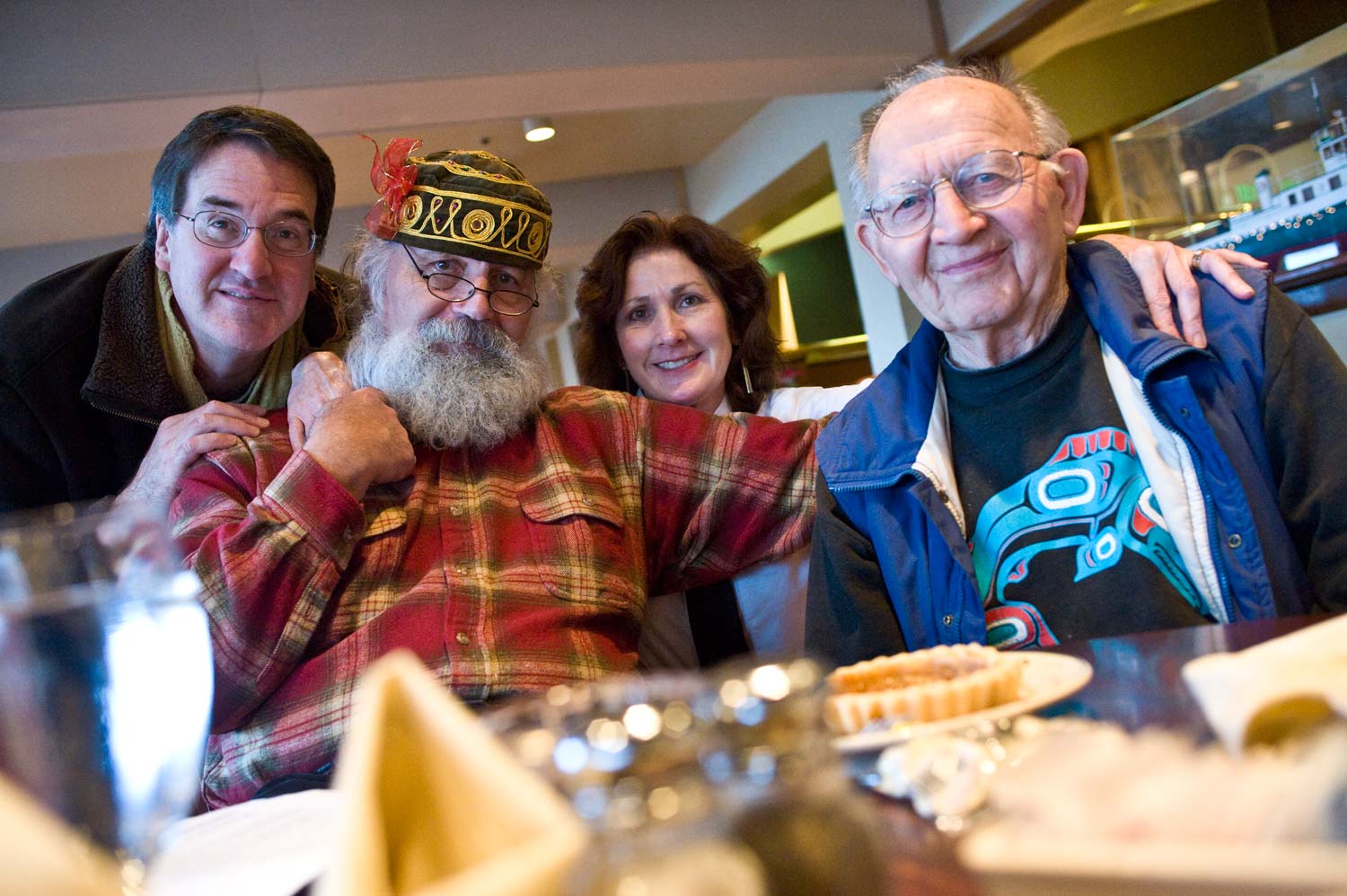
Seattle Now & Then: Built Around the Organ

(click to enlarge photos)

THEN:  Seattle Architect Paul Henderson Ryan designed the Liberty Theatre around the first of many subsequent Wurlitzer organs used for accompanying silent films in theatres “across the land”.  The Spanish-clad actor-dancers posed on the stage apron are most likely involved in a promotion for a film – perhaps Don Q, Son of Zorro (1925) or Douglas Fairbanks’ The Gaucho (1929) that also played at the Liberty.  (Courtesy Lawton Gowey)
THEN: Seattle Architect Paul Henderson Ryan designed the Liberty Theatre around the first of many subsequent Wurlitzer organs used for accompanying silent films in theatres “across the land”. The Spanish-clad actor-dancers posed on the stage apron are most likely involved in a promotion for a film – perhaps Don Q, Son of Zorro (1925) or Douglas Fairbanks’ The Gaucho (1929) that also played at the Liberty. (Courtesy Lawton Gowey)
NOW:  The curving glass curtain on the west façade of the new Fifteen Twenty-On Second Ave. building can be seen to “repeat” somewhat the symmetry of the Liberty’s proscenium arch.  (photo by Jean Sherrard)
NOW: The curving glass curtain on the west façade of the new Fifteen Twenty-On Second Ave. building can be seen to “repeat” somewhat the symmetry of the Liberty’s proscenium arch. (photo by Jean Sherrard)

In the now 55 years since the Liberty Theatre was razed for the big snuggery of parked cars across First Avenue from the Public Market, a few oil-stained stalls have taken the places of the Liberty’s 1600 seats.  “The only theatre built around an organ!” Is how popular organist Eddie Clifford described the Liberty in 1954, which was forty years after it opened as one of the first big theatres built in Seattle for movies rather than some mix of film and variety.

The organ sat front-center – as you see it here – and from its seat some of the best players of its silent film glory days accompanied the films. Half-hidden behind the grills to the sides and above the grand and gilded proscenium arch that framed the movie screen were the pipes and special machines the made the romantic Wurlitzer sounds, and effects like cooing doves, marimbas (you could see the hammers through the grill), canary trills, the sound of surf, and much more. The tallest pipe – 32 feet – was removed for repairs when its dangerous vibrations cracked the plaster.

In 1929, only the 15th year of its joyful noisemaking, the Wurlitzer was quieted as the talkies took over and the screen was widened.   Still depression-time attendance was good as management bucked Hollywood’s price policy with its own “New Declaration of Independence” that announced a reduction in ticket prices.  The theatre prospered.  In 1937 some press agent figured that “if all the money the Liberty has made was laid end to end it would stretch from here to a point twenty-seven miles southwest of Honolulu” – thereby floating a vision of great prosperity with one of a tropical vacation.

While planning to widen the screen for Cinemascope in 1955, management changed its mind and razed the Liberty instead complaining that there were “not enough good films” but plenty of cars needing to be parked.  It did not think to revive the Wurlitzer for a new era of silent films – something that is happening now in other venues.  The organ was first saved – 15 truckloads – by the music department at Pacific Lutheran University. Now it is at home at Spokane’s First Nazarene church, where it has its own activist chapter of the American Theatre Organ Society.  One of the highlights of the American Theatre Organ Society 2010 convention this summer in Seattle will be a cross-state bus excursion to Spokane and the Liberty’s born again Wurlitzer.

WEB EXTRAS

Jean contributes a somewhat wider view:

Liberty-Theatre-wide
Liberty's lot

Anything to add, Paul? You might at least compliment me on my double entendre in the caption.

YES JEAN WE HAVE SOME EXTRAS (& continue to click once and sometimes twice to enlarge)

But first our well wishes for you and your puns, may they be as supportive of you as a mother, for one good pun is as good as a mother.

We have more – four more photographs of the Liberty.  First another close look at your organ, followed by a wide angle of another production and unidentified too! (something for our reading experts to ponder), followed by another mystery, ushers or performers, we do not know which, posing with an unexplained sign on the sidewalk in front of the Liberty Theatre, and finally a night shot with a happy crowd (we know) gathered to see what that blessedly egalitarian encyclopedia that is written and checked by enthusiasts identifies as “the second talkie photographed entirely in Technicolor.”   The blessed media is, of course, Wikipedia, and the film “Gold Diggers of Broadway”.

The LIberty Theatre stage with a scene of passion not identified and its famous organ too.
The Liberty Theatre stage with a scene of passion not identified and its famous organ too.
The Liberty's showy stage from the back of the theatre for another unidentified production.  We may remind readers who last last weeks insertion on the Swedish Baptist Church that like it the Liberty Theatre was designed by architect Henderson Ryan.
The Liberty's showy stage from the back of the theatre for another unidentified production. We may remind readers who visited last week's insertion on the Swedish Baptist Church that like it the Liberty Theatre was designed by architect Henderson Ryan.
We don't know, but it is on the First Avenue sidewalk  in front of the Liberty Theatre looking north.  What is the last time you made it to a movie that was so appointed?
We don't know, but it is on the First Avenue sidewalk in front of the Liberty Theatre looking north. When was the last time you made it to a movie that was so appointed?

Liberty-nite-1929-WEB

A happy crowd gathered in front of the Liberty Theatre for Gold Diggers of Broadway sometime after its Aug. 30, 1929 release.  This, of course, is only weeks before the great economic crash-panic that began that fall and lingered to the Second World War.  So the film’s enduring hits “Tiptoe Through the Tulips” and “Painting the Clouds with Sunshine” were not composed as diversions or compensation for the Great Depression, but would soon serve so.

Gold Diggers was a hit – “one of the ten best films of 1929” as rated then by Film Daily. Wikipedia concludes “Contemporary reviews, the soundtrack and the surviving footage suggest that the film was a fast-moving comedy, which was enhanced by Technicolor and a set of lively and popular songs.  It encapsulates the spirit of the flapper era, giving us a glimpse of a world about to be changed by the Great Depression.”   To conclude and to repeat the historical point that was noted in the introduction to these four “extras”, Gold Diggers of Broadway was the second talkie photographed entirely in Technicolor.

Gold Diggers poster

Blogaddendum – Snow of Feb.1, 1937

Feb. 1, 1937 clipping from unidentified Seattle paper - Times, P-I, or Star.
Feb. 1, 1937 clipping from unidentified Seattle paper – Times, P-I, or Star.
Flip side of the same clipping - 2/1/37
Flip side of the same clipping – 2/1/37

This found fragment may be a reminder that February has typically been our cruelest month, and it is yet a week away, and looked to now from the warm days that have some camellias opening their red blooms early.   A reading of the preserved part of the story above reveals that Olympia had 19 inches, Lake Union had a sheet of ice on it although nothing one could walk upon, Portland was stuck in every way, the farmers in the vicinity of Spokane continued to be isolated from supplies and markets, that Seattle’s birds needed some food thrown their way in such a way that it is not buried by the snow, and that – showing at the bottom of the left column – something has happened to 53-year-old W.M. Littleton.  But what?  Perhaps some reader will get to the U.W. Library or the Seattle Public Library and search through microfilm for  the Feb. 1 1937 issues for The Seattle Star, the Seattle Post-Intelligencer and The Seattle Times and share with us Littleton’s predicament or fate.  It might be wise to start with The Seattle Times, then still an afternoon paper.

(We will insert this into our History of Seattle Snows,  Part 6.)

A Wallingford Camellia from Jan. 20 last.
A Wallingford Camellia from Jan. 20.

Paramount – The Old Sign

Nine years ago, perhaps, after leaving the library at its temporary quarters on Pike, I took this photograph of the Paramount and its old sign warmed by a late-afternoon winter sunset.  The old sign may be compared to Jean's recent record of the new sign that replaced.  It is just below and part fo the Swedish Baptist insertion.
Nine years ago, perhaps, after leaving the library at its temporary quarters on Pike, I took this photograph of the Paramount and its old sign warmed by a late-afternoon winter sunset. This old sign may be compared to Jean's recent record of the new sign that replaced it, which is included just below as part of the Swedish Baptist feature.

Seattle Now & Then: The Swedish Baptists

(click to enlarge)

THEN: The Ballard Public Library in 1903-4, and here the Swedish Baptist Church at 9th and Pine, 1904-5, were architect Henderson Ryan’s first large contracts after the 20 year old southerner first reached Seattle in 1898.   Later he would also design both the Liberty and Neptune Theatres, the latter still projecting films in the University District. (Photo courtesy Lawton Gowey)
THEN: The Ballard Public Library in 1903-4, and here the Swedish Baptist Church at 9th and Pine, 1904-5, were architect Henderson Ryan’s first large contracts after the 20 year old southerner first reached Seattle in 1898. Later he would also design both the Liberty and Neptune Theatres, the latter still projecting films in the University District. (Photo courtesy Lawton Gowey)
NOW: High rises continue to advance on the parking lot that took the place of the Swedish Baptist Church in the early 1970s. (Photo by Jean Sherrard)

When Seattle became a boisterous “boom town,” especially following its “great fire” of 1889, the immigrant Euro-American communities that fed the growth rarely created neighborhoods of size that were clearly theirs.  However, they could organize churches and did.

The Swedish Baptists are an example. Organized as a mission in 1881 for a Seattle of about five thousand, it was “instituted” in 1889 for a community of over 30,000.   A stately if typical frame sanctuary with soaring steeple was built on then still affordable land at Olive Way near 5th Avenue.   Fifteen years more and the ballooning opportunities of land values moved the congregation five blocks east into this spectacularly towered church of pressed brick and stone at the northwest corner of 9th Avenue and Pine Street.

At its dedication on July 16, 1905, addresses were given in both Swedish and English.  Thirty years later, Dr. Emil Friburg, by then its pastor for 24 years, announced to his congregation that Sunday evening services, which for 55 years had been given in Swedish, would from then on be delivered in English only.  The immigrant’s children, of course, were not so disappointed.  Raised in Seattle and its public schools – more than in the church – their principal language was English.

In 1970 the congregation sold its corner to the Vance Corporation, which given the then slumping economy probably got a deal.  It has, I believe, been a parking lot ever since.  Many of the church’s members and assets joined with Seattle First Baptist on the northern “ledge” of First Hill.

WEB EXTRAS

At the opposite corner stands the Paramount Theatre, newly signed.  Its beautifully wrought fire escapes remain unchanged.

The Paramount Theatre
Fireoglyphs
Fireoglyphs

Anything to add, Paul?

Yes Jean, here’s something we might call . . . CAN YOU FIND THE SWEDISH BAPTISTS? Remember Jean to click to enlarge.  It will help you find the Baptists. 

Cap-Hill-fm-NewWhtl-'11-WEB

Here we look west towards a Capitol Hill horizon from the nearly new New Washington Hotel, still standing at the northeast corner of Second and Stewart although long since renamed the Josephinum.  The Swedish Baptist Church at its new location, the northwest corner of 9th Avenue and Pine Street, appears here left-of-center.  It can be best identified by the shine of its tower arches.  They are small from this distance but still sparkle. Beginning in this scene at 5th Avenue, Pine Street cuts across the scene from its bottom-right corner.   Some of Olive Way appears on the left.

The likely date for this is 1911 (but possibly 1910), for the rear unadorned facade of the Seattle Electric Company’s new administration building appears far left at the southwest corner of 7th Ave and Olive Way.  See how the fresh sidewalk on Olive Way shines at the base of the new headquarters.  The same company’s old trolley car barn is to this side of 6th Avenue.  The new – since 1906 – cut of Westlake is twice evident: in both the bottom-right and bottom-left corners.  Broadway High School at Broadway and Pine just touches the horizon, left-of-center.   Also up there, but not reaching the horizon, is the wide west facade of Summit School, right-of-center, at 1415 Summit Avenue.  It is still in use as Northwest School.

Digital Montage – 1 Multiplied to 16,384

Drops-on-TEAR-bit-WEB

[Click Once and Often Twice to Enlarge]

Below is the “base.” It is a detail from a neighbor’s bush that was planted as a screen between the sidewalk and the small house, which is one of the few in Wallingford that has gone vacant because of the burst bubble.

The bubbles – on the leaves – where photographed on an afternoon in the first week of January 2010.  Above is a detail from the same plant – or long young hedge – which was chosen because of its “scar.”  I use it as a detail in the montage that follows in order to break the regularity of it all.  (I see now that I appear hugging my camera in the biggest bubble.)  When I learn the more sophisticated powers of “Photoshop Layers” there will be more and less regular opportunities for introducing asymmetry into these montages.

Over the past three years I have done scores of these.  Much more than snowflakes they are all very different.  And they are all in process – often waiting for irregular and pleasantly confusing layers.  In four years of walking the neighborhood almost everyday I have “collected” a large library of subjects that were “captured” for these purposes.  Most of the bases are natural and photographed as found, like this one,  but a few others I have prepared by arranging sticks and flowers and such with an eye to how they will multiply.  But this multiplication is so transforming that really anything will bring forth modest and always, I think, stimulating revelations.  As you will note below the more you multiply through successive flip-flops these designs the more they head march towards texture.  With one more generation below we have a fabric suitable for a men’s sports coat (at 16,276) and with two more (as yet not rendered) perhaps a formal suit for wearing in tolerant society (65,104).  All of them from rain-splattered leaves on an unidentified bush.

Below the scar are the multiplications.  The first is a quartet.   From there we flip and flop and  jump to 4, 16, 64, 256, 1,024, 4096 and 16,384.  All have been layered with an asymmetrical piece copied and itself multiplied or flipped (or perhaps flopped) from the detailed “scar” at the top.  No. 256, especially, may be imagined as a quilt or a ceiling.  Some of this shares the pleasure of making quilts and even knitting – although it is much quicker.  Perhaps 65,104 will follow in a moment more idle than this.  If it is brought up it will seem to be nearly pure texture in which the parts cannot be seen clearly and are imagined to be in a chaotic distribution rather than arranged.  I think.  “All will be revealed.”

BASE
BASE
Drops-4-plus-WEB
4
16
16
64
64
256
256

drops-1024-verylr-WEB

1024

drops-4,009-VVverylr-WEB

4096 /  This 4096 montage may serve as an hour glass for me – a “Time Remaining” calendar that encourages me to not waste time.  Now 71 I could treat the above as a check-off list for time left – if I live as long as my two oldest brothers Ted and Norm and my father Theodore.  All three lived to within months of 80.   If I count everyone of the gray “hour glasses” in the montage above as representing three days, then I may there both purview and preview the sum I have remaining for abiding here in this often enough happy veil of tears, but only if I am as fortunate as the others and do not stumble into some misery that I would rather escape than abide.

drops-16,384-lres-WEB

16,384

Seattle Now and Then: A Wallingford Restoration

4719 Thackeray Place NE.  The 1938 WPA tax photo.
4719 Thackeray Place NE. The 1938 WPA tax photo. (Courtesy Washington State Archive, Bellevue Community College Branch)

Here’s a happy story now increasingly told throughout Seattle.  The names and places vary but the story is the same, and restoration is always in the title.

In this instance Claudia Levi purchased the Wallingford home seen in the second photograph (below), with a mind to restoring it.  She looked no further than the 1937-8 tax photo, printed on top, to determine what her home almost certainly looked like in 1909 when it was built.  Some of the original details were hidden under a cedar cladding that had been added in an effort to “modernize.” Other parts had gone missing, but after three summers of work Claudia Levi had her new old home.

What the house looked like in 1997 soon after Claudia purchased it.
What the house looked like in 1997 soon after Claudia purchased it. (photo by Claudia Levi.)

Certainly it helped that as a member of the Business Faculty at Edmonds Community College, Ms Levi had economic savvy.  And in compliment to her restoration project she also taught a class in using salvage material to rebuild houses.

Claudia Levi’s 1937 evidence (top) comes from the Washington State Archive’s WPA survey of taxable structures from the late 1930s. There is a good chance that Pacific readers living in good old homes that have been altered will find their home “as built” in that collection.  Contact archivist Greg Lange at 425 564 3942, and have your home’s tax number or legal description (addition, block, lot) ready.   Prepare to restore.

A restored 4729 Thackeray Place during the summer of 2009 with a front porch crowded by friends celebrating its centennial.
A restored 4729 Thackeray Place during the summer of 2009 with a front porch crowded by friends celebrating its centennial. (This photo and the others not marked recorded by Paul.)
From left to right:  * On the left riser: Dick Barnes behind the balloons, Candy Barnes, and Claudia Levi  * On the steps clockwise starting left top:  Meg Pasquini, Gina McManus, Andy Williams, Brian McManus, Mazie McManus, Charlie McMansu and Gisela Levi  * On the right riser from top to bottom:  Jane Shapira, Cynthia Williams, Shaun Darragh, Chris Way, and Sam Miller
From left to right: * On the left riser: Dick Barnes behind the balloons (see the bottom), Candy Barnes, and Claudia Levi * On the steps clockwise starting left top: Meg Pasquini, Gina McManus, Andy Williams, Brian McManus, Mazie McManus, Charlie McMansu and Gisela Levi * On the right riser from top to bottom: Jane Shapira, Cynthia Williams, Shaun Darragh, Chris Way, and Sam Miller

Now the owner-restorer, Claudia Levi, (second from the right, below) adds her own testimony to the joy and work of restoration.

I bought 4719 Thackeray Place NE  in 1996.  Well, it was really ugly! All of the beautiful exterior trim and detail was removed or boarded over and it endured so for about 50 years, from the 1940s to 2000 when I had it restored to its original facade.

This was a beautiful house when it was built in 1909 and it was pretty much as built still in 1937.  After 1940 it lost a lot of its original charm in order to “modernize” for a “cleaner” look. The family that had the house from 1940 to 1992, was the longest consistent resident in the home, and they made a lot of the changes to the house.

One can see in the 1996 photo that the top half of the house was boarded over with dark cedar boards, and all of the original street-side windows were modernized.  They put a big picture window downstairs and made the upstairs window smaller to accommodate a big bed under the window.  The two oval windows on the sides of the second floor were simply boarded over.  Well just about everything was boarded over.  I am sure this was done for a heat savings.  It was considered “progress.”  All of the beautiful trim on the inside was also removed.   To restore its original charm the entire home needed work.

As part of the “young-over-zealous homeowner movement” of the 90’s and early 00’s, I brought the house back to its original charm removing its cedar mask.  Through multiple visits to ReStore (1440 NW 52nd St Seattle 206-297-9119) and Second Use Building Materials (7953 Second Ave. S.  Seattle 206-763-6929) the house regained its original exterior look, similar to 1909.  This included replacing both large windows, a new stucco job on the second floor exterior, and a four-color paint job.  There was an extensive interior restoration completed as well during this time.  The house will surely live another century to outlive me – and well you too!

Happy Birthday, 4719 Thackeray Place!  Wishing you another 100 years and more!

In the back yard, left to right:  Meg Pasquini, Jane Shapira, Claudia Levi and Gisela Levi
In the back yard, left to right: Meg Pasquini, Jane Shapira, Claudia Levi and Gisela Levi
A page from Claudia Levi's restoration journal - with timeline.
A page from Claudia Levi's restoration journal - with timeline and Claudia's forefinger.
Concluding with nearby neighbor Dick Barnes no longer behind the balloon.
Concluding with nearby neighbor and raconteur Dick Barnes out from behind the balloon.

Seattle Now & Then: "Testing Cedar River Water"

(click to enlarge photos)

THEN:Carolyn Marr, Museum of History and Industry librarian and Anders Wilse expert, answers the joking caption on Councilman Reinhard’s pant leg with another example. “Wilse had a wry sense of humor. In one photo he took during the Great Northern Railroad construction project, a group of 4 men sit around a table playing cards with revolvers and glasses of liquid. He wrote on the photo ‘A Merry Christmas.’”  (Courtesy Seattle Municipal Archive)
THEN: Carolyn Marr, Museum of History and Industry librarian and Anders Wilse expert, answers the joking caption on Councilman Reinhard’s pant leg with another example. “Wilse had a wry sense of humor. In one photo he took during the Great Northern Railroad construction project, a group of 4 men sit around a table playing cards with revolvers and glasses of liquid. He wrote on the photo ‘A Merry Christmas.’” (Courtesy Seattle Municipal Archive)
NOW: Author-editor and friend Clay Eals accompanied Jean Sherrard to the new Queen Anne Standpipe to take Reinhard’s place.  Clay is drinking Cedar River water drawn from his own tap. Above him is 2 million more gallons of it.  (photo by Jean Sherrard)
NOW: Author-editor and friend Clay Eals accompanied Jean Sherrard to the new Queen Anne Standpipe to take Reinhard’s place. Clay is drinking Cedar River water drawn from his own tap. Above him is 2 million more gallons of it. (photo by Jean Sherrard)

For more than thirty years I have included this Anders Beer Wilse image in slide shows.  It always amuses.  Typically, I explain to those in attendance “Here are two members of the Seattle City Council ‘testing Cedar River Water’.” They answer with incredulous variations of “Oh really!”

“Testing Cedar River Water” is written clearly across the pants of the one tipping the bottle.  Who is he, where is he and when?  I did not know.  But now with a little help from friends and fellow heritage travelers I do and it can be told.

Anders Wilse was hired in 1899 by Seattle Public Works to photograph work-in-progress on the Cedar River gravity system.  Anne Frantilla, Seattle’s Deputy City Archivist, notes that the Norwegian photographer’s negative number “80.x” is also written on a pant leg. Deducting from other numbered Wilse negatives and also from news clippings of the city council’s long tour itinerary for this Tuesday, we may conclude that our two “inspectors” are joyfully lifting their arms on top of Queen Anne hill beside its then new standpipe.  It is early in the afternoon of May 1, 1900.

Using group photos and newspaper election-time mug shots Jodee Fenton and Carol Lo of the Public Library’s “Seattle Room” have identified these two transplanted Oregonians as the newly elected Scott Benjamin on the left and the third term councilman William V. Rinehard tipping the bottle – but a bottle of what?

Fred Cruger and John Cooper, two antiquarian beverage experts, think they know, and independently.  That is a long-necked, foil-capped bottle of a malt-extracted low alcohol drink that Rinehard is sampling. It was promoted as healthful, and new mothers were advised to use it to enrich – or fortify – their breast milk. Consequently, it was most likely not pure Cedar River water, which was still months from reaching Seattle, that councilman Rinehard was chugging.

Seattle Community Water – A History to ca. 1996

(Please Click once and then CLICK AGAIN to enlarge.)

The most likely near-beer toast to Cedar River Water shown and described above is one joyful moment in the history of Seattle’s efforts to have clean water beyond fetching it with a bucket from streams and/or the springs that once flowed from First Hill and have since been redirected into the city’s sewerage system.  The limiting date here – ca 1996 – is “confessed” because what follows, with a few small exceptions, is copied from the Building Washington, A History of Public Works that Genny McCoy and I wrote and published in the 1990s.  We worked on it for about eight years, and were rewarded with The Governor’s Writers Award for 1999.  (Imgaine, the governor hugged us before about 100 admiring book lovers.)  Of course, much has happened with Seattle’s waterworks since 1996 (or so) but you will not find that below.   Ron Edge – of Edge Clippings – has been speculating or murmuring that perhaps we should make a PDR file out of the entire book.  If so we could then try some updates for the subjects – like this one.  (One can also check historylink.org and see how they have developed this story.)  Some of the photos included here were scanned from the book, others from negatives.  It should be obvious which are which.  We will begin with Seattle’s first two photographs, which are also waterworks related.  This is explained in their captions copies here directly from the book.

Yesler-Home-1859-60-WEB

HISTORY of the SEATTLE WATER DEPARTMENT to ca.1996.

Seattle’s first Euro-American settlers picked Alki Point for its proximity to salt water, not fresh. From the Point they could see in all directions and there was also a security in being easily seen -especially by other Midwesterners searching for homesteads. But the spit was dry. Within a half year, most of Seattle’s original pioneers fled across Elliott Bay to a hill sprouting with springs. The generous hydraulics of their second choice came from the aquifer that flowed below glacial hills and was replenished by the region’s reliable rain. This easy water helped convince Henry Yesler to set up Puget Sound’s first steam sawmill on Elliott Bay in 1853. (See Waterways Chapter – but for that you will need the book “Building Washington” for now.)

John Leary, a sometime partner of Yesler, was one of a group of local movers who first attempted in 1881 to build and organize an integrated distribution system. The Spring Hill Water Company diverted spring water into a dozen or so wooden tanks along the ridge between First and Beacon hills and laid some sizable water mains beneath the business district’s principle streets. However, the most auspicious moment for the future of community water that year was the September 25 arrival of Reginald H. Thomson. At daybreak the young teacher stepped from the steamer Dakota onto Yesler’s Wharf and was greeted by Yesler himself. Besides his baggage, Thomson carried ashore a predisposition to public service and a fervent belief in the importance of fresh water. “Clean water and sufficient water is the life blood of a city,” he liked to say. “My father drilled that into me.”

In the year Thomson came to Seattle his cousin and host, city engineer F. H. Whitworth, advised the city council that the Cedar River was the best potential source for an abundant supply of pure community water. However, in 1881 the council’s interest in building a water utility was as remote as the recommended river, which flowed from Cedar Lake some thirty-five miles southeast of the city. The council chose to rely on the bubbling wells of Spring Hill instead. With the boom in Seattle’s population throughout the 1880s (and well beyond them) the company’s wells were not enough so it built a pumping plant on the west shore of Lake Washington (now the site of Colman Park), and began pumping lake water to its new Beacon Hill reservoirs in 1886.  Still the company could not keep up with the city’s requirements. When its delivery was much less than heroic on June 6, 1889, the day thirty-plus blocks of the business district burned to the ground city leaders responded.

The bust of R.H. Thomson looks down at the Headworks, which is the dam, for the city's gravity system.  It is still being constructed here.  The date is Nov. 14,1999 and A. Wilse was the photographer, as we was for many of the subjects included below.  His negative number for this is "48x".
The bust of R.H. Thomson looks down at the Headworks, which is the dam, for the city’s gravity system. It is still being constructed here. The date is Nov. 14, 1899 and A. Wilse was the photographer, as he was for many of the subjects included below. His negative number for this is “48x”.

For the price of $352,265.67 the city purchased Spring Hill’s system and the responsibility of supplying its 12,000 customers. The remainder of Seattle’s 42,000 citizens (in 1890) were serviced either from their own wells or by smaller water companies which the city utility eventually subsumed. Shortly after the fire destroyed most of downtown in 1889, Seattle Mayor Robert Moran hired Chicago waterworks engineer Benezette Williams to devise a plan for increasing the city’s water supply. Williams warned against relying on merely adding more pumps at Lake Washington. The lake was already showing signs of pollution. The new municipal utility installed another pump at Lake Washington anyway.  R. H. Thomson became city engineer, on June 1, 1892.  He forbade expansion of the Lake Washington plant and put his formidable will to the task of bringing Cedar River water to the city.

Interrupting the Black River for construction of a trench to hold the pipeline from the Cedar River.  Date is Oct. 13, 1999. by Wilse
Interrupting the Black River for construction of a trench to carry the pipeline from the Cedar River below the Black River. Date is Oct. 13, 1999.  Seventeen years later the Black River was eliminated with the lowering of its source, Lake Washington. by A. Wilse

During the summers of 1893 and 1894 Thomson and an assistant made several trips on the night train to Maple Valley. There they unrolled their beds in the woods and rose with the light to tramp along the line of Benezette Williams’s proposed gravity line. Persuaded that Williams’s plan for an open V-shaped flume was “very bad engineering” as well as unsafe and unsanitary, they rough-sketched a route for a buried pipeline. However, Thomson’s plans were soon buried below the hard times of the Panic of 1893. Two years later relief came from an unexpected source.  Funding problems were resolved after the state Supreme Court approved the city of Spokane’ s proposal to rebuild its water system with revenue bonds redeemed solely through water utility receipts and not from the city general fund. Using the Spokane model, Thomson and his assistant, George Cotterill, wrote an ordinance for a Cedar River system to be paid for by revenue bonds. The new bonds, however, required voter approval. A contemporary characterized the election that followed as “waged with a fury scarcely equaled in any other campaign that the city has experienced. ”

Support for Thomson’s plan came from a combination of Progressives and Populists. The opposition was led by eastern capitalist Edward Ammidown.  Allied with several prominent Seattle businessmen Ammidown incorporated the Seattle Power Company and proposed to build a Cedar River system that would then sell its water to the city. The well-funded privatizing forces hired bands and speakers and hurled accusations of socialism at the public utility advocates. Federal judge J.J. McGilvra, a Lincoln appointee and respected Seattle civic leader, published a letter in the Post-Intelligencer supporting Ammidown’ s plan and urging a nay vote on city owner­ship. This apparent setback set the stage for Thomson’s strategy. Pioneer Seattle historian Clarence Bagley noted Thomson’s “masterful fighting” qualities, and the engineer’s assistants said he hunted “with a rifle, not a shotgun.”

Laying the water main on Broadway Avenue - somewhere.  This photograph is a puzzler and so yet to be unraveled.  This line is described as connecting the low reservoir on Capitol Hill with the Standpipe on Queen Anne Hill.  Since the pipeline bertween them ran on Harrison Street, which is but three blocks north of the north border of the reservoir on Denny Way.  Perhaps this is, then, part of that three blocks on Broadway although for 1899 it seems, to me, not as developed as I would have expected.
Laying the water main on Broadway Avenue – somewhere. This photograph is a puzzler yet to be unraveled. This line is described as connecting the low reservoir on Capitol Hill with the standpipe on Queen Anne Hill.  The pipeline between them ran on Harrison Street, which is but three blocks north of the north border of the reservoir on Denny Way. Perhaps this is, then, part of that three blocks on Broadway although for 1899 it seems, to me, not as developed as I would expect. And yet there is very little in the way of photographic evidence from that early.  A clue: judging from the shadows this recording of Broadway was taken looking south in the morning.  Those two large homes on the right surely would have survived for a few years more before being sacrificed for commercial structures on a commercial trolley-served street.  Another point: many of the earliest commercial structures were simply storefronts added to the fronts of home, facing the sidewalk, single story boxes where once there was a yard and/or front porch – of sorts.

Thomson set his sights on McGilvra. After several meetings with the city engineer, the judge ten days before the election wrote a second letter to the P-I, calling for approval of the bond issue. McGilvra then paid for the bands and speakers supporting public water. The combination of populism and respectability won the day with 2,656 votes for the measure to 1,665 against. As Thomson’s assistant George Cotterill later noted, “What we accomplished here in 1895 …within a few years every state did the same. Hundreds of millions of utility bonds were issued, interest rates were lowered, and utility bond investment was among the safest and most desirable.”

When Thomson and Cotterill emerged from the Cedar River watershed with their completed surveys in 1897, the city was alive with the stimulating effects of the Klondike Gold Rush. The following year the city acquired Landsburg for the site of its supply intake. (Shown above with Thomson’s portrait.)  The timber-crib dam there was constructed on concrete piers set at an elevation of 536.4 feet, a head high enough to carry water by gravity twenty-eight miles to the city reservoirs at Volunteer and Lincoln (Broadway Playfield, Carl Anderson Park) parks on Capitol Hill. From the headworks the water was delivered a few hundred feet downstream through a 54-inch pipe to a settling basin where the flow passed through screens, initially operated manually, to remove coarser materials like sticks and leaves. Over twenty-two miles of the pipeline were constructed of wood staves bound with threaded steel bands of the latest design.

Testing the pressure on the main built along (and eventualy under) Harrison Street (shown here) between the lower (of two) reservoir on Capitol Hill and the standpipe on Queen Anne Hill.  This view is dated Sept. 8, 1899. Negative 26x by Wilse.
Testing the pressure on the main built along (and eventually under) Harrison Street (shown here) between the lower of two reservoirs on Capitol Hill and the standpipe on Queen Anne Hill. This view is dated Sept. 8, 1899. Negative 26x by Wilse.

On the first of May 1900 the Seattle City Council made an all-day inspection tour of the system’s facilities.  The paused in Volunteer park for lunch on tables, inspected the work underway there on the high reservoir, and then proceeded to Queen Anne Hill for a look at the standpipe there.  As we know from the top, two of them also at least pretended to test the Cedar River water while visiting the standpipe.  They then went on to Kinnear Park to study its rustic mushroom and rest on the grass.

May 1, 1900.  City Council pauses at Volunteer Park.  R.H. Thomson is far right.  Wilse neg. 74x.
May 1, 1900. City Council pauses at Volunteer Park. R.H. Thomson is far left. Wilse neg. 74x.
Wilse's Neg x73 shows City Council in Volunteer Park moments earlier.
Wilse’s Neg x73 shows City Council in Volunteer Park moments earlier.
Standing in a study line withn the Volunteer Park reservoir's construction zone, the members have spread themselves out for distinction.  Wilse, again on May 1, 1900.
Standing in a sturdy (or studied) line within the Volunteer Park reservoir’s construction zone, the members have spread themselves out for distinction.   And R.H. Thomson has again put himself at the end, far left. Wilse, again on May 1, 1900.
The base of the Queen Anne Standpipe on Sept. 13, 1999.  by Wilse.
The base of the Queen Anne Standpipe on Sept. 13, 1899. by Wilse.
Construction on the Queen Anne Standpipe as of Jan. 26, 1900. by Wilse.
Construction on the Queen Anne Standpipe as of Jan. 26, 1900. by Wilse
Queen Anne Standpipe on Feb. 22, 1900.  by Wilse. Neg. 61x.
Queen Anne Standpipe on Feb. 22, 1900. by Wilse. Neg. 61x.
The Standpipe on May 1, 1900 inspected by the Council. by Wilse
The Standpipe on May 1, 1900 inspected by the Council and by Wilse.
Once more our two happy council members "testing" the water.  For names and more speculations see the now-then feature at the top.
Once more our two happy council members “testing” the water. For names and more speculations see the now-then feature at the top.
The Council in the rustic fields of Kinnear Park and its "mushroom."
The Council in the rustic fields of Kinnear Park and within the influence of its “mushroom.”
City Council taking a well-earned break from inspecting on the lawn at Kinnear Park, May 1, 1900.  by Wilse
City Council on the lawn at Kinnear Park taking a well-earned break from the rigors of inspecting, May 1, 1900. by Wilse.

On Christmas Eve, 1900, the system tested so satisfactorily that on ]anuary, 10, 1901, the waters of the Cedar River were let loose into the Volunteer Park reservoir. After a decade of riotous development, during which Seattle’s population grew from 80,000 in 1900 to nearly 240,000 in 1910, a second pipeline, which paralleled the first, was added in 1909. With the two mains the Cedar system capacity increased to 67,269,000 gallons a day. Two additional city reservoirs with a 110 million-gallon combined capacity were also built atop Beacon Hill.

Another testing of the main - but where?  The date is Jan. 12, 1900.
Another testing of the main – but where Wilse does not indicate? The date is Jan. 12, 1900.

In 1928 the Seattle utility began diverting Cedar River water to the 500-acre Lake Youngs (formerly called Swan Lake and named for Water Superintendent L. B. Youngs), seven miles west of Landsburg, for settling and storage. The following July Seattleites complained about the taste when the heavy summer draw lowered the lake level and raised its temperature. Eventually, a pipeline was added, which allowed the utility to bypass the lake when the river waters were cool and clear and did not need settling. From Lake Youngs, water was sent through the system control works where it was screened and chlorinated before being deliv­ered to its users.

In 1923 the city completed a third Cedar River pipeline that ran parallel to the first two. A fourth line was dedicated in 1954. Its path was entirely separated from the first three lines, in part as a precaution against any disasters that might sever the triad of pipes that ran through Renton and up and along the ridge of Beacon Hill to the city reservoirs. The fourth Cedar River line, or the Bow Lake Pipeline as it was originally called, entered the city from the southwest after running west from the control works to near Bow Lake in the neighborhood of Sea-Tac Airport.

The West Seattle Bridge with the primary supply of Cedar River water to the West Seattle neighborhood running across it through the pipe on the right of the trolley photo on the left.  On the right, an aerial of the Roosevelt neighborhood reservoir with a touch of east Green Lake at the top.

Getting water to Alki Point and the rest of West Seattle was still a problem sixty years after most of the first settlers left. West Seattle was annexed in 1907, following proclamations that the two communities were “plainly designated by nature to form one community.” However, the Duwamish River, which at the time was being developed into the Duwamish Waterway, inhibited the transport of Cedar River water to the annexed neighborhoods. The swing bridge over the Duwamish, built for wagons and trolleys in 1910, also carried the city’s main water lines to West Seattle. The effects on West Seattle plumbing were easily calculated. Whenever the bridge swung open for a boat or barge, the taps of West Seattle went dry. This intermittent service continued until the bridge was scrapped in 1918 and the mains submerged beneath the river’s traffic. The underwater solution was improved in 1924 when an 8-foot, concrete-lined tunnel was dug beneath the river and a steel main with walls three inches thick was laid within it. The desire for Cedar River water also figured prominently in Ballard’s annexation in 1907. In the “Shingle Capital of the World,” the campaign for “pure and sufficient water” was helped considerably when a dead horse was found floating in the Ballard reservoir on the eve of the election.

More water had to be crossed in the city’s extension of service to neighborhoods on the north shore of Lake Union. A pipeline from the Volunteer Park reservoir was run across the old Latona Bridge, which spanned the lake’s narrow neck to Portage Bay in line with the future 1-5 Ship Canal Bridge. Beginning in 1911 an extension of Cedar River Pipeline #2 was carried parallel to the Latona bridge on its own timber-pile span until 1916, when nearly 2,000 feet of 42-inch steel pipe were laid through a concrete tunnel built beneath the lake at the same passage.

The 1911 wash out of the Cedar River pipeline, on top, and the flooding of Renton from the same incident.
The 1911 wash out of the Cedar River pipeline, on top, and the flooding of Renton from the combination of heavy rain and the break in the main.  The bottom view looks west on Third Street from Burnett Avenue.  Renton High School is on the right.

In 1906 the City of Seattle made a widely unpopular decision to allow the Milwaukee Railroad to run its electric line to Snoqualmie Pass twelve miles through the lower Cedar River watershed. Five years later on the Sunday morning of November 19, 1911, the church bells of Renton called not for worship but for escape, sending its citizens scurrying for the hills. A warm Chinook wind released a downpour which swelled the river and undermined the bridge that carried the two Cedar River pipelines just down­stream from the Landsburg intake. The railroad construction along the river was determined partly responsible for making the pipeline’s own supports vulnerable. The collapsing bridge broke open both pipes, adding their volume to the already overflowing river and flooding the valley.

CapHil-tanktruk11-grabWEB

Summit Ave. looking north towards Republican Street intersection - now.

A water famine in Seattle followed. Citizens were encouraged to fill their bathtubs with lake and rainwater and the health commissioner’s precaution “BOIL YOUR WATER” blazoned across the front pages of the dailies. Since the limited supply in the city reservoirs was released only to the business district, entire families from more affluent neighborhoods fled their homes for downtown hotels. Schools closed for want of steam heat, and on Wednesday 2,000 bundles of Seattle’s dirty laundry were shipped to Tacoma. By week’s end water department crews had restored the pipelines.

In 1936 city officials applied for the water rights to build two reservoirs on the Tolt River. But it was almost twenty years later that the utility actually prepared to tap the river. In 1955, 650,000 people were being served by the Seattle Water Department. Water Superintendent Roy Morse-calculated that the Cedar River would be pushed to its capacity by 1970, and by 1980 about 900,000 people would be using the system. A second major source besides the Cedar would have to be used. Once the city council was convinced, it went ahead with development of the Tolt. In 1963 the river’s waters began flowing through the 25-mile Tolt River pipeline. As it turned out, Morse’s predictions were about right. In 1989 the Tolt and Cedar rivers together served over one million residents in an area whose size had grown to nearly 450 square miles. As parts of an integrated system, the two sources, plus a small amount pumped from the Highline Well Fields, could deliver up to 350 million gallons a day in 1990.

The Tolt line and beyond it the dam and behind it the reservoir.  Following this short history Jean has inserted our "then and now" from Washington Then and Now, which shows the Tolt reservoir when it was being cleared for filling, and Jean's repeat of it from 2005 (or was it 2006?).
The Tolt line and beyond it the dam and behind it the reservoir. Following this short history Jean has inserted our “then and now” from Washington Then and Now, which shows the Tolt reservoir when it was being cleared for filling, and Jean’s repeat of it from 2005 (or was it 2006?).

Seattle’s water system includes Bellevue, Kirkland, and Redmond, together with a number of other cities and water districts. Each community acts as a separate purveyor purchasing water from Seattle, the wholesaler, and reselling it within its service area. Although Seattle aggressively pursued water custom­ers to the north, the city had to be wooed for nearly thirty years to supply the Eastside. In 1937 Eastside residents petitioned the city council to allow them to connect into either the Tolt River or Cedar River lines. The construction ofa pipeline from the Cedar would have involved no insurmountable engineering obstacles. (The’Tolt waters were still a quarter century from being tapped.) But the Seattle City Council didn’t think there was enough population to support the service, and not even the prospect of $900,000 in federal employment grants persuaded them to build the connection.

Eastside residents themselves were ambivalent about requesting the gravity system to supplant their wells. In a 1939 election a new water district, which included Bellevue, voted 891 in favor and 899 against requesting Cedar River water. Seattle’s relaxed water department superintendent, W. Chester Morse, remarked, “Take as much time as you want. Every month’s delay saves this department over $15,000 dollars. We certainly are in no hurry.” Ultimately, the utility would change its mind as postwar growth brought increased water needs to the Eastside. Three years after he succeeded his father as superintendent in 1949, Roy Morse advised the city to speed its development of the Tolt River, in part to supply the Bellevue area. In 1963 that community came on line with the Seattle system’s new Tolt pipeline. Eventually, the Tolt Eastside supply line was connected with a new Eastside line laid from the Cedar River at the pump station in Bellevue’s Lake Hills district. In 1998 construction began at a 25-acre site overlooking the South Fork of the Tolt River on a filtration plant capable of filtering 120 million gallons of water a day when it opens in late 2000.

With the considerable population growth that occurred in King County by the 1980s, Seattle water department officials quickened their search for new sources of supply and their investigations into conservation methods. In 1985-86 the water department tapped its Highline Well Fields for a ready daily supply of 10 million gallons. Typically this new source was used only during the dry summer season when the average daily demand of 170 million gallons could rapidly inflate up to 300 million gallons. Restraining the public’s wasteful over-watering of residential lawns became the key to the utility’s development of a conservation program.

During the drought of 1987, the utility was forced to innovate when the level of Chester Morse Lake (Cedar Lake) dropped below the elevation of 1,532 feet – the minimum level for moving lake water by gravity. Department officials outfitted a barge with a pumping plant capable of moving nearly 120 million gallons a day from the lake into the lower-elevation pool behind City Light’s masonry dam from which it flowed into the system. The experience resulted in plans for installing a permanent on-shore version of the barge-mounted pumps. The Cedar Watershed is capable of supplying a volume considerably greater than that which it now delivers through the four Cedar pipelines. However, fish using the stream to spawn could be adversely affected, and new transmission lines would be needed if a permanent deep-water pump at Chester Morse Lake were to be useful year round. Two other possibilities for increasing supply are to add a filtration plant to the Tolt River system, making it usable during periods when heavy runoff makes the water turbid, and building a second intake on the river’s north fork.

However, even during the more severe drought of 1992, department spokesmen admitted that any such expansions were at least ten years away. In the meantime, Seattle and other Puget Sound area water departments and districts hurried work on their conservation plans as they implemented drastic conservation measures, such as a total ban on lawn watering. The reuse of treated waste water and the distribution of low flow shower heads were just two of the measures Seattle officials promoted as a way to save the 47 million gallons a day the department needed to conserve through the end of the decade.

Less than a month before the City Council's May 1, 1900 inspection, an unidentified group of Seattle-base (we assume) engineers were invited to inspect the project.  The date is April 9, 1900.
Less than two months before the City Council’s May 1, 1900 inspection, an unidentified group of Seattle-based (we assume) engineers were invited to inspect the project as well.  Yes R.H. Thomson is among them, and can you find him?  The date is March 8, 1900.

The following photo and its repeat directly below are one of the many comparisons Jean and I make in our book “Washington Then and Now.”  It is described in greater detail on its own webpage and also appears in the “store” we have buttoned on this blog

The Tolt River pre-dam, mid-50s
THEN: The Tolt River pre-dam, mid-50s
NOW: The Tolt in 2006

Jumping in Seattle (New Year's Day)

Queen-Anne-jump
Click to enlarge

Just after brunching at Queen Anne’s Five Spot Cafe with sound design supremo Jim Wilson (with whom I worked on 16 Stories of Chekhov a couple of decades ago), I visited Doris Chase’s 15-foot tall steel “Changing Form” – which Paul hazards is the most photographed sculpture in Seattle – except for, perhaps, the Fremont Troll.  This narrow strip called Kerry Park provides some of the best views in town.

And even on this wet New Year’s Day, a half dozen cameras were snapping away.  A couple of young women stood out for sheer exuberance: a jumper and her delighted photographer, glimpsed through the sculpture against the gray Sound and sky.

Happy Birthday (89th) to Richard, Happy New Years to All with 3 Bunnies in a Basket, Dec. 31 on the Blvd Haussman in Paris, Several Recommendations for NEW YEARS RESOLUTIONS! & One Unfinished Churchyard Story.

RICH BERNER of this blog is 89 today, Jan 31, 2009 and Jean and I treated him to lunch at Ivar's Acres of Clams - "Where Clams and Culture Meet" - on Pier 54 "At the Foot of Madison Street."  Jean is on the left, I'm wearing the ribbon in my hat, and Ivar's mainstay in posing with us too.
RICH BERNER of this blog is 89 today, Dec. 31, 2009 and Jean and I treated him to lunch at Ivar’s Acres of Clams – “Where Clams and Culture Meet” – on Pier 54 “At the Foot of Madison Street.” Jean is on the left, I’m wearing the ribbon in my hat, and Lisa, an Ivar’s mainstay, in posing with us too.  All that puts Rich on the far right.  (I think that is Lisa’s hand on Rich’s left shoulder – not mine.)

b'day-rich-WEB

(Click these cards once or sometimes twice to ENLARGE.)

Earlier on the 31st - because Paris runs 9 hours earlier than we in Seattle - Berangere took this look across the Blvd Haussmann to the rear facade of the Paris Opera House.
Earlier on the 31st – because Paris runs 9 hours earlier than we in Seattle – Berangere took this look across the Blvd Haussmann to the rear facade of the Paris Opera House.
This lavishly cute and sentimental card is about a century old, as are most of those that follow.
This lavishly cute – bunnies!!! – and sentimental card is about a century old, as are most of those that follow.
Now open door to a few resolutions that follow.
Now open your door to a few resolutions that follow. Some of these read like they were composed by Horatio Alger when he was a clerk for the Better Business Bureau in Peoria, Illinois.
Sunset if its the 31st and Sunrise if the 1st.
New  Years Resolutions as Prescriptions
New Years Resolutions as Prescriptions
More Horatio Alger as a developed marketing sensibility.
So true and so hard!
Flowers this First Morning

Bard-&-Preacher-Quart-WEB

Log-Cabin-pink-NYear-WEB

Must we always be productive?
May you treat these four cards as parts of an incomplete narrative - and finish it?
An Unfinished Churchyard Story.  May you treat these four cards as parts of an incomplete story – finish it and share it as a “comment.”
We wave again from the garden gate.  Happy 89th Rich.  Happy New Years Everyone.
We wave again from the garden gate. Happy 89th Rich. Happy New Years Everyone.

Happy New Year from BB!

(click to enlarge)

Lomont_004
Boulevard Haussman, taken tonight in Paris, with the rear of the Opera at center.

BB writes:

“…At least once a month, I want to photograph this little dome in color, but I’ve been working all month photographing romanesque chapels, day and night.

New Year’s Eve was my first day off.  I ran straight to the terraces on the 7th floor of the Printemps located on boulevard Haussmann.  From there, one can contemplate Paris and its magnificent 19th century domes; far from the crowded streets, we dream in a celestial field of buildings and monuments sculpted by light … Just before the new year !

Dear Ameer – Our 1902 Advance on Afghanistan

Here’s a double rarity for this media.  The attached is not from Ron Edge’s “clipping service” but from a microfilm reader at the U.W. Library.  The reason for sharing this page from the Jan 10, 1902 Daily Bulletin (a Seattle tabloid “devoted to Courts, Finance, Real Estate, Building and All Industrial Improvements”) is its clue to contemporary politics, which can be read directly below the part marked with a translucent red marker.  It expresses a sentiment that comes out of the joy of war got for Hearst and Roosevelt (representative citizens – pars pro toto – then for the nation) by beating up on Spain and the Philippines and so exhilarated the nation and brought such confidence that it was ready and eager for more broad-shouldered foreign jarring – or “big stick” jousting – in the name of “20th century progress.”  This was the first bloom and blush in the courtship of government and industry that soon gave birth to what we now call the “military industrial complex.”  Those that recall their world history will remember that 1902 was in the thick of the Age of Imperialism.  We never left it.

(Double click to Enlarge)

Afgan-Professy-Jan02-WEB

Up the Down Chimney, Part II

Thanks to all who attended one of our shows this year!  The first, at Town Hall, sold out the downstairs space and was a ripsnorter, indulging in oodles of spirited holiday fare.  The second, at the Good Shepherd Center Chapel, drew a more intimate 70 or so, but revealed its own candid pleasures.

Performers included Julie Briskman, Frank Corrado, Paul Dorpat, and Jean Sherrard, displaying a wide range of seasonal tonics, anecdotes, and antidotes. Musicians included John and Tia Owen, Mark Kramer, Stu Dempster, and Ethan Sherrard. We particularly thank our tech support staff – artists both – the always inspired David Verkade and Jean’s brilliant former student Rhys Ringwald.

Here are a few photos from both events:

Town-Hall-pan-WEB
Wier Harman exhorts the crowd at Town Hall
Frank Corrado reading 'Red Ryder nails the Cleveland Street Kid'
Jean with Julie Briskman singing "Christmas Island"
Jean with the remarkable Julie Briskman
Paul conducts
Dorpat conducts; Dempster's on his axe.
IMG_1874
Mark Kramer, John and Tia Owen, as the Town Hall show begins
Canon 2 046
Mark, John, and Tia
Mark Kramer
Mark Kramer
Quartet-Up-Down#1-WEB
John, Ethan Sherrard, Jean, and Stu
Paul reads Thurber (photo from Rhys Ringwald's cell phone)

Street Poet revisited

Vladimir Augustin near First & Main

Vladimir Augustin, whom some may remember from an April post, walked into John Siscoe’s Globe Bookstore, looking cold and a bit blurred around the edges.

He writes poems on cards for passersby and lives rough. For the most part, the tourist trade has dried up, but he carries a small boombox (which was playing a Mozart concerto), and continues scavenging for customers.

Needle postcard
Needle postcard

John gave Augustin a postcard of the Space Needle and when I found him in front of the soon to be evacuated Elliott Bay Bookstore, he wrote me another poem. It was night and hard to decipher under the streetlight, but he read it to me aloud. ‘A Masterpiece of Christmas’ he called it, and I’d share it with you but I can’t quite make out the script.

UPDATE:

As per Maria’s request, a photo of the postcard poem — ‘A Masterpiece of Christmas’ – note it contains an acrostic: “The Collective Purpose” (click to enlarge):

'A Masterpiece of Christmas'

Edge Clipping – READ ALL ABOUT IT – The Evening Dispatch for Monday Dec. 24, 1877

edge-clip-logo-1-web21

For the occasion of this Christmas 2009 Ron Edge has pulled out the full four pages of Seattle’s Evening Dispatch for the Monday Evening of Dec. 24, 1877.   For those with the steady temperament to insert themselves into a small community of well under 4000 citizens – and yet still with five churches and many more bars – a close reading of these pages will take them away.

The Dispatch was not the first newspaper in Seattle, but it was an early one.  Clarence Bagley, the pioneer Seattle historian described its editor, Beriah Brown, as “one of the old school of newspaper men, a writer of editorials worthy of the great papers of the United States.  He was a friend of Horace Greeley . . .  His custom was to go to the case and put his articles in type as he composed them. It is hard to comprehend the difficulty occasioned by the dual processes of thought this brought into play.”

We will include now all four pages of this Dec. 24, 1877 issue, and separate them by short notices of some of what we found on each page.  The reader may, of course, skip our comments and go directly to Brown’s Dispatch.

First – the first page.

In 1877, Christmas fell on a Tuesday.  This made the call for profound messages especially taxing on the small community’s several preachers.  They could not very well avoid the Christ Child with their Sunday the 23rd sermon, but they then would also be expected to come up with new materials, and roughly on the same subject, for Christmas Day services.  Rarely, of course, did they have “new material” but were skilled for the great part in the twisting or adjusting of the old stories – most of them from the Bible.  Still if you read the Page One Evening Dispatch accounts of some of Seattle’s Sunday services, you will find differences of tone or emphasis in how, for instance, Rev. D. Bagley of the “Brown Church” and Rev. I. Dillon of the “White Church” and visiting Congregationalist  Rev. W. Steward handle their subjects.  J. Ellis, the local Congregationalist, also took to the pulpit, Sunday evening.  (The Baptists, Catholics and Episcopal churches were noted in other reports.)

Of these four, it was Steward, the visitor from the north, who after warming up gave the best example of a fire and brimstone sermon noting that “commonsense, sound philosophy and our home experience unite, in tones of thunder, ‘that heaven is no place for the ungodly.  The very thought of the atheist, the Deist, the liar, the murderer or blasphemer going to heaven is absurd.  There is nothing so much out of place and unfit, that would be justified for a moment by any respectable tribunal on earth, much less in the court of heaven, where nothing that defileth or maketh a lie can enter, and where ‘Holiness if the Lord’ is the imprint on every commodity.”  Commodity!?    Jumping forward to page three, we learn that Steward when relaxing with a cup of tea in the living room is a kindly “84 years of age.  He is visiting with Dr. Weed, Mrs. Weed being his niece.  Mr. Stewart has been an extraordinarily temperate (non-drinking) man all his life, and consequently is now in the enjoyment of a serene, healthful and happy old age.”  (You will find an advertisement for Dr. Weed, Steward’s host, on page three below.)

It was Ellis, the other and younger Congregationalist, who was kinder to mankind – and progress too – with his sermon.  Ellis told his congregation “Well, one thing is assured: (The coming of the Christ Child) is not a bolt from far aloft shot athwart the pathway of the race to smite it and cut if off from its onward march.  Christ is not a force antagonistic to man – He is Man Himself.  He gets the momentum of humanity, casts himself into a stream of life and comes to the surface a Babe!”

Also on page one and nearly directly to the right side of Dillon’s sober description of mankind is Fred Gasch’s announcement that he will open his “New Beer Hall” on Front Street (First Avenue) next to the North Pacific Brewery, and so also near the waterfront foot of Columbia Street. And for joyful encouragement Gasch includes in his advertisement his own sermon, of sorts, a rhyming one in song.   It goes . . .

Come to the Fountain to-night, boys, / And fill with foaming beer. / What if your heads get light, boys, / The pleasure of life is here. / Eat, drink and be merry today, boys, / The old-time philosopher said, / Then go to the Fountain and stay, boys, / Till the shadows of the night have fled.

Compared to Gasch’s New Beer Hall, William Lawrence’s Office Saloon and Billiard Room might seem a bit swanky.  It was on the south side of Mill Street (Yesler Way) opposite Yesler’s Mill.  “It is the place to get genuine J.H. Cutter, Old Golden and Gaines’, Old Hermitage Rye Whiskies, Three Star, Hennesy, and Martell Brandies, and the Best Wines and Cigars; also to have a game of Billiards on a first-class table.  We have a number of private Club Rooms for accommodation of guests.”

One more mention for Page one.  The Seattle and Walla Walla Railroad is listed with a charming little graphic for the train, and a schedule for its Seattle-to-Renton runs.  Of course, not once did it make it as far as Walla Walla.

(Please DOUBLE-CLICK to enlarge to a readable size.)

dispatch-122477p1-web

Page Two

At the top of page two the Evening Dispatch’s editor, the crusading moralist Beriah Brown, with an editorial on “Political Fault-Finders” makes an analysis of Pres. Hayes administration’s failure, in spite of promises, to replace the spoils system with an apolitical civil service administration.  Page two is also stuffed with advertisements including one for the watchmaker, jeweler and engraver Charles Naher, who is also selling the “largest and best selection of Musical Instruments in the Territory and will be sold at reduced prices.  The public are invited to call and convince themselves.”  The editor appears again on this page with “news” that he is the proprietor of patents of California, Oregon and Washington Territory for the “Great Invention. Lockwood’s Portable Steam Oven.  The Best Cooking Utensil Ever Invented. Burning or Scorching of Food Impossible.”  As witness to the still small size of Seattle, L. Reinig, a well-known pioneer baker, promised groceries, provisions, fruit and vegetables, bread, cake, crackers and goods delivered to all parts of the city free of charge.”

dispatch-122477-p2-web

Page Three

So much of page three is simply a “good read.”  This begins with the far left column under the heading “The City, A Merry Christmas” and its spirited report on what to expect with Christmas, 1877.  The page includes a number of shorter reports including one about a tunnel being built below Washington Street near Third Avenue in order to re-route spring water from First Hill directly to the tideflats rather than to the basements of the the homes and establishments in that often sodden part of town south of Mill Street (Yesler Way).   Page three shows a number of notices – e.g. T. Couter asks that “all persons are hereby requested to call and pay up, as I need the money to pay my bills by the First of January. ”  It includes a complete – we assume – list of “Hotel Arrivals.”  There are also more church announcements and one report of a street corner religious service with an assembly of doubtful believers.   When the service was interrupted by a “bunch of fire-crackers” the paper concluded that this “mischief was probably the work of a hoodlum as there were a number of them in the congregation at the time.”  And page three also shows more small advertisements, although not as many as page two.

dispatch-122477-p3-web

Page Four

Page Four features more small ads – always enlightening of the times to read.  The biggest among them is for Steel’s Pain Eradicator, which is described as “The Most Wonderful Discovery of the Age.”  The jumbled lesson of this medicine is “The World moves, and unless we Progress we must go Backward.  Nothing remains Stationary.”  The producers claim no intention “to deceive the people” that their medicine is “a cure for every complaint on earth; but a really scientific article of the greatest merit, which will prove a boon to suffering humanity – both on account of its adaptability to both man and beast, [this part an appeal to farmers] its readiness of application, and the price being within the reach of all.”  The list of “aches and pains” for which their solution is a great eradicator is wonderful – from “lameness” to gout and “soar throats.” (Persons who believe that such grandiose advertising is no longer possible are invited to listed to Seattle’s own KING FM through a few ad breaks.) For those Dispatch readers whose pains were not eradicated by this or any of the other promising solutions from bottled beer to Dr. Goulard’s “celebrated foot powders,” another ad on page four for John Keenen’s Seattle Stone Yard offers headstones and tombs.

dispatch-122477-p4-web

THIRTY YEARS AGO – THIS MINUTE!

CLICK to enlarge this and you will see by the clock on the porth that it is 1:35 pm.  Here is Frank Shaw's friend, we assume, Violet at her place (wherever) walking towards frank with a small ribboned gift in her right hand.  It is exactly 30 years ago - when I gently push the "insert" button for his little story onto the blog.  So it is countdown now with a minute to go.!!  My this is exciting.
CLICK to enlarge this and you will see by the clock on the porch that it is 1:35 pm. Here is Violet, Frank Shaw's friend, we assume, walking towards Frank and his Hasselblad from her home with a small ribbon decorated gift in her right hand. It will be exactly 30 years ago at the instant I gently push the "insert-publish" buttons for this little story sending it onto the blog. It is countdown now with a minute to go! My this is exciting - for me!

We follow Shaw’s Christmas afternoon snap of Violet with three more scenes he photographed in December 1979.  None of them are descernibly cheery.

Shaw names the photographer on the right, "Mike."  He does not name those posing for a "metro photoshoot."  The date is Dec. 12, 1979.
Shaw names the photographer on the right, "Mike." He does not name those posing for a "metro photoshoot." The date is Dec. 12, 1979.
Frank Shaw looks over the fleet of fresh Japanese autos and south through Smith Cove to the city skyline on Dec. 22, 1979.
Something has brough Shaw to the "Fort Lawton covered motor pool" on Dec. 28, 1979.
Something has drawn Shaw to the "Fort Lawton covered motor pool" on Dec. 28, 1979.

One more Frank Shaw contribution, and this from 1976.

From the balcony at the Food Circus/Centerhouse, Frank Shaw looks over the oversized winter model train set to the old Century 21 "Bubbleator" dressed as a snowman.  Shaw took this two days after Christmas, 1976, when the place is resting.
From the balcony at the Food Circus/Centerhouse, Frank Shaw looks over an oversized winter model train layout to the old Century 21 "Bubbleator" dressed as a snowman. Shaw recorded this two days after Christmas, 1976, when Seattle Center was resting.
Two two-and-a-quarter negatives side-by-side, and both by Frank Shaw on Dec. 4, 1976.  This is some perhaps short-lived Pioneer Square promotion of a "Father Christmas."  It readers look at the comment by Jana to this insertion they will find a link to photos of her's from 1978.  Included among them is a record of the "Father Christmas" booth at Pioneer Square in 1978, althought not, as far as I could determine, of the Father himself.
Two two-and-a-quarter negatives, side-by-side, and both recorded by Frank Shaw on Dec. 4, 1976. This is some perhaps short-lived Pioneer Square promotion of a "Father Christmas." If readers look at the comment by Jana to this insertion they will find a link to photos of her's from 1978. Included among them is a record of the "Father Christmas" booth at Pioneer Square in 1978, althought not, as far as I could determine, of the Father himself. Apparently this "Father Christmas" did not endure as a proliferation - after Santa - of gift-giving men with long hair. His ringlets look both attached and Scandi. And perhaps he is not giving gifts but taking ornaments from the children, which he then attaches to the P-Square tree.

Christmas (Edge) Clippings

edge-clip-logo-1-web2

Ron Edge comes forward with a few Christmas related “clippings” from his collection.  They start boldly with three front covers for the once popular and studied Argus Christmas Issues, these from 1903, 1904 and 1907.  At 25 cents a copy it was not cheap, and note that by 1907 it had doubled to four bits i.e. 50 cents.  The weekly Argus began publishing in the 1890s and continued on as a respected and influential journal of local politics and culture.  The last I remember of it is from the 1970s when the then adolescent weekly – The Weekly – made it hard for the old and stiffened Argus to keep up.

(Remember: CLICK to Enlarge.)

The Argus Christmas Issue for 1905.
The Argus Christmas Issue for 1903.
For 1904 Argus again uses a big ship for its Christmas Number cover.  This is "Seattle's Own Battleship Nebraska" manufactured at Moran's Shipyard on the waterfront - near the foot of Dearborn Street.  The keel was launched in 1904, although it took much longer to install the superstructure.
For 1904 Argus again uses a big ship for its Christmas Number cover. This is "Seattle's Own Battleship Nebraska" manufactured at Moran's Shipyard on the waterfront - near the foot of Dearborn Street. The keel was launched in 1904, although it took much longer to install the superstructure, and by then was already obsolete. It was an expensive piece of post-Spanish-American War military hardware and never used except for some steaming about.
The grandly frigid outline of Alaska - terretorial still - is turned to curls and pulchritude for the 1907 Argus Christmas Number.  This was the year that construction on the 1909 Alaska Yukon and Pacific Expostion began in earnest, and as everyone may by now know three young women, although differently composed, were used in the AYPE's principal logo or symbolic bug.
The grandly frigid outline of Alaska - territorial still - is turned to curls and pulchritude for the 1907 Argus Christmas Number. This was the year that construction on the 1909 Alaska Yukon and Pacific Expostion began in earnest, and as everyone may by now know three young women, although differently composed, were used in the AYPE's principal logo or symbolic bug. A few of the many variations are printed directly below.
AYP BUG in Plaster.  The by then old description of Puget Sound as the protected waterway where "rail meets sail" was being turned over as steamships replaced schooners and such.  There was no easy rhyme to replace "rail-sail" but at least once "steam meets steam" was tried.
AYP BUG in Plaster. The by then old description of Puget Sound as the protected waterway where "rail meets sail" was being turned over as steamships replaced schooners and such. There was no easy rhyme to replace "rail-sail" but at least once "steam meets steam" was tried.
An officially staged tableau of the AYP symbol
The Bug-Tableau on an AYP stage with chorus and minstrels.
The bug pins were popular.
Another tableau, this one staged for the front page of the Post-Intelligencer for Sept. 9, 1909.  The caption to the screened photo reads, "From left to right: Miss Koye, representing the Orient; Miss Frances Sarver, representing Alaska and the Yukon; Miss Fannie Sarver, representing the Pacific Northwest."
Another tableau, this one staged for the front page of the Post-Intelligencer for Sept. 9, 1909. The caption to the screened photo reads, "From left to right: Miss Koye, representing the Orient; Miss Frances Sarver, representing Alaska and the Yukon; Miss Fannie Sarver, representing the Pacific Northwest."

Next Ron Edge shares a few clips from the Bon Marche as Santa sanctuary early in the 20th Century.

bon-santa-cartoon-web

When the Bon was at Second and Pike.

Every new “big thing” like Northgate needs “the biggest” of something, and the northend mall found it’s.

The "Tallest Christmas Tree" in the world needed a parking lot to parody the mere trees we put up in our mere living rooms.  Both shots - consecutive by their numbers - were photography by the prolific Ellis out of Arlington.
The "Tallest Christmas Tree" in the world needed a parking lot to parody the mere trees we put up in our mere living rooms. Both shots - consecutive by their numbers - were photography by the prolific Ellis out of Arlington.

Season's Greetings – A Century Ago

Most of the postcards shared here – and often with their messages – were published in the first years of the 20th Century.  With few exceptions they are of the “divided back” variety, meaning that the side for writing was flip to the art side, and that the writing side was divided between a message portion – usually on the left – and a portion for addressing the card and attaching the stamp.   These divided cards were first allowed in England in 1902, followed by France in 1904, Germany 1905, and the U.S. in 1907.  It will be possible to search out the postmarked date on many of the cards below.  Many perhaps most of the better cards – like these – were published in Europe, and German cards were generally thought to be the best.   I have a few hundred cards stacked in boxes and it was a delight to pull a few out for this little exhibit.  After stamps and coins, postcards are the most popular of collectibles.  The formal name for this – sometimes  mania – collecting is deltiology, a name derived from Greek word for “writing tablet.”

(Please CLICK to enlarge)

"Whitney Made Worcester Mass" a simple message "To Alice from Harriet" and handed to her, most likely.  This card features neither stamp nor postmark.
"Whitney Made Worcester Mass" with the simple message "To Alice from Harriet" and handed to her, most likely, for this card features neither stamp nor postmark on either side.
Another "USA Made" card but without postmark of personal message.  The featured message with the art, however, may be contrasted with that on the card above it.  This is the one time a year a child may be considered virtuous and not naughty for cutting down a tree.
Another "USA Made" card but without postmark or personal message. The featured message with the art may be contrasted with that on the card above it. This is the one time each year when a child may be considered virtuous and not naughty for cutting down a tree.
The card back for this card has fallen away, perhaps from heat.  The message is a synergy of pagan, Christian and exposed shoulders.
The card back for this art has fallen away, perhaps from heat. The message printed on the art side is a synergy of pagan, Christian and hour glass exposure.
Clearly a "split message" card, and both sides of its are shown.  This is a Tuck's Post Card, a prolific English producer who yet printed this card in Saxony not Sussex.  Tuck's cards also got their own titles.  This one they have named "Wonderful White Winter."  Like this one many cards end with a supplication that the pesons getting it write back more often.  This one has a penny stamp but is not postmarked.  Perhaps the author had second thoughts about sending it, or sid not want to be separated form this wonderful winter.
Clearly a "split message" card, and both sides of it are shown. This is a Tuck's Post Card, a prolific English producer who yet printed this card in Saxony not Sussex. Tuck's cards also got their own titles. This one the company has named "Wonderful White Winter." Like this postcard many others end with a supplication that the person getting it write back more often. This one has a penny stamp but is not postmarked. Perhaps the author had second thoughts about sending it, or did not want to be separated from this wonderful winter. Meanwhile Nelda Yaeger in Tacoma may have been wondering "Why doesn't Mabel write me more often?"
The postmarked date on his card out of Chicago is 1912.  One can also feel this card for much of its design is embossed.
The postmarked date on his card out of Chicago is 1912. One can also feel this card, for much of its design is embossed.
This lovely card was printed in Germany.  The postmark is smudged but it most likely is dated 1910.
This lovely card was printed in Germany. The postmark is smudged but is most likely dated 1910.
This card left Oklahoma for Missouri in 1908.  We have taken the liberty to stack the text differenty than its arrangement for publishing so that we could enlarge the art, which is titled "Violets."
This card left Oklahoma for Missouri in 1908. We have taken the liberty to stack the text differently than its arrangement for publishing so that we could enlarge the art, which is titled "Violets."
In this most fetching of cards the man in the middle is not fixing a ski but pouring some snaps. Everyone is evidently happy. Dated by hand 1900 it was given by Ella without a postmark of any kind.
In this most fetching of cards the man in the middle is not fixing a ski but pouring some schnapps. Everyone is evidently happy that neither a ski nor a pole are broken. Dated by hand 1900 it was given by Ella without a postmark of any kind.
"Printed in America" it is date 1908, a year after such split cards were first allowed in the U.S.A. The producer identifies this as one of its "Xmas-Birds Series."
"Printed in America" it is dated 1908, a year after such split cards were first allowed in the U.S.A. The publisher identifies this as one of its "Xmas-Birds Series."
Another Tuck's card this one, however, has been printed in England.  It is numbered "Postcard 9936" and named "Oilette."  What could be more cheery than waiting in the snow for one's man to return with a rabbit to skin and a pheasant to pluck.
Another Tuck's card, this one, however, has been printed in England. It is numbered "Postcard 9936" and named "Oilette." What could be more cheery than waiting at the door and in the snow for one's man to return with a rabbit to skin and a pheasant to pluck?
As you may well have figured we have fidgeted with this and reduced the side with the art so that it could rest beside the message side in one "frame."  Sent from Czeskolovakia to Portland, Oregon, the text is in German, and the penmenship delightful.
We have fidgeted with this and reduced the side with the art so that it could rest beside the message in one "frame." Sent from Czechoslovakia (perhaps Sudetenland) to Portland, Oregon, the text is in German, and the penmanship delightful.
A textured & embossed card from Tuck's Post Card, again, ("art publishers to their magesty the King and Queen"), it has been "chromographed in Bavaria"
A textured & embossed card from Tuck's Post Card, again, ("art publishers to their majesty the King and Queen"), it was "chromographed in Bavaria." Here we conclude this exhibit of century-old cards repeating this last card's season's greeting. "I don't know you, but guess it will be all right."

Illuminating Another Christmas Tradition – How to Light the Tree & What Tree

The Brown family tree, ca. 1904.  The Browns lived across Dexter Avenue from Denny Park. Father played clarinet in the Pop Wagner concert and marching band.  (courtesy, Bill Greer)
The Brown family tree, ca. 1904. The Browns lived across Dexter Avenue from Denny Park. Father played clarinet in the Pop Wagner concert and marching band. (courtesy, Bill Greer)
Bruce reflecting on this year's choices with the family tree - in Wallingford (a Seattle neighborhood).

About 105 years of Christmas trees divide the two living-room scenes above.  The top Brown Home “set” – Brown was a skilled amateur photographer and almost surely designed his subject for his shot – can be compared to Bruce’s tree above, although in the latter the gifts have not yet been opened to spill their toys and such.  It will be worth your while to double click the Brown living room to examine the surely typical gifts, like a drum for the son (or daughter), an elaborate doll table with tea serving and sumptuous doll bed besides, a carving set for mom (or dad) and much else.  And also note the family photos on the wall, the variety of ornate framing then popular, and the painting of Snoqualmie Falls, upper left.  Hereabouts it was then a popular sign of the sublime.

Next.  When visiting my “just down the block” neighbor Bruce yesterday late afternoon and his family tree I was struck by the surreal qualities of its lights and compliment him on them.   Remembering the Brown set (above) I asked Bruce – known for his wit – to recount whatever decisions may have been involved in purchasing that tree and those lights.  Here is his response.  Enjoy with good will.


Hi Paul-

Sorry I didn’t get this to you last night… I fell asleep while putting my daughter down.  A common problem for me.

First something about the tree.  One of my favorite holiday traditions is the annual series of Christmas tree debates that ensues between my wife and I.   Most families simply have the traditions of procuring their tree, and trimming them in some sort of familial, time honored fashion.  But in my family’s Christmas traditions, there are three pillars that are the foundation for our holidays.  1.  What we did last year, or on any other year in the past, will have no bearing on actions taken this year.  2.  There will be much discussion, aka debate.  3.  And most importantly, I will purchase more, new and different Christmas lights each year.
As for the tree itself, my wife grew up in the South Pacific and as such always had a fake tree.  Please note the use of the word “fake” verses the manipulative term, “artificial” which my wife likes to use.   It was a necessary tradition born from the complete lack of any pine or fir being indigenous to the island where she lived.  Needless to say, my wife regularly advocates for a fake tree, stating unverified environmental benefits and ease of installation.  Of course I, born a Protestant Norwegian, need to remind her, born an Agnostic Swede, that if you don’t work hard and suffer for something, it is not worth doing.   As such, fake trees have less value because they are so easy to “pop up”.
Now because we have yet to settle this little matter and because we must return to the topic each year, the tree itself changes each season.  Do we cut from the forest, do we cut from a farm, do we go to a tree lot and if we go to a lot, which one, benefiting what organization?
In case you are curious, this year is a 7.5 foot Noble Fir from Hunters tree lot in Wedgwood.  No charity benefits from Hunters but they have really nice trees.

Similar, but more robust is the great Christmas tree light debate.  I grew up in a home in which the Christmas tree bore the warm glow of all red lights.  As a child I recall thinking it was like the glow of the fireplace fire illuminating our entire tree.  My wife… My wife… I actually don’t know what type of lights she had on her tree.  I only know that she is of the opinion that all red lights on a tree cast a brothel inspiring, red light district effect.   So the debate that ensues is simple but endless.  I would like to continue the traditions of old with a tree all in red and she…. Would prefer not.
The bi-product of this debate is my annual pilgrimage to the hardware stores looking for some new or better string of lights that I can hang in the hole left in my soul, from where the red lights used to glow.  My garage is a graveyard of old lights from Christmas past, large and small, ceramic and glass.  I have flame tip, berry, and gum drop.  Spanning from all white, to specific sequences to completely random color combinations.
This year I boldly grabbed the latest and greatest, the newest light technology, the L.E.D. (Light Emitting Diode).   They were billed as “jewel” tones that are safer, last 5X as long and use 1/12 the electricity.  They were also 3X more expensive and remind me of the neon colors, so popular in 80s fashion.  Interestingly, I’ve been advised by multiple people they simply have too many of the wrong color.  The problem is that if I were to add the colors that everyone has advised, I could simply buy another string of random bulbs.   So far it has been suggested I simply need, more green, yellow, white, blue, orange and yes of course, red.
Suffice it to say, while Christmas may yet be 4 days away, next years debate has already begun with my wife’s traditional first voile, “I want to talk about a budget for your Christmas tree lights”.  To which my traditional return sortie comes, “Don’t the red lights have an especially nice warm glow?”

Seattle Now & Then: Fifth and Westlake

(click to enlarge photos)

5th-ave-car-barns-then-mr
THEN: The Seattle Electric Company’s sprawling “campus” for trolleys once covered most of the two blocks between Fifth and Seventh Avenues and Pine and Olive Streets. By 1910 trolleys were being parked and repaired in new barns at places like Fremont, Lower Queen Anne, and Georgetown. (Courtesy Lawton Gowey)
from-westlake-now
NOW: The monorail terminus parked above Westlake Avenue north of Pine Street may serve as a reminder of the importance of this location for public transportation. The last direct reminders of trolleys here on Fifth Avenue were erased with the 1918 opening of the Frederick & Nelson department store (now Nordstrom, at right) and seven years later the Medical Dental Building Seattle (on the left) just north of the store. (Jean Sherrard)

Starting with its simplest part – the bottom – here in a view that looks east towards Capitol Hill, a nearly new Westlake Avenue intersects on a slant with 5th Avenue.

Next, on the far side of 5th the car barns and repair sheds of the Seattle Electric Company, once the city’s trolley monopolist, are half buried. Pine Street on the right and Olive Way on the left, were both raised atop dirt “borrowed” from the nearby Denny Regrade. And so also by 1907 were most of the avenues showing here – from Fifth to Ninth. More than raised, Westlake – still at the bottom – was created or cut through the city grid from 4th and Pike to Denny Way, as we know it now. (Or rather as we knew it up until a few years ago when Westlake Mall and the rest were developed, in part, over the first block of Westlake, the part that ran from 4th and Pike on a slant through Pine to Olive.) That work began early in 1905 and was completed in November of the next year. Perhaps this view was recorded in order to show these street changes.

An approximate date for this subject is 1908. The Waldorf Hotel was completed in 1907. It is the largest structure on the right at the northeast corner of 7th and Pike. The car barn half-sunk below 5th Avenue on the far right was built in 1896 to replace another that was built in 1889 when the trolley company moved here and replaced horse power with electric. (That first plant and much else on this block was destroyed in a 1896 fire.) In a 1909 photograph of an Alaska Yukon Pacific parade, a Chinese dragon twists along in front of that barn at the northeast corner of Pine and 5th. It is significantly different than how it appears here, ca. 1908. (This dragon-parade scene with its own extended description is included below.  It first appeared in Pacific, Jan 7. 1983 – more than a quarter-century ago!)

Eventually a super-sized Westlake Market used these old barns to sell groceries. It was in competition with the Pike Place Market until evicted for the 1916-18 construction of the first five floors of the Frederick and Nelson Department Store.

BLOG ADDITIONS

Looking east at the same neighborhood, but from the then new Standard Furniture store at the Northwest corner of 2nd and Pike (now the Gap). The seven-stroy Ritz Hotel, on the left is the prospect from which the neighborhood photograph use above was recorded about two years earlier. Here Pine Street leads east (up) into the center of the view.
Looking east at the same neighborhood, but from the then new Standard Furniture big store at the Northwest corner of 2nd and Pine (Now the Rack). The seven-story Ritz Hotel, on the left, is the prospect from which the neighborhood photograph used above was recorded about two years earlier. Many other structures appear in both views. Here Pine Street leads east (up) into the center of the view.

ALASKA YUKON PACIFIC DRAGON at 5th and Pine, 1909

Looking south on 5th Avenue across Pine Street, 1909.

With the last reprinting of Seattle Now & Then Volume 1, I returned to many of the subjects and updated their "repeats" including this look south down 5th Avenue into its intersection with Pine Street.  Frederick and Nelson Dept. Store was still in place, although barely.
With the last reprinting of Seattle Now & Then Volume 1, I returned to many of the subjects and updated their "repeats" including this look south down 5th Avenue into its intersection with Pine Street. Frederick and Nelson Dept. Store was still in place, although barely.
This print and the one directly below it were both - I believe - photographed in late 1982 as alternative "repeats" for the 1909 dragon story when it first appears in Pacific, Jan 7, 1983.  I cannot explain why I put myself to close to the intersection except, perhaps, to get closer to the pedestrians.
This print and the one directly below it were both - I believe - photographed in late 1982 as alternative "repeats" for the 1909 dragon story when it first appears in Pacific, Jan 7, 1983. I cannot explain why I put myself to close to the intersection except, perhaps, to get closer to the pedestrians.
Looking south on 5th at Pine Street, also, most likely, in late 1982.

Slaying a dragon is the single most heroic achievement – potentially crowning – for any European hero. Legendary champions have been rescuing damsels from the too hot embrace of these beasts and then putting down the girl to also plunder the treasures the beasts fiercely failed to protect. But in the East, the dragon is often different. It is the most persistent symbol of vital power, fertility and well-being. It is also ordinarily a vegetarian and inclined to share its carrots. However, in our scene of the Chinese dragon dance, we see the lead bearer carrying a staff tipped with a symbolic fruit. The dragon wants it, and will dance through many city blocks to get it.

Here it is on Seattle’s Fifth Avenue, with tail still crossing Pine Street. It is many blocks from the International District where it was released on Chinese New Year to dance through the streets south of Jackson amid fireworks and the persistent beat of drums and cymbals. The event pictured here is part of another celebration: the city’s 1909 Alaska-Yukon-Pacific Ex­position. This is – perhaps – China Day. But what is this dragon doing on Fifth Avenue? In 1909, Second Avenue was Seattle’s parade street. It was not planked but bricked, and “canyoned” by sky­scrapers like the still-standing Alaska Building, and the New Washington Hotel (today’s Jose­phinum.)

What, we also wonder, might the man in the European costume, on the right, be thinking. Could he be confusing this happy procession of the Asian monster with the fire-breathing histo­ry of its European cousin? Or could he be carrying beneath that derby another kind of demon? That old mean stereotype of the Chinese ‘coolie boy,” or the crude image of the opium-eating heathen, who worked more for less and then gambled it away. Those were the stock Euro-American responses to these Asian immigrants.

By 1909, this attitude had resulted in more than a half-century of prejudicial treatment. First Asian immigrants were used as cheap labor to mine the gold and coal, build the railroads and do domestic service. Then when the work was scarce they were peculiarly taxed and prevented from owning property, gaining citizenship and sending for relatives and wives. Often they were railroaded out of town — both in Seattle and Tacoma in the mid-1880s — on the very rails they had laid.

Here, on Fifth Avenue, some of them are back. Both their costumes and cut-back hairlines are from the Ching Dynasty, which in 1909 was in its 265th year, but with only two years to go. In 1911 demonstrators in Seattle’s Chinatown would replace the dynasty’s dragon flags with the new republic’s single white star floating on a field of blue and red. The design was inspired by the Stars and Strips.

The bottom two of the three “semi-now” scenes above I photographed in 1982 crowded with Christmas shoppers.  The top one for a reprint of Seattle Now and Then (the book) in 1997.   The Westlake Public Market, behind the dragon’s head, has been replaced by Frederick & Nelsons Department Store (long since Nordstroms). Across Pine, the Olympic Stables and behind it the Methodist Church have left for Jay Jacobs. But the building, which in 1909 held the Hotel Shirley, is still a hotel.  (Or was in 1982.) The dragon, of course, still can be seen dancing every Chinese New Year, although ordinarily not here on Fifth Avenue.

NEWSFLASH! Snow hits Paris!

In photos taken mere hours ago, our resident Parisienne Bérangère Lomont celebrates the season.

BB writes: “Just two photos of Paris under the snow, it is so rare !!! and  just marvelous…  The first photo is in the Luxembourg garden where you can see the Panthéon, at 12 noon for lunch time with kids; and the second photo at the end of the afternoon from the bus  at saint Michel.”

paris-snow-corrected-web
In the Luxembourg gardens
lomont_165
Place saint Michel

Stay tuned.  Tomorrow BB will attempt a snowy Eiffel Tower!

Ballard & Its Locks from the GNRR Bridge – An "Edge Extra"

locks-fm-gn-brdg-early-web

(click to Enlarge)

This “Edge Extra” was supplied – again – by Ron Edge. It is surely one of the earliest views of the completed Chittenden Locks. The grounds are still being prepared for the lavish garden that would follow. It was taken from the then new Great Northern Railway’s bascule bridge. Beyond the locks the Ballard waterfront clutters the north shore of Salmon Bay, with the “Ballard skyscrapers” at the Seattle Cedar Mill top-center. The long north-south line of the Ballard Bridge on 15th Ave. N.W. extends to the right of Seattle Cedar’s stacks. The bridge was completed in time for the formal opening of the Lake Washington Ship Canal on July 4, 1917, so it is here still a work-in-progress.

Near the center of this “real photo postcard” are all the buildings noted or “implied” in the historical scene included directy below this one, which is dated “1916.” That view looks in the opposite direction as this and includes a glimpse of the GN Bridge from which this scene was recorded. Fresh water is falling from the spillway far right, consequently this view was photographed sometime after July 25th 1916. The gates were closed to the locks on July 12 and it took thirteen days for the water level of Salmon Bay behind them to reach that of Lake Union. It required another three months to lower Lake Washington about 9 feet to the level of Lake Union. The big lake was slowly released through a temporary lock at the east end of the Montlake Cut.

This view to the east was photographed earlier than the one directly below, the one that looks to the west. Here the little grove of evergreens planted on the grounds mid-way between the Lock’s principal structures and the chief engineer’s home is not yet in place. A different grove, one of pioneer farmer Ole Shillestad’s apple trees, can be seen far right on the south shore. It is directly below the largest of the structures on that shore. The trunks of some of these trees are submerged in the rising waters, and you can see their shadows on the water. The last apple crop – the one of 1916 – was picked from a rowboat.

(Someday, perhaps, Jean, who has no fear of heights, will venture out on to the Great Northern bascule bridge to repeat the historic postcard scene above.  It will be tricky.  Ordinarily the bridge is up to allow ships first right-of-way.  The bridge is closed for trains only when needed.   Consequently, with the bridge down, Jean will need to watch for trains.  He may feel differently about those, I mean differently than his attitude to heights.)

Seattle Now & Then: English Gardens at Chittenden Locks

(Click to enlarge photos)

THEN: Looking east from the roof of the still standing testing lab, the Lock’s Administration Building (from which this photograph was borrowed) appears on the left, and the district engineer’s home, the Cavanaugh House (still standing) on the center horizon. (Photo courtesy Army Corps of Engineers at Chittenden Locks)
THEN: Looking west from the roof of the still standing testing lab, the Lock’s Administration Building (from which this photograph was borrowed) appears on the left, and the district engineer’s home, the Cavanaugh House (still standing) on the center horizon. (Photo courtesy Army Corps of Engineers at Chittenden Locks)
With the English Gardens the art of landscaping now often overarches that of concrete at Ballard’s Chittenden Locks.  From this prospect one can see perhaps 50 of the gardens some 500 species, include Flowering Cherries (closest to the camera), Evergreen Magnolias, Red Oaks, Atlas Cedars, Giant Sequoias, and one tall Eucalyptus, upper-right. (photo by Jean Sherrard)
NOW: With the English Gardens the art of landscaping now often overarches that of concrete at Ballard’s Chittenden Locks. From this prospect one can see perhaps 50 of the gardens some 500 species, include Flowering Cherries (closest to the camera), Evergreen Magnolias, Red Oaks, Atlas Cedars, Giant Sequoias, and one tall Eucalyptus, upper-right. (photo by Jean Sherrard)

When the artists who work with plants – gardeners – list our region’s best botanical creations, the one named for Carl S. English Jr. at Chittenden Locks is often lovingly included.  For 43 years English, whom the Army Corps hired as a graduate out of Washington State College in the early 1930s, nurtured the seven acres that army engineers had reserved and scraped for landscaping (in places foolishly carting away the top soil while doing it) when the ship canal locks were built at Ballard between 1911 and 1916.

Many years later when the botanical garden was investigated during a survey of federal lands, the visiting examiner upon studying the corps original plans against English’s green creation threw up his hands in confusion and barked, “How did this happen!?”  The official inquisitor’s broodings about returning England’s creation back to the corps intended landscape was quickly squelched by what was then a community of organized gardeners ready to save England’s paradise from any federal orthodoxy or reaction.

The date the locks were first opened, 1916, is hand-inscribed on the bottom-right corner of the historical photograph.  It records a campus as minimal as the lock’s concrete buildings.  While not this scant when English was hired, the landscaping was still “northwest predictable.”  But then the young horticulturist went to work gathering, growing and trading seeds.  On weekends and vacations he and his wife Edith, also a botanist, went away into the woods on their soon celebrated searches for seeds that they then could either nurture in their federal garden or trade for exotic seeds from distant growers in China, Brazil, and Europe.  The result is about 500 species from around the world carefully packed into seven acres.

In 1947 the Post-Intelligencer’s folksy columnist Frank Lynch described English as “a pleasant fellow, and perfectly willing to talk flowers to the interested.  There was only this; he refused to name his favorites.  ‘I like them all.’ He would answer, and nothing else.”

WEB EXTRAS:

jay-wells-lr
Jay Wells, atop the old testing lab roof

Jean writes: I arrived at the locks on a fine Sunday on the 1st of November, and quickly determined that the ‘Then’ photo had been taken from atop a large brick building on the eastern corner of the campus. I tried a few latches and banged on a few doors, but there was no answer. However, just as I was fitting my camera to my ten-foot extension pole, a fellow in uniform happened by.  Serendipitously, it was Jay Wells, director of visitor and educational services for the locks, and an amicable and inspired guide to the locks’ history. We climbed up onto the roof together and Jay talked about preserving the unique beauty of Carl English’s original garden: i.e., when a plant dies, every effort is made to find an exact replacement – which can be difficult, given the rarity of some that English planted.

Here are a few thumbnails from my visit:

locks-1 locks-2 locks-3 locks-4

Paul dug up this photo of the locks’ garden in winter:

locks-gardens-snow-web

Paul writes: Comparing the trees in this winterscape with those new plantings shown above with the primary “then” in this little garden essay we ask, can trees such as these grow so tall in seven years?  Since this cannot be the “Big Snow” of 1916 – the garden was new then – the next available snow of size was in 1923 when 16 inches fell in places.  It was a wet snow.  We pull this recommendation from our own History of Seattle Snows.  Of course it is possible that we missed one.

'Up the Down Chimney'

xmas-show-from-above-250w

Time once again for our holiday show at the Good Shepherd Center Chapel.

This year it’s on Tuesday the 22nd at 7:30 pm.

Paul (reading Thurber’s hilarious ‘Visit from Saint Nick’) and Jean (reading Truman Capote’s ‘A Christmas memory) will perform with special guest Julie Briskman, one of Seattle’s finest actresses (reading Nathan Englander’s delightful and bittersweet ‘Reb Kringle’).

Musical guests include John Owen (guitar & steel guitar) and Mark Kramer (guitar), accompanied by Tia Owen on violin.

Here’s a short video sampler from last year’s show:

And now let us remember great snow, through which our audience bravely trudged last year. Here are two views – looking east and west from the Good Shepherd Center’s 4th story windows.

good-shepherd-e-pan
Looking east from the chapel
good-shepherd-looking-w
Westward

Seasonal Kodachromes by Robert D. Bradley

lamplighter-neigh-122567web

This small collection of seasonal kodachromes were photographed by Robert D. Bradley, who at least for part of his working life performed as a professional photographer.  In the 1930 census he is listed as such, and in the 1938 Seattle City Directory (by Polk) he is listed living with his wife Hortense in the lower Queen Anne neighborhood and working at the Hart Studio, which is described as his.  It was located on Second Avenue, near University Street, the site now of Benaroya Hall.   In the mid 1960s the couple moved to the then nearly new Lamplighter Apartments on Belmont Avenue just south of Mercer Street.   Their home was on the 9th floor with a balcony view that swept from the north end of Lake Union to the central business district.  Bradlely took many slides off that balcony – lots of them sunsets.  The view above is an exception.  The subjects are the lights of his neighbor’s, the Millers, Christmas tree (we assume) as they are refracted through the glass giving transluscent privacy to  the two balconies.

fn-front-door-112857-web

fn-dec-1966-web

Robert Bradley was generally good about naming and dating his subjects.  With both views above he has put his camera against the glass front door of Frederick Nelson Department Store to give us after hours “architectural views” (sans people) of the department store’s Christmas decors for 1957, top, and 1966, above.

On December 22, 1948 Bradley visited the intersection of Meridian Avenue and 45th Street in Wallingford.   He stood on the south side of 45th and looked west across Meridian.  Both streets – and so also the intersection – were “ordained” long before they were developed.   They were meridian lines for the first federal surveyors who dragged their “Gunther Chains” through the forests hereabouts in the 1850s.   Late this afternoon of Dec. 10, 2009 I repeated Bradley, and include that “now” directly below his scene.  The obvious change is at the northwest corner where Murphy’s Pub now takes what more than one retailer ago was Davison’s Appliances.  (It was there that Ron Edge – of our
“Edge Clippings” – discovered that the Zenith model 12s265 – the radio that started his now impressive collection of antique radios – was repaired.  It still has a Davison sticker attached.)  Not so obvious but still remarkable are the street Christmas decorations.   They were quite elaborate in the earlier view, but 61 years later hard to find.

merid45-122248-web

45meridiannow-web

Bradley also visited the University District on the 22nd and took the view directly below.  It looks west, again on 45th and this time through its intersection with 12th Avenue.  As with the Wallingford repeat above, my “now” was photographed this afternoon of 12/10/09 – moments ago.  (I live nearby.)  Respecting the traffic, I stayed on the sidewalk.

45wfbrook-12-22-49-web

45-12th-12-10-9-web

For the remainder of the Bradley Christmas tour we will follow closely to his own captions and attach them to their “picture frames” as he did to his cardboard slide holders.   Actually, he also indicated often the time of day, the camera he used, and both its shutter speed and F-stop.  With one exception below we will avoid those.  For the most part these are slides are submitted randomly, which means however the program that ordered them slip them to us.

"Christmas in the Air" Bradley has caption this.  We don't know why, perhaps you do.  The date is Dec. 3, 1961.  He does not locate it.
"Christmas in the Air" Bradley has captioned this. We don't know why, perhaps you do. The date is Dec. 3, 1961. The location is 27th Ave. NE. and N.E. 105th.
Looking north on 4th Avenue across University Street.  Part of the Olympia Hotel is on the right. The date: 12/28/47.
Looking north on 4th Avenue across University Street. Part of the Olympia Hotel is on the right. The date: 12/28/47.
Again and nearby looking north on 4th, this time through its intersection with Seneca Street.
Again and nearby looking north on 4th, this time through its intersection with Seneca Street. The Olympic Hotel is, again, on the right.
Bradley notes that this home won two years running in the competition for Christmas lights.  He gives the date, 12/30/61, the location, 336 12th West near Dravus, but not the name or sponsors of the contest.
Bradley notes that this home won two years running in the competition for Christmas lights. He gives the date, 12/30/61, the location, 336 12th West near Dravus, but not the name or sponsors of the contest.
Another slant on the winning lights at 336 12th West in 48 years ago.
Another slant on the winning lights at 336 12th West 48 years ago.
733 N. 70th in 1960 - December most likely.
Somewhere in the Magnolia neighborhood, Dec. 1954.
The festive Dunns lived at 4713 E. 47th in Laurelhurst.   Dec. 1954
The festive Dunns lived at 4713 E. 47th in Laurelhurst, Dec. 1954.
KING RADIO's Nativity scene at Aurora and Thomas in 1954.
"Candlestick Lane" in Laurelhurst, Dec. 28, 1957.
"University Circle" Dec. 1954.
And "University Circle" once more in Dec. 1954.
And "University Circle" once more in Dec. 1954, at or near the home of the gregarious Goldies.
"Lights in the Forest" W. Roxbury District, Dec. 29, 1958.
Santa Express, Mary Ave. N.W. near Olympic Terrace, Dec. 29, 1961.
Navy Pier 91, Dec. 25, 1964.
Playful tax-supported Santa at Navy Pier 91, Dec. 25, 1964.
"Work's All Done - Now For the Fun" Magnolia District, Dec. 1954.
"Magnolia District, Dec. 1954" - and that's it.  Bradley gives no address.
"Magnolia District, Dec. 1954" - and that's it. Bradley gives no address. Do you know?
"Dec. 1954" is the whole of Bradley's caption for this one.
"Magnolia District, Dec. 28 - 1957"  The shutter was open for 15 seconds and the F-stop opened to the efficient 8 setting.
"Magnolia District, Dec. 28 - 1957" The shutter was open for 15 seconds and the F-stop opened to the efficient 8 setting - details written on the cardboard slide holder.
At home in Magnolia, 1957
At home in Magnolia, Dec. 28, 1957

bon-xtree-121956-web

maslites-pine121867web

We conclude our exhibit of Robert Bradley’s seasonal slides with two, above, of the Bon Marche’s well-loved stories-high illuminated hanging at the northwest corner of 4th Avenue and Pine Street.  The first of these two was taken on Dec. 19, 1956 when the “star tradition” was still a star-topped pagoda-style Christmas Tree tradition.  By Dec. 18, 1967, the date of the subject directly above, the full tree had given way to the star alone.   This more distant view also includes a peek into a Frederick and Nelson Window on the right, which may be compared to the interior F&N decorations included near the top.

Bérangère's Adventures in Warsaw

BB has just returned from Warsaw to Paris. She sent us photos and tells the story of her trip:

Here are few photos of my discovery of Warsaw , where I traveled on two missions: Beata Czapska’s  exhibition of sculptures with my photos of her creation in the French embassy in Warsaw, and to bring Tomohiro Hatta’s file to participate in the famous concourse Chopin, where the pianist winner receives a prize and the start of great career.

We rented a flat in the center in a district called Zacheta (which means encouragement, stimulation), but the day before our arrival, the Polish owner forgot about our rental and we stayed in a flat which reminded me of the images of the communist East; I couldn’t say where it was located because we arrived at midnight and left this not so attractive place very early.

lomont_016

Much more optimistic, the Royal Way (in Polish, “Trakt Krolewski”) is composed of three streets.  I could compare it to the Champs Elysées in Paris, with the biggest monuments and where the most famous shops are gathered.  Polish  people like to walk along on Saturday.

lomont_036

Here is the view from our flat, the protestant church of Zacheta with its impressive dome and birds on the tree!!! The temperature was exceptional, it was like spring time.

lomont_103

Following the Royal Way we arrive at the castle and the historical district of Warsaw, but it is a fact that every structure was rebuilt after the Second World War’s massive destruction, exactly the same than before.  It was declared a national oeuvre by the communist government, this titanic work of rebuilding summoned up all the people from 1949 to 1963.
Here is Rynek Starego Miasta, place of the old town where there is a Christmas market:

lomont_073

Two guys in the market were making candles, I adore their look !

lomont_083

In this district we can feel the dynamism of Warsaw, an entirely rebuilt town, and its modern  architecture is disconcerting  for a European capital (no patina)!  Since 2004 with Europe, Warsaw is booming,  buildings are growing in this district.

Palace of culture and science, this monument is the highest of Poland, built by Stalin “to the glory of of socialism” in the 1950s.  Doesn’t it make you think of another building?

lomont_155

The view from the top:

lomont_237

The Kurcharzy Restaurant is a marvel located in the kitchens of a palace hotel now transformed into offices; the atmosphere is very convivial, we could observe the chefs cooking …

But I was immediately fascinated by this lady’s chignon in front of me – she made me think of Tippy Hedren playing in Hitchcock’s movies.  But she was also fascinated by the people in front of her…

lomont_208
Our neighbor, a Polish man who spoke very good French told us the fascinating man was Volker Schlöndorff [ed. note: director of ‘The Tin Drum’, amongst many other films] who was in town for a German film festival.

I went up to Schlöndorff, introduced myself, invited him to our exhibition, and asked if I could photograph him with his dinner companions.  It was delightful to meet one of my heroes!

He wanted to go to the exhibition right then, but it had not yet opened!

lomont_220
Volker Schlöndorf stands in the middle, wearing a turqoise ring; just behind him on the left, the German Ambassador; in black, on the other side, is the head of the Goethe Institute.

And now, a couple of photos from our exhibition at the French Embassy. My photographic studies of Beata were in the form of transparencies, mounted on the windows – I was quite pleased with the effect.

lomont_266

Finally, here are friends at the end of the opening:

lomont_299
L to R: Gilles (Beata's ex husband), Philippe (Beata's coach), my cousin Didier, and Jacquie (another sculptor)

We very much enjoyed discovering Warsaw together, even though, on occasion, it wasn’t so easy.  Nevertheless, our adventure was graced with little miracles.

Our Shop

gift-shop-stamp

Looking for gifts for the NW history buff in your life? Below, you’ll find a selection of books (and DVD) from Paul’s personal stock, including a few hard-to-find, limited edition items.

Additionally, we’ll sign, seal, and deliver personalized copies of our books in the next day’s mail.

wtn-cover

Washington Then & Now

We have 100 copies in stock and are selling them at nearly 20% off the cover price.
Hardcover
Author signed
156 pp
($38.38, includes tax, S&H)

seattle-chronicle-cover-lr

‘Seattle Chronicle’

Paul’s acclaimed Seattle history video, now available on DVD ($23.80 – includes tax, S&H)

building-wa-fcover-lr

‘Building Washington’

This encyclopedic work by Paul Dorpat and Genevieve McCoy won the 1999 Governor’s Writers Award. A must-have guide to Washington state.
Hardcover
Author signed
Out-of-print
422pp 9×12″
($58 – includes tax, S&H)


snt-vol-1-fcover-lr

‘Seattle Now & Then, Vol. 1’

Hardcover
Author signed
Out-of-print
280 pp 8×11.5″
($36.20 – includes tax, S&H)


snt-vol-3-front-cover-lr

‘Seattle Now & Then, Vol. 3’

Hardcover
Author signed
Out-of-print
240 pp 8×11.5″
($36.20 – includes tax, S&H)

Seattle Now & Then: The Naramore Fountain

(click to enlarge photos)

tsutakawa-1967-then
THEN: Art Critic Sheila Farr describes George Tsutakawa’s fountain at 6th and Seneca as showing a “style that lends modernism with philosophical and formal elements of traditional Asian art, a combination that became emblematic of the Northwest school.” (Photo by Frank Shaw)
fountain-slow
NOW: The original hope that the Naramore Fountain would soften the environment of the Interstate-5 Freeway was later greatly extended with the construction of its neighbor, Freeway Park. For reference, the Exeter Apartments at 8th and Seneca can be seen upper-right in both the “now and then.” (Photo by Jean Sherrard)

The “Fountain of Wisdom” is the name for the first fountain that Japanese-American sculptor George Tsutakawa built a half-century ago. The name was and still is appropriate for the fountain was sited beside swinging doors into Seattle Public Library’s main downtown branch.  In 1959 it was on the 5th Avenue side of the modern public library that replaced a half-century old stone Carnegie Library on the same block.  Five years ago this “first fountain” was moved one block to the new 4th Avenue entrance of the even “more modern” Koolhouse Library.

As the sculptor’s fortunes developed after 1959 his work at the library door might have also been called “ Tsutakawa’s fountain of fountains” for in the following 40 years he built about 70 more of them including the one shown here at the southeast corner of 6th Avenue and Seneca Street.  Named for Floyd Naramore, the architect who commissioned it, this fountain site was picked in part to soften the “edge of the freeway” especially here at Seneca where northbound traffic spilled into the Central Business District.

Photographer Frank Shaw was very good about dating his slides, and this record of late installation on the fountain, was snapped on June 10, 1967.  Tsutakawa is easily identified as the man steadying the ladder on the right.  Not knowing the others, I showed the slide to sculptor and friend Gerard Tsutakawa, George’s son, who identified the man on the ladder as Jack Uchida, the mechanical engineer “who did the hydraulics and structural engineering for every one of my fathers’ fountains.”

Gerard could not name the younger man with the hush puppies standing on one of the fountain’s petal-like pieces made sturdy from silicon bronze.  However, now after this “story” has been “up” for two days, Pat Lind has written to identify the slender helper on the left. Lind writes, “The young man in the ‘then’ photo is Neil Lind, a UW student of Professor George Tsutakawa at the time, who helped install the fountain.  Neil Lind graduated from the  UW and taught art for 32 years at Mercer Island Junior High and Mercer Island Hight School until his retirement.  His favorite professor was George Tsutakawa.”

When shown Jean Sherrard’s contemporary recording of the working fountain Gerard smiled but then looked to the top and frowned.   He discovered that the tallest points of its sculptured crown had been bent down.  A vandal had climbed the fountain.  Gerard noted, “That’s got to be corrected.”

WEB EXTRAS

Jean writes: It is nigh impossible to capture the visual effects of a fountain in a photograph. I took the THEN photo used by The Times with a nearly two-second shutter speed to approximate the creamy flow of white water over the black metal of the sculpture.  But there’s another view, shot at 1/300s of a second, that freezes the individual drips and drops.

Shot at 1/300s of a second
More particles than waves

The actual fountain must lie somewhere between the two.

A wider view with onramp and red umbrella
A wider view with on-ramp and red umbrella

A FEW FRANK SHAW COLOR SLIDES – SEATTLE ART

We have made a quick search of the Frank Shaw collection – staying for now with the color – and come up with a few transparencies that record local “art in public places” most of it intended, but some of it found.  Most of these are early recordings of subjects that we suspect most readers know.  We will keep almost entirely to Shaw’s own terse captions written on the sides of these slides.  He wrote these for himself and consequently often he did not make note of the obvious.   He also typically wrote on the side of his Hasselblad slides the time of day, and both the F-stop and shutter speed he used in making the transparency.  He was disciplined in recording all this in the first moment after he snapped his shot.  Anything that we add to his notes we will “isolate” with brackets.  The first is Shaw’s own repeat of the Naramore fountain at 6th and Seneca.

6th &Seneca Fountain, June 11, 1967
Kids on Archisculpture Whale in Occidental Park, March 29, 1974
"Black Sun" - Volunteer Park - Dec. 28, 1969
Sculpture, Full View - Highland Drive, Feb 1, 1970  ["Changing Form" by Doris Chase in Kerry Park on W. Highland Drive.  Ordinarily this peice is photographed with the city's skyline behind it.  Shaw's look to the southwest is not conventional.]
Sculpture, Full View - Highland Drive, Feb 1, 1970 ("Changing Form" by Doris Chase in Kerry Park on W. Highland Drive. Ordinarily this peice is photographed with the city's skyline behind it. Shaw's look to the southwest is not conventional.)
Fountain by Science Pavilion - May 30, 1962
Ferry Terminal Fountain from above, Dec. 31, 1972. [Another by Tsutakawa]
Ferry Terminal Fountain from above, Dec. 31, 1972. (Another by Tsutakawa)
Group by City Hall Fountain, Oct 6, 1962
Lion in front of Seattle Art Museum, June 19, 1962
Fountain at New Waterfront Park, Nov. 26, 1974
Fountain in Playhouse Plaza, May 30, 1962
Boys on Plaza Fountain, Civic Center, June 1, 1963
Seattle First's sculpture with new Bank of California Building, Feb./21/74
Frank Shaw's 1980 return to Moore's art at the northwest corner of 4th and Madison beside what was once nicknamed "The Black Box."
Frank Shaw's 1980 return to Moore's art as furniture at the northwest corner of 4th and Madison beside what was once nicknamed "The Black Box."
Frank Shaw returned to Moore's sculpture in March 1983, this time with black & white film in is camera, to record a springtime event he does not name with his caption.
Frank Shaw returned to Moore's sculpture in March 1983, again with black & white film in his camera, to record a springtime event he did not identify.
World War I Memorial "Dough Boy" Statue, July 17, 1966

Rededication of Totem Pole, Aug. 21, 1972.  [In Pioneer Square - Can you name those politicians?]
Rededication of Totem Pole, Aug. 21, 1972. (In Pioneer Square - Can you name those politicians?)
Progress Report - Pioineer Square,  Jan 14, 1973 [Note that the Olympic Block to the far side of the Pergola and on the southeast corner of Yesler and First Ave. S. - has half fallen in.]
Progress Report - Pioneer Square, Jan 14, 1973 (Note that half of the Olympic Block - to the far side of the Pergola and on the southeast corner of Yesler and First Ave. S. - has fallen in.)
View across Pioneer Square from Olympic Buildilng area. FEb. 7, 1974.  [The collapse secton of the  Olympic block provided for a few months Pioneer Square's own repeat of the romantic passion for classic ruins.]
View across Pioneer Square from Olympic Building area. Feb. 7, 1974. (The collapsed section of the Olympic block provided for a few months Pioneer Square's own opportunity for indulging the romantic passion for classic ruins.)

An example of Frank Shaw modern sensibility is this recording of what he describes as "Garbled Billboard on 1st Ave., April 5, 1972.]
An example of Frank Shaw's sometimes modern sensibility is this recording of what he describes as "Garbled Billboard" on 1st Ave., April 5, 1972.
"Concrete Block, Tree on Fill Area North of Alaskan Way, May 23, 1975.  [With his fascination for the dumped concrete blocks Frank Shaw was looking south through the location of SAM's future Sculpture Park.]
Concrete Block, Tree on Fill Area North of Alaskan Way, May 23, 1975. (With his fascination for these dumped concrete blocks Frank Shaw was presciently looking south through the location of SAM's future Sculpture Park.)

More from Morphologist John Sundsten on Characteristic Brain Faculties

THE HUMAN BRIAN: the great organ of perception. It’s brains this way and brains that way. Everywhere there are brains. Not every reader of this weblog will want to go further into the reflections of noted Morphologist-Professor John Sundsten.  As with any text in neurology this is not ordinarily easy reading.  However, for this blog only, the good professor has included revealing illustrations and most of them, thank god, are merely analogies.  Our fine anatomical explorer offers heartfelt alternatives for both new age readers and others who hope that modern brain science might offer some relief from both mankind’s anxieties of concern and its frequent stupidity.  (I for one will be studying this for any clues on how to prevent cats from peeing on the furniture.)  This compassionate lecturer also respects the early efforts of Phrenologists and their detailed study of cranial bumps, and again notes several correlations in characteristic faculties between the findings of modern neurology and those bone topographists. Our steadfast professor makes note of some other charming coincidences. You will, we feel certain, be surprised to learn that there are many fine correspondences between the overall shape of Green Lake and a cross-section of a human brain. In appreciation for this gift we will also include a few more Sundsten Snapshots from his walks around the lake.  And we will conclude with a revealing exposition of the morphologist as bird watcher titled “Fourteen Ways of Looking at a Blue Crane.”

For the neurology lessons that follow you may wish to draw a cup of tea – mint perhaps – and find a comfortable chair for you, your laptop and your cat, if you have one.   What follows is mostly Sundsten, unless it obviously is not.  John Sundsten’s own exposed head has been used for this illustration.

[Remember – CLICK to ENLARGE.]

xchartsoffaculties-web

A recent study of the effect of whole brain Transcranial Magnetic Stimulation (TMS) with laser guided stimulating technology (GST)* has been proposed. It was suggested that by tracing a laser-guided stimulating magnetic beam around the Chakra patterns affixed to the head, results on behavior and or the relief of medical symptoms might be achieved. One part of the study intends to determine whether laser-guided TMS to the whole brain through the crown Chakra pattern (Skrt … Sahasrara), the round symbol at the top of the head, could expand consciousness, possibly opening awareness into a more spiritual global sense. On the other hand, TMS through the head-placed symbol of the root Chakra (Muladhara), the symbol at the top left, was proposed to test its effect on lower back pain and sciatica.  One Yoga instructor suggested that perhaps the brain itself houses the energies, initially proposed by practitioners to flow through the traditional Chakra sites at various body levels; eg, crown chakra at top of head, and root chakra at base of spine. Thus the investigators would be activating, or releasing such energies directly at deep brain sites, instead of by traditional meditative techniques. (*It will not be necessary to warn readers against trying this guided stimulating technology (GST) at home for it is not yet available – anywhere really.)

Included next for closer inspection are enlargements of examples drawn from the Accordance of Analogous Brain Faculties Matrixes (AABFM).

[Always CLICK to ENLARGE and sometimes CLICK TWICE.]

Hair cells in the Cochlea (auditory receptors) - roof moss.
Banks of Calcarine Fissure (visual cortex) - A Wallingford sunset quartered and joined.
BOB: Brain on Blogs - crunched can on 42nd Ave. near Sunnyside Street.
Septal Nuclei (pleasure center) - Wallingford planter quartered and joined.
Cerebral Gray Matter - plantings found on Sunsten's front lawn.
Synapses - Seeds and leaves on a Wallingford front lawn.

Dumb Luck or Fate? Believe it or Not! Many “Faculties of the Brain” as described by the “pseudo-science” Phrenology correlate in temperament and position with brain physiology and anatomy as described by modern science!

xjs-phrenology-web

Phrenology Chart … Real Brain Sites

combatitiveness … amygdala

amativeness … pyriform cortex

alimentiveness … hypothalamus

calculation … parietal lobe

language … superior temporal gyri

conscientiousness … prefrontal lobe

conjugal love  … cingulate gyrus

friendship (pleasure)… septal nuclei

GREEN LAKE SIMILITUDES

Look carefully and you will see both the Thalamus and Hypothalamus on a midline view of a human brain at the left, and also on the Olmsted’s 1910 Green Lake planning map at the right. You can also see intimations of the pineal (pine cone) gland at the left of the brain’s Thalamus in the bulge at the left on the map. Comes to mind something like the Sherlock Holmes case of the “purloined letters” that were not seen because they were exposed on the table for all to see, so here to the right in the center of the Thalamus sits the shining Massa Intermedia. Imagine the wonderful coincidence. On the map it is Duck Island! Quack Quack!!! It seems to shout. There are other comparisons – certainly more subtle – but we leave those to learned readers who will know that the Hypothalamus is functionally involved with what we call the “Four F’s”: Feeding, Fighting, Fleeing and Sex.

xgrnlkmapbrain-web

GREEN LAKE on the MIND

Recent details from John Sundsten’s walks around Green Lake.

xcompofloral1-web

xcompofloral2web

xcompofloral3web

There is a dance form called "hooping" referring to artistic movements performed with a hoop. The hoop could be the familiar hula-hoop, or fancy heavier ones crafted for beauty. There are several different styles ranging through such forms as rhythmic gymnastics, hip-hop, freestyle dance, fire dance, and twirling. Hooping is apparently a part of a subculture of dancers who are practicing one of the "flow arts". I happened to witness one such performance on one of my Greenlake walks. I am proposing a new subspecies for these special walkers. Hoopera ambulus, of the Class Hoopingus, Family Flowartica.  js
There is a dance form called "hooping" referring to artistic movements performed with a hoop. The hoop could be the familiar hula-hoop, or fancy heavier ones crafted for beauty. There are several different styles ranging through such forms as rhythmic gymnastics, hip-hop, freestyle dance, fire dance, and twirling. Hooping is apparently a part of a subculture of dancers who are practicing one of the "flow arts". I happened to witness one such performance on one of my Greenlake walks. I am proposing a new subspecies for these special walkers. Hoopera ambulus, of the Class Hoopingus, Family Flowartica. js

BIRD WATCHING, BLUE CRANE & GREEN LAKE BE HERE NOW

With modern digital recreations – also known as “photoshop polishing” – the anatomist bird watcher has crossed the country from corner to corner and transported a Floridian cousin’s Blue Crane (and not a Heron as some might perceive) to the shores of our Green Lake. The testing required for this operation is sampled at the bottom with “Fourteen Ways of Looking at a Blue Crane.” As a vestige or glimmer of the Crane’s southern origins Sunsten has made no fussy effort to conform the lighting on the tall bird’s plumage with that on the Green Lake shore. A good four hours of day light had passed between them.  The gregarious professor was mostly pleased that the bird fit so well in the hole he’d reserved for it.

xpoo-xxx-web

xpootbirdshadow-web

xpootbirdadjusts-web

MASSA INTERMEDIA REVISITED

The agile professor concludes with another analogy for the Massa Intermedia – the familiar inverted psychotropic mushroom: L’Enfant Magnifique ou Terrible.  Also known here as Duck Island.

xterinfant-mushroomweb

Seattle Now & Then: The Sprague Hotel on Yesler

(Click to enlarge photos)

THEN: The Sprague Hotel at 706 Yesler Way was one of many large structures –hotels, apartments and duplexes, built on First Hill to accommodate the housing needs of the city’s manic years of grown between its Great Fire in 1889 and the First World War. Photo courtesy Lawton Gowey
NOW: With the Seattle Freeway ditch behind and below him Jean Sherrard records a portion of the well designed, maintained and landscaped Yesler Terrace.

Perhaps the lens was too small but the Works Progress Administration (WPA) photographer who included the Sprague Hotel in the inventory of likely First Hill structures that would be razed for the building of Yesler Terrace, the Northwest’s first public housing, has cut off the street, Yesler Way, and its sidewalks.  The inventory was done in 1939-40 and by 1941 all of this was gone, including Spruce Street on the left that here still meets Yesler Way at 7th Avenue, which is also out of frame.

The curtains in the windows of the Sprague suggest that at least some of these rooms are still in use.  That they are depression-time cheap is advertised in the sign posted above the second floor on the narrow nose of this pie-shaped hotel.  It reads, “Sprague Hotel $1.50 Week & Up, Hot and Cold Water, Free Bath, Good Service, Housekeeping Rooms.”  Ikeda Taijiro is listed as the hotel’s manager in 1938, but for much of its earlier life an Emil Enquist was in charge.

The windows of the vacant street level storefronts are signed “Cascade Dye Works and Laundry.”  Before the crash of 1929 Ahiko Tsuginosuke is listed there with his dye business but following a few depression years he is gone.  By 1935 the name Cascade has been taken by a laundry on Fairview Avenue in the Cascade Neighborhood.  Early in the 20th Century combination dying and laundry businesses were commonplace – there are more than 150 of them listed in the 1920 city directory.  By 1940 the number has dwindled to less than twenty.

In part, because this often dilapidated “Profanity Hill” part of First Hill was multi-racial so was the public housing that replaced it.  Thanks to the soft-spoken Jesse Epstein, the persistent and brilliant bureaucrat and UW grad from Montana who conceived of and ran the project, Yesler Terrace is thought to be the first integrated public housing project in the country.

WEB EXTRAS

A few steps west on Yesler, looking northwest

Additionally, Paul has unearthed a treasure trove of photos of houses recorded before Yesler Terrace.

Some Yesler Terrace Sacrifices

918-wash-11340-web

The structure shown above and the others below are from that part of the First Hill neighborhood that was popularly called “Profanity Hill” by the time they were recorded in 1940. All but two have their own captions written directly on them by the hand of whatever government surveyor/clerk did the work. They follow much the form and even style of lettering used by the depression-time Federal WPA photo-census of all taxable structures in King County. Many of you by now, I’d bet, if you own a home in King County have ordered the WPA picture of it from that survey – most likely from 1937 or 1938. But these are from 1940 and have more to do with preparing to clear the land for the building of Yesler Terrace and completion of much of it for residency by 1943. Perhaps these photographs were taken to help assess the values of the structures destroyed for the building of Seattle’s then first grand example of public housing.

What may surprise you is how worthy some of the structures appear to us now, and how we would like to have the chance to restore them. Perhaps a sample of these Victorian – often Italianate – residences might have been saved as landmarks. They could surely have added some variety to the uniform new neighborhood that was built over their remains. But in 1940 there was less sensitivity for landmarks and heritage than there is now, and by 1943 when Yesler Terrace opened and the country was in the midst of World War Two there was even less. There are more pictures of these razed structures, and many of them, frankly, don’t look quite as worthy of preservation as the ones included in this batch. As time allows we will include some of those later. For comparison we’ll start with an early photograph of one of the Yesler Terrace units when it was new in 1943.

[Click to Enlarge]

yesler-ter-fini-web

113-9th-11040-web19112wash-116-web711-wash-1840-web723-yesler-1840-web723-yesler-1940-f-web800-main-11040-web808-wash-11040-web818-wash-11040-web825-yesler-11040-web830-yesler-1540-web900-yesler-15-40-web918-wash-11340-web1919-wash-11640-webwash-unident-11340-web1114-wash-4240-web1024-wash-11340-web1010-yelser-1640-web935-yesler-11340-web924-wash-11340-web824-wash-11040

SMITH TOWER COMPARISON

Attached below are two views east into the First Hill (Profanity section) Neighborhood from the top of the Smith Tower.

The first dates from ca.1913-14 when the tower was being completed.  The yellow line dropping from the sky over Bellevue ends on the roof of the Sprague Hotel, the structure featured at the top.  The blocks to the right or south of Yesler Way are still being developed following the completion of what is called the “Jackson Street Regrade” but actually involved many more streets and avenues.  Second only to the Denny Regrade this one, along 9th Avenue and between Jackson and Weller (roughly) dropped the spine or crest of the ridge that includes Capitol, First, Beacon and the rest as far south as Renton, about 90 feet below the old grade.  Far right is the nearly new 12th Avenue Bridge over the also new Dearborn Cut.   If you click to enlarge this panorama you will find many other still familiar landmarks.  Or you can go searching for the structures that appear in the collected thumbnails views just above.  Their location is – with one exception – more than hinted with their internal captions.

Our copy of the second image has been dated ca. 1954 – by someone.  Here you can see the fairly regular dapple of the still young Yesler Terrace community that took the place of the old neighborhood.  The “best part” of this pan is the most ephemeral part – the shadow of the Smith Tower.  Note how the western side of First Hill,  which is barren in the earlier view is now held against the rains by a second growth of “weed trees” mostly.   The old flatiron city hall – police station, later named the 400 Yesler Building is evident bottom-left in both views and survives.   (It occurs to me only now to put up a post-freeway view, and I might find one in the Gowey or Bradley collections even before Jean’s next visit to the top of the Smith Tower.  Keep watching.)

[Click these TWICE or even THRICE and they will continue to enlarge.]

1st-hill-c14-yellow-web1

smith-t-shadow-c54-web

BLOGADDENDUM from Ron Edge

The helpful Ron Edge sends just now – Sunday Afternoon Nov. 29, 2009 – a Pacific Aerial that puts the Smith Tower views to First Hill in perspective.   The print is dated August 11, 1950.  The northern reach of Yesler Terrace can be seen near the base of Harborview Hospital.  The rows of typical Yesler Terrace housing units reach north of Jefferson Street to the bluff above James Street.   Columbia Street is far left.  [We will continue to keep our eyes open for a more recent view of the neighborhood from the top of the Smith Tower – or Jean will get one first.]

CLICK to ENLARGE

1st-hill-air-aug11-50-web


Two on the Pike Place Public Market from HELIX – Spring of 1969

edge-clip-logo-1-web2

We enter again now into the archival world of Ron Edge’s clippings. While scanning the complete opera of Helix (ultimately for this blog-web site and my own planned “Helix Redux” project) Ron came upon two illustrated features printed in the spring of 1969 and so in the seed-patch of saving the Pike Place Market from ruin by the bulldozing-financial means of the ironically named “Urban Renewal.” We know, of course, that the Market was saved. Here, first, is Victor Steinbrueck describing that salvation while still stirring the faithful. Here, second, is then Helix photographer Paul Temple’s “Faces of the Market” centerfold (and more) pictorial, published two weeks following Steinbrueck’s rallying April essay. Framed between the two Helix features is a reflection on them by Paul Dunn, who – he explains at the bottom – recently retired from his 13-years as President of Friends of the Market. Paul is also quoted in the “now-then” feature that follows this Helix business.

[ remember – click TWICE to enlarge]

helix-77-469-web

Two Helix features are printed here: above and below. Both are from the spring of 1969. The last paragraphs of the first feature (above) disclose that Victor Steinbrueck wrote this summary of the campaign to save the Pike Place Public Market when it was still a work-in-progress. There, besides Victor, are also noted Ibsen Nelson, and Fred Bassetti, the remaining two of the three principle, prominent Friends of the Market – the “Founders.” All three were noted architects and each had respect and standing in both the business and academic communities. Bassetti was (and still is) an eloquent wordsmith.  Steinbrueck first and then Nelson too have passed.

<!–[if !supportEmptyParas]–> <!–[endif]–>

Of note on how little some things change, is the reference in the article to a comparison of money to be spent (wisely) on the Pike Place Market and not on “ball teams and domed stadiums”.  The article reveals some Friends’ advance thinking as they refer to citizen legal action and a “referendum”. In fact, in December of 1970 an injunctive writ of mandamus was filed, which legally stopped the bulldozers giving Friends time to mount the Initiative campaign, which did save the Market.

<!–[if !supportEmptyParas]–> <!–[endif]–>

Victor Steinbrueck’s op-ed article lays out a preferred course of action, a planning team, virtually free to the city, which was a reasonable request. It was a version of the petition signed by 53,000 citizens (almost 25% of the registered voters in Seattle), which the City Council rejected by a 9 – 0 vote. This piece, published by the then two-year old Helix, Seattle’s own “Underground Press” weekly tabloid, is an indication that Friends of the Market and other preservation advocates were moving from civil and decorous petitioning (such a daffodil marches through the streets) to action in the courts and on the ballot.

<!–[if !supportEmptyParas]–> <!–[endif]–>

To “repeat” the historical view featured at the top of that first Helix article, I will attach the one picture I took before the batteries died in my camera. It is about as good as it will get. Ed Newbold’s shop and the Newsstand sit astride the exact space, but no windows can be seen so I avoided it. I mean my shot is NOT quite an exact repeat of the “Then.” I’ll explain that in the caption below.

<!–[if !supportEmptyParas]–> <!–[endif]–>

The second Helix feature, a pictorial on the Market, attached below with its shorter essay adds more props to the stage for those important days. Big things were happening in the Queen City. First another review of those times. March and April 1969 were critical months for the Market and its Friends. I repeat, and think about it! Petitions with 53,000 citizen signatures had been presented to the City Council, which rejected the request to NOT approve urban renewal scheme 23 – unanimously. (The political arrogance of those nine council members. The city had 500,000, plus souls, at the most only 200,000 were old enough or willing to vote. That was over 30% of the electorate telling this city body what to do.  And it would not!)

<!–[if !supportEmptyParas]–> <!–[endif]–>

Public hearings before the City Council were scheduled between March 19 and April 25 (the latter date is when the first of these two Helix articles came out. The pictorial was published two week later.) Victor Steinbrueck organized supporters and rallied others to pack the Council Chambers and sign to speak. This is how Market historian Alice Shorett described the scene: “Twelve sessions were held on ten separate days, thirty three hours and thirty minutes of testimony were recorded (By the way, the City Clerk, Municipal Records staff have dug up those hearing tapes and they can be listened to in City Hall.) Eighty documents were submitted. Phalanges of partisans – pro-renewal people mostly in business suits and pro-Market forces a motley crew carrying banners (“Beware of Plastic Markets”) and daffodils – applauded their champions.

<!–[if !supportEmptyParas]–> <!–[endif]–>

A lot of good it did. The City Council passed the resolution for final approval of the $2 million first year HUD urban renewal money on August 11, 1969. Victor refers to “litigation” and “referendum” in the first Helix piece from April 25. Both came to pass: the litigation to stop the bulldozers while Friends could write the Initiative and gain the signatures for the ballot approval.

The rest is, as they say, history.   Heady times in the old town then.

<!–[if !supportEmptyParas]–> <!–[endif]–>

Now to conclude, I’ll return to that first Helix feature and how I chose my prospect for repeating the photograph from the spring of 1969. First I’ll identify the general location. The unattributed photo (Helix photographer Paul Temple probably snapped it as he did those in the second pictorial feature.) of a farmer selling vegetables from a day table is most likely what we now call Economy Row. The support column is not from the Main Arcade. Rather it is the area between First Avenue and the Market sign, which has been open to the weather since the sidewalk was covered (and coveted) by the Goodwins in the 1920’s.  The first protection was with awnings and later a full glazed wall was added. It is seen here. The vacant stall I recorded on Economy Row is not the exact spot our 1969 farmer is selling from. The reason is that Ed Newbold’s Wildlife Picture shop and the First and Pike Newsstand block all the windows, columns and other identifying details. The day stalls lasted on Economy Row through much of the 1970’s, but finally gave way to more regular merchants in divided spaces with some permanence. The farmers were never fond of the space because it was open to winds and shoppers didn’t seem to care to linger. The glazed wall of sixteen square windows, plus swinging four panels, made the area more comfortable, but management could never keep enough farmers to make the space pay. For a time, before the newsstand expanded into the row, Dickie Yokoyama ran a high stall on weekends selling produce. That didn’t work out either.

<!–[if !supportEmptyParas]–> <!–[endif]–>

My picture is of the vacated Bedalia Bakery. The post on the right is the same kind as in the “Then” picture, so are the light fixtures and all the windows. What is gone are the low farmer tables.

<!–[if !supportEmptyParas]–> <!–[endif]–>

Sorry this is so long.  I didn’t, as Mark Twain used to say, have time to write a short caption.

<!–[if !supportEmptyParas]–> <!–[endif]–>

Paul Dunn,

fessdunn@aol.com

<!–[if !supportEmptyParas]–> <!–[endif]–>

I asked Paul Dunn to follow his mark with a brief description of his place now as retiring archon for Friends of the Market, and also about what is next up with his pithy-witty column Post Ally Passages.

<!–[if !supportEmptyParas]–> <!–[endif]–>

I have been replaced by Ed Singler as President of Friends of the Market after a 13 year run.  On my departure the Friends gave me a fine-bronzed plaque and gift certificates to Maximillien, Champagne, Pink Door and Matt’s in the Market. The plaque is not edible.  I have been writing a column, Post Alley Passages, in the Pike Place Market News (www/pikeplacemarketnews.com), first begun in 1989, and picked up again in 2003. December’s subject is Market bookstores – a place to find perfect gifts, titled, The Pike Place Book Market. The Market News Archives carry all past columns and can be read online.

<!–[if !supportEmptyParas]–> <!–[endif]–>

Happy Thanksgiving.

<!–[if !supportEmptyParas]–> <!–[endif]–>

Paul Dunn,


P.S. Click TWICE to Enlarge.


helix-79-spri69-covweb


helix-market-p11-web1


helix-market-12-13-web


helix-market-p14-web


<!–[if !supportEmptyParas]–> <!–[endif]–>

Seattle Now & Then: Friends of the Market

(click to enlarge photos)

pmarket-n-arcade-30s-then-mr
THEN: Depression-time customers examine the eggs and plucked hens in the Market’s North Arcade. (Courtesy Seattle Public Library)
market-now-mr
NOW: By counting pillars Jean Sherrard figures he is pretty close to the prospect of the historical photographer. Friends of the Market president Paul Dunn agrees. (photo by Jean Sherrard)

In 1964, or about thirty years after this depression Pike Place Market scene was photographed, architect-activist Victor Steinbrueck and others formed “Friends of the Market.” The group meant to do what it’s name decreed: save the market then from the forces of Urban Renewal – people often with good intentions but half-blinded by progress – that might have razed the market for parking lots and more offices.

“Seattle’s finest institution” was founded by farmers – and the city council – in 1907 as a way to distribute fresh goods directly from “producer to you” and so around the then dreaded “middle man.”  The market forum grew like zucchini and by 1911 vendors and farmers were already being picked through the market master’s daily lottery to lay their plucked hens, brussels sprouts and sometimes fancy needle work on these tables in the North Arcade that reached almost as far as Virginia Street.

I asked Paul Dunn, an old friend and the current president of Friends of the Market, about this depression-time photo.  Paul readily replied, “The Market was a valued destination in the Depression.  Women in hats shop for values directly from the producer, here poultry farmers with chickens and eggs. The Western view windows, the dangling light fixtures, the columns with ornamental capitals, and the two rows of theater lights are prominent still.  Today these same daytables support producers of crafts. The overhead lights are on a lower bar, the ceiling is repaired and painted, the theater lights are brighter, and the concrete floor is covered with memorial tiles. The spirit of the Goodwins, the market’s early managers, to embellish the Market as theater is still around.”

You should know that Friends of the Market is steadfast as an open membership advocate for the Pike Place Farmers Market.  It also conducts educational and historical programs. If you are interested, contact President Dunn at Friends of the Market, 85 Pike St. #92 Seattle, WA 98101.  Or call Paul at (206) 587 5767.

The Leland Hotel at the Pike Place Public Market and the covered arcades beyond it, in a "tax photo" recorded in the late 1930s.  Courtesy, Muncipal Archive.
The Leland Hotel at the Pike Place Public Market and the covered arcades beyond it, in a "tax photo" recorded in the late 1930s. Courtesy, Municipal Archive.

WEB EXTRA – FARMERS & FAMILIES

This now-then feature appeared first in The Seattle Sunday Times Pacific Northwest Magazine on Aug. 6, 2006.

THEN: The Pike Place Market started out in the summer of 1907 as a city-supported place where farmers could sell their produce directly to homemakers.  Since then the Market culture has developed many more attractions including crafts, performers, restaurants, and the human delights that are only delivered by milling and moving crowds.   {Photo Courtesy Old Seattle Paperworks in the Pike Place Market, lower level.)
THEN: The Pike Place Market started out in the summer of 1907 as a city-supported place where farmers could sell their produce directly to homemakers. Since then the Market culture has developed many more attractions including crafts, performers, restaurants, and the human delights that are only delivered by milling and moving crowds. {Photo Courtesy Old Seattle Paperworks in the Pike Place Market, lower level.)
NOW: around Rachel during the summer of 2006

A century ago Seattle, although barely over fifty, was already a metropolis with a population surging towards 200,000.   Consequently, now our community’s centennials are multiplying.  This view of boxes, sacks and rows of wagons and customers is offered as an early marker for the coming100th birthday of one of Seattle’s greatest institutions, the Pike Place Public Market.

Both the “then” and “now” look east from the inside angle of this L-shaped landmark.  The contemporary view also looks over the rump of Rachel, the Market’s famous brass piggy bank, which when empty is 200 pounds lighter than her namesake 750 pound Rachel, the 1985 winner of the Island County Fair.   Since she was introduced to the Market in 1986 Rachel has contributed about $8,000 a year to its supporting Market Foundation.  Most of this largess has been dropped through the slot in her back as small coins.

Next year – the Centennial Year 2007 – the Market Foundation, and the Friends of the Market, and many other vital players in the closely-packed universe that is the Market will be helping and coaxing us to celebrate what local architect Fred Bassetti famously described in the mid-1960s as “An honest place in a phony time.”  And while it may be argued that the times have gotten even phonier the market has held onto much of its candor.

The historical view may date from the Market’s first year, 1907.  If not, then the postcard photographer Otto Frasch recorded it soon after.   It is a scene revealing the original purpose of the Public Market:  “farmers and families” meeting directly and with no “middleman” between them.

More Green Lake Morphology with John Sundsten Ph.D.

1-benchfriendsweb

Happily we return now with more landscapes by our friend the distinguished morphologist John Sundsten. This time he mixes Green Lake scenes with an example or two from his midbrain research as an Emeritus Assoc. Prof in the Department of Biological Structure at the University of Washington (We write it out for those reading this in Wisconsin.) As he explains in his brief and poetic introduction, John frequently walks the circle around Green Lake here in Seattle. Although he is older than I, he is Finnish and so both in fine shape and generally better looking than the rest of us over seventy. Ask any Italian and they will tell you that the Finno-Ugrics are generally the handsomest people on the globe, and the Fins return those sentiments with a strong attraction to Italians. At the bottom of this montage of John’s photographs, we have included one of his cross-sections of the midbrain, for which John offers a helpful analogy, that Jean has illustrated this lovely fall Sunday afternoon from the 45th Street I-5 Overpass.

Two examples of inspiring Green Lake morphology
When John Sundsten sees ducks in a row or two rows he also sees patterns of synapses and sub-arachnoid spaces filled with gray and white matter in great splendor.

Here follows John’s introduction, followed by more examples from his Green Lake walks and concluded with a slice of his research.

These views around Green Lake were made in the last couple of months or so (August-November). In my more or less daily walks around Green Lake there are always new things appearing to me, whether clusters or mounds of landscaped trees, or loner trees angled in strange ways, or unusual unnamed trees, or treetops against an endless sky, or tree branches arching into space, or tree bark crackling or peeling or canyoned, or stones left as solid reminders, or changing foliage moving in slow time, or long views of the other side mirrored in the water,  or lazy-sometimes-busy birds eating or claiming rights, or lakeside details of ferns and other growing things crowding each other. And every day it is different in color and tone, with unknown expectations like the initial wonder in a love affair.

[Remember – CLICK to enlarge.]

4-compoducks-web 6-green-lake-cornerweb 7-green-leaves-by-lakeweb

8-orange-yellow-pointed-treew 9 10-red-flame-tree

11-snv30877w 12-snv31236w 13-snv31422w

z-mid-brain-web

The above is a transverse cross section (imagine one of a stack of poker chips) through a part of the human brain called the midbrain. The neuron cell bodies are stained a cresyl violet color. Unstained (more or less) zones are where the nerve fibers (axons) are packed together. The polygons encircle various neuron components found at this level. The midbrain does many things but perhaps most important is that it is essential for the maintenance of consciousness. One of the other things it does is to regulate  movement (along with many other structures). Note the very dense accumulation of stained neurons at the bottom of the figure. Some of these form the Substantia Nigra, which cells project to basal ganglia in the forebrain. When no longer functioning properly (a loss of a neurotransmitter, dopamine),  Parkinson’s disease results. Most of the non-staining regions are axons packed together, traveling through to other destinations. Imagine you are on the overpass at 45th and I-5, and you are looking through this section of the brain. The nerve tracts are like the freeway traffic; a lot of it is going to Everett (the forebrain) and a lot is going to Tacoma (the pons, medulla and spinal cord).

Below and by way of analogy only is 1-5 looking south from the 45th Street overpass on Sunday Nov. 15, 2009.  (by Jean Sherrard)

freeway-from-45th

Seattle Now & Then: North Edgewater

edgewater-nef-40-then-mr


NOW: Too get around some trees Jean Sherrard moved a few feet east of Oakes’ prospect, but he too took his photograph from the rear of a church. (now by Jean Sherrard)


Postcard photographer M. L. Oakes has captioned his subject “Edgewater looking N.E.” and yet many, perhaps most, of those now living in these blocks will, I’d bet, have no inkling that they live in Edgewater.  Some will put themselves in Fremont, others in Wallingford.  Only a few will prefer Freeford or Wallingmont.  In spite of this confusion, we thank Oakes, for it is rare indeed to find a historic glimpse into any part of old and now largely forgotten Edgewater, especially this extended part of it north of 40th Street.


Woodland Park Avenue is in the foreground, and you can make out the Green Lake trolley tracks running to either side of the darker strip of weeds allowed to grow in the middle of the avenue.   Near the scene’s center, 41st Street climbs into Wallingford east from Stone Way, which can also be glimpsed center-left, and a portion of the intervening, and appropriately named, Midvale Avenue is evident center-right.  Not more than ten years before Oakes recorded this subject a trout stream flowed through this vale south to Lake Union.


The Edgewood neighborhood was first platted at the north shore of Lake Union in June 1889, soon after Seattle’s “great fire.”  Perhaps the partners in this platting, north shore farmer William Ashworth and one time Seattle Mayor Corliss P. Stone, figured that fire-frightened citizens combined with the flood of immigrants, would bring home builders to the north shore of Lake Union.  Whatever, they were right.  It helped that since 1887 one could easily get here on the Seattle Lake Shore and Eastern Railroad’s commuter service. Also the electric trolleys that first reached Fremont in 1890 over a Westlake trestle continued north to Green Lake, here along Woodland Park Ave.


The home on the right is not among the many homes In Oakes’ view that survive a century later, but the large box, far left, did make it.  It was built in 1906, 39 feet wide, and by the mid-1930s another symmetrical 24 feet was added at the rear.  Within then were five apartments, one of them with five rooms.


WEB EXTRAS


church-roof

Jean turned his camera to the southeast and took a couple more shots through a veritable mare’s nest of wires, combined below into a panorama.

The rest of the view

In our next blog post (see below), Paul offers a detailed examination of photographer Oakes’ somewhat narrower southeasterly view.


paul-at-ivars

And near the end of a long and fruitful day, Paul pauses to admire a spectacular tomato bruschetta at his beloved Ivar’s.

Oakes' other look into (North) Edgewater

Courtesy John Cooper
Oakes' view to the southeast. Courtesy John Cooper

Postcard “artist” Oakes turned his camera to the southeast and took a second look across the “lowlands” of upper Edgewater.   Here, again, Woodland Park Avenue clearly crosses the bottom of his frame, and the trolley tracks heading for Green Lake are there to see.  On the left men are working in the vacant lot at the southeast corner of Woodland Park Ave and 40th Street.  Beyond them are two homes facing Midvale Avenue and left and to the east of those homes is a patch of the graded scar of Stone Way, an avenue that was relatively slow to be developed through this lowland.  These two-plus blocks between Woodland Park Avenue and the hill east of Stone Way once shared their vale with a small creek.  Beyond the graded land is another large vacant lot or lots, the future home but now past home of Safeway at the southeast corner of Stone Way and 40th Avenue.  Cows are grazing there where now yawns a flooded construction pit.  For the other Oakes Edgewater scene above, Jean shares a contemporary pan that repeats both of Oakes’ shots.  Below are a roughly patched or merged sequence of snapshots taken this afternoon (11/7/09) of the old Safeway Block from near the northeast corner of 39th Street and Stone Way.  It seems that the developers here may have resumed digging their pit.  And below that patched pan is a ca. 1904 map of much of Seattle north of Lake Union.

stone-safeway-sitegrab-web1

Late 1890s map of Seattle north of Lake Union.
Circa 1904 map of Seattle north of Lake Union.

The big north end neighborhood we now know as Wallingford is not recognized in his circa 1904 map.  Instead its streets are “divided” between Edgewater and Latona, both neighborhoods that are now remembered only by citizens with the wit to study recent history.  A red arrow has been drawn in the the still undeveloped acres to either side of Stone Way the line of which is indicated by a row of hand-fashioned red dots.  An isolated dot – the arrow points towards it – near the corner of Whitman Avenue and 40th Street indicates the prospect from which Oakes took his two Edgewater views a few years after this map was published.  The neighborhood of Brooklyn, far right, is long since known as the University District.  Ross, on the far left, is remembered with a playground on Third Ave. Northwest at 43rd Street, the home formerly of Ross School.

The business center of Edgewater at 36th Street and Woodland Park Avenue ca. 1910.
The same corner block in 1950, but without the hardward store.
Both the corner structure and the large box behind it have survived and with some of the same second floor window forms (fenestration).  This view was photographed earlier this afternoon of Nov. 7, 2009.
Both the corner structure and the large box behind it have survived and with some of the same second floor window forms (fenestration). This view was photographed earlier this afternoon of Nov. 7, 2009.
The "North End" from the west slope of Capitol Hill looking northwest across Lake Union, ca. 1895.

This is but one of several views that look north over Lake Union to the developing north end of Seattle in the 1890s.  “East Fremont” merging with Edgewater is the centerpiece on the far shore, and to the right of it is the scattering of structures associated with “Independent Edgewater”.  Note that the “lowland” along Stone Way is still hardly marked by structures.  The actual first plat (below) of Edgewater was for streets and lots to the east of the then future Stone Way.  On the far right is a portion of the future “Wallingford Peninsuala” or Gas Works Park.   The forest on the horizon is (about) north of 45th Street.

Courtesy Washington State Archive on the Bellevue Community College Campus
The original 1899 plat map for Edgewater. (Courtesy Washington State Archive on the Bellevue Community College Campus)

ANOTHER WEB EXTRA – LINCOLN HIGH SCHOOL.

(This feature first appears in a slightly different version in the Seattle Times issue of Pacific Northwest Magazine for April 10, 2005.)

Lincoln High School, ca. 1914.
A repeat for the above ca. 1914 photograph.  Like the original feature it also dates from 2005.
A repeat for the above ca. 1914 photograph. Like the original feature it also dates from 2005.

This little sketch of Lincoln High School history began by consulting Nile Thompson and Carolyn Marr’s “Building for Learning, Seattle Public School Histories, 1862-2000.” Within we learn that although Lincoln High closed its doors to Wallingford teens in 1981 the now more than century–old story of the school on Interlake Avenue is not over.

First in 1997 it was the students of Ballard who used a renovated Lincoln campus while a new Ballard High was built for them. Next followed the kids form Latona for their two-year stint during the renovation of their campus and following them the students of Bryant Elementary School were bussed to Lincoln while their building was renovated. Roosevelt High followed as that campus was also rebuilt. In a way, the Roosevelt students’ visit was a return of what that school took from Lincoln when it opened in 1922, capturing about half of the older school’s territory with it. Garfield was next in 2006 and in two 2006 “now” photos printed below a temporary sign for the Garfield High holds the corner. Garfield would stay for two years. Now since September of this year (2009) the students of the nearby Hamilton International Middle School are meeting at Lincoln and will use it through the school year as their Hamilton home is renovated.

Early in 1906, an anxious Seattle School board committee scouted the Wallingford site when there were still some scattered stump fields remaining from the original clear-cutting of the late 1880s and early 1890s. The 30-room “Little Red Brick Schoolhouse” was built with speed, and in the following September enrolled 900 students – many of them from Queen Anne. Two years later Queen Anne got its own high school, which it has also since lost. In spite of the Queen Anne drain Lincoln kept growing.

The view accompanying this little history that looks southeast through the intersection of North Allen Place and Interlake Avenue North dates probably from 1914, the year its new north wing was added. In 1930, a south wing followed, and in 1959 an east-side addition. That year Lincoln was the largest high school in Seattle with an enrollment of 2,800. But soon enrollments began a steady decline and 21 years later the home of the fighting Lynxes, would close for a rest until, as noted near the top, it would reopen again and again.

The "Little Red School House" from a postcard of the time, ca. 1909.
We come around from the two Oakes Edgewater views described at the top with another Oakes, this one of the new - in 1907/8 Lincoln High School.  The view looks northeast from 43rd Street and Interlake Avenue.
We come around from the two Oakes Edgewater views described at the top with another Oakes, this one of the new - in 1907 - Lincoln High School. The view looks northeast from 43rd Street and Interlake Avenue.
An exposed Lok cafe on the left, and a hidden Lincoln High behind the trees still in full green bloon on Sept. 5, 2006.
An exposed Lok cafe on the left, and a hidden Lincoln High behind the trees still in full green on Sept. 5, 2006.
Same corner of Interlake Avenue and 43rd Street, only eleven days later.  The trees are turning and the temporary Garfield High School sign is in place on the right.
Same corner of Interlake Avenue and 43rd Street, only eleven days later. The trees are turning but the temporary Garfield High School sign is still in place on the right.
The crowded halls of Lincoln about the time - in the late 1950s - it was the largest high school in Seattle.

Seattle Now & Then: One STURDY BRIDGE

Walter Ross Baumes Willcox, the architect who planned this 1911 Arboretum aqueduct, went on to design another city landmark mades of reinforced concrete and ornamental bricks: the 1913 Queen Anne Boulevard retaining wall.  (Courtesy, Museum of History and Industry)
Walter Ross Baumes Willcox, the architect who planned this 1911 Arboretum aqueduct, went on to design another city landmark made of reinforced concrete and ornamental bricks: the 1913 Queen Anne Boulevard retaining wall. (Courtesy, Museum of History and Industry)
Built in line with Lynn Street, the trestle through Washington Park is little worse for wear after taking many direct hits from trucks and buses through its now nearly a century of carrying pedestrians and sewerage above the Lake Washington Bouldevard.  (Jean was away.  I took this one.)
Built in line with Lynn Street, the trestle through Washington Park is little worse for wear after taking many direct hits from trucks and buses through its now nearly a century of carrying pedestrians and sewerage above the Lake Washington Boulevard. (Jean was away. I took this one.)

[As always, CLICK the photos to enlarge them.]

Not long after the Aurora Bridge was completed in 1932 its dismal second use was fulfilled and soon described. “If you build a bridge like that people will jump from it.” Similarly, although less tragically, it may be said of the viaduct showing here, “If you build a bridge like that people will run into it.”

Built in 1911 to the plans of architect Walter Ross Baumes Willcox, the Arboretum Aqueduct, also known as the Arboretum Sewer Trestle, was designed to carry the then new North Trunk Sewer over the nearly new Lake Washington Boulevard. A walkway was also laid atop the sewer pipe for the few pedestrians that might find this 180 foot-long viaduct with six equally arched bays more to their liking that the ground route (in line with Lynn Street) through Washington Park. On the viaduct passengers were also safe from the traffic on Lake Washington Boulevard. It passed beneath them, except the part that did not.

For instance, in the Spring of 2008 Garfield High’s girls softball team was returning home on a chartered bus after a 10 to 1 loss to Lake Washington High in Kirkland. The driver explained that he was following GPS instructions when the top of his bus, which was nearly three feet taller than the about 9-foot hole prescribed by Willcox for the motor traffic of 1911, was sheered away.

While the bus lost its roof and several students were sent by ambulance to Harborview Hospital, the reinforced concrete trestle was barely chipped, and the “picturesque qualities” of the trestle’s honored ornamental brick patterning has never effected its strength. Among the several landmark lists that have embraced this artful but sturdy bridge is the National Register of Historic Places.

( For more photographs of the contemporary bridge – and more – click here to link to an earlier photo essay that includes them.)

For comparison a section of the west face of the Queen Anne Boulevard retaining wall (1913), another Willcox design.
For comparison, a section of the west face of the Queen Anne Boulevard retaining wall (1913), another Willcox design.

FLIP'S Grand Wallingford Halloween – No. 21

Phil aka "Flip" Wells - the morning after

[Click all these pictures to ENLARGE them.]

Here on the Sunday morning after all the Halloween commotion in front of his home the night before, Phil Wells – known as Flip to his friends and sometimes mistakenly as Pflip in print – reflects on the 21st oversize Halloween production on Wallingford’s 42nd Street – at 2506 – just east of Eastern Avenue. In the late 1980s Marilyn and Flip moved into 2506, raised two children, a girl first and then a boy. Perfect, and while they were growing up both of them were regulars on the hurried crews for these big fall productions. Sometimes it was raining, sometimes very cold, but it always happened. Last night was teased with rain only. It too was ideal – like having a girl and then a boy.

Below is a portrait of this year’s crew without the children. (The Wells’ daughter Greta is away in college, and their son Peter was off to a party in the family car with instructions to return by 1 a.m.) I asked Flip to caption the group shot and elaborate on the evening. As you will read, this year I, who am normally merely the “recorder” of the events, was also part of the creative crew, helping with the “Forsaken Art Exhibit”. (I will return to this at the bottom.) Here is Flip’s crew followed by his own caption.  After that we will include pictures of many of the night’s spectacles that he names.

The Crew for Halloweed 2009 - year 21.
The Crew for Halloween 2009 - year 21.

Left to right – Marilyn, Ann Yoder, Rick Yoder, Jeff Bronson, Flip Wells Jan Standaert with Paul Dorpat’s “Forsaken Art” behind.  Halloween on 42nd St 2009 detoured from our traditional theme based productions with the contribution of fifteen priceless paintings from Mr. Dorpat’s Forsaken Art collection of hundreds.  The paintings were prominently displayed on a 12 ft wall lined with thirty 3-D Archie McFee place mats.   Comments on the display ranged from “does this have something to do with a murder in the Louvre” to “I really must buy that rabbit picture”.   Alas none of the treasures were for resale having already been forsaken by their original owners.  Other displays this year included a vomiting Al Gore, 4 ft diameter Spider on a zip line, 10 ft long worm with rope light intestines, a plain face with trunk like nose, gory campsite scene, and blacklit cave of phosphorescent creatures all highlighted by sometime functioning smoke machines.  Thanks in part to agreeable weather a good time was had by our 350 or neighbors roughly half of which were young trick or treaters.

The Goal - The Wells Front Steps with the Candy Bowl.

With neighbor Doug Wilson – sometimes referred to as Wallingford’s mayor by his nearby neighbors – holding a bottle of root beer,  Marilyn waves from the front steps. Below her momentarily rests the basket filled with candy.  This year these steps were easily sighted from the sidewalk.  Some years they have been hidden behind labyrinthine passages that trick and treaters were required to negotiate – most often with the help of their parents – to reach the steps and the candy.

Lean-2 (aka lean-two) early construction on Halloween Saturday.

Before the rest of the crew arrived Phil started constructing the basic forms for this year’s sensations.

A neighborly inspection of work-in-progress on the Lean-2.  The view looks west on 42nd St. toward Eastern Avenue.
A neighborly inspection of work-in-progress on the Lean-2. The view looks west on 42nd St. toward Eastern Avenue.
One of the corner's two landmarked American Elms is used to support it.
Completed, the structure is stocked with black lights and some of the stock of glowing and grizzly and-or gruesome artifacts collected over the years.
Completed, the structure is stocked with black lights and some of the stock of glowing and grizzly and-or gruesome artifacts collected over the 21 years.

The American Elm supporting the Lean-2 is also used as a post for this year’s “headline” of masks.

A small part of Flip's head collection.
Flip unravels the headline, preparing it for his collection.
Flip unravels the headline, preparing it for the collection. Overhead a Giant Crawing Spider on a tram is for the moment idle.
Meanwhile long-time crew member Jeff Bronson prepares heads.
Meanwhile long-time crew member and wit Jeff Bronson works with the heads.
The moment approaches for stretching the headline.
Much of this year's spectacle, from the candy steps on the left to the murdered campers tent on the right.
Almost a close-up of the Murdered Campers Tent.  The closer close-up has been avoided for the effect is gruesome in the extreme with crushed skulls, the bloody axe and all, while above it all runs the Headline.
Almost a close-up of the Murdered Campers Tent. Like the man here with the sack we avoided a closer close-up, for the effect is gruesome in the extreme with crushed skulls, the bloody axe and all, while above runs the Headline and its chattering masks with no redeeming values.
One last look as I leave the scene around 8:30 P.M. and head for the peace of the quiet basement in my home around corner but . . . .
 . . . but around the corner in front of another neighbor's candy porch I come upon a gaggle of six chatty teens who on hearing that I write for a newspaper insist on having their photo taken with a promise to see it published.  Here it is.
. . . in front of another neighbor's candy porch I come upon a gaggle of six chatty teens who on hearing that I write for a newspaper insist on having their photo taken with a promise to see it published. Here it is.

A brief introduction to the FORSAKEN ART EXPOSITION

As noted in Flip’s caption to his crew’s portrait near the top, this year we hauled forth part of my Forsaken Art Collection, as one of the last ditch additions to Production #21.  Many things were still needed.  This was needed – sort of.  Flip was away on business and unable to return until the day before.  So I answered the all-points plea with Forsaken Art.

Over the past dozen years or more I have collected a few hundred examples of it, and most of these objects have video interviews “attached” to them.  That is, I have bought them all in yard sales and video-interviewed the persons who sold them to me, usually for nothing more than 4 dollars, my limit – unless it is stretched.   This small Exhibit on 42nd Street in Wallingford is a prelude for what will be a large covered exhibition with the video production that matches the art to the interviews along with reviews by local critics – critics who may owe me something, and so will give this art some intelligent, sensitive, creative, and above all encouraging review and thereby perhaps rescue these canvases and many others from their forsaken situation.

All my video interviews conclude with this question.  “Before we complete this transaction would you like to change your mind and hold on to this art, which you are about to forsake?”  Only one of many hundreds has agreed to turn back the sale and keep the painting, and it was much the greater job for me to get her to change her mind again and let me have it.  I had the interview and needed the painting to support it.

Flip prepares skelton frame for the Forsaken Art Exposition.
Flip prepares skeleton frame for the Forsaken Art Exposition.
Forsaken Art Exposition frame has been covered with Archie McPhee optical tables mats (I think, that is what they were) while in the foreground "the critic" is also getting dressed.
Forsaken Art Exposition frame has been covered with Archie McPhee optical table mats (I think, that is what Flip called them) while in the foreground "the critic" is half-dressed.
With most of the exposition mounted, its agent-docent, long-time crew member and wit Jan Standaert, rehearses is introductions to the several canvases - some of them even framed - on show.
With most of the exposition mounted, its agent-docent, long-time crew member and wit Jan Standaert, rehearses his introductions to the several canvases - some of them even framed - on show. In the foreground, the critic is nearly ready to respond.
The critic responds with the help of this halloween show's traditional Vomit Machine..

Note the spirit of his exhibition is indicated by its sign above, which reads, in part . . .”BEWARE Look Aside Look Askance The Critics Knows Forsaken Art Danger to Taste . . .”

Harvey and Friend
Harvey and Friend

The shown art included “Harvey and Friend” the only painting requested for sale.  Something about the would-be buyer’s husband wearing a rabbit outfit for some Halloween and handing out carrots to the kids.  Unfortunately, we had to explain to her about the video interview and our need to hold onto the painting for the greater show and production.  She was sympathetic.  Perhaps her interest in the painting was influenced by the bottle of wine she was carrying, and we were acting prudent for her.

Clowns at a Bull Fight

Of all the art exposed this was perhaps the most appropriate.  Jan hung a sign from it reading “Available to Qualified Buyers Only.”  The original yard sale price remains fixed to a small tab stuck to the painting (in the black door to the bleachers).  It reads “50 cents”.

All the ingredients for a picturesque triumph, but lacking something.  The critics will need to be kind.
All the ingredients for a picturesque triumph, but lacking something. The critics will need to be kind.
Breakers that break like the foam on a machiotto made with low-fat milk.
Unsigned and unexplained, but the guitar with a bowl of fruit motif is traditional.
Art influence by real estate presenters.
Leda and the Swan.  Or it may be The Swan and Leda.  I have forgotten which side is up.  Perhaps the stars offer a clue.
Leda and the Swan. Or it may be The Swan and Leda. I have forgotten which side is up. Perhaps the stars offer a sign.
A "Street in Pomona" I call it.  That looks like Mt. Baldy on the horizon.  This is probably the puresy example of enthused naive art in our halloweed selection.
A "Street in Pomona" I call it. That looks like Mt. Baldy on the horizon. This is probably the purest enthused example of naive art in our Halloween selection.
This selecton for the Expo may test your sophisitation meter.   A child in a hero's costume asked his mother, "What is it?"  while mom looked to the Critic who for the moment was quiet.
This selecton for the Expo may test one's sophistication meter. A child in a hero's costume asked his mother, "What is it?" while mom looked to the Critic who for the moment was quiet.

If you were raised on Spokane’s South Hill in the 1940s, as was I, you would have been taught that Gainsborough’s  “Blue Boy” was one of the greatest of masterpieces.  But like me you may have known nothing of his “Pinky.”  Below are paint-by-numbers versions (or variations) of both accompanied by smaller copies of the original – for comparison.  Somewhere there will be a kind critic who will find the paint-by-numbers examples the better, just what the originals needed, more robust and to the essential points of their subjects, the lovely Blue Boy and the lovely Pinky.

f-art-blueboylg

Blue Boy
Blue Boy

f-art-pinkielg1

Pinky
Pinky

We conclude by noting, again, that there are hundreds more where Pinky came from, and she and the rest of these were merely taken from one accessible side of this collection – with very little selection.  As they lay.  Might it be that this little Halloween exposition at Flip and Marilyns will someday be remembered like the French Impressionist’s Armory Show, as the start of another great movement in the history of Western Art, the Forsaken Art Movement, supported and even promoted by a new CWC: Critics With Compassion.   And finally for this trick or treat of Halloween 21, does anyone recall what was the old CWC?


More Blogaddenda

It is rare to catch such a cherished scholar-author as Portland’s Richard Engeman on the roof of a large Portland warehouse smiling.   Richard explains the unique recreation of the jumbo sign behind him.   “Did Claire or I send you a pic of the wonderful sign on the top of the Montgomery Park building? It was recycled from when it was the regional warehouse for Montgomery Ward–changing the sign meant changing only two letters.”  Claire Sykes took the portrait.  This, of course, is also the prospect from which Claire and Richard recorded the “now” repeat of this blog’s recent report on the 1905 Lewis and Clark Centennial Exposition campus.

Richard Engemann atop old Montgomery Ward building (photo by Claire Sykes)

Big Sign reconstitution is something we in the Wallingford Neighborhood (in Seattle, Washington USA) know well.   A few  years ago our first supermarket with a corny name, the Food Giant, was purchased by Quality Foods (QFC), which might have reasonably disposed of its predecessors jumbo FOOD GIANT sign, but a clamor resounded from Interstate-5 to Aurora to save the neighborhood’s perhaps best example of iconic kitsch and keep alive its sentimental resonances.  A poetic justice was derived when some local wit soon determined that from the oversized letters of “FOOD GIANT” once could easily, with a few additions and subtractions, write the name of the neighborhood – WALLINGFORD – and put it on the supermarket’s roof.   And so it was.

Wallingfordians Laura and Trout, left and right, with the old Food Giant beyond them, Sept 1994
Parisian Berangere Lomont - of this blog - and the Food Giant sign reconstituted as Wallingford.  I prompted Berangere to walk by on 45th Street like any ordinary pedestrian during her visit here in Oct. 2006.  (This is another of the several hundred "repeat spots" I often visit and record during my "Wallingford Walks".
Parisian Berangere Lomont - of this blog - and the Food Giant sign reconstituted as Wallingford. I prompted Berangere to walk by on 45th Street like any ordinary pedestrian during her visit here in Oct. 2006. (This is another of the several hundred "repeat spots" I often visit and record during my "Wallingford Walks".)
Here, appropriately, is Claire Sykes - who, again, took the photo of Richard Engeman before the Montgomery Sign -  crouching before the Wallingford sign atop that neighborhood's QFC market on the evening of Oct. 27, 2008.
Here, appropriately, is Claire Sykes - who, again, took the photo of Richard Engeman before the Montgomery Sign - crouching before the Wallingford sign atop that neighborhood's QFC market on the evening of Oct. 27, 2008.

Finally  – or for awhile – the front of Food Giant/QFC is now being rebuilt two stories high and also extended south into the parking lot.  This about 110 degree pan of the construction – imperfectly merged from three wide-angle shots – was taken on Oct. 19, this year.   There is more on this parking lot and the structures that border it in our Seattle Now and Then posts.  It is titled “Foodland” and appeared here February 8, 2009.  It is a brief history (non-current events) of the corner from WW2 to now: from Wald’s Market through Foodland, Food Giant and QFC Wallingford.

qfc-construc-10-19-9-web
New construction at Wallingford QFC

Seattle Now & Then: Professor Conn

Courtesy, Lawton Gowey
By Paul Dorpat
By Paul Dorpat

[The feature that follows first appeared in Pacific Northwest Mag. for Nov. 1, 2009.]

Normal
0
0
1
341
1949
16
3
2393
11.1282

0

0
0

Normal
0
0
1
51
292
2
1
358
11.1282

0

0
0

The hand-written caption “Prof Conn family” can be imperfectly read at the base of this week’s historical subject.  I know Conn not for his professing but for his photographs.  His views around Green Lake and Ravenna are probably the best record of those neighborhoods in the 1890s.  Through the years of this feature I have used three or four of them.

Conn has here joined his wife Margaret and son Neil to pose on the front law of their home, I assumed.   So I was surprised that none of the few addresses listed for George E. Conn could be stretched to approximate this view, which includes a patch of Green Lake in it.  My solution was a turn to Rob Ketcherside and his zest for then-and-now hide-and-seek, supported by his spatial relations intelligence and gift for modern on-line research.  Rob soon determined that my assumption about the “family home” was wrong. The Conns are here posing on the front lawn of East Green Lake’s biggest realtor then, W. D. Wood, who was also briefly – about the time this photograph was recorded – Seattle’s Mayor for parts of 1896-7. Wood took, as it turned out, a permanent leave of absence from politics to follow the gold rush.

While “Professor” Conn, shown here posing with his familynear the east shore of Green Lake, is listed in city directories as a school teacher at both nearby Latona and Green Lake schools his name does not appear in the Seattle School District’s archives. Eventually, the Conns moved to Thurston County where the “professor’s” teaching at a “common school” is traceable in the 1920 census.

In the “now” view Ketcherside, on the left, joins author and Green Lake historian Louis Fiset on the north side of Northeast 72nd Street and near where the Conn’s pose in Wood’s lawn overgrown with flowers.  Years ago Fiset introduced me to the Woods, who in 1887 purchased these east Green Lake acres, which included the cabins still standing here on the right. He bought it all from Green Lake pioneer Erhard Seifried, AKA “Green Lake John.” Both Rob and Louis (and Ron Edge too) have helped me with the details of this story.  Readers can find many of Ketcherside’s own “now-and-thens” on Flickr or search Flickr for his name under “people.”

East Green Lake Bay, 1912

More than twenty years of work went into shaping Green Lake’s new shoreline and with it the enlarging of Green Lake Park.   (Courtesy of Paul G. Pearson)
More than twenty years of work went into shaping Green Lake’s new shoreline and with it the enlarging of Green Lake Park. (Courtesy of Paul G. Pearson)
The East Green Lake Playfield, shown in part here, was the largest addition of park land made from fill piled on top of the old lakebed.   The view looks north along the curving western border of that fill.
The East Green Lake Playfield, shown in part here, was the largest addition of park land made from fill piled on top of the old lakebed. The view looks north along the curving western border of that fill.

[What follows first appeared in Pacifric Northwest Mag. 8/28/05.]  Thanks to Paul G. Pearson who sent along this week’s revelation of how a new shoreline was constructed for Green Lake, and with it the gift of a new city park. This view of a pile driver constructing its own throughway across the East Green Lake Bay was photographed in 1912. One year earlier the lake was lowered seven feet with mixed results. It robbed the lake of its natural circulation by drying up the stream that ran between the Lake and Union Bay on Lake Washington. (Decades of “Green Lake Itch” would follow.) But it also exposed a shoreline that was the first ground for the new park that was extended with fill.

The pile driver is following the curves of the Olmsted Bros. 1908 design for Green Lake Park. Following the driver a narrow gauge railroad track was laid atop the trestle and by this efficient means dirt was dumped to all sides eventually covering the trestle itself. (Unless contradicted, it is likely that the trestle seen here in the “then” survives beneath the park visitors walking the Green Lake recreational path in the “now.”)

In all about two miles of trestle was built off shore from which more than 250,000 cubic yards of earth was dumped to form the dike. After another 900,000-plus cubic yards of lake bottom was dredged and distributed between the dike and the shoreline it was discovered that when dry the dredgings were too “fluffy” to support the park’s new landscape. More substantial fill from the usual sources – like street regarding, construction sites and garbage then still rich with coal ashes, AKA “clinkers”– was added.

The historical photograph was recorded by the Maple Leaf Studio whose offices were one block from the new Green Lake Library seen here on the far right of their photograph. The exposed shoreline is also revealed there. Next week we will take a close-up look at this same section of E. Green Lake Way North in 1910 when the library was new and Green Lake seven feet higher.

East Green Lake Way North, 1910

The double block on E. Green Lake Way North between Latona and Sunnyside Streets was developed in the early 1900s with the typical late-Victorian Seattle homes shown here.  Most of these homes survive.
The double block on E. Green Lake Way North between Latona and Sunnyside Streets was developed in the early 1900s with the typical late-Victorian Seattle homes shown here. Most of these homes survive.

When Green Lake was lowered in 1911 the exposed lake bed was developed as verdant park land.

[What follows appeared first in Pacific Northwest Magazine, Sept. 4,2005]  Now we return to Green Lake as promised last week.  For its obvious changes this comparison hardly needs a caption – but we will still offer one. In the 1910 photograph the lake still rests against it northern shore.  That was the year that the Green Lake Library opened and while we can see it on the far right we cannot, of course, tell if all the tables and books are yet in place.  As noted last week, after the lake was lowered 7 feet in 1911 this shore, like all others, was exposed.   The Seattle Park Department did not simply drop a few grass seeds and plant a few exotics on the exposed beach but rather prepared and extended the new park land with considerable fill.   The results – 94 years later – are spectacularly revealed in the “now.”

Most of the homes showing in the historical view were built in the first years of the 20th Century — Green Lake’s boom years.  It is a double block extending between Latona and Sunnyside Streets.  With three exceptions these homes survive, although most have had lots of changes.  For instance, the big house on the left at 7438 E. Green Lake Way North is here nearly new.  Built in 1908 it has by now lost its tower, but gained much else.  (But you’ll have to visit the sidewalk beyond the park trees to inspect these additions for yourself.)  The missing homes have been replaced with a row of three non-descript multi-unit boxes.  At least from this perspective, for these the park landscape is an effective screen.

One of Green Lake’s principal early developers, W.D. Wood, proposed to the city in the early 1890s that they acquire the lake’s waterfront for a surrounding park.  Had the city followed Wood’s advice there would have been no need to lower the lake and so dry up the stream that ran from its east side to Lake Washington.  Nor of course would the homes we see here have been built on park land.  Wood, a man of ideas and initiative, was later elected Mayor of Seattle in time to resign and join the Yukon gold rush n 1897.

Sundsten's Barks

Perhaps among our many enthused readers is a bark expert who will share the names with John and the rest of us, starting top-left, moving right and numbered one through 12.

We have pulled some more morphology from John Sundsten, the anatomist collector. John confesses that he does not know the names – neither scientific nor popular – for many of the trees whose barks he has recorded here. We admire his candor. “I am a good anatomist and a lousy naturalist. Some of them have names indicated with a brass plaque, but most do not. I just like bark. I like bark texture and bark color. You may write that barks are my friends. I shot them with my little camera last month while strolling around the lake counterclockwise in the early morning.” The U.W. scientist wonders, “There seem to be a lot of ladies with dogs and old couples at that time of day. Are there then two kinds of people? Clockwise and anticlockwise people, and what does their choice of walking around Green Lake say about right and left brain function, or no brain function, which is probably true for me. The barks go into folders, and I have a lot of other folders, ones with trees and animals and masks (mine) and oysters and such. It is like getting in the stuff for the long winter to come. And I presume some day it will.” John adds, “It occurs to me that I have a folder with about twenty Green Lake Park benches.” We may be seeing some Sunsten seats here soon.

John concludes, “I’ve included a long shot. It came out well, I think.”  And we agree.

john-arbor-web

A Green Lake Sampler – John Sundsten's Morning Walk

We welcome John Sundsten and his eye for fine lines.  The emeritus associate professor in the U.W. Department of Biological Structure took the “snaps” below while on a walk around Green Lake on Monday last – Oct. 26, 2009 – after dropping his daughter off at Garfield High School.   John is a neuroanatomist who’s interests extend well beyond grey matter. He is also a carver, an oyster harvester (on Hood Canal shoreline  that has long been in the Sundsten family) and a contrabass flute player.  He lives in Wallingford and we sometimes walk the ‘hood together.  It occurs to me now that John’s Green Lake recordings may also serve as a challenge to Jean Sherrard, of this blog, to again go down to the lake with his Nikon, and for you readers an encouragement to walk the lake this fall.

[Click to Enlarge]

Some of the "autumnal structure" along the shores of Green Lake, 10/26/9.

Vinburd & Will's Convivium

May the tender prejudices of friendship be temporarily put aside for an unbiased look into the qualities of a close friend?  I doubt it, unless one stumbles into it.

convivium-button
Click to visit

Vinburd first visited my e-mail box snuggled between two opportunities: one that I help spend the good fortune of a doctor in Nigeria and the other a cheap deal on guaranteed Viagra from Sepulveda. While I wondered what qualifies as a Viagra guarantee, I did not read the gentle blogger named Vinburd until his or her fourth sending, and then I noted to myself, “Bill should read this!”  As I prepared to forward Vinburd to Bill I discovered to my surprise and delight that Vinburd was Bill.

With this blog’s introduction to Vinburd (as a buttoned link) and in line with full disclosure, it was Bill Burden who introduced me to Berangere Lomont – of this blog – in 1977.  They met, with full Mediterranean exposure, on a boat from Athens to Venice, as Bill was on his way to picking grapes in the south of France during the late summer of 1976, which some of you will remember, perhaps with no particular relevance, as America’s bi-centennial.

And it was I who introduced Jean Sherrard first to Bill Burden in 2001 and then to Berangere in 2005 when Jean and I visited her and her family in Paris. Bill joined us from Saudi Arabia where he was momentarily consulting on something and his daughter Caroline drove down from Germany with her two children.

The accompanying picture is proof of place for at least Jean, Bill and I, but not of our age now.  We were directed by Berangere to smile for her where millions of tourists before us have posed with their backs to the Sacre Coeur and on the steps to the top of Paris’ highest hill.  Grandfather Vinburd is at the middle.  (Although snapped only four years ago, to me we look uncannily young. But then I am currently negotiating my first mid-life crises with my first old man crisis at the same time – this week at the age of 71.  Bill is a few years behind me and Jean is still in his prime.)

L-R: Paul, Bill & Jean (photo by Berangere Lomont)

I met John William Burden in the Helix (a newspaper) office during the summer of 1969.  The U.W. Grad student in Old English (think Beowulf) was doing public relations (long hair and all) for the “Mayor’s Youth Division.”  (Now I wonder, did he think that an “underground tabloid” like ours would have been a pipeline to Seattle’s youth?) We soon became friends and although he moved back to Southern California in the late 1980s we have never been out of touch.  He still flies north often, although by now it is as likely for funerals as weddings that we and many friends are reunited.

We lived together for two years in the late 1970s in an old asbestos faux-war-brick workers home next door to the Cascade Neighborhood playfield.  There every Sunday in summer we set out the bases for “artist league softball,” a warm tradition that survived for perhaps five years.  Bill was then working as an independent carpenter and late 70s hot tub hysteria was splashing his way. (Several friends had them and we were still young enough to comfortably strip with them and even strangers.)

When I met him Bill was married with two children.  I watched them grow up.  In those sometimes intuited “groovy times” Bill was already a generous and encyclopedic wit willing to use his vocabulary and allusions and so never boring.  Jean is the same.  One of my fond Parisian memories from 2005 is seeing the two of them side-by-side in animated conversation as they walked across the pedestrian Pont des Arts while we were all returning to Berangere’s Left Bank home from a visit to the Louvre.  That, dear reader, is spanning high culture.

cascade-softball-1978-web
Paul, furthest right, bottom row. Bill, with bat next to Paul.

I’m confident that many of you will enjoy following Bill’s reflections on a variety of subjects, both the eternally recurring ones and those that are more contemporary.  And here’s some more fan-mag-like twitter stuff on Vinburd. He has traveled almost everywhere.  He loves skiing and more than once chose his home site in order to be near the slopes.  He is an expert fly fisherman and for a time was a columnist on the subject.  This fly-fishing fits his Vinburd persona very well.  Of course, so does his wine making.  I love his Chateau Fou.  Now you may, if you like, imagine taking a walk with Vinburd, and with his blog, Will’s Convivium, you can, if you are so moved, have an invigorating conversation with the oldest brother of Lawburd, Newsburd, and Bigburd.

SOFTBALL PLAYERS IDENTIFIED (see above photo)

With help from a few of those pictured we will identify most of those players in the Artist’s Softball League who managed to pose together on a Sunday afternoon during the summer of 1978 in the Cascade Playfield with Pontius Avenue behind them between Thomas and Harrison Streets.  Many are missing including Philip Wohlstetter who helped with the identifications and who this weekend may have been in Paris, and Doug Barnett, who had the mightiest swing among us having slugged a softball from home plate over the fence bordering Harrison Street.

Bottom Row, Left to Right:  Who is the bearded man with the white shirt and in profile?  We do not know as yet. (Continuing)  David Mahler, Irene Mahler (supporting the bat), Bill Burden AKA Vinburd (supporting the other bat), Paul Dorpat.

Second Row, Left to Right: Bob Clark stands with glove and Paul Kowalski next to him has a glove too.  Annie Carlberg holds her glove aloft.  Judith Connor, with the striped shirt, soon after moved to Japan.  Barbara Teeple, with long hair, stands next to someone for now identified only as “Ann Rich’s boyfriend.” Billy King holds his hat. Man behind Billy looks a lot like the “Ann Rich’s boyfriend.”  Hmmm.  Norman Caldwell, who lived three feet from the playfield, separating it from Bill and my home.

Top Row, Left to Right: Norm Langill, who helped with the captions and played with style; Andy Keating, who hit with power and later moved to New York and Merilee Tompkins with her hands on Andy and David Rosen.  (This year David generously let me share his studio overlooking Lake Union.)  Next, Norm Engelsberg with the big hair and Lisa Shue in white.  Lisa played the cello and lived next door with Norm Caldwell.  Neither the dog nor man in striped shirt standing aside to the right are as yet identified.  This is more than 18 players – this Sunday enough for two teams and base coaches.  We used no umpires.

NOTICE: Another Blogaddendum

Here at DorpatSherrardLomont there’s always room for improvement, even long after the fact.  On occasion, we will make discoveries related to previous columns – buried treasures usually overlooked in the rush to find supporting materials for Seattle Now & Then.

Last August, Paul related how he had misplaced slides of the Palomar Theatre’s demise.  He has now found them and, as promised, they are posted below.  To view the original column – now amended – click HERE.

Lawton Gowey has dated this 11th-hour photo of the Palomar Theatre, April 21, 1965, and describes the "On Stage Boeing Musical, April 23,  Annie Get Your Gun," performed by Boeing Employees, as the Palomar's "last public show."
Lawton Gowey has dated this 11th-hour photo of the Palomar Theatre, April 21, 1965, and describes the "On Stage Boeing Musical, April 23, Annie Get Your Gun," performed by Boeing Employees, as the Palomar's "last public show."
The razing of the Palomar was well along when Lawton Gowey recorded this slide of the destruction on June 22, 1965.
His water department office nearby, Gowey took this photo on April 7, 1978 of the parking garage that replaced the garage.

Seattle Now & Then: Portland Now & Then

Then Caption:  Amateur photographer George Brown most likely took this view of Portland’s 1905 Lewis and Clark Centennial Exposition from the north porch of the Washington State Building.  Brown also played clarinet in Wagner’s popular concert and marching band, which was probably performing at the Expo.   (pic courtesy of Bill Greer)
Amateur photographer George Brown most likely took this view of Portland’s 1905 Lewis and Clark Centennial Exposition from the north porch of the Washington State Building. Brown also played clarinet in Wagner’s popular concert and marching band, which was probably performing at the Expo. (pic courtesy of Bill Greer)
Now Caption: Northwest historian and Portland resident Richard Engeman and Portland author Claire Sykes gave each other courage as they climbed to the roof of the Montgomery Building to record this tree-topping view of the neighborhood of warehouses and light industry that has taken the place of Guild’s Lake and the LCCE’s 1905 site.  (Now photo by Richard Engeman and Claire Sykes)
Northwest historian and Portland resident Richard Engeman and Portland author Claire Sykes gave each other courage as they climbed to the roof of the Montgomery Building to record this tree-topping view of the neighborhood of warehouses and light industry that has taken the place of Guild’s Lake and the LCCE’s 1905 site. (Now photo by Richard Engeman and Claire Sykes)

[Click to ENLARGE]

The official map of the LCCE shows the location of the Washington Pavilion, right-of-center, from which the historical view was most likely taken.
The official map of the LCCE shows the location of the Washington Pavilion, below-the-center, from which the historical view was most likely taken.

[Click to Enlarge photos]

From LCCE to AYP

Normal
0
0
1
386
2205
18
4
2707
11.1282

0

0
0

A few days more than one hundred years ago the Alaska Yukon and Pacific Exposition concluded its four-and-one-half-month run on a University of Washington Campus that was landscaped for it and arranged with sublime edifices in the classical style, most of them temporary plaster-on-wood creations, but splendid and convincing. The state legislature agreed to help fund the AYP (for short) if at least three of the new buildings were made to stay put following the exposition for use by the school, which the politicians had long made a habit of neglecting.

Throughout our recent summer – now in flight to California – Seattle has celebrated the memory of that “first worlds fair’ with elaborate exhibits, symposiums, special events, web pages, reenactments, and publications. (This centennial got considerably more attention than the city’s own sesquicentennial of a few years back.) Who could have expected a show of such wonderful energy and insight? You may have devoted your warm months to just tracking it all. If you missed it altogether, you must have stayed in the basement.

Seattle’s AYP was “motivated” more than inspired by Portland’s Lewis and Clark Centennial Exposition (LCCE), of 1905, part of which we see here. Godfrey Chelander, a Seattle exhibitor for his Arctic Brotherhood, returned to Seattle from the LCCE with the desire to make a permanent Alaska exhibit here. James A. Woods, then city editor for The Seattle Times, turned the permanent exhibit into a summer-long worlds fair, partly as a way to show-up Seattle’s principal cultural and economic rival, Portland. And it did with rough statistics. AYP had more exhibits and with 3,770,000 visitors twice the gate.

But could the AYP have been more sublime than this LCCE setting to the sides of Portland’s Guild’s Lake. The site was conveniently near the business district, two trolley lines and the Willamette River and looked towards Mt. St. Helens, which was then still sublime on its own. And Guild Lake was manageable. In summertime it was but 2.5 feet deep. It required no extraordinary engineering to build the 1000 foot long Bridge of Nations, left of center, from the Expo’s main campus, mostly out-of-frame, to its US. Government Buildings beyond.

[The summer-long and more AYPE centennial is in hibernation, perhaps until its sesquicentennial in 2059. But we will not let it go entirely. We are attaching a hamper of AYP related pictures with captions that we will pull from our nearly 40-year stock as we can. That is, this hamper will continue to grow and always in this place – hanging from Portland and its own fair of 1905.]


REST in PEACE – An AYP HAMPER

No. 1 The AYP Bird’s Eye, Some Maps & Panoramas

The official AYPE Bird’s Eye was, of course, drawn from plans a few months before the fair opened to help promote it.  In the interim the fair changed but the drawing did not.  So there are a few mistakes, which wishing to be fair we will not point out, because we do not know all of them.  (This Bird’s Eye is another Edge Clipping, and thanks to Ron Edge for helping with it.)

ayp-birdseye-web

Normal
0
0
1
25
143
1
1
175
11.1282

0

0
0

Quickly built, used and dismantled – except for those few “permanent buildings’” – the Expo, by some headine maker’s decree, became “Seattle’s forgotten worlds fair.”  At least most of the structures and appointments were soon cleared from the campus.  The exceptions were the few permanent buildings intended for school use following the fair.  The juxtaposition below of the UW section from the 1912 Baist Real Estate Map and part of the AYP birdseye printed just above shows how drastic was the razing of AYP.  But the inserted map is stingy.  It shows in red the permanent campus brick facilities but also omits survivors from the fair, including the extremely wooded Forestry Building which hung around campus for many years after the fair serving at times both as a museum and as home for the school’s school of forestry.

ayp-uw-12-baist-ayp-birdeye-detail

forestry-classic-ayp-web

This “temple of timber” was, it seems, the most popular building at the fair.  It is number 20 in the expo’s official map below.   The reader may wish to try a game of referencing other numbered structures in the map to those appearing in the bird’s eye.  In this the map is also good evidence for what is awry with the premature bird’s eye.

official-map-ayp-web

Ron Edge here contributes another of his “clippings”.  This one an earlier map of the Expo from 1906, which looks both familiar and strange.

aype-map-early-web1

The Expo was also recorded from on high.

ayp-ballon-aerial-web

Photographed from the Expo’s “captive air balloon” this aerial appeared on the front page of a local daily.  It was an early use of an oversized half-tone and the captions told a half truth about how the pilot was lost in clouds until they opened to reveal the above.   The clouds included at the top of this aerial are almost certainly a pre-photoshop invention.  The balloon was also used to take one of the masterpieces of local historical photography, a panorama of about 180 degrees that, however, showed little of the fair but much the neighborhood including Union Bay, Madison Park, Capitol Hill, all of Portage Bay, and wrapping as far to the northwest as Latona and part of Wallingford beyond it.

[Click TWICE to Enlarege the Enlargement]

ayp-baloon-so-web

The panorama is not attributed.  Original prints were part of a small archive of University District materials kept by a neighborhood bank.  When it was sold to a California “financial institution” I helped persuade the last manager of the community bank to donate the collection to the Northwest Collection at the University of Washington.  Somewhere there the five parts of this pan – here only crudely welded together and retouched – are kept in an archival folder waiting for someone to have high-resolution scans done from them with the intention of joining them together and giving this treasure the care and study is deserves. Two trolleys can be found on 40th Street heading for the fair, although portions of the Pay Streak seem unfinished suggesting that the pan was recorded some little time before the Expos opened. The balloon from which the above panorama was shot in five pieces shows in the pan below.  It hovers over the end of the Pay Streak, the position it held to take the above pan.

ayp-pan-langstaff-web

The two-part pan above (here melded at the center to either side of the tree) is one of the sharpest and most revealing of the many panoramas of the Expo that were taken from Capitol Hill.  Later we may attach close-ups of a number of the buildings that can be seen in the pan either with numbers to cross-reference them or with a challenge to the reader to figure it out on their own.  (In that event we could arrange them so that the first building shown is the farthest to the left and the last one included the farthest to the right and so on inbetween – perhaps.)

Stereo close-up of the photogapher's balloon.

Next we will show a few more pans from Capitol Hill, the first from when construction expo construction was in its mid-stages.  The future Pay Streak (the Carnival side of AYP) is merely a cleared path leading north from the photographs bottom right corner where the Portage Bay waterfront has been prepared with pilings for the many attractions that appear there in the balloon pan above.  Meany Hall, one of the intended permanent buildings, shows left of center, and to the left of it is the AYP’s administration building.

ayp-construct-f-cap-web

Another an much wider view of the Expo from Capitol Hill extends far to the west – as far as Seventh Avenue and just beyond it a portion of the low ridge that still rises west of the I-5 Freeway.  The Avenues below, right to left, are Seventh, Eigth, Ninth, Roosevelt Way, 11th, 12th, Brooklyn, University Way and 15th Avenue.

u-dist-pan-caph-09-web

Follow now two more pans from Capitol Hill, the first by Asahel Curtis and the other from a few years after the fair – cira 1915 – when most the imposing structures that appear in the Curtis view and the others above it were remembered with pictures like these.

ayp-curtis-f-caph-web

uw-f-caphill-ca1915-web

Now we will conclude with a few photographs of the Arctic Circle, which was the sublime Beaux Arts center of the fair.  The Drumheller Fountain AKA Frosh Pond is a survivor of this grand hydraulics.   Now we sing a lullaby to the fair so that it may sleep better while waiting for its sesquicentennial in 2069, and the likelihood that again by then many will be clueless about “Seattle’s forgotten world’s fair”.

A family - we think - at the fair.
Somehow the Expo's official photographer, Frank Nowell, took this view looking into the Arctic Circle and across the first landscaping of the Rainier Vista.  The mountain, of course, is here behind you.
Somehow the Expo's official photographer, Frank Nowell, took this view looking into the Arctic Circle and across the first landscaping of the Rainier Vista. The mountain, of course, is here behind you. (The Manufacturer's Building is far right, and will be shown in part with the next two scene's below.)
A construction scene looking across the Cascades to the Manufactures building.
Sortect officials and VIPs inspect the fair during its late construction.  The Manufacturers Building is beyond.
Sortect officials and VIPs inspect the fair during its late construction. The Manufacturers Building is beyond.
The first of four unofficial photographs of the Cascades by photographers who were not allowed to use large format cameras.
The first of four unofficial photographs of the Cascades by photographers who were not allowed to use large format cameras. This snapshot is signed by Goetze.
Oakes, one of the more prolific real photo postcard "artists", captured this view of the Cascades.
The illuminated Cascades, courtesy of Jim Westall.
The illuminated Cascades by Phillip Hughett, courtesy of Jim Westall.

Next follows two photographs of the Hawaii Building both, like the illuminated Cascade directly above, recorded by Phillip Hughet.  The Hawaii building was the next structure up the Cascades from the Manufacturers Building on the northeast side of the Cascades.

Hawaii Building.  Courtesy Jim Westall
Hawaii Building. Courtesy Jim Westall
Hawaii Building by electric light.  Courtesy Jim Westall.
Hawaii Building by electric light. Courtesy Jim Westall.
Two by Price, a name long connected with photography.  Price photo has for years operate customer services on Roosevelt in the same retail strip with Magnolia Hi. Fi. and the Sunlight Cafe, although much longer than either of them.  Both these look towards, right to left, the Manufacturers Bldg, the Oriental Bldg, and the Hawaii Building.
Two by Price, a name long connected with photography. Price photo has for years operate customer services on Roosevelt in the same retail strip with Magnolia Hi. Fi. and the Sunlight Cafe, although much longer than either of them. Both these look towards, right to left, the Manufacturers Bldg, the Oriental Bldg, and the Hawaii Building.

The next scene was recorded sometimes after the fair and most of its temporary structures are removed.  Meany Hall appears on the left horizon, and the once cascading steps above the fountain are evident on the right.   Right-of-center, Parrington Hall (built as Science Hall) appears, and unlike Meany Hall, which was weakened by an earthquake and removed, Parrington Hall survives.

post-ayp-fountain-web1

Contemporary U.W. Map superimposed on a fragment of the AYP Map.  The Arctic Circle fountain, AKA Frosh Pond, appears upper right.
Contemporary U.W. Map superimposed on a fragment of the AYP Map. The Arctic Circle fountain, AKA Frosh Pond, appears upper right. The map was created by Dan Kerlee one of the real and devoted experts and collectors on AYP. Dan has had a busy year. Visit his AYPE.com web page.
U.W. Physics Bldg, right, and part of the Suzzalo Library, left.  The Physics building stands in part on the old footprints of both the AYP's Oriental and Hawaii Buildings.  The roses here bloom where once the cascades fell.
U.W. Physics Bldg, right, and part of the Suzzalo Library, left. The Physics building stands in part on the old footprints of both the AYP's Oriental and Hawaii Buildings. The roses here bloom where once the cascades fell. The photographer Robert Bradley date this June, 5, 1959.

In Jean Sherrard’s and my book Washington Then and Now we featured the Arctic Circle with the “then and now” that follows.

arctic-circle-langstaff-web

ayp-fountain-now-web

Finally – perhaps – a uncrowded scene to help us reflect on the AYPE for fifty years more.

ayp-vace-w-trio-web

MORE BLOGADDENDA

It is rare to catch such a cherished scholar-author as Portland’s Richard Engeman on the roof of a large Portland warehouse smiling.   Richard explains the unique recreation of the jumbo sign behind him.   “Did Claire or I send you a pic of the wonderful sign on the top of the Montgomery Park building? It was recycled from when it was the regional warehouse for Montgomery Ward–changing the sign meant changing only two letters.”  Claire Sykes took the portrait.  This, of course, is also the prospect from which Claire and Richard recorded the “now” repeat of this blog’s recent report on the 1905 Lewis and Clark Centennial Exposition campus.

Richard Engemann atop old Montgomery Ward building (photo by Claire Sykes)

CINEMA PENITENTIARY – an excerpt in which our young hero discovers the sub-run theatres in and around Seattle's Westlake area.

bill-white-5179-web

g-carter

You see above the “young hero” of CINEMA PENITENTIARY grown a bit older but still dashing.  Below him is Georgianna Carter, an early influence on White who appears in the excerpt below.  I took Bill White’s portrait at last year’s University District Fair, but he was not new to me.  I’ve known Bill since he was a teenager in the late 60s, but I did not know then about his enthusiasm for film.  Recently a movie and music reviewer for the Post-Intelligencer, this energetic “young” critic, poet, novelist and singer-songwriter has some time to give to reminiscing about his life with film since the P-I failed, and CINEMA PENITENTIARY is one issue of his new-found “idleness” that is still issuing.   Bill White knows whereof he writes.  His memory of the thousands of movies he has watched and studied since he first slipped milk money through the windows of box offices is extraordinary.  Many of his stories connected with Seattle theatres and the movies they show will flip readers, even those who did not spend the greater part of their summer vacations from primary school watching films first in Renton and then in downtown Seattle theatres.   Here follows an early issue from Bill White’s CINEMA PENITENTIARY.  For those who have not yet found it, a sample of Bill White’s reviewing appears below with the blog insertion that precedes this one.  There Bill reviews Forever Amber, which in 1949 appeared at the Colonial Theatre on 4th Avenue between Pike and Pine Streets.  Our critic also winds up in and out of the Colonial at the conclusion of this excerpt from . . .

Bill White’s CINEMA PENITENTIARY.

In 1958, I was seven years old and lived in Bryn Mawr,  a small community outside of Renton, Washington. My street  was originally named  after John Keats, but  after a year got the number 85. Somebody must have thought it  easier for a kid to find his way home  through numbered streets than named ones. In Renton, on Third Street, there were three movie theatres. On one side  The Roxy catered to adults but sometimes showed movies for the whole family.  The Renton, which was right across the street, had movies for normal teenagers, while The Rainier, at the end of the block, offered unsavory fare for the budding delinquents who passed weekend nights there. The Rainier was my favorite of the three theaters.

Since I went to the movies all the time, a kid in my class at school tried to impress me with the boast that he got to see movies on Saturday afternoons at the downtown YMCA for two cents. I convinced my mom to get me a membership and let me make the twelve-mile trip into downtown Seattle every Saturday with my new friend. For a while, I enjoyed the trampoline, the swimming pool, the wrestling matches and the pool table as much as the two cent movies.  Then I met a kid about three years older than myself who convinced me to forego the athletics and follow him to a real movie theater that was  five blocks away.

The Embassy's 3rd Avenue Entrance

The Embassy showed a different kind of movie on each day of the week, and Saturday it was science fiction and horror.  That first Saturday, I saw “Invasion of the Saucer Men,”   pygmies with giant heads and long fingernails who stabbed lethal doses of alcohol into  the bloodstreams of teenagers, “The Devil Girl From Mars,” an alien bombshell who walked along deserted mountain roads in a sexy black costume on her way to destroy the human race, and “Night of the Blood Beast,” who  impregnated an astronaut with a litter of alien parasites and then stopped the male mother’s heart without destabilizing his blood pressure.

The Embassy was a masterpiece of spatial disorientation, due to its having two entrances, one on the corner of Third Avenue, next to the G.O.Guy drug store, and the other around the corner on Union, across from a pool hall that I did not discover until some years later.  The floor plan of the theater seemed to vary in accordance with the angle through which it was entered.  Finding one’s way out was even more difficult, and I was never sure from which exit I would emerge.

When I left that theater, having seen those movies, while Russian satellites spied on us from Earth’s outer orbit, in a year in which we practiced the duck and cover techniques of surviving a nuclear attack, at a time when our drunken fathers were beating our promiscuous mothers, when schoolmates would tell you the toilets were broken just to see if you would try to hold it in after lunch and shit your pants in class, in those times the titles of these  movies were poetry that I rolled over my tongue like the soft drool of melted salt-water taffy.

Had the movies existed only in the spatial time of their unreeling, they might have been forgotten.  They lived, however, in my lingering isolation from the real world.  I had searched the ordered and disordered faces on the screen for some familiar human expression, but found only odd approximations. And the oddest face belonged to Georgianna Carter, who posed throughout “Night of the Blood Beast” like a burlesque dancer on an archeological dig. Four years later, at the same theater, I would see her again, recognizing her right away, in a Jack Nicholson biker movie that was the only other thing in her life she ever did.

The Garden ca. 1950
The Garden ca. 1950. Photo by Robert Bradley.

On this first Saturday, coming out of the Third Avenue doors while Miss Carter wondered if humanity had been right in killing the  blood beast, I spied the marquee, two blocks up the street, of  another theater. From the outside The Garden  seemed fancier than The Embassy, if only because of its larger marquee.  Admission to The Garden was also a quarter, but you only got two movies instead of three.  And they changed twice a week instead of daily.  Since I didn’t want to worry my mother by arriving home four hours late, I waited until the next weekend to see the theater’s interior.

The Garden was like the Roxy in that it combined adult and family fare.  But instead of getting a preview of “Butterfield 8” before a Jerry Lewis movie, the kids at the Garden got to see the whole movie.  It was like trespassing on the Roxy on Parent’s Night Out.   After a double feature of “Peyton Place” and “Love in the Afternoon,” I walked up Pine Street to 4th Avenue and discovered The Colonial. It was smaller that the Garden, and also offered bi-weekly double features for a quarter.

Since “Peyton Place” had been over twice the length of two horror movies, it was already getting close to the time my bus was scheduled to leave Second and Madison, so I shouldn’t have gone in, but I paid my quarter anyway, figuring that if I just watched one movie, I would be able to catch the next bus, and wouldn’t get into much trouble.

When I went inside, “Battle Hymn” was on the screen. One of the things about going to these theaters was that you never got there at the beginning of a movie. You just went in, sat down, and started watching the movie at whatever point you walked in on it.  Then, after watching the other features, you stayed and watched the beginning of the one you walked in on the middle of.  I didn’t even stay until the end of the first one, it being a pretty boring thing with Rock Hudson as an ex-bomber who built an orphanage for Korean kids who lost their parents in the aerial attacks for which he felt guilty.

The Colonial on the west side of 4th Ave. between Pike and Pine, ca. 1947.
The Colonial on the west side of 4th Ave. between Pike and Pine, ca. 1947. Photo courtesy Municipal Archive.

The first thing that struck me about The Colonial was the absence of a concession stand.  Even the popcorn came out of a vending machine.  No concessions also meant no authority figures in the lobby, and that gave a feeling of freedom to do whatever I wanted.

Unfortunately, it gave everybody else that same right, and four years later, during the summer I lived with my mother and sisters on Queen Anne Hill, the  summer I turned eleven years old and spent virtually every day in one or the other of these three theatres, a man changed seats several times before slipping into the seat next to mine, where he  made  a quick and clumsy  grab for my dick.

I ran out of the theater and up the street into a department store where I jumped on the escalator and rode eight floors to the restroom where I hid and panted and waited for the  fear to subside. Then I ran all the way home, not even slowing to look at the posters of future movie releases that filled the windows of a reprographics shop on Second Avenue in the near deserted area between downtown and Queen Anne Hill that came to be known as Belltown.

I never returned to The Colonial, but continued to patronize the Embassy until it started showing porno movies in the early seventies. It wasn’t that I had anything against porno; I was just afraid to go in there. I kept going to The Garden even during the porno era because they kept the place clean and ran advertisements in the daily newspapers. Sometimes the critics would even review them, which helped me pretend they were real movies, and not just smut.

The Colonial, October 6, 1966.  Photo by Frank Shaw.
The Colonial, October 6, 1966. Photo by Frank Shaw.

Forever Amber: A Film Review by Bill White

forever-amber-on-4-web

Film and Music critic Bill White has kindly responded to our request that he write a review of the film showing at the Colonial Theatre in 1949, as revealed in the Kodachrome night slide feature Westlake Night Lights in the Seattle Now and Then published just below this insertion.


An historical romance set during the reign of Charles II,  “Forever Amber,”  directed by Otto Preminger in 1947, is as  dark and claustrophobic a look at society in collapse as any of the underworld-themed B-movies released during the same time. Two years later, Anthony Mann would accomplish something similar with “Reign of Terror,” although his film of the French revolution was a modest black and white production running less than 90 minutes, while “Forever Amber” was shot in Technicolor and ran nearly 2 ½ hours.

It wasn’t until Francis Coppola’s “The Godfather” that the interiors on a major studio film were underlit to such infernal effect.  Cinematographer Leon Shamroy, who took the opposite approach the year before in “Leave Her to Heaven,” in which he contrasted the dark story with a brilliantly vibrant visual palette, makes the royal court of Charles II as ghoulishly oppressive as the decaying chambers of Roderick Usher.  Although Shamroy won four Oscars for his cinematography, including one for “Leave Her to Heaven,” and was nominated for another eleven, he is largely forgotten today.

The story of Amber begins in 1644, during Cromwell’s rebellion against King Charles I, when the baby girl is discovered and taken in by one of the Puritans who later stands against the restoration of the monarchy in 1660, when Amber resists her foster father’s decision to marry her off to a neighboring farmer.   He responds to her refusal by telling her that “vanity is Satan at work in the female soul.”   Paradoxically, it is the vanity of the male sex that makes Amber’s tale such a miserable one.

As Bruce Carlton, the callous privateer whose love Amber is obsessed with securing, Cornell Wilde walks atilt with surety of his superiority to every other living thing, including King Charles, who banishes him to the sea when threatened by his sexual rivalry.

George Sanders is suitably disdainful as the  king who can stop the performance of a play by his appearance in the royal box,  but relies on a revolving cast of compliant female subjects to maintain the  illusion of being  loved. In the end, when he leaves Amber’s quarters after her final rejection of him as a man, he calls “come, my children,” to a pack of faithful dogs.

It is Linda Darnell’s voluptuously cheap incarnation of Amber that gives the film its poverty row atmosphere.   She lowers the bar, just as Jennifer Jones did the previous year for David O. Selznick  in “Duel in the Sun,” on any grand aspirations producer Darryl Zanuck might have had for a prestige film.  It is because she drags the story into the gutter that gives “Forever Amber” its scent of damnation, and lifts it above the conventional drivel of those romantic melodramas commandeered by the crippling competence of a Bette Davis, Vivian Leigh, or Katherine Hepburn. The screen would not again be endowed with such a fleshy heroine until Elizabeth Taylor embodied Cleopatra in 1963, a film that was also produced at 20th Century Fox by Darryl Zanuck,

“Forever Amber” was one of the few films director Preminger didn’t produce himself, and evidence of Zanuck’s interference is all over it.  This is one of the factors that make the film such a fascinating artifact.  Although Preminger remained under contract to Fox for another five years, the name of Zanuck never again appeared on one of his films.

Seattle Now & Then: Westlake Night Lights

(click to enlarge photos)

Great railroad signs, theatre signs and ranks of neon were still the greatest contributors to night light at 4th and Westlake in 1949. (Photo by Robert Bradley compliment of Lawton and Jean Gowey)
THEN: Great railroad signs, theatre signs and ranks of neon were still the greatest contributors to night light at 4th and Westlake in 1949. (Photo by Robert Bradley compliment of Lawton and Jean Gowey)

For those who can remember it, Jean Sherrard’s “now” with its starburst lights, repeats the illuminated Christmas star that the Bon Marche Department Store once hung from its nearby corner at 4th and Pine. [Here follows the main body of text.]

This week’s view north on Fourth Avenue from Pike Street shines with neon and those by now nostalgic flame-shape municipal light standards that once graced nearly all the streets in the business district and a few beyond it.

Written on the slide with a steady hand is its most important information – except the photographer’s name.  “4th and Pike, Night, Kodak 35mm, Ansco Film, 8 f-stop, Dec 22, 1949.”  The shutter was left open for 10 seconds, plenty of time for the passing cars to write illuminated lines along both 4th and Westlake with their headlights.  With help from the Seattle Public Library’s Seattle Room I found the photographer: Robert D. Bradley.

I was given this slide and several thousand more in 1984 – a quarter century ago! – by my friend Jean Gowey, who was then recently widowed by her husband Lawton.  With thanks Lawton’s name has often appeared here as responsible for providing many of the historical photographs I have used through the now 27 years of this feature.  Beyond his professional life of keeping books for the Seattle Water Department, Lawton was very good at playing the organ for his Queen Anne neighborhood church and both studying and sharing his love for local history.  Hoping that I would make good public use of Lawton’s own color photography tracking the changes in the business district, Jean included them in the gift.

Along with Gowey’s slides came Bradley’s, and like this night shot, most of them are examples of cityscape beginning in the late 1940s and ending with his death in 1973. The largest part of Jean’s gift, Horace Sykes’s thousands of Kodachrome landscapes of the west from the 1940s and early 1950s, have little to do with Seattle but much to do with the human heart.  Until his death in 1956 at the age of 70, Sykes was a relentless explorer and a master of picturesque landscapes.   Almost certainly, Sykes, Gowey and Bradley were also friends.

I have often used both Gowey and Bradley’s recordings to better understand the modern changes of Seattle.  And now at last at 70 I am also exploring the west with the enchanted Horace.    I include now directly below an example of a Horace Sykes Kodachrome landscape.  Most of his slide are not identified, but that will make more the adventure of studying them – a Sykes Hide and Seek.  (For instance I for now speculate that the blow “burning bush” photo is of a scene on the Yakima River.)  We intend to eventually give Horace and his art is own picturesque “button” here at dorpatsherrardlomont.

burning-bush-river-web

WEB EXTRAS

To illustrate the point above about Jean’s street lights reiterating the radiant Christmas star that once the Bon and now Macy’s hangs from its corner at 4th and Pine here’s two snapshots of it by an old friend, Lawton Gowey. (As with the survival of Bon-Macy’s Christmas Star above, I was wrong in this as well, first identifying the two Kodachromes as by Robert Bradley, a friend of Lawton’s too. ) The second also shows the Colonial.  The oldish car in the foreground in both belies the year.  The original Gowey slides are dated, Dec. 22, 1965.  Note that except for the Great Northern RR’s neon goat the transportation being promoted here is by air not rail.   Below the two Gowey recordings is Jean standing in the street with his gear and either preparing to take or taking his long exposure photograph of the intersection that appears above with its fortuitous stars.

a-4-nf-pike-lg-xmas65-web

colonial-12_22_65-web

x-jean-4nfpike-web

The almost unique – for Seattle – flatiron block bordered by 4th Ave., Pine St., and Westlake Ave., was formed in 1906 when Westlake was cut through the neighborhood from Pike and 4th to join Westlake at Denny Way.  In the below photo the Plaza Hotel, which took that pie-shaped block first, is under construction, and on the left 4th Avenue still climbs the southeast corner of Denny Hill.   The photo of the same intersection below this construction scene was recorded in 1908-9, when 4th still climbed the hill.

bplaza-hotl-weskl-const-web3

c-westalke-c08-ws-web2

The area-wide mass transit proposed during the teens was only partially fulfilled here on Westlake with the building of the Century 21 Monorail.

dwestlake-monorail-web1

monorail-ca-63-web1

We will conclude this “web extra” with two more postcards.  The top one is from 1938 – at least that is how I have marked the date.  Besides the fire engines it show both a trackless trolley heading south on 4th and a trolley heading west on its Pine Street tracks.   The postcard below it dates from after WW2 and can be compared in detail with Bradley’s Kodachrome slide used at the top.

e-westlake-m-c38-color-web1

f-westlake4postwar-web1

Apple & Elm

landmark-apple-web

This conjunction of the apple tree on the bottom and the American Elm above and behind it is one of the 400-plus subjects that I have photographed most days since July, 2006.   Through most of the year their coloring makes it easy to distinguish between them, but here fall tinting nearly blends them.   The apple is on 42nd Street between Sunnside and Eastern Avenues, and the Elm with its twin – together they are listed as Seattle “landmark trees” – tower high above the northeast corner of Eastern and 42nd.

With toes centered on the same line and holding my camera high over my head as I remembered holding it the day before and may other days before that too, here is the same apple and elm on the third of April last.  You may remember we had a long winter and a late spring this 2009.

apple-elm-449-web

The top visit was recorded on Oct. 14, 2009, and the above “repeat” earlier on April 4, 2009.  Chosen from hundreds to show more changes, the four examples just below descending date from Dec. 23, 2008; May 1, 2009; July 4, 2009; and October 20, 2009.

apple-elm-12_23_8-web

apple-elm-5_1_9-web

apple-elm-7-4-9-web

apple-elm-10209-web

Another EDGE CLIPPING – 1878

edge-clip-logo-1-web2

[As always, please CLICK to ENLARGE.]

Ron Edge pulls below a few clippings from his newspaper collection and some other ephemera – mostly photographs from the Peterson and Bros. studio – that move well with the first fairly faithful litho birds eye of Seattle, the one drawn here in 1878 by E. S. Glover.   The litho will be printed first followed by the text about it’s creation that Ron found in his collection of old Post-Intelligencers, the P-I for May 31, 1878.

a1878-birdseye-web

78web

This 1878 Birds Eye was the first such for Seattle.  Others would follow in 1884, 1889, and 1891.  The one from 1891 is most understandably the most lavish and the artist, like Glover in 1878, attempts to be impossibly faithful to what in 1891 was a city as jumpy as fruit flies in August.  In 1891 the population here was over 50 thousand.  In 1878 is was under three thousand.  Glover and his partner could reasonably expect that nearly all of them would be eager to search into this birds eye for their home and/or business.  Lots of the lithos were sold and a few of these examples of tender ephemera survive, some are for sale at a dear price.

E.S. Glover and his unnamed salesman partner did not spend all of 1878 in Seattle sketching and soliciting.  That year they did much the same for Victoria, Port Townsend, and Olympia.  (Those who wish to ask the roadshow appraiser “And what might this be worth?” can search the web for examples.  For instance, a local dealer is asking more than $3,000. for the Olympia litho.)  In 1879 the partners move on to Portland.  Ten years later they had sketched and printed their way as far as Anniston, Alabama.  In the three years before arriving in Seattle in ’87, these artful dodgers made and sold birds eyes in Ogden, Helena, San Diego, Anaheim, Santa Barbara and Salem.

c-1878-birdseye-detail-web

Taking a slice from the’78 litho it is easy to appreciate the opportunity for “identity” available to those who owned and studied their own copy.   This slice extends from the King Street Coal Wharf on the far right to the Pike Street Wharf and coal bunkers on the far left.   In the full litho one can find a train heading up from Lake Union to drop its coal at the end of the Pike Street wharf.  Actually, this year the King Street wharf – seen here far right with coal trains heading both to and from the pier – took over the business of coal transhipment on the Seattle waterfront and operations on the two piers – at King and Pike Streets – never overlapped.  The Seattle and Walla Walla Railroad was the name of the citizen-promoted line that brought coal to King Street from Newcastle on the east side of Lake Washington and through Renton.  It never made it close to Walla Walla, which was its heartfelt intent, as a gesture of independence from the Northern Pacific Railroad that had put its hip to Seattle while embracing Tacoma.  (There is much more about all this in my Pictorial History of the Seattle Waterfront that is so far seen only in part on this blog.  It and I wait for more time to bring along the rest of that book.)

Below is a 1879 adver for the S.W.W. that appeared in the city’s 1879 directory.   It is followed by a related Edge Clipping from Jan 31, 1878, about the work done in driving piles for the tideflats trestle to the King Street wharf.

j-s-ww-adver-webi-pile-driving-snippit-web

Some of the sharpest work of the Peterson and Bros photographers makes wonderful illustration of the 1878 Birdseye.  The brothers’ studio was at the waterfront foot of Cherry Street.  First, below we print a page from the city’s 1879 directory that advances their competence.  And following that we include one of Ron’s recent acquisitions.  It is easily one of the real classics of Seattle historical photography – a wide view of the waterfront taken by the Petersons from the elbowed end of Yesler’s wharf in 1878.  We invite you to compare this pan in detail with the slice of the birdseye from the same year printed above.  You will be rewarded with many correspondences. To help, Yesler’s Wharf at the foot of Mill Street (Yesler Way) is the largest assembly of off-shore construction showing to the left of the King Street Wharf in the birdseye.  [Making it easy, Yesler’s Wharf is at the center of the scene.]  In 1878 it was still the hot spot of Seattle’s transhipment, with hardly any thing else needed in the way of wharfs and waterfront warehouses – except those for coal.

d79-peterson-bros-adver-webe-peterson-f-yesler-w-78-web

Next Edge takes a small section from the above classic and enlarges it as a witness to the sharpness of the Peterson Bros work. The subject looks through the future location of the Pike Place Market to the western slope of the front hump of Denny Hill, which in 1878 was a mere quarter-century from the beginning of its “humiliation” with the Denny Regrade.  The home on the far right is Orion Denny’s at the northeast corner of Front Street (First Avenue) and Union Street.

f-peterson-d-hill-detail-web

Just below is another Peterson look towards Denny Hill, also from 1878.  It shows a smooth Front Street two years after its own regrade.  Again, on the horizon is Denny Hill.  The photo was taken from the front of the Peterson studio at the foot of Cherry Street. The Elephant Store on the right is at the southeast corner of First (Front) and Columbia Street.

g-peterson-front-st78-web

Next descending from the studio onto Front Street and turning to the south, the Petersons show the line of storefronts along the west side of Front Street in the long double-block between Columbia Street and Pioneer Place (Square).  Their studio to the rear of one those retailers.  According to Ron Edge this stereo is “something I forgot I had.”  Considering in what good order is the Edge collection this forgetfulness is uncharacteristic.  We print it in stereo so that those among our readers who have a talent for creating three dimensions with these old stereos with out the little hand-held optics most of us need can be about the business of relaxing their eyes into whatever crossing is needed to pull out that always sensational 3-D effect.

h-peterson-front-lks-web

Next we visit the Petersons  – some of them – at home, most likely at the steep northwest corner of 8th Avenue and University Street.  This family portrait is most appealing, and the people in it are as well.  On the far wall is a certificate from a musical academy, and above the door in the same wall is an embroidered sign reading “Home Sweet Home.”  The portrait of Lincoln on the right suggests that the Petersons were Republican, the progressives of that day.   The many women of this family  – some looking like sisters – are separated from the but two men beyond.  They – the men – may be in the kitchen.  One of the brothers may be behind the camera.   It is a liberated family decorated with much of the stuff that was a demonstration of Victorian good culture, and with provincial touches too, like the painting of the mountain, lake and dugout canoe on the left wall.

k-peterson-bros-inter-web

Ron has also pull up P-I clips describing the gathering of information for the city’s 1879 directory.  Directory-making was a task considerably more involved than drawing a birds eye, however fine its verisimilitude. This Edge Clipping concludes then with the first page from the 1879 directory.

l-pitt-city-dir-artical-web

n-pitts-directory-progress-w

m-1879-director-f-page-web

Auto Row

Below the following seven illustratons with shortish captions, is a “reprint” of this weeks now-then from Pacific Magazine, and a fine description by Jean of his visit with 90-year-old (and looking 77) Mercedes wonder-salesman Phil Smart on Capitol Hill’s Auto Row.

1broadway-auto-ad-web

It was, as the above advert understands, one’s “itch to grasp a steering wheel” that turned Capitol Hill in to Seattle’s Auto row, and primarily on Pike Street and Broadway Avenue.

2ayp-auto-photo-web

Still in 1909, the year of the primary now-then scene printed a few photos below, the best and cheapest way to grasp a steering wheel was to take your turn for a photo opportunity at the Alaska Yukon Pacific Expo that year.

3mills-motors-pike-sum-web

Here is more evidence of auto-heat on Pike Street, the Mills Motor’s used car lot between Summit and Crawford Pl.  Street car tracks are still showing on Pike and that’s the Covenant Church on the left.

4broadway-lincolnpk-web

A glimpse into early 20th-Century Capitol Hill.  Here a Frasch photo titled Lincoln Park – but known better as Broadway Playfield – looks south towards Second Hill.  Construction of the Providence Hospital tower is dimly evident on the horizon near the center.  The new hospital was officially opened in 1912.

5dodge-dart-game-web

The joys of dependable motoring were for many never more reliable than with the Dodge Dart.  Dart was low priced and it kept on running.  This promotional game was staged for long-time Seattle commercial photographer Roger Dudley.  Thanks to Danny Eskenazi for sharing it.

7capitol-dome-16times-web

Not on Capitol Hill – or even about cars – but in the state’s capitol.  Here is one view of the rotunda-dome repeated 16 times – the Joys of Photoshop.  The photograph from which this montage was constructed was recorded during our  – Jean and my – visit to Olympia during Christmas season 2007 to help promote our book of state repeats, “Washington Then and Now.”    The picture included directly below, and the last of the seven that prelude this week’s now-and-then on Pike Street’s Auto Row, is a 1926 construction scene of that same rotunda.  This view and its repeat are included in the book just noted, which you can see in great detail on our webpage that is pretty much devoted to it:  washingtonthenandnow.

6olympia-capitol-construct-tweeklowres

Seattle Now & Then: Auto Row

(click to enlarge photos)

THEN: The brand new N&K Packard dealership at Belmont and Pike in 1909.  Thanks to both antique car expert Fred Cruger for identifying as Packards the cars on show here, and to collector Ron Edge for finding them listed at this corner in a 1909 Post-Intelligencer. (Courtesy Museum of History and Industry.)
THEN: The brand new N&K Packard dealership at Belmont and Pike in 1909. Thanks to both antique car expert Fred Cruger for identifying as Packards the cars on show here, and to collector Ron Edge for finding them listed at this corner in a 1909 Post-Intelligencer. (Courtesy Museum of History and Industry.)
NOW: Jean Sherrard has posed a celebrating “Senior,” AKA Phil Smart, at the front door of his Mercedes dealership.  This year Senior has been meeting the public for a half century here at the corner of Belmont Avenue and Pike Street.
NOW: Jean Sherrard has posed a celebrating “Senior,” AKA Phil Smart, at the front door of his Mercedes dealership. This year Senior has been meeting the public for a half century here at the corner of Belmont Avenue and Pike Street.

The whereabouts of Seattle’s first Auto Row is easily figured by counting the locations listed in the 1911 Polk City Directory under the simple heading “Automobiles.”  Of the forty-one sellers named, thirty-one are either on Broadway Avenue or Pike Street, with 17 and 14 dealers respectively. “Auto Row,” then, was two rows intersecting.

In 1903 there was but one dealer listing for automobiles, and it was not on Capitol Hill, but on “Bike Row,” or on Second Avenue, near Madison Street.   There Fred Harrell’s Cycle Company sold motorcars as an alternative to bikes and trolleys for a very few well heeled customers.  Our first auto, a Wood’s Electric, arrived here in the summer of 1900.  Another twenty years of improvements in machines and roads were needed for the motorcar to become commonplace following World War One.

The historical scene here is from 1909 when this garage and showroom at the northeast corner of Belmont and Pike was brand new, and owners Arthur Nute and J. Trafton Keena had set their joined initials, “N & K,” in tiles at the top of buildings supporting columns.  We may imagine the urge to drive away with one of the luxury Packards twice on display: in the show room and on the street.

A century later luxury cars are still sold at this corner and the dapper and gregarious Phil Smart, standing near the front door, is celebrating both his golden anniversary here with Mercedes, and this September his own 90th birthday as well.  “Senior,” Smart’s popular name, is the neighborhood’s good-humored stalwart.

Also this year the Seattle City Council under the leadership of councilman Tom Rasmussen, gave its unanimous decision to designate this now old “Auto Row” neighborhood as a conservation district with incentives to restore or incorporate old buildings, like this one, into future plans.

WEB-ONLY EXTRA

smart-senior-at-desk-4
Phil Smart Senior at his desk, a treasured portrait of George S. Patton on the wall behind him.

Jean writes:

Phil Smart Senior, affectionately known around the dealership he founded as “Senior”, gamely posed for our repeat, even renting a bowler from Brocklind’s for the occasion. He welcomed me into his office with the genuine charm and affability of a great salesman – in the best sense and perhaps the rarest, that of a man who knows and perhaps fosters a simple truth: it’s not just about the car, it’s about you and me.

He told me about his hero Patton – a rare portrait of whom hangs on his office wall – in whose motorized unit he served during the war, thereby missing the birth of Phil Smart Junior. About his long marriage to his wife and sweetheart. About his forthcoming 9oth birthday, at which I expressed genuine amazement – really, some are blessed with damn fine genes.

With picture of himself in North Africa

Senior still comes into the office several times a week, and he hasn’t lost the touch. During our session for the repeat photo above, wearing the bowler, and leaning casually up against the brick wall, he bantered easily with every passerby, offering them a sweet deal. And as I left, even I felt the pull – and I write as someone who has a built-in resistance to a sales pitch – but I really wanted to buy a car from that man.

Revealing 1937 "Stubbed Toe" Aerial from the Edge

uw-aerial-1937-edge-web

In helpful response to the “stubbed toe” picaresque printed yesterday (and just below) Ron Edge – more often known here for his “Edge Clippings” –  sends along the above with this note.  “This 1937 aerial has a few of the landmarks you mention on your blog posting, including a good view of the golf course.”   Surely.  Where once little white balls were hit about now gallbladders are removed.  The new addition to University Hospital was snapped by me over the hedge on monday last at the lower-right corner.  15th Avenue is far left and the next avenue to the right of it is what was in 1937 still an open section of the campus’ Stevens Way.  It passes under a Seattle Lake Shore and Easter RR (Northern Pacific) viaduct (Burke Gilman Trail) that is still there.  100 years ago that extended avenue was the promenade for the 1909 Alaska Yukon and Pacific Exposition’s carnival side, The Pay Streak.  (The Sunday after next we will feature here a lot of AYP pictures in a “wrap-up” – a film term I think –  of the summer-long centennial.)  The big and long south campus buildings that I did not name in “stubbed toe” are the Stronghold and William H. Foege Genome Sciences buildings – if I have read the U.W. Map I have now consulted correctly.  These new health sciences buildings are east of a 15th Avenue that was freshly redirected to the southwest to make room for them.  Only a wee bit of the old residential neighborhood west of 15th shows in the aerial, but one can find that northwest corner of 41st and 15th shown in “stubbed toe”, and discover a five story apartment there in 1937.  Again, I don’t remember it.  And notice how in 1937 forty-first ave. continued directly on to the campus.  One block north the big and white Wesley student center is easily spotted at the northwest corner of 15th and 42rd, with the Methodist church just beyond it at 43th.   Two blocks more (there is no 44th St. in this section) is the old Presby church, the brick block at the southeast corner of 47th and 15th.  (It is hard to make out but it is there.) The new red brick Gothic structure that took its place and more dates from the early 50s.  Turning west on 47th and continuing on to Wallingford there is no Baptist church to be seen.  It is hidden behind the Meany Hotel and General Insurance Co. (Safeco) buildings. The aerial looks as far north as the reservoirs around 75th.  The green belt of the Ravenna and Cowen Parks ravine intercedes.  Calvary Cemetery is upper right and below it are the nursery fields in the rich soil of what is now the concrete spread of University Village.  Below that at the curve where Montlake Blvd NE turns into NE 45th Street one can glimpse a tiny (very) early example of the fill work on the old Lake bottom (dropped 9 feet in 1916 for the opening of the ship canal) that will eventually turn those acres to driving more golf balls, parking, and playing games of many kinds.  Thanks Ron.

From Another's Stubbed Toe Comes Opportunity

In our “Seattle Now and Then” feature in Pacific Northwest, Jean ordinarily takes the “repeat” or “now” photographs for historical views I find and we discuss, but this week was different. Because of a stubbed toe Jean was lying flat with his foot elevated for relief. I took the opportunity of Jean’s suffering toe to go off on my own and see if I still remembered how to “repeat.” The subject is the Arboretum viaduct. In about a month that feature will be printed in The Times and here as well. I have driven under this bridge many times in the last 45 years but never have I stopped to either study it from below or walk over this brick adorned reinforced concrete span of six arches. Listed on the National Register of Historic Place, it is appreciated. W. R. B. Willcock, a Seattle architect who later led the University of Oregon’s department of architecture, designed the viaduct. His task was to build a picturesque span that would complement the park and be used for both pedestrians and sewerage. The former walk on top of the latter. Below the paving runs a pipeline, a connector in the North Trunk Sewer line, which was built early in the 20th Century to move wastewater from the western shore of Lake Washington to Puget Sound where it could be released into, it was still thought, the eternal flushing of the tides.

arboretum-viad-lk-west-web

The viaduct crosses the Lake Washington Boulevard east-west in line with Lynn Street, and on Lynn is how I approached it from the West. After completing my contemplative stroll across the 180-foot long span, I turned around and took the above view looking back at it to the West. Then I did another about face to look east again and into the arboretum for the forest view below where two paths lead away, but I took neither. You may remember that Monday Oct. 6 was an exhilarating example of an Indian Summer day. Depending upon whether you stood in the sun or shade, the temperature swayed between warm and crisp, and out of a cloudless sky sunlight scattered through the first leaves of fall.

arboretum-forest-pan-web

arboretum-viaduct-detl-web

I next found the proper place to make a faithful repeat of the historical view of the viaduct I carried with me and, as noted above, both the “then and now” will appear here in about one month. While standing beside the boulevard I photographed this charming detail of the span’s lighting standard and the moss that is a rustic cosmetic for its decorative brickwork. Such make-up takes time and is hard to convincingly copy or fabricate in a factory. By now enjoying my little camera I continued snapping through the open driver’s window at mostly familiar subjects as I drove home from the arboretum to Wallingford. I will next print a few of them here with brief comments.

univers-hosp-oct-5-09-web

I first visited Seattle from Spokane in the early 1950s to attend my oldest brother Ted’s graduation from the University’s then nearly new Medical School. The health sciences campus was then routinely modern but dull. Here over a hedge on the north approach to the Montlake Bridge I glimpsed a recent addition to the hospital, one that plays “boxes and balls” with its masses.

uw-s-campus-oct-5-09-web

Most of the University’s “south campus” that is east of 15th Avenue has been in the caring hands of the health sciences so long that it is difficult to remember what was or might have been there earlier. I know, although I don’t remember it, that before WW2 much of it, including the original hospital location, was a golf course where the school’s faculty could escape students, except those with clubs. But west of 15th, along the north shore of Portage Bay and extending from there north into the commercial heart of “Univercity” – once a proposed name for the University District – was a neighborhood of small homes and maritime enterprises of many sorts. The latter, of course, kept close to the bay. Some readers may remember how the movement to save this community from University expansion began in the late 1960s but was soon overwhelmed by a University District version of “manifest destiny.” The growing university overwhelmed all protests for it had no growth alternatives so attractive as this “Lower Ave” neighborhood, and the U.W. was our gorilla. The buildings snapped above are examples of the sometimes tasteful and oversize constructions that now dapple the blocks that were once nicely stuffed with modest homes, often vine-covered and sometimes rotting.

4215-nwcor-oct-5-09-web

The gorilla, we know, also moved west across 15th Avenue and into the University District when opportunities allowed. I no longer remember what was once on the northwest corner of 41st Street and 15th Avenue, but the school-related structure that now holds that corner is, like the latest additions to the hospital, another example of recent architectural style. Here the mixing of angles and curves is for me at least both satisfying and comical. The structure appears something like an allusion to a cathedral – in miniature – but also a homage to Katzenjamer Kastle where masses of different shapes and materials are hinged together.

My next going home snap was a block north at 42nd and 15th – again the northwest corner. For nearly 35 years – up until this past spring – this point of view looked across a parking lot to the Café Allegro in the alley north of 42nd. The Allegro considers itself the oldest surviving espresso bar in Seattle. Sitting inside or on the benches that line the alley or even on the traffic dividers of the parking lot has been the habit of many regulars – myself included in the 80s. (Here I get out of the car to print a snapshot at the Allegro counter from 1987 of barista Mary Anne Schroeder on the right, and I. H. F. Hername on the left. Well Hername really has her name, but I Have Forgotten it.)

allegro-ma-1987-web

For 34 years of espresso ingestion when one lifted their eyes above the asphalt lot, the view across 15th to the tall trees on campus was a calming antidote for caffeine and the stresses of study and/or the discomforts of carping roommates. About 1969 (The actual date is in old notes somewhere.) the parking lot, which was built mostly for overflow University Book Store use, took the place of the stately white frame Wesley House, the big student center for the adjoining Methodist Church. The church tower is seen two photographs above on the right. Then followed the parking and the Allegro’s 35 years of anxiety about loosing to some other big thing the mostly clear view to the green campus. And now they have it. The 6-story George F. Russell Jr. Hall is another Wesley Foundation production, so that in some part the renters of the new halls will be help the church’s student ministry. Seen here and “now leasing” the new hall includes near the top of its promotions some unintended ironies.  “You’ll love the views and abundant light from the large office windows . . . You can see downtown Seattle, Lake Union, Portage Bay, University Campus, and the U. District.” Nathaniel Jackson, an old friend and Café Allegro’s owner, has learned to put the best construction on this construction. “The Turner Company made a huge effort and I respect them for reaching out to us and doing everything that they could to make the pill go down with a little sugar. I even got a hard hat out of it with ‘honorary superintendent’ written on it. Allow me to wax eloquent through my tears of joy. This is a new beginning for Cafe Allegro. And think of it. (And her Nathanial cannot help laughing.) They have cut down the trees!” Well not all the trees but noticeably three or four on what was known for a while as “Hippy Hill,” the just on campus safe retreat for both town and gown to avoid the local constabulary and indulge in their own tears of joy and calming antidotes. Nathanial adds, “They did a fine job on the alley. Because of the fight we made, they made an effort to improve it.” The two imperfectly merged snapshots below of the Allegro interior shows through the plate glass some of the alley work when it was still a work in progress earlier this year.

allegro-grab-web

univ-presby-oct-5-09-web

Less then two blocks north of corner mates Café Allegro and George Russell Jr. is University Presbyterian. On the east side of 15th I photographed it through the windshield while on the move. This century-old congregation is easily the biggest congregation in the University District, and more. It is one of the largest on the West Coast. With several ministers, scores of staff, a big organ, a professional choir, and a power list of political parishioners, University Presbyterian is always being tested by the biblical epigram, “He that is last shall be first.”

univer-baptist-nov-5-09-web

Only three blocks west of the Presbyterians and yet polar to it is a kind of tentative “last” – the latest District church to publicly wonder how to keep going, here in its now 70 year old sanctuary on the southeast corner of 47th Street and 12th Avenue N.E. Again I have snapped it from the driver’s window. Some will remember this congregation from the 1980s when it was the second church in the U.S.A. to declare “sanctuary” for Central Americans in flight from the American supplied violence there. Since then it has also become a “sanctuary” for gays who still cherish the church. Here’s a quote from the church’s description of itself. “Sanctuary has echoed in many commitments here: welcome to lesbian, gay, bisexual, and transgender people; support for conscientious objectors; a kitchen for hungry folks; a haven for women in transition from shelters to permanent housing; and safe and affordable childcare for children from a diversity of families and ethnicities. It all sounds like ‘sanctuary’ after awhile. Sanctuary is, in that sense, a place – this whole place – filled with a commitment to welcome and witness. Don’t be surprised if you are confused by the word when it is used here. It reverberates all over the place.”

univ-seafood-oct-5-09-web

Midway between the triumphant Presbyterians and the humble Baptists is University Seafood and Poultry at 1317 NE 47th Street. This wonderfully gleaming specialty retailer is like an import from a Paris sidewalk except that University Seafood may have fresher salmon than any Parisian fishmonger. Perhaps. The truth is the only thing I know about fish sales is Ivar’s antics of long ago. University Seafood is a survivor and must have a long list of customers that cherish the place. It has been around the corner from The Ave as long as I can remember.

trader-joe-pklot-ivy-web

Two blocks west on 47th from the Baptists, a left turn on Roosevelt Way and a long half block south, on the right is the entrance to Trader Joe’s parking lot. It is a wonder of the collective driving skills of its mostly liberal clientele. It may be that college graduates also drive better. Here they need to. The slots for cars in this lot are absurdly tight, the corners sharp, and the place is almost always packed. Although the deepest parts of this covered garage are dark indeed, muggers are not a threat for they prefer the large open parking lots surrounding suburban malls. Also if someone yells “Help!” in this lot it is likely that a dozen heroes will appear in an instant.  At Northgate they may run for the mall.  The above photo was snapped at the entrance. It is a both a fine example of how creeping ivy and a few low bushes can soften a concrete wall and a contrast to the hard responsibilities of parking at Trader Joe’s that will soon follow.

red-flower-in-tangle-web

Back home in time to walk about the neighborhood I snapped first this natural demonstration of the “solitary effect,” a principle of aesthetics that I remember from the 1940 Magnus opus “The Arts and the Art of Criticism” by Theodore Meyer Greene. Greene might have written his chapter on the “solitary effect” about that red flower. His big book had staying power. It was still read in the late 50s when I was in college and I have my copy yet. But what would Greene make of the below, an example of what I refer to as my UFOs, or unidentified flattened objects. This UFO was photographed again on Monday last, off the curb and lying in the street at the southwest corner of Sunnyside Avenue and 42nd Street. Fallen needles decorate I don’t know what, except that the traffic has flattened it. And yet it still has “depth.” I checked in passing. It was still there today. For identification of the location only, on the lawn behind this UFO is the red maple at the bottom of this post.

unident-flattened-object-we

japanese-maple-web

Seattle Now & Then: Armistice Day Parade, Nov. 11, 1918

(click to enlarge photos)

THEN: With feet nearly touching the Madison Street Cable Railway’s cable slot, five “happy workers” squeeze on to the front bumper of an improvised Armistice Day float.  (Photo courtesy Grace McAdams)
THEN: With feet nearly touching the Madison Street Cable Railway’s cable slot, five “happy workers” squeeze on to the front bumper of an improvised Armistice Day float. (Photo courtesy Grace McAdams)
NOW:Practically all the early 20th Century structures built along the wide Second Avenue have been replaced and the retail street lined with trees.  (Now by Jean Sherrard)
NOW: Practically all the early 20th Century structures built along the wide Second Avenue have been replaced and the retail street lined with trees. (Jean Sherrard)
The Seattle Sunday Times for Nov. 10, 1918 was packed with wartime stories. This newspaper, like most others, had been preoccupied with the war since the U.S. declared it against “the Huns” (also known as Germans) 19 months earlier. But The Times was also beginning to introduce lighter touches in its war reporting, like quotes this Sunday from a Seattle soldier’s happy letter to his mother about “naughty Parisians” and another about Yankees not fancying the “Pink Teas” with which some Brits attempted to entertain them.
A much greater playfulness was announced early the next morning — not in print but by The Times whistle. Awakened sleepers knew the meaning. The war was over.

The “monster impromptu parade” began when the early shift in the shipyards was let go to celebrate. By ten a.m. thirty thousand shipyard workers, joined clerks, trolley conductors, teachers, doctors, bankers, and bakers in a parade that circled the business district accompanied by sirens, horns, the back-firing explosions of opened mufflers and a percussive orchestra of garbage cans “borrowed” from every alley.

It was an “ecstasy of joy,” an “orderly disorder,” “a spontaneous combustion of Seattle’s heart and soul.” And there were, The Times noted, “autos and trucks crowded with flag-waving pretty girls” like we see here crossing Madison Street southbound on Second Avenue.

This snapshot by grocer Max Loudon is but one of about two hundred captioned photographs included in the new illustrated version of Richard Berner’s local classic “Seattle 1900 – 1920 From Boomtown, Through Urban Turbulence, to Restoration.” The book appears now on dorpatsherrardlomont, the blog-webpage routinely noted at the end of this feature. Take a moment to examine this important part of the “Seattle Canon” and you may read it all.

Berner's Boomtown

seattle-20th-c-stampWe are pleased now to introduce Seattle 1900-1920: From Boomtown, Urban Turbulence to Restoration, the first of Richard C. Berner’s three books named together Seattle in the 20th Century. When the details, stories, and insights are explored with a close reading, Berner’s accomplishment is by far our widest opening into Seattle’s twentieth century, the first half of it, from the 1900 to 1950.

Those fifty years were also the second half of Seattle’s first hundred years, if we begin our counting with the footsteps of mid-western farmers settling here in the early 1850s.

Richard Berner, a recent portrait

Volume one was first published in 1991 by Charles Press, and the publisher – “Rich” Berner himself – made a modest list of its contents on the back cover. We will repeat it. “Politics of Seattle’s urbanization: dynamics of reform, public ownership movement, turbulent industrial relations, effects of wartime hysteria upon newfound civil liberties – all responding to the huge influx of aspiring recruits to the middle class & organized labor as they confronted the established elite. Includes outlines of the economy, cultural scene, public education, population characteristics & ethnic history.” …

(Read Paul’s complete introduction)

Seattle Now & Then: Peter Ivanoff's Perpetual Motion Machine

Built for the manufacture of a fantastic engine that did not make it beyond its model, the Fremont factory’s second owner, Carlos Flohr, used it to build vacuum chambers for protecting telescope lenses.  Thirty feet across and made from stainless steel the lens holders were often mistaken for flying saucers.  (photo courtesy Kvichak marine Industries.)
Originally built for the manufacture of a fantastic engine that did not make it beyond its model, the Fremont factory’s second owner, Carlos Flohr, used it to build vacuum chambers for protecting telescope lenses. Thirty feet across and made from stainless steel the lens holders were often mistaken for flying saucers. (photo courtesy Kvichak marine Industries.)
Still easily identified, the factory is part of Kvichak Marine Industries expanded plant for the construction of elaborate aluminum boats. pd

The well-windowed Fremont factory surviving here is located on Bowdoin Place a few blocks west of “The Center of the Universe,” the other name for Fremont’s business district at the south end of its namesake bascule bridge.

Here Bulgarian immigrant Peter Ivanoff compared himself with Newton and Edison. (See Ivanoff’s obit at the bottom.) With floors polished smooth enough for ballet and potted plants decorating every lathe, Ivanoff built in his bright factory what he called his Co-Motional Motion Power Engine. His invention, he claimed, could run anything from a wristwatch to an ocean liner. After a minimal assisted start-up, his CMMPE would be forever on its own producing more power than it used. That is, it kept itself running and much more.

Here enters the Outlook, the long-lived newspaper the Stapp family ran out of their Wallingford home. Son Arthur, the paper’s reporter, learned from The Fremont Times, a rival weekly, about Ivanoff’s upcoming April 1, 1931 factory presentation of his machine. An enthusiast for both science and technology, Art attended the opening acting as a potential investor, and in the following day’s Outlook gave Ivanoff’s machine the name the inventor himself was, perhaps, careful not to use. The CMMPE was that impossibility, another “perpetual motion machine.” Stapp warned readers that investors were “april fools.”

But was Ivanoff also the “fake” that Art Stapp called his machine? The Seattle Times picked up the Stapp story; Ivanoff was investigated by the state and audited too. He lost investors and returned to unextraordinary machine work including making parts for Boeing during World War Two. When he died in1946 he left a trust for research into “co-motional power.” Peter Ivanoff, it would seem, was both industrious and a self-deceived true believer.

ivanoff-inside-1940-webivanoff-inside-now2-web

Darius Kinsey took the photographs used here of Ivanoff’s Fremont factory in 1940.  The now-then factory interior repeat above is an “approximation.”  You can see the beams in both and the camera’s are aimed in the same direction.  That’s it.

Ivanoff died in 1946 and his Seattle Times obituary follows.  It gently touches on the perpetual motion episode.  It is followed by a short clip on the direction of his estate, in part, to continue his research.  Although we have no idea what became of it, $200,000 to continue research in “co-motional power” could be given desk space for quite a long time, although not perpetually.

ivanoff-stobit-2_4_46-web

Seattle Now & Then: 'Seeing Seattle'

(click to enlarge photos)

THEN: By 1907 it was possible to bump about Seattle on spring seats visiting its favored attractions for a fee.  The ride included both a driver and barker – here the swell fellow in the flattop straw hat arranging his pose in profile second from the right.  (Pic courtesy Lawton Gowey)
THEN: By 1907 it was possible to bump about Seattle on spring seats visiting its favored attractions for a fee. The ride included both a driver and barker – here the swell fellow in the flattop straw hat arranging his pose tending towards profile second from the right. (Pic courtesy Lawton Gowey)
NOW: Just beginning to dip its skirt into Lake Union, a captain-driver takes his decorated Duck and passengers for a little swim along the north shore of the lake.  (Picture by Jean Sherrard)
NOW: Just beginning to dip its skirt into Lake Union, a captain-driver takes his decorated Duck and passengers for a little swim along the north shore of the lake. (Picture by Jean Sherrard)

Probing “greater Seattle” became regular in the 1870s when it was first possible to walk directly through the woods to Lake Union along a narrow gauge railroad bed and also out to Lake Washington by worn and wide paths along Madison and Yesler Way.

Commercial sightseeing arrived in the 1890s with the development of a network of public transportation that reached scenic retreats on the same lakes.  The Seattle Electric Company promoted its cable cars and trolleys for both getting places and seeing them.

While it often took a generation for working families to afford motorcars, by 1907, the year this “Seeing Seattle” carrier posed along the new Lake Washington Blvd, all the necessary materials were in place to invest capital in a sightseeing venture that required neither tracks nor propellers.  Many streets were graded, some of them paved, tires were better, and powerful chain driven “auto cars” could manage Seattle’s hills.

Probably more than tourists the generally car-less but booming population paid the dollar to take the exhilarating ride.  It was not cheap and a souvenir photo was extra.  In 1907 a trolley worker made two dollars a day.  Of course, during the year of AYPE, 1909, many exploring choices were available, by rail, rubber and rudder.  And it has never – during peacetime – stopped.

In 1996 I “instructed” television producer Brian Tracy in the historical sites he hoped recycled amphibious “buses” would soon visit once he got his raucous “Ride the Ducks” tours clapping and singing through the core of this town.  Brian is especially proud of the Coast Guard certified Sea Captains that drive his web-footed fleet of dripping ducks. A friend, and sympathetic spouse of one of these talented captains, enlightened me, “Drive a 26,000-pound machine that gets very, very hot and makes incredible noises while trying to avoid traffic and humans swarming all around and oh yes, be hilarious, tell jokes and sing and clap while you are at it! – It is harder than it looks!”

THINGS having to do with SEEING SEATTLE

show-us-way-web

Unidentified thespians play for a joke that is not explained, circa 1915.

ayp-auto-photo-web

In 1909, the year of the Alaska Yukon Pacific Exposition, owning one’s own motorcar was still a rarity.  This booth at the Expo allowed persons to have their photographs taken at the wheel.  Judging by the several examples that survive, it was an attractive Pay Streak offering.

gray-line-ayp-web

An advertisement for the Gray Line tour of Seattle during the 1909 AYP.   To distinguishes their service they coined the expression “See Seattle With Us.”

ayp-open-bus-web2

The AYP bug or logo is printed on the side of the open-bus above.

green-line-seeseat-web

The competing Green Line promotes its service with a company history.  The ornamental symmetrical design is a water stain.  [Thanks to Ron Edge for introducing this piece of ephemera. and not attempting to clean it.]

potltch-pilots-web

A safe way to fly over Seattle and its waterfront.  The Golden Potlatch, 1911-1913, was Seattle’s first summer festival.

seeing-seattle-baloonweb

Another way to fly – in Soper’s photo studio.

seeing-seattle-parodyweb

A photographer’s set designed to parody Seeing Seattle tours, including those run by the local trolley company.

seesetrolley-psq-then-web

The Seeing Seattle car run by the Seattle Electric Company circa 1908.  The pergola does not seem to be yet in place.   One of this specially-marked trolley’s destinations was the track that circled Green Lake.  It began its return downtown by passing over and under the rustic bridges of Woodland Park.  Here it waits for passengers in Pioneer Square.

Aurora Speedway, 1932

Here follows a “now and then” from Pacific Northwest Mag. for Dec. 18, 1988.  Until I find the negative for the “now” photo and/or until Jean returns to town to repeat the 1932 view, the scan from the Pacific clipping will have to do for a “now.”  “Speedway” was then ordinarily used as a general name for the oval tracks with bleachers attached that were used for racing mostly open cockpit motorcars.  We will conclude this selection with a piece of Aurora-appropriate ephemera sent by Ron Edge, our generous “Edge Clippings” provider.   The use of the term here on Aurora north from Denny Way was, then, more by analogy to those commercial racing urges and tracks.

(Click to Enlarge)

aurora-broad-speed-web

This stretch of new highway was what the Dog House and the Igloo correctly expected would bring them a steady line of customers.  Again, the now below is a crude clipping scan from the 1988 repeat I took for the Pacific printing.

aurora-speedway-web1

aurora-now-jeffers-web

Now we have got a up-to-date  NOW for the look north on Aurora thru its intersection with Mercer and Broad – before their grades were seperated.  David Jeffers send this today and notes, “My two cents are offered here for Paul’s benefit, with apologies to Jean for jumping in with an approximation of the “Now”.  Looks like I’m back and down a bit in my angle, but this is a terrifying spot on a weekday afternoon.”  This is most welcome and hopefully a sign of what’s to be too.  We hope to have more friends like David risking limb to get shots like this one and shots of all sorts.  Thanks much David.  It is most wonderful how the landscape siding “old dirty” Aurora has grown so since I snapped that “now” in 1988.   I am not yet familiar with Facebook but probably should be.  David says that this blog is linked to his facebook page.  Thanks again David. Here follows the 1988 “main story” on the historical view.

The historical view (top) north from Broad Street on Aurora Avenue was photographed in the first moments of the future strip’s transformation from a neighborhood byway into the city’s first speedway. One clue to the street’s widening is the double row of high poles. Old ones line the avenue’s original curb and new ones signal its new eastern border. Also look at the Sanitary Laundry Co. at the northeast corner of Aurora and Mercer Street (behind the Standard Station on the right). The business has cut away enough of its one-story brick plant to lop the “Sanit” from Sanitary on the laundry’s Mercer Street sign.

A photographer from the city’s Engineering Department recorded this view on the morning of June 10, 1932, nearly five months after the dedication of the Aurora Bridge. The widened Aurora speedway between the bridge and Broad Street was not opened until May 1933. Once opened, the speed limit on Aurora was set at a then-liberal 30 mph. Traffic lights were installed at both Mercer and Broad streets, and a visiting highway expert from Chicago declared the new Aurora “the best express highway in the U.S.” It also soon proved to be one of the most deadly.

By 1937, three years after safety islands were installed to help pedestrians scamper across the widened speedway, the city coroner counted 37deaths on Aurora since the bridge dedication in 1932. Twenty of these were pedestrians, and 11 more were motorists who crashed into these “concrete forts” or “islands of destruction.” For a decade, these well-intentioned but tragically clumsy devices dominated the news on Aurora. In 1944 the city removed those that motorists had not already destroyed.

On April 22, 1953, the city’s traffic engineer confirmed what commuters must have suspected, that this intersection was the busiest in the city. Traffic from the recently completed Alaskan Way Viaduct entered the intersection from both Aurora and Broad. (There was as yet no Battery Street tunnel.) Five years later this congestion was eliminated with the opening of the Broad and Mercer Street underpasses. The Standard gasoline station, on the right, was one of the many business eliminated in this public work.

Now pedestrians can safely pass under Aurora, although many still prefer living dangerously with an occasional scramble across the strip. Since 1973 they have had to also hurdle the “Jersey barrier” — the concrete divider (first developed in New Jersey) that has made the dangerous Aurora somewhat safer for motorists if not for pedestrians.

happy-motor-aurora-web

A more pleasant connotation – than safety island death and/or mutilation –  for the speed and convenience of Aurora is registered on the billboard for this mid 1950s Aurora Avenue service station that clung to the eastern slope of Queen Anne Hill and served northbound traffic only.  The image was photographed by Roger Dudley, a celebrated name in commercial photography hereabouts for many years.  It comes from the collection of my by now old friend Dreamland and Lamar Harrington’s (the band Lamar not the person) own Dan Eskenazi.  The clouds are so in line and spaced that they might be all plopped in theatre seats enjoying the presentation of the new Ford Edsel.  Note the Edsel’s briefly familiar grill on the right.  To aid inspection of the Edsel’s features we drop in her an Ivar’s advertisement from 1957.  It seems with the failure of Ivar’s hopes that an atomic submarine would take the place of the ferries on Puget Sound, he turned his affections to the then new Edsel.  It has been noted that the new Ford product was a disappointment for many because it was not as great a departure from regular Fords as was generally expected.  Still the Edsel did have a curious front end that some remarked resembled a submarine or could be easily imagined diving.

ivar-greets-edsel-web

And as promised, this feature is for now concluded with a photograph from Ron Edge carrying its own hand-written caption,  “Aurora Speed Bowl, 1934.” [I confess to NOT finding the Aurora Bowl in any of my four city directories for the 1930s.  Ron?  This might make a good feature for Pacific.  Jean?

aurora-speed-bowl-web

Le Bouillon Chartier – In Sympathy with Dog House and Igloo

bouillonchartier-web

Le Bouillon Chartier by Berangere Lomont

In populist – perhaps – sympathy with the Dog House and Igloo here from Berangere in Paris is a contemporary cafe interior and the menu too from . . . she explains.

Mes Chéris,
Here is a menu from one of my favourite restaurants : “Le bouillon Chartier ” 7 rue du Faubourg Montmartre Paris 9th, it is an institution for every good Parisian, the restaurant has been opened since 1896 , served 50 millions meals, and was classified a Historical  Monument in 1989. It is very cheap, simple food ,   ” bouillon” was meaning in the 19th century  a mix of meat and vegetables for workers. I like the ambiance where everyone feels comfortable.
Let’s go !!! Big bisous et bon appétit. BB

[Now Berangere has added the wine list, shown below the menu proper, and notes . . . “The wine list presents simple traditional wines, and modest  prices compared to any other restaurant,  just to see  kir royal at 4,90 euros seems a miracle… Appellation d’Origine Controlée is a french label , which means the geographic origin of  food and/or wine is garenteed.]

paris-menu-webcarte-des-vinsweb

Igloo & Dog House Menus – An Edge Clip

edge-clip-logo-1-web

Appropriate to the features recently inserted here regarding the Igloo and Dog House, two cafes positioned at the south entrance to the Aurora Speedway, we draw on collector-researcher Ron Edge’s archive for menus that reveal what both were serving and for how much.    First the Igloo covers and inside.  The main menu is copyrighted 1941, and the “special” insert is for July 21, 1946.  For economy new post-war prices have been hand-written next to the old ones.  The several cartoons may be enjoyed as examples of humor that was probably introduced by the cafe before Pearl Harbor rather than after.  The war had its own preoccupations and humor.  One of the drawings uses the popular theme of an out-of-control husband flirting with a waitress in the presence of his peeved wife.  Another honors the old joke of a refrigerator salesman making a pitch to Eskimos outside their igloo.  How appropriate.  There is also a rendering of another popular cartoon subject: the predator food chain.

igloo-menu-covers-web

igloo-menu-inside1-web

igloo-menu-inside2-web

The Dog House menu below does not reveal its age, although it is about the same as the Igloo’s.  The prices may be compared.  The illustration of the adorable puppy was used probably to good effect many times through the years of the Cafe’s fairly long life.  In dog years it was biblical.

dog-house-menu-cov-web

dog-house-menu-in-web

One more Dog House from Edge’s collection – this one in Everett, and considering the prices on the menu it was probably printed during the Great Depression. Imagine! an oyster sandwich with salad for twenty cents, or a Denver or Hickey sandwich for five cents more.  But what is a Hickey sandwich?

manns-menu-doghouse-web

The Normandie from Above

This is placed to elaborate our essay of Aug. 15, 2009 titled “First Hill Exceptions.”  The view looks northwest from the upper level of the “intersection” of University Street and 9th Avenue, ca. 1912, to the Normandie Apartments when the ivy that covers the south facade (on the left) has reached the band between the first and second floors, went counted up from 9th Avenue.  In the principal photograph used last Aug. 15, that south wall is covered with that creeper, and probably the east wall too.  Here we may note the planters on the roof and on the far left the canvas shelter open for studying the skyline in any weather without high winds.

normandie-apts-above-web

Seattle Now & Then: "All Roads Lead to the Dog House"

(click to enlarge photos)

THEN: The Dog House at 714 Denny Way was strategically placed at the southern terminus for the Aurora Speedway when it was new in the mid-1930s.  (Photo courtesy of Washington State Archive, Bellevue Community College Branch.)
THEN: The Dog House at 714 Denny Way was strategically placed at the southern terminus for the Aurora Speedway when it was new in the mid-1930s. (Photo courtesy of Washington State Archive, Bellevue Community College Branch)
NOW: Near the southwest corner of what some refer to now as Allentown, a new business block has recently replaced what was for many years the site of a strip club.  (Photo by Jean Sherrard)
NOW: Near the southwest corner of what some refer to now as Allentown, a new business block has recently replaced what was for many years the site of a strip club. (Photo by Jean Sherrard)

When it became certain that Aurora Avenue would be chosen for the city’s principal speedway north from the business district, the neighborhood around its southern origin at Denny Way began to fill in with automotive enterprise: car parts, gas, beer and hamburgers.

Bob Murray sited his new highway Dog House on the best short block available, on the north side of Denny Way between Aurora, where a driver would soon be allowed to reach speeds of 30 mph, and Dexter Avenue, which was also wide and strait and almost as convenient as Aurora for reaching the new – in 1932 – George Washington AKA Aurora Bridge over the ship canal.

Throughout its length the Aurora speedway profoundly affected not only this neighborhood but also whatever it cut through, like Queen Anne Hill, or flew over and cut through, like Fremont.  With the opening of the Aurora cantilever bridge in 1932, northbound traffic switched nearly en masse from the Fremont bascule bridge.  Already floundering from the Great Depression Fremon then lost its traffic too.

But not the Dog House.  It survived with comfort food, a comforting name and its convenient location.  In 1940 it was joined, one block to the west by another eccentric, the Igloo. Together they flourished until their gateway to the Aurora speed way was bypassed in the mid-1950s with the opening of the Battery Street tunnel.  “All roads (still) lead to the Dog House” but would you stop?  Traffic heading north then through this tunnel-connector between the new – in 1953 – Alaska Way Viaduct on the waterfront and Aurora passed under Denny Way at a speed inconvenient for circling back to either the Dog House or the Igloo.

While the Igloo closed, the Dog House moved nearby to 7th and Bell and survived until the last whiskey was served to the sing-along organist on Jan. 31 1994.  It was still a workingman’s and workingwomen’s bar filled with tough sentimentality even on that last night.  The bartender’s closing hour instructions are quoted in Floyd Waterson’s historylink reminiscence, article #3472,   “It’s time folks – get the X out of my bar.  I wanna go home; they quite paying me.”

DOG HOUSE EXTRAS

Here, for your kind canine consideration, we include more dog (and one cat) photos.

Under whitewash and a new roof sign, the Dog House in 1945 with its legal address  (Addition – Block – Lot) scrawled above what will be its street address for a few years yet.
Under whitewash and a new roof sign, the Dog House in 1945 with its legal address (Addition – Block – Lot) scrawled above what will be its street address for a few years yet.
dog-h-53-have-moved-web
Odman’s Fine Foods, 1953

Reuben and Richard Odman moved their namesake “fine food” restaurant into the Dog House once Bob Murray moved out to his new and nearby location on 7th Avenue.  Murray made certain that former customers kept with him by lifting a billboard shouting – seen here on the right –  “The Dog House has MOVED” with a big arrow pointing towards 7th avenue.   From the east the sign blocked any easy view of Odman’s.  It must have peeved the brothers.  The Odman’s Westernaire Room was one of only thirty-three cocktail lounges listed in the City Director for 1955.  This tax photo dates from 1953, and it is clear that the art of taking snapshots for the county assessors office has continued to slip significantly since the late 1930s WPA survey.

Paul's 2001 repeat
Paul’s 2001 repeat

I snapped this repeat of the old Dog House site in 2001, safely from my car, keeping well away from the lure of the posted banner that indicated I could “Make Big $$$, Earn $1,000 or More a Week” while the Déjà vu (which seems to have been there for decades but could not have been) was “contracting entertainers.”  Most of the cash promised would have been in very loose change.

It was unseasonably hot during Folklife last Spring, and here are two tired dogs to prove it.
Here’s a potential – last fall – Wallingford instance of pet owner’s abuse by a neighbor’s dog.  Copies of this sympathetic and yet anxious flier were posted on power poles requesting that the unnamed owner of an unnamed Wallingford dog living somewhere near 4th Avenue and 43rd Street do the right thing and share the mid-sized nipper’s health history.
Here – from last fall – is a potential Wallingford instance of pet owner’s abuse by a neighbor’s dog. Copies of this sympathetic and yet anxious flier were posted on power poles requesting that the unnamed owner of an unnamed Wallingford dog living somewhere near 4th Avenue and 43rd Street do the right thing and share the mid-sized nipper’s health history.
Patsy the seal with dog
Patsy the seal with dog and Ivar

In the late 1930s when Ivar Haglund first opened his waterfront aquarium (Then on pier 3, which was renamed pier 54 during WW2, and this might be a reminder to consult this DSB site’s generously illustrated history of the Seattle Waterfront.) his star baby seal Patsy went moody and refused to feed.  As with almost every turn or happenstance in his professional life as a fish monger (both swimming and cooked) Ivar turned the problem into an opportunity for promotion.  Here a generous dog owner has pulled his generous dog from her pups for Patsy’s nutrition.  Did it work?  The answer to that requires more research.

Dog with cat by Sykes

From Dog House to dog in house with a cat.  This peaceable kingdom was photographed by Horace Sykes, long-time Magnolia resident and a “master of the picturesque” with his landscape Kodachromes, which we will soon feature on DSB.  Horace took this snapshot sometime in the 1940s or early 50s.  He rarely either dated or named his subjects. Horace passed in late 1956 at the age of 70.  Too young for such an artist and Mutual Insurance Company Inspector – retired.

Another Sykes home view, this time with two dogs and a Christmas Tea  - with eggnog or rum – and unidentified friends.  Horace’s wife Elizabeth is on the right.
Another Sykes home view, this time with two dogs and a Christmas Tea – with eggnog or rum – and unidentified friends. Horace’s wife Elizabeth is on the right.
Okanagon parade with dog
Okanogan parade with dog by Horace Sykes

Another and rare snapshot by Horace perhaps while on an insurance investigation.  Typically, he neither named nor dated the scene. But from internal evidence we know that this is the town of Okanogan and that’s the local high school band coming on.  To keep to our dog motif, the man in logger’s wear parading nearly alone in the foreground presents, with the help of a dog, his allusion to a real parade commonplace, posts: like marching veterans from local VFW posts and marching bands from posts too.  Here his dog carries a sign that reads, “Any Old Post.”  And that is brilliant parody on the sometimes smug military variety.  The broad rope required to handle this “float” is a nice touch too.

Seattle Now & Then Bonus: The Igloo

I took an extended pause before choosing this snapshot over another of the once popular Igloo.  (That last was written for the Pacific Magazine of March 27, 2005.  Here we may show both views of the Igloo, and one of Irene, an Igloo employee, as well.)  The view looks north across Aurora Avenue in 1942; a long and prosperous year after construction began on this roadside attraction in the fall of 1940.  Unlike the second and sharper view, here the focus is a little soft, indicating perhaps the compromises a taxman must make rushing with his or her camera through the day’s list for needed snapshots of new taxable structures.

The Igloo (actually two igloos with the conventional ice tunnel door between them) was made of steel sheeting, and their texture and “knitting” are evident in the second photo.  Also in the 1954 photo two oversized penguins on the roof seem to be running for the “good food” advertised also on the roof.  An awning has been attached above the windows with a transforming effect.  With the overhanging and circling shades the icehouse resembles two nesting eggs with eyelashes.  It is more surreal than Eskimo.

Like its longer-lived neighbor the Dog House, the Igloo was set at the Denny Way gateway to the Aurora Speedway section of the Coast Highway expecting to lure motorists while becoming a Mecca for locals as well.  Still the Igloo closed about the time that the Battery Street Tunnel opened in the mid-1950s connecting Aurora with the Alaska Way Viaduct and bypassing Denny Way and the penguins.

Readers interested in some of the humanity attached to this architectural fantasy will enjoy a visit to historylink.org.  One delight is Heather MacIntosh’s interview with Irene Wilson who found work and a new family at the Igloo in 1941 after the petite teenager fled a difficult step mom in North Dakota.  After this first appeared in 2005 I got a fine letter from Kim Douglas, Irene’s granddaughter.

Here follows most of that letter, and the snapshot of its shy – in some ways – subject, which Kim explains.

I’m writing this as a personal (and rather belated) thank-you to you for your March 27 “Now and Then” article on the Igloo Drive-In. I’ve enjoyed your photos and writings for years, but this one was personal, as you made mention of Irene Wilson and her historylink.org interview; Irene was my grandmother.

Irene passed away in October of 2001, and she’s sorely missed by many…but she was always the same fierce, funny (sometimes inadvertently so!) woman who emerged in her historylink interview profile. I was really delighted to have the opportunity to share her with Seattle again, for a moment.

I’m attaching a photograph we found after her death–Irene in full Igloo uniform! She is, unfortunately, hiding her face, as she continued to do for the next 60 years…

irene_igloo

We have a multitude of pictures of Grandma’s hand, or the back of Grandma’s head, or Grandma holding up a hat or a baby to obscure herself. But this is the only one of her in her carhop days that survived…hair-bow, tassled boots, and all.

Thank you again, and best wishes,
Kim Douglas

The Igloo in '42
The Igloo in '42

From 1954
From 1954
Now melted
Now melted

The Igloo, the once popular provider of Husky Burgers and ice-cold Boeing Bombers, was a lure to both motorists on Aurora and locals.   The older view of it looks north across Denny Way to the block between 6th and Aurora Avenues.  It is used courtesy of the Washington State Archive, the Bellevue branch of it where the tax photos are kept.  I took the repeat in color but divested it of it for the Times grayscale purposes.  The newer view of the Igloo is from 1954, and was recorded from the parking lot.  It is used courtesy of the Seattle Public Library.   No “now” is included of this later recording.

Seattle Now & Then: The Pantages-Palomar

(click to enlarge)

THEN: With the stone federal post office at its shoulder – to the left – and the mostly brick Cobb Building behind, the tiled Pantages Theatre at Third Ave. and University Street gave a glow to the block.  (Courtesy Lawton Gowey)
THEN: With the stone federal post office at its shoulder – to the left – and the mostly brick Cobb Building behind, the tiled Pantages Theatre at Third Ave. and University Street gave a glow to the block. (Courtesy Lawton Gowey)

pantages-now-1
NOW: By one account, when Seattle Center was developed as an enhanced performance center after the 1962 World’s Fair, the Palomar Theatre lost too many on-stage bookings to survive, and a parking lot replaced it. (Jean Sherrard)

At the northeast corner of 3rd Ave. and University Street, Alexander Pantages opened this terra-cotta landmark in 1915, a likely date for this view of it during late construction.  The tall “Pantages” sign has not yet been attached to the corner.  “Benny” Marcus Priteca was a mere 23 when he took on the assignment to design the theatre.  He was so admired by Pantages that he created scores more of the “vaudeville king’s” theatres across the continent.

Like this Seattle Pantages, and the surviving Pantages in Tacoma, many of the bigger theatres were fronted with office blocks.  Because this was also the anchor for Pantages’ chain of theatres the grand promoter himself took many of these offices facing Third Avenue.  By 1926 there were 72 theatres in the Pantages circuit, which meant that traveling stage acts could be contracted for over a year of work and deals could be made.

The standard faire was a mix of vaudeville and film, and some more famous performers like Al Jolson, Buster Keaton, and Sophie Tucker appeared at the Pantages in both, although not at the same time.  After the Pantages became the Palomar in 1936 and then owned and operated by John Danz and his Sterling Theatre Company, film continued in a mix with stage acts, and Louis Armstrong, Duke Ellington, Peggy Lee, and a fresh Frank Sinatra climbed to this stage.

The “Singing MC” Jerry Ross managed the Palomar from 1937 to 45, and for more years than those ran a theatrical booking agency out of the 6th floor.  By famed restaurateur John Franco’s recounting, four flights down on the second floor a different “bookie” was running “horse book” – or race gambling – during the late depression when pay offs reached as far as the mayor – through the police.

Jerry Ross was MC for the Pantages-Palomar’s “Last Curtain Party” on May 2 1965.  The then locally popular Jackie Souders band played for the dancing.  A year later the finishing touches were being bolted to the University Properties parking garage that took the place – sort of – of the then merely 50-year-old but lost classy landmark.

WEB-ONLY EXTRAS

Plymouth Congregational Church Twice on University Street

Now follow two former now-then features that appeared first in Pacific Northwest magazine.   The first shows Plymouth Congregational Church at the northeast corner of Third and University.  It appeared in The Times on August 13, 2000 and gives a thumbnail history of the congregation – well, a clipping from that thumbnail.  But it was written for a similar  but different photograph of the sanctuary, one which I cannot for the moment uncover in my piles or files.  But this later view will do, and it also reveals work progressing on the Federal Building, AKA the Post Office, behind it.  So the date is early 20th century, say ca. 1906.  We will skip any special “now” shot for this.  We have Jean’s for the “lead” story (above) taken on the same corner.

A few other views of this corner follow this first story.  Each is briefly captioned.  When I can find them we will post two or three slides of the Palomar’s destruction for the building of the parking garage, which is still in place.

The second story is also about the influential downtown Congregationalists, and records a moment during the cornerstone laying of the church at its then new site on 6th Avenue between Seneca and University Streets, where it is still, although in a different “plant.”   This feature originally appeared in The Times on May 22, 2005.

GOTHIC PILE

pp-picture-1-web

The boom in building that followed the city’s “Great Fire” of 1889 was not, of course, limited to the burned district.  While the ruins cooled the local economy heated up as the march of immigration into Seattle during the late 1880s quickly broke into a stampede.  Although the original sanctuary of the local Congregationalists escaped the fire it was much too small for a congregation multiplying like loaves and fishes.  The northeast corner lot at 3rd Avenue and University Street was purchased for a price considerably smaller than the $32,000 got for the sale of the original church site on Second Avenue between Seneca and Spring streets.  That pioneer property had been donated 18 years earlier by Seattle pioneers and Plymouth parishioners Arthur and Mary Denny.  From the beginning the list of Plymouth’s members was filled with local leaders.

Following the 1889 fire Seattle was well stocked with architects – most of them new in town – searching the ruins for commissions.   The Congregationalist’s, however, chose William E. Boone, an architect already responsible for many of the city’s pre-fire landmarks including Henry and Sara Yesler’s mansion also on Third Avenue.  About the time he got the job in 1890 Boone formed a partnership with William H. Willcox, who brought with him considerable experience in building churches in the Midwest.  Jeffrey Karl Ochsner, of the University of Washington’s School of Architecture, speculates that it may have been the experienced Wilcox who served as primary designer for this soaring brick pile done in the then still popular Gothic Revival style.

The cornerstone for the new church was laid on July 31, 1891.   A half year later the The Plymouth Church Herald announced to a congregation, which for the past year had been worshiping nearby in the Armory on Union Street, that although their new church was completed the pews were late in arriving and “inasmuch as the floor of the auditorium slopes, it will not be comfortable to attempt seating it with chairs.”  While not elegant the parishioners response to this set back was direct — they shortened the back legs of the church’s chairs so that services in the new sanctuary could begin almost at once.

In 1910 after briefly considering developing their Third Avenue corner with a new combination church, office and business building, the congregation decided to build a new church three blocks east at 6th Avenue.  Vaudeville impresario Alexander Pantages purchased the old corner and replaced this church will his namesake theater.  As a sign of those booming times, Pantages paid the church $325,000, or a little more than ten times what the Congregationalist’s received 20 years earlier for their original site on Second Avenue.

Looking northeast from a rear window in the Savoy Hotel on Second Avenue and over the construction pit for a building that would be home eventually for the Pacific Outfitting Co., to Plymouth Church in its last moments.   Photo by Asahel Curtis. Courtesy Lawton Gowey
Looking northeast from a rear window in the Savoy Hotel on Second Avenue and over the construction pit for a building that would be home eventually for the Pacific Outfitting Co., to Plymouth Church in its last moments. Photo by Asahel Curtis. Courtesy Lawton Gowey
A postcard adaptation from the same window as the Curtis photograph
Another postcard and soon after, but this time with the Pantages Theatre in the place of  Plymouth Church
Another postcard and soon after, but this time with the Pantages Theatre in the place of Plymouth Church
A characterization of Alexander Pantages from his time
Looking south on Third between Union and University Streets during the “big snow of 1916.”  The postcard’s own claim that this was “the greatest snowstorm in history” is wrong.  It takes second place to Seattle’s bigger snow of 1880.  Readers may be now warming up to winter.  We remind you that we have a special “button” on this blog for a history of Seattle Snows where the 1880 and 1916 snows, and many others, are described and illustrated. Be prepared.
Looking south on Third between Union and University Streets during the “big snow of 1916.” The postcard’s own claim that this was “the greatest snowstorm in history” is wrong. It takes second place to Seattle’s bigger snow of 1880. Readers may be now warming up to winter. We remind you that we have a special “button” on this blog for a history of Seattle Snows where the 1880 and 1916 snows, and many others, are described and illustrated. Be prepared.

PLYMOUTH CORNERSTONE

pp-picture-7-web
THEN: Mark Matthews, the pastor for First Presbyterian Church, welcomes the parishioners of Plymouth Congregational Church to the neighborhood during the 1911 cornerstone laying ceremonies. (courtesy Plymouth Congregational Church)
pp-picture-8-web
NOW: As above, this view from University Street looks south to the block between 5th and 6th Avenues; also the contemporary repeat has been adjusted to show both the street and a portion of the neighboring IBM Building on the far right.

Here on the Sunday afternoon of July 30, 1911 at the southwest corner of University Street and Sixth Avenue the members of Plymouth Congregational Church are laying the cornerstone for their third sanctuary. A mere three blocks from their second home at the northeast corner of Third and University, Plymouth picked it after Alexander Pantages, the great theatre impresario, made the  congregation an offer that was convincing.

In a passage from the 1937 parish history The Path We Came By this scene is described. “The shabby old frame tenements of the neighborhood, gray with dust from regrade steam shovels, must have looked down in amazement at the crowd gathered there that Sunday afternoon, women in silks and enormous beflowered hats, men in their sober best.” From the scene’s evidence, bottom-center, we may add one barefoot boy with his pants rolled up.

While the surrounding tenements were really not so old they were certainly dusty for the lots and streets of this Denny Knoll (not hill) neighborhood were still being scraped with regrades. Less than ten months following this ceremony the completed church was dedicated on Sunday May 12,1912. On Monday an open house featured “music, refreshments and athletics” and also “130 doors – all open.”

Fifty years later Plymouth’s interim senior minister, Dr. Vere Loper, described another dusty scene. “Wrecking equipment has leveled off buildings by the wholesale around us. The new freeway under construction is tearing up the earth in front of us, and the half bock behind us is being cleared for the beautiful IBM Building.” Plymouth’s answer was to stay put and rebuild. Opened in 1967, the new sanctuary was white and gleaming like its neighbor the IBM tower and seemed like a set with it, in part, because the same architectural firm, NBBJ, designed both.

Lawton Gowey’s snapshot of the Plymouth Congregational sanctuary of 1912 during its last times.  The photograph looks across 6th Avenue, and Lawton has dated the slide Aug. 5, 1964
Lawton Gowey’s snapshot of the Plymouth Congregational sanctuary of 1912 during its last times. The photograph looks across 6th Avenue, and Lawton has dated the slide Aug. 5, 1964
Gowey returned on March 21, 1966 to record the razing of the Plymouth church with a view that looks southwest thru the intersection of Sixth Avenue and University Street.  The columns that seemed doomed on the left were instead saved and moved to the northwest corner of Pike Street and Boren Avenue where they still stand to puzzle most motorists and pedestrians. We have written a piece about this, but will save the details for another occasion.
Gowey returned on March 21, 1966 to record the razing of the Plymouth church with a view that looks southwest thru the intersection of Sixth Avenue and University Street. The columns that seemed doomed on the left were instead saved and moved to the northwest corner of Pike Street and Boren Avenue where they still stand to puzzle most motorists and pedestrians. We have written a piece about this, but will save the details for another occasion.
In between his two views, above, of the church, Lawton also photographed the University Street façade of the Palomar on May 5, 1965 moments before it too was razed.   Lawton’s photographs of the razing will be found and printed here - when they are found
In between his two views, above, of the church, Lawton also photographed the University Street façade of the Palomar on May 5, 1965 moments before it too was razed. Lawton’s photographs of the razing will be found and printed here - when they are found

THE BLOGADDENDUM

Lawton Gowey has dated this 11th-hour photo of the Palomar Theatre, April 21, 1965, and describes the "On Stage Boeing Musical, April 23,  Annie Get Your Gun," performed by Boeing Employees, as the Palomar's "last public show."
Lawton Gowey has dated this 11th-hour photo of the Palomar Theatre, April 21, 1965, and describes the "On Stage Boeing Musical, April 23, Annie Get Your Gun," performed by Boeing Employees, as the Palomar's "last public show."
The razing of the Palomar was well along when Lawton Gowey recorded this slide of the destruction on June 22, 1965.
His water department office nearby, Gowey took this photo on April 7, 1978 of the parking garage that replaced the garage.

Seattle Now & Then: The Roosevelt Theatre

THEN:The early evening dazzle of the Roosevelt Theatre at 515 Pike Street, probably in 1941. (Courtesy Lawton Gowey)
roosevelt-theatre-now
NOW: A block full of neon-announced retailers has been since replaced with another of the Central Business Districts big scrapers, the U.S. Bank Center.

In 1933 the Pike Street Theatre opened with a fine Art Deco façade topped, incongruously, with clumsy roof supports for a grand sign.  It closed as the Town Theatre in 1986, but for most of its life it was, as the sign says, the Roosevelt. Hanging inside to either side of the stage were large portraits of Franklin and Teddy – the presidential Roosevelts.

The likely date here is 1941. That spring the features playing in the Roosevelt’s double bill were both released. (If you are thinking of renting the video, “The Devil and Miss Jones”, a romantic comedy with Jean Arthur, Robert Cummings, Charles Coburn, and Edmund Gwenn has got much better reviews than “Model Wife.”  Also for 1941, the Chevy’s rear end on the far left has that year’s curves.

In the 1941 city directory there are 44 motion picture theatres listed. Most of them – twenty-six – are out in the neighborhoods.  As expected most of the downtown theatres are at its north end with the big retailers.  Within three blocks of the Roosevelt, at 515 Pike Street, are nine others: the Blue Mouse, Capitol, Coliseum, Embassy, 5th Avenue, Music Box, Orpheum, Colonial, and Winter Garden theatres.  If I have figured correctly, only the 5th Avenue survives – a venue for touring stage shows.

On this south side of Pike between 5th and 6th Avenue we find in the directory’s continuous street listings nine retailers.  For “old time’s sake” we will name them starting at the 5th Avenue corner with Friedlander Jewelers and continuing east with Staider’s Delicatessen, Coast Radio, Michael and Coury Men’s Furnishing, Burt’s Jewelry Store (here just right of the Roosevelt,) Anderson’s Confections, and the once very popular Green Apple Pie Restaurant.  Like McDonalds with hamburgers The Green Apple kept updating their sidewalk sign with how many pies they had sold.  The Brewster Cigar Company completed the block.

Seattle in 1885 from Denny Hill

The view below – the right half only – was first presented in Pacific Magazine on Sunday July 29, 1984. That was early in my figuring with the Times: the third year now of twenty-seven. I also included it in Seattle Now and Then, Volume Two, the second of three collections of the Times features that I self-published under Tartu Publications. (All are out of print now, although I have a few in “private” preserve.) I’ll use now most of the text from ’84, but I’ll also add some points, especially about the added left half of the pan.

First, as a bit of a tease, I challenge the reader through the course of this little essay to locate the future site of the by now long-gone Roosevelt Theatre (later the Town) on the south side of Pike Street mid-block between 5th and 6th. Of course, you can cheat and jump to the bottom of all this and find it in a detail pulled from the panorama.

[Please Click Twice to Enlarge.]

pan-f-denn-hill-1885-web

The pan was photographed in 1885 by I do not know whom from the southern slope of the southern summit of Denny Hill. (Roughly, Virginia Street ran between the hill’s two humps.) This is residential and academic Seattle. It includes the UW campus on Denny Knoll, left-of-center. The commercial district around Pioneer Place (or Square if you prefer) is to the photograph’s distant right and just this side of the tideflats. The tide is in and laps against the western side of Beacon Hill, the long ridge on the horizon.

It was in 1885 that Arthur Denny began referring to this prospect – his hill – not by his own name but by what he hoped for it. He called it Capitol Hill. Denny schemed to kidnap the territorial capitol from Olympia and build the state’s new political campus on his hill.

The extended rear of Arthur and Mary Denny’s home at the southeast corner of Union Street and First Avenue (then still named Front Street) appears on the far right of the pan. The lawn – the family cow’s pasture – behind their long home separates it from the family barn that sits here at the southwest corner of Second Avenue and Union Street. Continue one block north on Second (towards the hill) and you come to Pike Street. There at the northeast corner sits the barn – with the shining roof – for the city’s horse trolley. The “bobtail cars” began running in 1884. The line of the tracks can be seen extending down Second Avenue. At Pike the rails turned one block west to First and then turned north again for the final leg through Belltown and eventually as far north as lower Queen Anne. Continuing now north on Second Ave. from Pike Street, its intersection with Pine is just missed off the page to the right. Third Avenue ascends from the scene’s center.

In this neighborhood humbler homes were mixed with a few mansions. The Italianate style was popular in the 1880s and a few examples can be found in the pan.  Many of the lots were large ones with room enough for a generous garden, a few fruit trees and a lawn. Many properties were separated from their neighbors and the city’s often elevated wood plank sidewalks by picturesque picket fences. Second Avenue was graded (smoothed) in 1883, in plenty of time to lay the trolley tracks.

Of the seven churches that can be seen here, the only obvious one is the Swedish Lutheran Evangelical Gethsemane Congregation on the east side of Third and just north of Pike Street. That puts it near the center-bottom of the pan. The Lutherans are very new here. The church was dedicated on February 22, 1885 – this year. It was Seattle’s first Scandinavian and also Lutheran church and its pastor, Dr. G. A. Anderson, spent alternative Sundays here and in Seattle’s material/spiritual rival, Tacoma. (Which town would be blessed and if Dr. Anderson knew would he also tell?)

I must confess that in this panorama the church – the sanctuary – is itself split. When I merged the overlapping sides, left and right, the buildings all fit as I expected that they would. I chose to make the cut near the center of the church. But then looking above the church roof to the greenbelt on the south side of Union Street where it holds the northern border of the U.W. campus on Denny Knoll, I learned that although the two parts of the pan were photographed from same place on Denny Hill they were not taken at the same time – not even the same season. To elaborate we need to first identify the territorial campus’ main building.

It is, of course, the white box on the knoll with classic columns presented at its front door on the west façade that faces both the community and Puget Sound. On the other or east side of the school is the large leafy Maple that still had another twenty years before it was cut down. And here is a surprise. In the left half of the panorama the leaves on the maple have dropped but not on the right half.  The line or border between the part of the tree with leaves and the same tree without leaves is obvious. What’s more there are lots of leafy trees on the right half of the pan and none that I can find on the left side of it. Also the left hand side of the pan is exposed to a sun that can still light the northern sides of the buildings before its flight south, while the light on the right half of the pan is flat or flatter. These differences border on the mysterious, for how does one join a northern light with a leafless neighborhood? But we must allow it and remember that this neighborhood is not on the “true compass.” That may account for it. I will speculate that the mysterious photographer took the right hand or western panel first and later in the year returned to take the left half, thinking that a pan that included the city growing up First Hill was more marketable than one merely of the “old” city.

The university’s main structure for classes and offices was built on Denny’s Knoll in 1861 near the northeast corner of 4th Avenue and Seneca Street. Fourth Avenue then stopped at Seneca and did not proceed north through the campus. It resumed its path north of Union Street – as it does still in the panorama. (And returning to the tease, that is a telling clue for finding the mid-block on Pike between 5th and 6th Avenues.) Behind and to the left of the university, is Providence Hospital, which was enlarged throughout the 1880s, as the Catholic sisters care was much the most popular in town. Here it has but one tower. Soon it will have three. The hospital faced Fifth Avenue between Madison and Spring Streets, where stands since the early 40s the federal courthouse. The grand white box to its left is Central School. It nearly fills the block bordered by Madison, Marion, 6th and 7th Avenues. It opened on May 7, 1883 and burned to the ground in the spring of 1888. Coming again to the photographer’s side of the university’s main building, another white box is snug in the green belt. This is the three-story home for the Young Naturalists Club. This society of scientifically curious specimen collectors was the beginning of the Washington State Museum, which in 1985 celebrated its centennial in its present modern home, the Burke Museum, on the U.W. Campus.

On the First Hill horizon of the left-hand panel are a few landmarks that in 1885 were nearly new. Coppins water tower (and works) pokes up about one-third of the way into the scene from its left border. To its left is Col. Haller’s mansion Castlemount with its own tower at the northeast corner of James and Minor.

On the far left is the green belt covered in last week’s offering, that of the steepest part of First Hill where University Street climbs – or attempts to – between 8th and 9th Avenues. This generous document is, of course, filled with many other identifiable landmarks but we will take mercy and exit this tour here – except to add what follows.

For all the familiar charm that entwines this mid-1880s scene, the year 1885 was remembered by pioneer historian-journalist Thomas Prosch, then the Post-Intelligencer’s editor, as characterized by “a great deal of ugly feeling . . .the times were hard and the hands of all seemed to be raised against others. Grievances were common and relief measures took violent shape.” The economic depression that followed the economic crash of 1883 kept the times dull in spite of the flood of immigration that followed the completion also that year of the Northern Pacific’s transcontinental. The new railroad brought west a hopeful flood of single men looking for work, but what they found were opportunities that required not labor but cash. Those who had the where-with-all to buy land in 1885 had golden futures – at least until the next crash in 1893. The result was a volatile split between labor and capital that erupted into race riots in both Tacoma and Seattle, which must have tested Pastor Anderson. The scapegoats of working class resentment were the Chinese and the capitalists who exploited their relatively cheap but effective labor.

[Both the panorama and its detail below, which shows the mid-block on Pike between 5th and 6th Avenues, are used courtesy of the University of Washington, Special Collections.  They are in the basement of the Allen Library.]

pike-twix-56-1885-web

La Push

For the past 40 odd years, we’ve been visiting the coast of the Olympic Peninsula, staying alternately at Mora campgrounds, Three Rivers, and LaPush Ocean Park, with occasional sojourns along the shore – beach hikes of 2-5 days duration.  I’d posit that nature and our connection to it is a work of imagination; never static, changing ever as we change.

Here, for general enjoyment, are two shots of the same scene on the same day, but quite different, I think.  One I prefer in color, the other black and white.  Two miles north on Rialto Beach, itself just north of LaPush.  A stone’s throw from Hole-in-the-Wall, for those familiar with the area.

(click to enlarge)

rialto-lr
Tide coming in at Rialto
rialto-b-bw
Same, with James Island on the horizon, left.

And further south, my brother Kael and sister-in-law Anne frightened great flocks of gulls on 2nd Beach, where we’ve been jumping waves in the 46 degree water since we were small.

Kael & Anne with gulls

This last trip was especially sweet if only because the forecast was consistently so bleak.  Clouds and showers were predicted for both days represented above, and we were prepared with parkas and tarps.  It reminded me of an old and now-departed friend adherence to what he called The Doctrine of Zero Expectations: expect little or nothing and you’ll never be disappointed; you may even be pleasantly surprised.

Seattle Now & Then: First Hill Exceptions

(click to enlarge photos)

THEN: Looking east on University Street towards Ninth Avenue, ca. 1925, with the Normandie Apartments on the left.
NOW: On can still reach 9th Avenue on University Street, but by steps only, and f along that way one must meander through the creative labyrinth of concrete and waterfalls that is Freeway Park.
NOW: One can still reach 9th Avenue on University Street, but by steps only, and along that way one must meander through the creative labyrinth of concrete and waterfalls that is Freeway Park. (Jean Sherrard)

There were only two precipitous places along the west side of what the pioneers soon learned to call First Hill where an imprudent trailblazer might have fallen to injury or worse.  These steep exceptions would be obvious once the forest was reduced to stumps.  But when the old growth was intact it was best to stay on native paths or stray with caution, especially to two future prospects on 9th Avenue – the one near Jefferson St. and the other here on University Street.

Exploring the hillside behind Jefferson Terrace at 8th one can still intimate the cliff, which Seattle Housing’s largest and probably also highest low-income facility nestles.  Eighth Ave. stops just south of James Street at that high-rise, because the cliff behind it never would allow the avenue to continue south.

The other steep exception was here on University Street where it climbed – or tried to climb – east up First Hill between 8th and 9th Avenues.  The goal is half made. On University, 9th  has two levels and only pedestrians – like the gent here descending the steps – could and can still climb between them.  All others had to approach the lower of the two intersections from below.  They could throttle their motorcar into the photographer’s point-of-view west up University from 8th Avenue, or they could make another steep climb from the north, up from Hubble Place.

The bridge is another exception.  It reached from the upper intersection of 9th and University to the top floor of the Normandie Apartments, whose south façade we see here covered in Ivy.  Thanks to Jacqueline Williams and Diana James for a helpful peek into their work-in-progress “Shared Walls: Seattle Apartments 1900-1939.”  We learn that when it was built a century ago James Schack, the Normandie’s architect, included the bridge as a convenience to the big apartment’s residents who rented 84 units, and all of them with disappearing beds.

For another view of the same location prior to Freeway Park, check out this post at Vintage Seattle.

WEB-EXTRAS

Now follows four views of our subject: the steep northwest “corner” of First Hill.   All four look to the east-southeast from Denny Hill, or with the last of the four what replaced part of it, the New Washington Hotel.   In order, the circa dates are 1882, 1890, 1903 and 1911.  With a little more study the dates could be made precise for with the last three views especially there is enough internal evidence to encourage a reader to visit the public library’s Seattle Room for some fine tuning.

1st-hill-fm-d-hillc-c82-web

I think it likely that this view of our subject was photographed mid-September 1882, by the famous California photographer Carleton Watkins.  From a platform he erected on the south or front hump of Denny Hill Carleton took an eight-part panorama, or so the Post-Intelligencer (rest in peace) claimed on Sept. 22, 1882.  “He got a very good view of Lake Union.”  Well, not so good really.  In that part of his pan the lake can barely be seen through the stumps and rejected trees of the ravaged forest.  But this view to the east-southeast is more revealing.  There is still a greenbelt of forest holding to that northwest corner of First Hill. Like Watkins’ obstructed look north to Lake Union, this is the first view of this part of First Hill – but I hope to be corrected by new discoveries.  (This photo was first shared with me by Loomis Miller.)

1st-hill-f-d-hill-c90-web

We hope that there survive better prints of this view, which was also taken from the south summit of Denny Hill.  The corner of Third Ave. and Pike Street shows far right.  Our subject, far left, has been stripped of its forest, but not yet developed.  Being steep it is still land avoided for construction.  The Methodist Protestant church is nearing completion in the middle-ground at the southeast corner of Pine Street and Third Avenue.  “Bagley’s Church” lost its parish at Second and Madison to the “Great Fire” of 1889, and this congregation like many others sold their pioneer property for much more than this corner lot then still on the fringe cost them.  A likely date is 1890 or early 1891.  (Picture courtesy of Lawton Gowey)

1hill-fdennyhill-c03-web

From this prospect of the old Denny/Washington Hotel atop that south summit of Denny Hill we may ascend the steeple of the Norwegian-Danish Lutheran Church at the northeast corner of 4th Avenue and Pine Street and continue to the barren hillside block bordered by 8th and 9th avenues and Seneca and University Street, our subject, or part of it.  To the left of this cleared block is the intersection of 9th and University – both levels of it.  A steep bank of spilled fill dirt separates them.  It is from the top of that formation that the bridge would lead to the upper floors of the Normandie.  Top-center is the Ohaveth Sholem Synagogue showing its rear facade.  It was built in 1892 for what was Seattle’s first Jewish congregation.  It sits close to the northwest corner of Seneca and 8th Avenue, where the Exeter is now, and across Seneca from where Christian Scientists would build what is now Town Hall at the southwest corner of Seneca and 8th.  The steeple of the Unitarian Church is far left, on the east side of 7th Avenue, north of Union Street.  Above the synagogue at the northeast corner of Minor Ave. and James Street, the tower of Castlemont, the first oversized home – or mansion – built on First Hill, punctures the horizon.  Col. Granville O. Haller was the owner.

1-hill-f-washhotl-c11-web

While Otto Frasch’s “real photo postcards” cannot always be dated by their number – here #210 – that is no excuse for my uncertainty of the exact date for this scene, which was taken not from Denny Hill (or Hotel) but from the New Washington Hotel at the northeast corner of Stewart Street and Second Avenue (now the Josephinum).  There certainly is a splendor of evidence here for dating – I just have not made the effort.  Like you dear reader, I’ll wait on another reader to peg the year, and perhaps even the month – or nearly and share them with us as a comment.  Here, far right, architect William Doty Van Siclen’s Northern Bank and Trust Company Building (now the Seaboard Building) at the northeast corner of 4th Avenue and Pike Street has its full-storied 1909 addition.  And the architect-developer Van Siclen’s namesake Van Siclen apartment building also appears here above the Seaboard Building, where facing 8th Avenue from its east side and mid-block between Seneca and University Streets, it is also a key to this week’s subject-neighborhood, that steep northwest corner of First Hill.  The Van Siclen was recently torn down, and the last I looked – when accompanying Jean for his “now” view in Freeway Park, it was still a hole.  (Perhaps Jean took a photo of it and will add it here later.)  The corner bottom-center is 4th Avenue and Pine Street.  The triangular Plaza Hotel with bay windows and nice details – frame not brick or tile – was built in 1906-07 when Westlake Avenue was being cut through the neighborhood between 4th and Pike and Denny Way.  The nearly new Normandie Apartments are easy to find, right-of-center at the northwest corner (lower level, you know) of 9th Avenue and University Street.  They appear above the roof of Hotel Wilhard.

As a closing on this subject, here is photographer Robert Bradley’s 1963 look into Seattle Freeway construction through the rubble of the apartment houses that once stood on the north side of Madison between Sixth and Seventh Avenues.  The freeway ditch here is not yet dug.  First Presbyterian is far right (the penultimate sanctuary to the modern one used now).   The Beaux-Arts Christian Scientist church – now Town Hall – is next.  Exeter House, another survivor, is at the scene’s center and like the Sholum Congregation before it stands at the “gate” to the steep neighborhood shown and described this week.  The reader may wish to compare Jean’s “After Gotterdaemerung” look into the I-5 trench at night from nearly the same prospect.  It is included two contributions below.

freeway-const-63-nf-mad6-w

COWEN'S UNIVERSITY PARK, "A Thing of Beauty is a Joy Forever." Keats

Having printed this week’s Pacific Northwest feature on Cowen Park already last week (the third and fourth features below), we offer here a page from developer Charles Cowen’s promotional booklet with the title we have used above – with Keats and the rest.  And we have also included here his map of both the park he had then freshly donated to the city and his addition, which he hoped to sell to its citizens lot by lot – and did.

We chose the page titled, “Some of the Reasons Why Cowen’s University Park is Such Desirable Property” for its sometimes amusing “reasons.”  The proposal that Seattle would reach a census population of 500,000 by 1910 was about two times too ambitious.  Still Cowen sold his lots.

cowens-reasons-web

And the map.  In the booklet it is folded and attached to the back inside cover of the booklet.  The path of the stream may be a bit fanciful in its drawing, but it is probably close to the correct course the Green Lake outlet took on its way to Lake Washington’s Union Bay.  (We have “printed” this somewhat large so it may take a bit longer for some computers to load/show it.)

[click to enlarge]

cowens-u-prk-map-web

After Gotterdaemerung…

Went to a dress rehearsal of the last of the Ring cycle last night.  Probably the most extraordinary example of earth-shattering beauty combined with utter bullshit; one hell of a roller coaster veering between suppressed giggles and tears of joy.

Afterwards, stopped at the Madison overpass to experiment with a long-exposure – sodium lights are such a pain – but an interesting shot, I think, of the late-night river of traffic, and a moment of respite after Valhalla’s flames die down.

(click to enlarge)

night-from-madison
From Madison & I-5

Seattle Now & Then: Good Shepherding

(click to enlarge)

Temporarily untended the Good Shepherd orchard awaits its fate, ca. 1978.
The contemporary repeat was “adjusted” a few yards to the east to take advantage of this preseason practice by members of the Architects and Engineers Volleyball League.  A few of the old orchard’s trees survive along the park’s western border with Meridian Avenue, far right. Paul Dorpat
The contemporary repeat was “adjusted” a few yards to the east to take advantage of this preseason practice by members of the Architects and Engineers Volleyball League. A few of the old orchard’s trees survive along the park’s western border with Meridian Avenue, far right. Paul Dorpat

In 1941 several hundred women attended the Home of Good Shepherd’s annual open house for tea and a tour at the “summit” of Wallingford.  Among the attractions visited were the “well-stocked fruit rooms.”   Much of that fruit, of course, came from the institution’s own orchard, which here, with its gnarled trunks and matted grass, resembles a painting by Vincent Van Gough except that these trees – some of them – still bear apples in Wallingford and not olives in Saint-Remy.

The date for this wild portrait of a temporarily abandoned orchard falls between 1973, when the Home of the Good Shepherd closed and both its sisters and resident girls moved out, and 1981 when the Seattle Park Department turned the orchard into a playfield and park while saving some of the fruit trees.

It might have been used for retail. After closure the first inviting proposal for purchase came quickly to the sisters from a Los Angeles developer who wanted to rework the Good Shepherd campus into a shopping mall.  Concerned Wallingfordians – notably the Wallingford Community Council – just as quickly organized against this offer. For a mall, zoning would have needed to be changed, and the citizens made sure it was not.

The community council next successfully persuaded the city to use 1975 Forward Thrust funds to purchase the 11-acre campus.  A little more than half of it went to the Park Department.  Most of the rest became home for arts and culture non-profits with the non-park properties they used managed by Historic Seattle, the advocate of historic preservation. Urban agriculture – with Tilth and the Wallingford P-Patch – also continues to be part of the nourishing mix at home on the old Good Shepherd Campus.

The look east across the temporarily forsaken orchard towards the Good  Shepherd main campus building.  The photographer's back was to Meridian Avenue.
The look east across the temporarily forsaken orchard towards the Good Shepherd main campus building. The photographer's back was to Meridian Avenue. ca.1978.
An approximate repeat of the ca. 1978 prospect.

Cowen Park Portal [This feature first appeared in Pacific Northwest Magazine on June 8, 2003.]

In 1909 the Eastlake Trolley up University Way reached the end of its line along the southern rim of Ravenna Park.  Where it turned towards 15th Avenue. N.E. it passed the rustic gate to the nearly new Cowen Park at Ravenna Boulevard.   The line of the original 15th Avenue pedestrian bridge across the ravine can be followed – barely - between the trolley car and the tall fir tree at the center of the scene.  (Historical photo courtesy of Clarence Brannman)
In 1909 the Eastlake Trolley up University Way reached the end of its line along the southern rim of Ravenna Park. Where it turned towards 15th Avenue. N.E. it passed the rustic gate to the nearly new Cowen Park at Ravenna Boulevard. The line of the original 15th Avenue pedestrian bridge across the ravine can be followed – barely - between the trolley car and the tall fir tree at the center of the scene. (Historical photo courtesy of Clarence Brannman)
The gate to the park and the bridge across it have both been rebuilt in stone and concrete.  This “now” repeat was recorded when a version of this story first appeared in The Sunday Times, June 8, 2003.
The gate to the park and the bridge across it have both been rebuilt in stone and concrete. This “now” repeat was recorded when a version of this story first appeared in The Sunday Times, June 8, 2003.

Rustic constructions were common features in Seattle’s first parks. The rough-hewed twists and textures of the region’s own materials gave these generally fanciful creations — pergolas, bandstands, benches, bridges, fences, portals — a feeling of having grown with the landscape. The original gateway to Cowen Park was a sizable example.

Cowen Park was given to the city by an English immigrant who stipulated that in return for the 12 acres a marker be placed commemorating his gift. Actually, Charles Cowen’s family name was Cohen not Cowen and their wealth was made largely from the diamond mines of South Africa. Coming to America on business for the family mines Charles decided to stay and soon changed his name.

The 41-year-old Cohen-Cowen arrived in Seattle in 1900 and purchased 40 acres of cleared but not yet platted land north of the University District. It was the part of these acres that bordered Ravenna Park, which he gave to the city with his namesake provision. The remaining flatter acres he platted and sold, generally prospering from them and his other Seattle investments.

Cowen also paid for the construction of the rustic gateway at the park’s southeast corner where University Way crosses Ravenna Boulevard. Within two years of his gift the city had cleared the park of its underbrush, built a shelter house and groomed the brook which ran from Green Lake through both Cowen and Ravenna parks on its often babbling way to Lake Washington’s Union Bay. When Green Lake was lowered seven feet in 1911 the creek’s primary source was cut off and its volume restricted to park springs and runoff alone. The creek’s old meandering way between Green Lake and the Cowen-Ravenna ravine was graded over and straightened as Ravenna Boulevard.

Most likely this photograph from the Asahel Curtis studio was recorded late in 1909. The number on the original negative falls near the end of the roughly 4556 studio numbers allotted that year. For Curtis it was a record year for picture taking, in part because the summer-long Alaska Yukon Pacific Exposition was held in 1909 in a Seattle made photogenic for it. Although Curtis was not the fair’s official photographer, he and many other studios were able to exploit the fair thanks to both citizens and the exceptional surge of visitors who gathered their souvenirs while consuming Seattle.

Most of the greater University District was retouched for AYP including Cowen Park although obviously the hard surface paving on University Way did not make it as far north as the entrance to the park here at Ravenna Boulevard.

cowen-park-now-web
Cowen Park's stone gate now. Years later in the early 1920s when the park's rustic arch began to deteriorate and the Park Department had still done nothing to commemorate his gift, Charles Cowen took the matter into his own hands and had the wooden gate replaced with two stone columns with wing-wall seats. Carved on the columns is a memorial that begins by simply stating the facts, "In memory of Charles Cowen who in 1906 gave to the city of Seattle the twelve acres comprising this park" but concludes with this sublime truism, "Man shall not live by bread alone."

Looking here beyond the woman standing with the child and through the original rustic gate it is clear that neither shall man leave the land alone. On the north side of the gate the park drops away into what in 1909 would for only two more years be a babbling ravine. Since the early 1960s it has been a more-or-less level playfield made from one hundred thousand yards of “free fill” scooped away during the creation nearby of the 1-5 Freeway. At the time, to quote from Don Sherwood’s hand-written history of Seattle parks, “Many residents and the Mountaineers Club were appalled.”

Still the fill has had its uses. The hip community’s first Human Be-in was held at Cowen Park in the spring of 1967. Later in August 1971 the Second Annual Frisbee for Peace Intergalactic Memorial Thermogleep U.F.O. Frisbee Festival was held on the settled playfield. However, a proposal from the event’s sponsors, the University District Center to make it an official Seafair event was rejected. At the time future historylink founder, Walt Crowley, directed the Center.

The Swings of Cowen Park

This rare glimpse of the rapid Ravenna Creek’s fall through Cowen Park was photographed not long before the stream that had had “topped off” Green Lake into Lake Washington’s Union Bay for thousands of years was shut off in 1911.  (Photo courtesy of Jim Westall)
This rare glimpse of the rapid Ravenna Creek’s fall through Cowen Park was photographed not long before the stream that had “topped off” Green Lake into Lake Washington’s Union Bay for thousands of years was shut off in 1911. (Photo courtesy of Jim Westall)
The emphasis on this “repeat” is on the swings more than the place.  Much of the Cowen Park ravine was developed into a playfield with dirt borrowed from the Interstate-5 construction in the 1960s.  The site of the historical playground by the creek is now covered with it.  (by Paul Dorpat)
The emphasis on this “repeat” is on the swings more than the place. Much of the Cowen Park ravine was developed into a playfield with dirt borrowed from the Interstate-5 construction in the 1960s. The site of the historical playground by the creek is now covered with it. (by Paul Dorpat)

Here on a sunny winter day a young family, most likely from the neighborhood, visits the swings of Cowen Park. Judging from the long shadows and the direction of the flow in the vigorous Ravenna Creek it is an afternoon outing. While several photographs of the creek’s passage through Ravenna Park survive, this is only the second example I can recall of it flowing through Cowen Park.

Its namesake developer Charles Cowen donated the park to the city in 1906 in part to help sell lots in his University Park addition.  All but three of its 14 blocks border the park to the north.

Among the “desirable” reason’s Cowen named for buying a lot were “pure atmosphere, moral environment, proximity to the University – the literary atmosphere will be the best in the world – and no objectionable noises or sights to contend with.”   Except for the overhead flight path to SeaTac, the trucks on 12th and 15th Avenues Northeast, and television in every home, this is still largely true.

Like all the scenes in the family album from which this one was copied, the date is sometime between 1908 and 191l, but not deep into 1911 for that spring the level of Green Lake, the source of Ravenna Creek, was dropped seven feet. The loss of both the lake’s original shoreline and the natural outflow of its creek to Lake Washington’s Union Bay were controversial at that time and are still annoying at this time.   After the 1911 lowering the only babbling in the Cowen-Ravenna ravine was from a few springs and run-off.

Tomato & Wheelbarrow

red-tomato-web

The Red Tomato

so much depends

upon

a red to

mato

shining in a

soap dish

beside the white

window

I picked my first tomato this past week and thought – not necessarily and yet not unreasonably – of William Carlos Williams, the physician-poet from New Jersey whom I was introduced to in college in the late 1950s. Now I wonder if Williams is still read regularly in school, or if there are a few writers who are still “getting” his instruction that there be “no ideas but in things” as were poets Ginsburg, Olson, Levertov, and others. That, we were taught, was the lesson of his most anthologized poem, the poem I have lovingly parodied with my tomato.

The Red Wheelbarrow

so much depends

upon

a red wheel

barrow

glazed with rain

water

beside the white

chickens.

It is estimated that Williams delivered 2000 babies from the mothers of New Jersey in his more than forty years as a practicing pediatrician.

Jack Hansen's Wake at Kenyon Hall

Jack Hansen snapped by Joe Weihe, he fellow member of Stowaways in Paradise, which Joe describes as "the last regularly gigging band Jack was in, and his contribution was huge, both musically and personally.  He was a friend and a mentor and we will miss him very much."
Jack Hansen snapped by Joe Weihe, a fellow member of Stowaways in Paradise, which Joe describes as "the last regularly gigging band Jack was in, and his contribution was huge, both musically and personally. He was a friend and a mentor and we will miss him very much."

Tonight, July 31, 2009, Jean and I drove over to West Seattle’s Kenyon Hall to be part of – a small part – of Jack Hansen’s wake – a mix of music, reminiscences and food.  It will not be the last send off for Jack, who played on every Puget Sound shore (and a few on the eastern seaboard as well) and was cherished by many communities as one of this region’s sharing virtuosos.   Another wake is planned for Bellingham, where Jack is remembered for his talents already as a teenager.  I first heard him there in 1969 and then got to know Jack through the Fairhaven community on Bellingham’s south side.  (It is still there.)   Friend Marc Cutler, then of the band Uncle Henry, introduced us.  And Marc is still in Bellingham, or near it, and making music.  We suspect he will be at the Bellingham send off with his guitar.

[please click to enlarge]

A glimpse of this evening's wake.

Our First Sports Report

(click to enlarge photo)

ballgame-attendees
Attendees at "The Old Ball Game"

Here at DSL (dorpatsherrardlomont) this may be our first Sports Report. We cannot be certain, for although we often do “look back” with this blog, just now we are not inclined to search our own archive.  (My how such contradictions continue to pester us!)

Dave Eskenazi
Dave Eskenazi

Whatever, this is the story of the annual “The Old Ball Game,” also known as the EEE for the “Eskenazi-Eals Extravaganza,” which the founder will explain soon below.  Actually, the beginning is remembered vividly.  “The Old Ball Game” it is still too young to have a myth of origins.  That requires time – three generations, at least.

Our First Sports Report starts with co-founder David Eskenazi’s appreciation for EEE’s “founder’s-founder” Clay Eals.  In this we use David to introduce Clay’s longer reminiscence, which follows.

Clay Eals
Clay Eals

Interspersed will be a variety of photographs – some of them with captions – snapped from this year’s game by Jean Sherrard.  And Clay is searching for scenes from earlier ball games as well.

The biggest illustration will be of the post-game player’s-pose last Sunday July 26 at the Alki Playfield.  We include with its annotated caption something revealing about the performance of every player.  Interspersed in this report are photos of David depicting recent honors that have come his way in his important role as Seattle’s baseball historian.

Rainier Dave
Dave at the big show (photos by Doug McWilliams)

(…Please click for THE REST OF THE STORY…)

The Castles and Gardens of Périgord

Bérangère sends us the following delights from the Dordogne:

There are so many ways to be amazed in Périgord; it is a province set with so many natural and architectural marvels, and sometimes we can contemplate them both.

Travel through time in the Valley of Vezère (a site classified Patrimoine de l’Humanité by UNESCO) from prehistory to  history.  We can discover 1500 castles; many  have  gardens, but the ones presented are exceptional.  Their maintenance costs a fortune; the Eyrignac gardens and the Marqueyssac hanging gardens are classified among the most beautiful in France.

Chateau de Hautefort at the top of the hill is surrounded by a great garden.  The most extraordinary part is the jardin à la Française on the south  terrace, where we embrace the panorama, and walk through the vegetal domes…

(click on photos to enlarge)

dsc_0085
View from the chateau de Hautefort

Traditionally, Jardin à la Française are comprised only of green sculpted vegetation; the flowers below at Hautefort are a modern evolution (blasphemy for the purists).

dsc_0094
Gardeners tending the Hautefort gardens
The chateau de Hauteforte
The chateau de Hautefort

The Eyrignac Manor House gardens were designed in the 18th century by the Marquis de Calprenede.  Here is found topiary art at its best; the experience for every visitor is marvelous – what a joy to see the apple trees of a true Garden of Eden!

Jardin d'Eyrignac with a little folie: white flowers in the center

It was very moving to see one of the gardeners cutting bushes with scissors.  The image was symbolic to me; such vast labors to attempt perfection, as in life.

The gardens of Eyrignac (with gardener)

Castelnaud’s garden, dating from the middle ages, is designed in the shape of a cross like a monastery garden.

The chateau and garden of Castenaud

It is protected by a fence lined by roses, the aromatic plants at upper left, the utilitarian ones upper right; vegetables, lower right, and medicinal herbs lower left; in the center there is an almond tree and vines.

Castenaud's monastic garden
Castenaud's monastic garden detail

The Jardin de Marqueyssac is 22 hectares big, with 150,000 boxes… What a belvedere in the valley of Dordogne!!!  The castle in the distant hills on the left is Castelnaud.

The Jardin de Marqueyssac

With panoramic views of the Dordogne, the little marvel of Marqueyssac was built just  before the revolution. The castle roof was made with lauzes (traditional stones cut for roofs ) and weighs nearly 500 tonnes.

The chateau of Marqueyssac

Seattle Now & Then: Pier 70 from the Bay

(click to enlarge photos)

THEN: Pier 70 when it was still Pier 14, ca. 1901, brand new but not yet "polished."  Courtesy, Lawton Gowey
THEN: Pier 70 when it was still Pier 14, ca. 1901, brand new but not yet "polished." Courtesy, Lawton Gowey
The same pier at the foot of Broad Street a few years after its 1999 remodel for the short-lived tenancy of Go2Net, one of the many local internet providers that faltered in the new millennium.  (dorpat this time)
NOW: The same pier at the foot of Broad Street a few years after its 1999 remodel for the short-lived tenancy of Go2Net, one of the many local internet providers that faltered in the new millennium. (Dorpat this time)

It is very rare for this little weekly feature to get its present before its past, and yet for this comparison I photographed the “now” view of the water end of Pier 70 before I found the “then.”  Aboard an Argosy tour boat I prudently recorded everything along the waterfront.  That was in 2006 – about.  A sign for the law firm Graham and Dunn, the pier’s principal tenant since 2003, shares the west wall with the pier number.  Although it is not a perfect match with the “then,” it will do for studying the latest remodel of this big wharf at the foot of Broad Street.

Constructed in 1901-2 for the salmon packers Ainsworth and Dunn, at 570 x 175 feet it was the first large pier at the north end of the waterfront. Here nearly new, it seems still in need of paint and shows no signs of signs and few of work.  On the left, Broad Street makes a steep climb to what is now Seattle Center. The northern slope of Denny Hill draws the horizon on the right.  (It is still several years before that hill was razed for the regrade.)

Besides Salmon, through its first 70 years Pier 70 was the Puget Sound port for several steamship companies including the English Blue Funnel and the German Hamburg American lines.  Among the imports handled here were cotton, tea, rubber, liquor (It was a warehouse for the state’s Liquor Control Board during Word War 2.) and soybeans.  The beans were processed across Alaska Way from Pier 70 in what is now the Old Spaghetti Works, although not for a nutritious gluten free noodle but for glue used in the making of plywood.

Joining the general central waterfront tide from work to play, Pier 70 was converted to retail in 1970.  Still far from the central waterfront, it was no immediate success.  There was then no waterfront trolley, no Sculpture Garden, and, next door, no new Port of Seattle.  By now both the Belltown and Seattle Center neighborhoods above the pier are piling high with condo constructions and conversions and the waterfront foot of Broad is quite lively.

WEB EXTRA

pier-70-fwater-later-web

Until the numbers were changed by the military along the entire shoreline of Elliott Bay during World War Two, Pier 70 was numbered Pier 14 – as we see it here, again from off-shore.  The roofline of some structures on the horizon are the same as those that appear in the earlier scene.  The signs that faced shipping broadcast names that were long familiar ones for Pier 14/70 – Ainsworth and Dunn (barely readable at the top of this west facade), the Blue Funnel Line, and the Dodwell Dock and Warehouse Company.

Many of these names appear also on the Railroad Avenue side of Pier 70 in this view of it sent this way by Ron Edge, who appears in this blog not infrequently as a contributor, often with a “button” we have named “Edge Clippings.”

pier-14-rr-ave-web

Seattle Now & Then: HOO-HOO and the HBC

THEN: Above Lake Washington’s Union Bay the Hoo-Hoo Building on the left and the Bastion facsimile on the right, were both regional departures from the classical beau arts style, the 1909 AYPE’s architectural commonplace. Courtesy John Cooper
NOW: The historical photograph was taken from the Forestry Building, one of the Expo’s grander and taller structures.  Later the HUB, or Student Union Building, took its place.  From a third floor back window of the HUB a screen of trees blocks the view of the University Club.  Designed by Victor Steinbrueck and Paul Hayden Kirk, it took the place of the Hoo-Hoo House, which until is was razed in 1959 also served as a faculty retreat.  (now by Paul Dorpat)
NOW: The historical photograph was taken from the Forestry Building, one of the Expo’s grander and taller structures. Later the HUB, or Student Union Building, took its place. From a third floor back window of the HUB a screen of trees blocks the view of the University Club. Designed by Victor Steinbrueck and Paul Hayden Kirk, it took the place of the Hoo-Hoo House, which until is was razed in 1959 also served as a faculty retreat. (now by Paul Dorpat)

Certainly the local enthusiasm directed to this year’s centennial celebration for Seattle’s “first world’s fair,” the Alaska Yukon and Pacific Exposition, exceeds that demonstrated for Seattle’s 150th anniversary: its sesquicentennial of only a few years past.  The exhibits, web sites, and publications interpreting AYP are a big basket, and it is filling.

An early example is enthusiast-collector-scholar Dan Kerlee’s site aype.com.  Dan also gave generous help toward the publishing of historylink’s “timeline history” of the AYPE.  Vintage Seattle is another community website that is attending this centennial.  Visit www.vintageseattle.org/2008/05/28/hoo-are-you-hoo-hoo and you will discover undated snapshots of the AYP’s Hoo-Hoo building – here on the left – when it was still used by the University of Washington’s Faculty Club.

Ellsworth Storey, the northwest architect admired for his variations on the Craftsman style, designed it for the Hoo-Hoos, not a club for retired Santas but a lumbermen’s fraternity, which used it throughout the fair for banquets and parties in which their love for cats and the number 9 always played some part.  Nine house cats helped run the place, curling up at night on any piece of mission-style furniture they preferred.  Sculpted black cats with electric green eyes met visitors near the front door.

The more rustic structure on the right was a facsimile of the Hudson Bay Company’s blockhouse at Nanaimo on Vancouver Island.  In 1909 the original was a mere 56 years old and a century later it survives as one of the oldest buildings in British Columbia.  The AYP facsimile was commissioned by and served as fair headquarters for the Vancouver B.C. Daily World newspaper.

The Block House replica in this view of it includes an sizable native wood sculpture on the front lawn that does not appear in the main image shown near the top.   This view also shows one more front lawn canon.
The Block House replica in this view includes a sizable native wood sculpture on the front lawn that does not appear in the main image shown near the top. This view also shows one more front lawn canon.
The tails of the HooHoo's black cats are fairly evident in this recording of the building's front facade.

Wallingford's Kiddies Parade – 60th Anniversary

Number 60.  At least that is what the announcements for this year’s parade proposed.  The first photo shown here may well be of that first kiddies parade sixty years past. If someone takes the time to read through the tabloid North Central Outlooks for the summer of 1950 this may be confirmed.  Stan Stapp, long time publisher-editor of the Outlook and also Wallingford’s greatest public historian, loaned me a copy of this record of single-filed kiddies marching west into the intersection of 45th Street and Wallingford Avenue, the neighborhood’s signature cross-roads.

(Click to enlarge photos)

pix-1-wall-kids-1950-web
Wallingford Kiddies parade down the center of 45th Street only, probably from 1950, and surely from the courtesy of Stan Stapp.

The rest of the photographs included are from this year’s parade, which like all others was promoted as “All About Kids” by Seafair and our neighborhood’s powers of concern.  All about kids – almost.  This year, at least, it was also about five old men with beards whom you see in the next photograph.  Unfortunately, I can no longer remember who stopped to take my camera and snap it.  I was in a state of high anticipation for the parade and very pleased to be posing with the complete retinue or cabal of the parade’s Grand Marshals near the front door of Al’s Tavern off of Corliss. (It was morning and the tavern was not open.)  It is there, north and south from 45th on Corliss that the parade’s parts were first staged and then one-by-one sent west on 45th for a six-block procession that took about 15 minutes to walk or roll.

pix-2-marshalls-web

We can pull an imperfect caption for the above photograph from the description made by the parade’s announcer or master of ceremonies from a stage in front of the Wallingford Center.  As we rolled by in our borrowed carriage, a 1961 Mercedes convertible coup, (and so only eleven years  younger than the parade,) this good humored although confused voice of Seafair described us in an order that also fits how we are posing here from left to right.

“First we have Dick Barnes, Wallingford farmer.  Wave Dick.  Then we have Pat Dorpat . . . correction.  Paul Dorpat, Wallingford walker and public historian.  Next is Dick [actually David] Notkin, 25 years at the U.W. [and now Professor and Bradly Chair of Computer Science & Engineering Department], then our very own Charlotte Trelease, their chauffeur.  [This is a mistake by half.  She may be theirs but Charolette can be seen to be also one of ours, the five guys with gray beards.]  And (finally) Nancy the tree lady.”  [That is Nancy “Appleseed” Merrill who is responsible for the planting of so many of our new trees along the neighborhood’s parking strips.  It was Nancy who produced our parade part, supplied the shinier beards and designed the identifying signs.  It was also Nancy who taught us how to wave like festival princesses with just a slight rotating – and not flapping – at the wrist.]

pix-4-nancy-1984-clip-web
Nancy's inspiration - a clip of herself from 1984
Nancy in white beard and Statue of Liberty cap

The Seafair announcer then concludes our part,  “Nancy wants to remind you to water your trees.  These are the Grand Marshals of the 59th Annual Wallingford parade.”  At was at this moment from his position on the trunk, David in red expressed for all of us, “I knew we would be great, but I did not know about the grand.”

Jean’s pix of us in the Mercedes.

We were liked – as we gently coasted down 45th, applauded and hailed.  Someone shouted to Charlotte, “Can I have your car?” And she called back, “It comes with the beard.” At another point the promenading Nancy walked boldly beyond the Mercedes and briefly in front of it and then return to her position beside its starboard side confessing to all of our great amusement, “I almost ran over myself.” At the intersection with Bagley my friends Sally Anderson and Jay Miller – who live up the block cozily side-by-side – were surprised to see me and shouted their good wishes, which I answered with an order that they kneel, which they did not.  In fact throughout the parade no one went to their knees or even bowed for these marshals.

Mercedes and Nancy with Theatres behind. Photo by Ray Burdick.

But we were laughed at a good deal, and anything any of our quintet shared with the other four was thought to be funny, and may have been funny by some law of humor relativity in which feeling good encourages the comic vision over the tragic one.  At one point I turned around to David and Dick who – you can see – were sitting behind me on the trunk and noted, “Tomorrow this will all be a dream.”  David wisely answered, “What do you mean? It is a dream now.”   It was a Wallingford version for the Warholesque celebrity dream – this time twenty minutes or six blocks of fame while rolling by our loving neighbors.

Photo by Sally Anderson
Photo-Montage by Sally Anderson

Our part in this Kiddies parade was near its end in the concluding motorcade of odd vehicles including one with more Seafair clowns.  The parade pictures that follow in thumbnail can all be moused or clicked for enlargements.  Most of them were taken by Jean (of this blog) who took a break from his three weeks of running a drama camp at Hillside School in Bellevue.  Perhaps he was still buoyant from that other parade, which he so wonderfully recorded and exhibited here, the Fremont Solstice Parade.   Other photographers included Ray Burdick, Sally Anderson and myself.  If you don’t see these names you know Jean took it.

dsc_8400-edit dsc_8404-edit dsc_8410-edit dsc_8416-edit dsc_8420-edit dsc_8425-edit dsc_8430-edit dsc_8431-edit dsc_8434-edit dsc_8460-edit dsc_8463-edit dsc_8467-edit dsc_8469-edit dsc_8473-edit dsc_8482-edit dsc_8495-edit dsc_8502-edit dsc_8508-edit dsc_8534-edit dsc_8537-edit dsc_8538-edit dsc_8540-edit dsc_8542-edit
I nearly missed this parade.  Our part started without me for I was away – but not too far to find me – interviewing an old friend about the brilliance of his first grand daughter who was with him.  “Off the charts” is how he put it.  I also interviewed – and during the parade as we “Grand Marshals” waited to take out part – David, the uniformed actual marshal who was in charge of organizing the pre-parade line-up on Corliss and then releasing the groups one by one down 45th Street.

After he had sent one of the marching corps with his repeated advice “Enjoy the parade,” I approached him and asked, “How’s the size of this year’s parade?”  With the political grace of someone who knows to answer a question from both sides, he replied, “Actually it is pretty much similar to the rest of the years.  I think we have a couple more units this year.  It’s about the same size.  It’s grown every year.  I’ve only been a marshal for a couple of years now, but as far as I know this is one of the older parades that we do.  At last count there are about forty neighborhood parades.  They begin near the end of March and continue to the end of September.”

At this point David’s mother, who was also in a nautical Seafair uniform, came forward and embraced me.  I recognized her, and immediately thought – but did not ask – perhaps it was she who promoted me as a non-working marshal.   I asked her, “You are really in charge here aren’t you?”  She answered. “Oh no-no.  David and Kate are in charge. (I did not see Kate although I had corresponded with her earlier.)  I am in charge of their support groups.”  It seemed like quibbling to me.

So I turned to David again, and without asking he answered, “Mom is the HMIC, the Head Marshal in Command.”  Then someone – perhaps his mom – sent a signal to a small device strapped to his shoulder.  It was time to release the next group – Family Works was its name – down the promenade.  He advised, “You should be ready to go.  Have a great parade. Have a great parade.”

Seattle Now & Then: Military Discipline at the AYPE

THEN: When the Oregon Cadets raised their tents on the Denny Hall lawn in 1909 they were almost venerable.  Founded in 1873, the Cadets survive today as Oregon State University’s ROTC. Geneticist Linus C. Pauling, twice Nobel laureate, is surely the school’s most famous cadet corporal.  (courtesy, University of Washington Libraries)
THEN: When the Oregon Cadets raised their tents on the Denny Hall lawn in 1909 they were almost venerable. Founded in 1873, the Cadets survive today as Oregon State University’s ROTC. Geneticist Linus C. Pauling, twice Nobel laureate, is surely the school’s most famous cadet corporal. (courtesy, University of Washington Libraries)
NOW: I used old maps and current satellite photographs to determine that the historical view was photographed from Lewis Hall or very near it.  Jean Sherrard was busy directing another play for his students at Hillside School in Bellevue, so in lieu of Jean and his “ten-footer” I used my four-foot monopod to hold the camera high above my head but not as high.
NOW: I used old maps and current satellite photographs to determine that the historical view was photographed from Lewis Hall or very near it. Jean Sherrard was busy directing another play for his students at Hillside School in Bellevue, so in lieu of Jean and his “ten-footer” I used my four-foot monopod to hold the camera high above my head but not as high.

The Alaska Yukon and Pacific Exposition’s official photographer, Frank H. Nowell, was not the only commercial camera working the fair grounds and – in this week’s subject – its perimeter.  Here with the useful caption “O.A.C. Cadets in camp – A.Y.P. Expo. – Seattle June 5th 9 – 09” the unidentified photographer has named the part of her or his subject that might pay for the effort of recording it: the cadets themselves.

The Oregon Agricultural College Cadets’ tents have been pitched just outside the fair grounds in the wide lawn northeast of the Administration Building, the first building raised on the new “Interlaken campus” in 1894-95.  In 1909 it was still one year short of being renamed Denny Hall.

Thanks now to Jennifer Ott who helped research historylink’s new “timeline history” of the AYPE.  I asked Jennifer if she had come upon any description of the part played in the Exposition by what Paula Becker, our go-between and one of the authors of the timeline, capsulated for us as “those farmin’ Oregon boys.”   Ott thought it likely that the cadets participated in the “military athletic tournament” which was underway on June 5, the date in our caption.   Perhaps with this camp on the Denny lawn they were also at practice, for one of the tournament’s exhibitions featured “shelter camp pitching.”

Jennifer Ott also pulled “a great quote” from the Seattle Times, for June 12.  It is titled “Hostile Cadets in Adjoining Camps,” and features the Washington and Idaho cadets, but not Oregon’s.  Between the Idaho and Washington camps the “strictest picket duty was maintained and no one was admitted until word was sent to the colonel in command, who was nowhere to be found. This meant that no one was admitted, except the fair sex, the guards having been instructed to admit women and girls without passes from the absent colonel.”  And that is discipline!

WEB-ONLY EXTRAS

LEWIS AND CLARK HALLS

lewis-clark-halls-web
THEN: Looking back at Lewis Hall on the left and Clark Hall on the right, from Denny Hall ca. 1902. Seattle Architects Timotheus Josenhans and Norris Allan had a modest $50,000 available to design and construct the first two dormitories on the UW campus. To quote form Charles Gates’ book, The First Century of the University of Washington, they were built “as ornate as possible for the sum expended.” Little has been altered on the exterior of Lewis Hall, although the inside has been remodeled several times since its 1899 construction. And the men’s bedrooms have long ago been replaced by offices, most recently (or in 2002 when this was first written) for doctoral students of the School of Business Administration.
uw-1st-buildings-web
The first buildings on the new campus artfully arranged in an early 20th Century tour book montage. All of them have survived and are in use. At the top is the Administration building, AKA the Main Building, which was later renamed for pioneer Arthur Denny. At the bottom are, left to right, the Clark and Lewis dormitories. The Science Building, right of center, was renamed Parrington Hall for a celebrated University English professor. The remaining scene is an impression of the University District as seen from Campus. At the time the neighborhood was still more often called either Brooklyn, the name its developers gave to it, or University Station, a sign of the Trolley’s importance to the still remote campus and its neighbors.
uw-lewis-hall-now-web
Lewis Hall now
Clark Hall today
Clark Hall today

When the University of Washington’s first dormitories on the new campus were constructed in 1899, they were arranged to give students inspiring views of Lake Washington and the Cascade Mountains.  Most of the university presidents that UW president Frank Graves canvassed for recommendations on dormitories advised against them, usually on the grounds of hormones.. They would be hard to control.  A minority, however, saw the spiritual side of students staying on campus.  Because students had to endure long and overcrowded trolley rides between the school and the city, there was  – both students and regents agreed – “a remarkable lack of college spirit.”

Graves estimated that in 1899 there were, at most, accommodations for 30 students in the homes of Brooklyn (the name then for the U District).  Graves’ hopes that neighborhood churches might set up dorms came to nothing.  Truth was, Brooklyn had more cows than citizens, and their free-ranging habits were so annoying that the school fenced the campus with barbed wire.  When the students moved into their new Lewis (for men) and Clark (for women) halls in January 1900, they had their own cows corralled behind the dorms.  The 130 men and women shared a dining room – and the milk – in the basement of the women’s dorm.

The president advised his married faculty to follow his example and invite students home so they might “ become acquainted with good homes and learn the usages of the best society.” But when Graves made an unannounced inspection of the women’s dorm while investigating charges of lax discipline, he found their rooms generally “unkempt.”  The coeds responded by marching around campus and singing a parody of their president to the tune of “We Kept the Pig in the Parlor.”

Seattle Waterfront History, Chapter 7

[As always, click and click again to enlarge the pictures.]

The Turn at Broad Street

From his prospect above Main Street a few yards west of the pioneer Commercial Street (First Avenue South) the Denny Hill greenbelt at its north end seemed to George Robinson, the Victoria photographer visiting in 1869, to conclude with a profile made from trees leaning slightly towards Elliott Bay. [See illustration #51 in Chapter 6] At Broad Street the shoreline turns just far enough to the east (or to the map-north) that from old town there seems to be a formidable peninsula protruding there.  But the waterfront really makes only a slight turn north of Broad.  The “peninsular effect” is heightened by Magnolia, which in the distant haze is a lighter shade. The combined conditions of a slight turn and atmospheric perspective give this modest point near the future foot of Broad Street more prominence than it actually owns.  If Robinson had recorded the parts of his panorama from the deck of the Hunt, that point near Broad would have been missed or not noticed and, of course, with the slapping of the paddles his photograph would have also been out of focus.   For from the Hunt – where we see that Canadian side wheeler in Robinson’s pan – the shoreline beyond the point would have been revealed and joined in one continuous greenbelt with the green western slope of Denny Hill and with no Magnolia haze to confuse it or encourage a mistaken point.  [Using a straight edge and a map of Seattle one can easily warrant this observation about the deceptive point at Broad Street as seen from Piner’s Point, aka the Pioneer Square Historic District.  Near one end place the straight edge half way between First Ave. S. and Alaskan Way on Main Street – Robinson’s prospect.  Keeping this point fixed or stationary, pivot the same side of the straight edge or ruler so that it touches the intersection of Alaskan Way and Broad Street.  You will note that the waterfront north of Broad Street runs nearly parallel with the straight edge.  Consequently from Robinson’s second floor prospect it is only barely lost to view.]

The first U.S. topographical map of Seattle from the mid 1870s (already noted several times in previous chapters) shows this slight turn in the waterfront to be near Eagle and Bay Streets or just north of the foot of Broad Street. In Robinson’s 1869 photograph where the waterfront reaches Broad Street, the bank or bluff has petered out and the darker vegetation that reaches the beach is – to reiterate – marked by the leaning tree at Broad Street or very near it. [Again, see illustration No.51 in Chapter 6.] By the mid-1870s the lean in the tree at Broad managed to bend so close to the water that it was chosen as a defining landmark by the cartographer.  It is noted on a printing of the map.

1870: Census

Before we follow Robinson to near the northern edge of Yesler’s dogleg wharf to study his other view of the Seattle waterfront, we will first admit that for the moment the Robinson attribution is, perhaps, a sober hunch.  (The splendid informality of the blog means I can change or confirm it all later.)

Next we may also speculate on how many locals made it to the wharf on the 21st of July 1869 to survey emissary Seward during his brief visit to Seattle on his way to “proving” Alaska.  Most likely a telegram-ignited grapevine prepped all locals that he was on his way.  And what sort of population did he have to draw from? In the 1870 federal census Washington territory had 23,955 residents, and of these King County counted 2164 persons, or less than half the population of Seattle’s Leschi neighborhood now.   Of the few hundred only 243 were counted as Indians. (Some of them may have been living on or above the beach on Bell’s then inactive Belltown claim.)  In Seattle there were 1142 inhabitants including blacks, whites, Chinese and Indians.  Walla Walla with 1394 inhabitants was the largest town in the Territory and its namesake county was the most populated as well.  (Walla Walla kept this distinction throughout the 1870s and was again slightly more populated in 1880 than Seattle when figured by the Federal census that year.  However, it was a distinction lost to Seattle – by estimates – the following year.) It is left to the reader to approximate how many of Seattle’s 1100-plus citizens made it down to the dock to listen to Seward.  Without a news report or reminiscence of a nose-counter, my hunch is that at least half of those hundreds pulled themselves away from their home entertainments, responsibilities, or brooding introversion to attend.
7-wa-mont13-grab-web

1869: Robinson’s View of the Central Waterfront from Yesler’s Wharf

George Robinson’s second view of Seattle (if our attribution is correct) was photographed from near the end of Yesler’s dog-legged Wharf and on its north side. [52] It looks across Yesler’s millpond to Front Street (First Avenue) between Columbia Street on the far right and Madison Street on the far left.  Although Front still generally follows the contours of the native land, it has been graded for wagons, and the scrapings from the street can be clearly seen between it and the waterfront.  What is perhaps most startling about this earliest view of the central waterfront is how the bay nearly reaches Front Street.  At a not very high tide it would have flooded the narrow Post Alley that following the city’s 1889 fire was developed a half block west of Front Street on fill and pilings.

7-robinson-yesler-web2

The white classical symmetry of the Territorial University sits left of center on the horizon.  To the left and below it is Rev. Daniel Bagley’s “Brown Church” at the northwest corner of Second Avenue and Madison Street.  The paint job on the lower rear wall of the church – the attached one story western section – is darker than it appears in Robinson’s panorama where it seems to be a second and lighter tone than that used for the west façade of the main section of the church.

7-brown-ch-compare-web

If these differences hold and are not simply the result of photographic effects, then Robinson would have recorded this scene and the merged panorama on different visits.  A study of the trees on the horizon (like fingerprints their branches don’t lie) shows that the panorama from Commercial and Main was photographed later than the view from Yesler’s Wharf.  One sizeable tree that appears in the view from the wharf is missing in the panorama from Plummer’s Hall.  But is this imagined what with trees overlapping and swaying this way and that?  There is, however, a clincher to dissipate these doubts.  A residence appears in the panorama that is not included in the view from Yesler’s Wharf.

7-robinson-comerc-det-web
[7-Ronbinson-Comerc-det WEB]

The missing house can be found in Chapter 6 in the printing there of the full Robinson pan.  For searching it is best to use the layered rendering of the pan, the one which includes the left half on top and the right half – the one of interest in this matter – on the bottom of the diptych.   Or the house can be seen here [above] in the detail extracted from yet another photograph Robinson recorded during the visit that included the panorama.  This one looks north up the middle of Commercial Street with Robinson’s back to King Street.  The “new” home appears on the right and the university on the left.  Judging from the home’s position in reference to the Territorial University’s main building at the northeast corner of Seneca and 4th Avenue, that freshly appearing home would be near what is now the intersection of 5th and Spring.

7-home-fm-uw-c87-web

Granted that the Robinson detail is not so detailed itself, we can, I think, still find the home in question near the center of a view [above] taken from the Territorial University in 1887.  It looks southeast towards First Hill.  What appears like an attached shed to the rear, or north, in the Robinson view, has been upgraded with an Italianate bay window along the home’s west façade.  And in 1887 King County Treasurer George D. Hill lives there.  Most likely he had a family, although the 1885 directory that lists him residing at the northwest corner of Fifth and Spring does not make note of it.  Hill is not the old home’s first resident for he arrived in Seattle in 1879, or ten years after Robinson made his panorama that showed this home when it was alone and new.

Another view – or stitched views – from an upper floor of the University was recorded in the early 1870s.  George Moore, the city’s principal resident photographer then, may be responsible.  It looks [below] down 4th Avenue on the left (the Baptist church appears in the distance on 4th near Cherry) and over the tower of the first and here new Central School at the northeast corner of 3rd and Madison, and beyond that to Yesler’s Wharf.  Elliott Bay then was still its aboriginal size with tidelands – on the left washing against Beacon Hill – that had not yet been reclaimed and developed.

7-citypanfm-terruni-web

Returning to Robinson’s 1869 recordings from the end of Yesler’s Wharf we will make note of something that cannot  – yet – be noted in the photograph itself.   A beachside stone-covered tomb, mentioned by historian David Buerge, which was uncovered beneath a burial mound near Front Street and a little ways north of Marion Street was for Robinson and everyone still covered and undetected in the photograph from Yesler’s Wharf.  From Buerge’s description, in this 1869 view the mound is most likely somewhere near the shed on the left that is built in part over the beach.  [52]

Marion Street ends at Front Street on the rise just left of center.  [52] In 1872 the town’s first “pleasure garden”, a landscaped bower with hanging lanterns and beer, was developed on the hillside a little ways north of Madison Street and east of 2nd, which would put it directly to the far side of Bagley’s Brown Church as seen here.  [I have not as yet come upon a photograph of this attraction and may never. Photographs of Seattle in the 1870s are rare.]  Sited then between and in line with the Methodists and the University, the beer garden would thereby fulfill the trinity of basic human needs – understanding, redemption, and refreshments.

If taxes and fees are reliable signs of a community’s priorities and grudges, in 1869, the first year of its new status as a chartered municipality, Seattle considered the requirements of its streets more fundable than its dogs, but the dogs, at least, were dearer than the town’s deceased.  General taxes collected amounted to $494.23.  However more than three times that amount was got from a designated “road tax”: $1601.  Dog licenses yielded $119.50, an impressive sum when it is considered that only $47 was gained from cemetery lots.  The figure contributed from theatricals, only $20, is a dour sign of the part played by the professional performing arts in the still teenage community.

7-alida-wafront-ca70web

The ALIDA

The scene above is nearly as old as Robinson’s record of Seattle’s waterfront. This view was also made from the end of Henry Yesler’s wharf, and looks across his millpond to the side-wheeler Alida. Above and behind the steamship’s paddle is the dirt intersection we are by now familiar with, that at Marion St. and Front St. (now First Ave). That puts the side-wheeler in the parking lot now bordered by Post and Western avenues and Columbia and Marion streets or just behind the Colman Building. The occasion is either in the summer of 1870 or 1871. The by now familiar steeple-topped Methodist Protestant Church, the “Brown Church,” on the left was built in 1864. In the summer of 1872 its’ builder and pastor, Rev. Daniel Bagley, added a second story with a mansard roof, which can be studied in the Peterson study of the same waterfront also recorded from Yesler’s wharf and included soon below in this chapter.  Bagley was also the main force behind the construction of the University of Washington, which shows off quite well in this view with its dome-shaped cupola at the center horizon. The photograph’s third tower, on the right, tops Seattle’s first public school. Central School, which we just inspected from the campus, was built in 1870 back from the northwest corner of Third and Madison. If the bell in its bell tower were still calling classes, it would be clanging near the main banking lobby of the SeaFirst tower.  [Actually, I no longer know how the “old” 1968 SeaFirst tower is used or if there is still an upscale restaurant on the top floor.  Last I was there may have been in 1982 – before the bank crashed – or was unloaded – because of bad oil-related securities, I believe.  It was in the restaurant that I coincidentally was introduced to the banker who, it was later revealed, was principally responsible for the bank’s failure to stay a locally-owned institution: Seattle’s first bank, started by the honest old pioneer, Dexter Horton and, at first, named after him.  Some readers will remember the bank’s advertisements that purred with Horton heritage.]

The Alida’s 115-foot keel was laid in Olympia in 1869, but its upper structure was completed in Seattle, in June of the following year, at Hammond’s boat yard near the foot of Columbia Street, and so just to the right of this scene. Perhaps, the occasion for this photograph has to do with her inaugural launching. Ellliott Bay first tested the full Alida on June 29, 1870. Captain E. A. Starr invited Seattle’s establishment on the roundtrip trial run to Port Townsend. The July 4 edition of the Weekly Intelligencer reported that “During the passage down, the beautiful weather, the delightful scenery, the rapid and easy progress made, and last though not least, the excellent instrumental and vocal music which was furnished by the ladies, all contributed to the enjoyment of the occasion.” The steam to Port Townsend took four hours and eight minutes, and a little more on the return.  Then or now, who could complain what with the summer scenery and the music?

The Alida’s 20-year career on Puget Sound began with a few months of glory. She was the first steamship to successfully intrude on the monopoly that another side-wheeler, the Eliza Anderson, had established on the Sound.  [The Eliza Anderson is seen – twice – and described in chapter three.]  The satisfactions (customers) that the Alida’s owners, the Starr brothers, had taken from the older vessel were, however, short-lived. The Alida proved herself too slow and too light for the open waters of the straits. In 1871 the Starr brothers introduced a second and stronger side-wheeler, the North Pacific. For ten years it controlled the Victoria run, while the Alida was restricted to steaming between Olympia and Port Townsend and way points, including Seattle.

The Alida came to her somewhat bizarre end in 1890. While anchored just off shore in Gig Harbor, a brush fire swept down to her mooring and burned her to the water. As we shall note (perhaps too often below in this waterfront history,) a year earlier the Seattle waterfront was also swept by fire. When it was rebuilt after the Great Fire of 1889, all of what is water in this historical scene was planked over and eventually filled in to the sea wall 500 feet out from First Ave.

7-cbd-f-yesler-moore-web

Another early and therefore rare 1870s view [above] of the central waterfront from Yesler’s wharf includes several new structures, like the three-story “box” built nearly off-shore at the foot of Marion Street.  Many of the structures familiar from Robinson’s recording and the Alida photograph appear here as well, ready for the reader to find.  This view also includes a few of Henry Yesler’s (or whomever was then running his mill) logs floating in the “pond” on the north side of his wharf and mill, here on the right.   And this record also extends north as far as Spring Street and a glimpse at the home built there by another lumberman, Amos Brown.  [We noted Brown in an earlier chapter as the neighbor who was principally responsible for helping rebuild Princess Angeline’s home near the waterfront at the foot of Pike Street in the early 1890s.  We shall visit that site again in a later chapter. ]

7-wa-mon14-grab-web

1878: Peterson Bros. View from Yesler’s Wharf

In 1878 the north end of Yesler’s Wharf was chosen again as a prospect from which to look back at the central waterfront.  This time it yielded the next grand panorama of Seattle, although it was probably not intended for that role. [53] Rather our rendering of the Peterson Bros panorama was stitched from three roughly overlapping negatives.  In the blow-up included here, [above and below], the seams between them have been partially exposed along the bottom of the photograph by the irregularity of the logs in Denny’s millpond.  Although clearly photographed from the same location – within inches – they may not have been recorded even on the same day.  The middle of the three images fills most of the right half of the photograph, and the tide appears in this section to be about a foot higher than in the image on the left and perhaps two feet higher than in the smallest part on the far right.
7-peterson-full-pan-web

Much has changed and some of it implied like the photographer’s perch at the end of Yesler’s Wharf. The dogleg to the north has been lengthened.  From this extended platform the Territorial University is left of the Brown Church, not to the right as in Robinson’s view.  The Methodists have also added a second floor to their sanctuary for a Knights of Pythius meeting hall whose rituals had a southern exposure through the Mansard windows in the new roof.  The photographers for this and many of the best surviving early photographs of Seattle was, as noted, the Peterson Bros, whose studio was at the foot of Cherry Street.  The larger Peterson detail printed here, [54] roughly repeats the section of waterfront between Columbia and Madison streets recorded by Robinson nine or more years earlier.

7-peterson-pan-f-yes-web

The 1878 Peterson view can be compared with Robinson’s 1869 record in every part, for instance, the homes that have survived the decade.  Mary and Arthur Denny’s distinguished home at the southeast corner of Front and Union is there, although it may be hard to decipher without an enlargement of its detail.  [55] (It is about 1/5 of the way into the panorama from the left and near the clump of fir trees to the right of the summit of Denny Hill on the horizon.  It is also directly above the larger warehouse on the new wharf that extends into the bay from a shore insertion that is left of the center of Peterson’s panorama.  A 1890s close-up of the Denny home is also attached. [56] Closer by, a study of the intersection of Front Street and Marion Street – near the center of the Robinson view from Yesler’s wharf and to the right of the church in both views – shows structures that are still in place in 1878, although with changes. [57] [58] Some of the homes have been improved and at least the small residence at the southeast corner of Marion and Front has also been lowered to fit the new grade on Front Street.

1876: Front Street Regrade

Peterson photographs are the best evidence of what a marked effect the 1876 regrade of Front Street (between Yesler and Pike) had on the waterfront.  [There will be more on this regrade in the next chapter.]The smoothing of the street behind the timber bulkhead introduced some inhibitions.  One could no longer scramble onto the waterfront from Front Street.  The few exceptions were at street ends.  One of these “holes” was at the foot of Marion. [57 again] As the detail reveals, the cribbing of the timber retaining wall has there been turned out like a gate. Perhaps this exception is meant to allow the dumping of fill for an eventual extension of the street into the bay.  Whether intended or not, in effect, this is what happened.  It is repeated one block north at Madison Street where a similar break is evident to the left of the four story structure on the water side of Front Street and at its southwest corner with Madison. [53, just left of center.] (It was at this corner that the city’s Great Fire of 1889 was ignited.)  It also appears that the bulkhead is open at the foot of Columbia Street, far right, [53] although the roofs of the sheds that have been built on the beach block an inspection of most of the street end.  (It may be remembered from the introduction to this history that it was at the wet foot of Columbia that pioneers described the smell of the waterfront as turning sulfuric to the south.  If the Petersons had continued their panorama with another frame to the right in the direction of the wharf on which they were standing, we might have seen the discoloration that was described of beachside constructions south of Columbia.)

Seneca to Union Streets Revisited

The Peterson pan includes a hint of another of the waterfront’s natural remnants, one noted earlier: the ravine at Seneca street, or more correctly here the bridge over it and the bulkhead hiding it.   The large deciduous tree that breaks the horizon about one fourth of the way from the left border of the pan [53] is its marker – nearly.  Below the tree and a short distance to the right the bulkhead reveals a darkened section. [59] This is Seneca Street – today where the off ramp from the viaduct to the central business district meets First Avenue.  In this view the bulkhead is two years old, time enough apparently for the springs that irrigated the ravine and continue to seep through the fill to nourish whatever growth has attached itself to the bulkhead between the street and the waterfront.  There is a possibility that the wall itself is constructed differently here.  Seen in detail it seems (the effect is perhaps too subtle) to take a corner and turn towards the ravine (to the east) on the left side of the darkened section.  A railing for the bridge is evident a short ways to the right of the darkened area on the bulkhead.  This railing is on the east side of Front and is easily detected because it contrasts with the dark north bank of the ravine that appears behind it.  (A white arrow is also pointing at it.)  A railing on the west or bay side of Front is more difficult to decipher, and yet when seen in detail is at least suggested by other but softer lines.  Or may not be.  The east side of Front was developed for pedestrians, and not the west.  Along the west side all that would be needed was a low “fence” of logs running end-to-end between the openings at the end of the streets noted above.

Both University and Union Streets are also distinguished in the Peterson pan in ways noted earlier.  One short block north of Seneca the bulkhead is broken by what appears to be a negotiable incline of dumped earth. [60] It may also be, in part, the natural contour of the native bluff.  The trees directly to the north of this break are much older than the bulkhead and spring from ground that is not very far below Front Street.  This is also where the shoreline below begins its turn to the northwest.  Consequently, University Street between Front Street and the waterfront has at least since the 1880s been outfitted either with steps (as now) or ramps to the waterfront.  As noted above, and will be shown in a later chapter, soon after the city’s “Great Fire” of 1889 the stairway that had been built there earlier was replaced by a bridge for wagons that passed over both Post Alley and Western Avenue and reached Railroad Avenue directly.  This bridge allowed the movement of freight between this north section of the waterfront and the growing north section of the Central Business District.

One long block further north on Front (between University and Union the blocks get longer), Union Street continues only a little ways west of Front Street before it runs out of the picture.  In a panorama of the waterfront taken from the King Street Coal wharf about nine years later, Union Street seems to continue to the beach. [61] After the fire of 1889, the newspapers made considerable note of the wagon road on Union Street and what a hard but necessary haul it was for moving building materials up from Schwabacher’s Dock at the foot of Union Street (the only wharf of size on the central waterfront to escape the ’89 fire) to the many building sites in the city.  As we shall repeat below this was a temporary hardship.  Following the fire Western Avenue between Union and Belltown was soon improved, and the waterfront itself was speedily rebuilt into a wider Railroad Avenue with several accesses to the business district on Madison, Marion, Columbia and Yesler.

We insert here (above) what might be a “sidebar” in any coffee-table book for visiting guests.  Still the comparison below does include a revelation.  The etching is from a 1870 Harper’s Monthly article on Puget Sound, titled “The Mediterranian of the Pacific.”  Before comparing them to earlier Robinson view from Yesler Wharf, the structures in the oft-reproduced etching puzzled me.   Now when compared to Robinson there places, at least, become obvious.  When time allows we intend on reprinting the entire Harper’s article with commentary and added illustrations as another of our – and Ron Edge’s –  “Edge Clippings.”

7-harpers-seattle-70-web

7-robinson-harpers-web

On the West Coast the 1870s were generally years of growth most of it fed by the new transcontinental to California.  Seattle grew too, and this was in spite of the community’s dashed hopes for Puget Sound’s transcontinental terminus.  Instead, the Northern Pacific publicly chose Tacoma, or rather its own New Tacoma, in 1873.  By fits and starts the NPRR reached Tacoma in 1883, and with ironic effects for Seattle.  In spite of at first no rail service and then poor service from Tacoma, Seattle grew right beside Tacoma – even a neck again – with such vigor that its extended boom years really begin with the ’83 completion to Tacoma of the Northern Pacific.   But unlike Tacoma, Seattle’s growth would continue to quicken until the First World War.  At a little more than 3000, Seattle’s population in 1880 was deceptively small because the city was also the cultural, transportation, and financial center for what went on all around the Sound and in the woods.  This depth to its culture and economy is what gave Seattle the substance to survive periodic nation-wide hard times like those ten-year panics of 1873, 1883 and 1893.   This last, the Panic of 1893 and years following, was especially hard on Tacoma.

7-1878-now-fm-colm-web

We close this chapter with a panorama of the Seattle skyline taken from Colman Dock – the northwest corner of it where the pedestrians walk directly from the ferries to a level one floor above the exiting vehicles.  This pan was taken for Jean’s and my book Washington Then and Now but not used.  So we revive it.  The date is 2004.  The position is not really a repeat of the outer end of the Yesler’s wharf.  That would be on the other side, the south side, of Colman Dock and a few feet closer to the seawall.

Seattle Now & Then: A Little Snow

pacific-snow-then-web
Werner Lenggenhager recorded the tracery of the Pacific Science Center’s Gothic arches through the promenade that leads to them, marked by the snow of Nov. 19, 1978. (Courtesy Seattle Public Library)
pac-sci-snow-now-web
Holding my little camera high I took this snapshot repeat of Lenggenhager’s romantic snowscape at this year’s crowded & hot Folklife Festival.
fat-jack-ca-69-web
Jack Hansen far left, ca. 1970
stan-folklife-2004-web
Stan James at the 2004 Folklife Festival

Werner Lenggenhager, Seattle’s splendidly active post-war photographer of streets and landmarks, whom I have used in this feature several times, recorded the historical Seattle Center scene during the ‘little snow” of November 19, 1978.  I took the “now” while wandering through the generally happy press of humanity at Folklife this past Sunday May 24.  It felt like the first nearly hot day of 2009.

I had just left helping MC a Folklife tribute to a friend, the Seattle folk artist Stan James, who died last October. Since Stan’s survivors both loved him and like to sing together, it was the third wake or tribute for Stan many of us had attended. Soon after gently pushing through the press of “folkies’ I learned that only hours earlier another old friend and musician had died.  The day before at Folklife Jack Hansen led another sing along as a member of The Seatles, “Seattle’s Premier Fab-4 Sing-Along Band.”  It was the last “gig” of a creative life that I remember well already in the mid-60s when Jack played lead guitar in the blues and psychedelic band Fat Jack, a name Jack later shed.

Jack Hansen could play and teach anything: blues, jazz, folk, Hawaiian, strait rock, and again psychedelic.  Stan James kept to singing folk music with his wonderful baritone (or second tenor, for he had range) and creating “folk opportunities,” beginning in the early 60s with the Corroboree, one of the area’s first espresso cafes with live music – folk music.  He performed at Century 21 in 1962 and after that his contributions go on and on.

Both Jack and Stan were also known for their humor and story telling.  Although neither died young, they still passed too early. They played for the forces of happiness.

"Forever Amber"

Will someone please respond with a review of “Forever Amber,” the film listed on the old Colonial Marquee.  (Click to enlarge.) This holiday recording was done by Seattle Camera Club member Horace Sykes on Dec. 22, 1949.  For the freshest among you, it looks north on 4th Avenue from Pike Street when passenger railroad service was still profitable for the old trans-continentals.  Note the illuminated signs.  Does anyone remember Gasco?  Some happy day we will put up a few score of Sykes recordings taken from his many camera adventures in the west, which prove that this orchid enthusiast was a master of the picturesque and knew how to compose a picture.

4nfm-pike122249web

A Visit to Bérangère's Paris: Fête de la Musique

(Click to enlarge photos)

Corner of rue Saint Séverin and rue Saint Jacques

Bérangère sent us these remarkable photos of a renowned Paris festival last week. She writes:

Since its creation in 1982, “Fête de la Musique” is an event we wait for, the most popular:  everywhere in France, amateurs or professional musicians can play in the street, courtyards, parcs, gardens, hospitals, museums, castles….

We may discover many different kinds of music.  In Paris there are big concerts organized: Place de La Bastille, République, classsical concerts in the old district “Marais “, and Rock and Roll in quartier Latin.

There are many people in the street coming from far, visiting Paris, walking from band to band, with a large thirst although it was quite chilly yesterday.  Here are a few snapshots:

lomont_029

Fontaine Saint Michel
Rue Saint Jacques
Rue Saint Jacques
Place Saint André des Arts
Rue Danton
Rue Danton
Ambiance Métro Odéon
Rue de l'Ecole de Médecine
Rue Antoine Dubois
Rue Antoine Dubois

lomont_092

Seattle Now & Then: The Mount Vernon Ferry

(As ever, click on photos to enlarge)

mt-vernon-ferry-then-mr
THEN: In a 1884 election Mt. Vernon surprised La Conner by winning the Skagit County seat. Here, ca. 1890, Mt. Vernon has besides its 800 citizens and one ferry, great prospects. (Photo courtesy Skagit County Historical Museum’s Research Library.)
NOW: At the time Jean Sherrard recorded this repeat of the ferry photo in 2006, Mt. Vernon was preparing a comprehensive plan for its historic downtown that included an appointed promenade along its waterfront.  You may wish to see how this county seat with by now nearly 30,000 citizens is doing by visiting Mt. Vernon’s Saturday Farmers Market along the revetment.
NOW: At the time Jean Sherrard recorded this repeat of the ferry photo in 2006, Mt. Vernon was preparing a comprehensive plan for its historic downtown that included an appointed promenade along its waterfront. You may wish to see how this county seat with by now nearly 30,000 citizens is doing by visiting Mt. Vernon’s Saturday Farmers Market along the revetment.

We would imagine that it was Gilbert LaBerge and/or Fred Barnier who arranged for their Mount Vernon ferry to be photographed with the burgeoning Skagit County Seat on the far shore, except that one of them is cut off at the knees – either Gilbert or Fred.  The ferry proprietors are both listed in the 1889-90 Washington State Gazetteer as are all the Mt. Vernon hotels whose signs may be read on the far shore – three of them.

The original photo in the Skagit Valley Historical Society’s research library has a caption scrawled on the border: “Mt. Vernon before the fire of 1891.”   The fire destroyed most of the business district shown here and so a new commercial strip was built two blocks to the east, or further from the river.  With the arrival also that year of the Seattle and Northern Railroad, the Skagit River and its steamers got competition in moving the valley’s produce, lumber and citizens to markets.

Two years later in 1893 the first bridge across the river – a wooden truss with a draw span – was built here.  Although more convenient, the bridge was still not much faster than the ferry.  Signs on either side warned, “$25 fine for riding or driving over this bridge faster than a walk.”

The 1889-90 Gazetteer includes an impressive list of Mount Vernon concerns, including two banks, four churches, a skating rink, two music teachers, a cornet band, a sawmill, stores for all the necessities and a few luxuries like jewelry and a billiard hall.

In 1890 the Skagit News (also a book store and job printer) was already six years old and today’s Skagit Valley Herald is its descendent.  (For a great illustrated horde of  “Northwest Corner” history just visit yet another publication, the skagitriverjournal.)

WEB-ONLY EXTRAS

Let’s begin with Jean’s eerie/lovely view from the bridge, just a little bon-bon for all you Mount Vernon lovers.

Evening on the Skagit

And now, more of the historical:

The Black Prince at Mt. Vernon

Of the three sternwheelers pointing upstream on the Skagit River at Mt. Vernon, the middle one, the Black Prince, can be identified by its nameplate.  A quick survey of citations in the McCurdy Maritime History for Puget Sound reveals that this 92 foot long freight and passenger steamer was built in Everett in 1901 by Robert Houston for service on both the Skagit and Snohomish Rivers.  Beginning in 1923 it was kept around the Everett harbor for use in towing, and then oddly stayed in Everett after it was dismantled in 1936.  The upperworks were carried off by the Everett Yacht Club for a clubhouse until 1956 when the members wanted something new.  What parts of the Black Prince club members did not carry home for souvenirs became kindling, perhaps, for a Port Gardner incinerator.

mt-vernon-fm-hill-web
Mt. Vernon from the hill
Then: Mount Vernon pan from bridge
Now
Now

The bend in the river seen from the hill is the same as that seen from the bridge in the panoramas – then and now – of Mt. Vernon’s waterfront.  It is our speculation – waiting for correction by some Skagit River historian (Noel?) – that this view was taken from a point that now would be suspended over the I-5 Freeway that passes between the business district and the residential hill to the east.  By these impressions the timber trestle is where South Second Street still rises from the business district, although now on a concrete span over the freeway.   And so our hunch also has it that the street on the far left is South Third Street.  (Noel? We mean, of course, Noel Bourasaw founder and nurturer of the on-line publication, the skagitriverjournal.)

(If the Then and Now images directly above seem familiar, you may be the proud owner of the Dorpat/Sherrard tome Washington Then and Now.)

The Skagit County Courthouse
courthouse-now
Now, the Matheson Building

Built in 1892-93 at Mt. Vernon’s First and Pine, southeast corner, the old Skagit County Courthouse survives there as the Matheson Building, but without its playful top story.

Second Street
Second Street then
Looking north now
Looking north now

Mount Vernon, Second Street and looking north to the trestle that figures in the earlier “Mt. Vernon from the Hill” photo, included with this posting.  Judging from the motorcars, this view dates from circa 1920 (some car-sensitive reader can probably nail the date), while the “hill” picture is from about 1900.  Note that the wooden John Deere building on the left remains today, although obscured by trees.

Skagit River ferry
Skagit River ferry

Before the bridges, and even after them at some crossings, ferries like this one on the Skagit, were ready for a fee to take one and much more to the other side.

Seattle Waterfront History, Chapter Six

Migrant Fill and Bones -2

Now picking up those bones left hanging at the end of Part 5, historian-educator David Buerge suggests that with the 1865 expulsion and restricted access to their traditional cemetery at Seneca Street, the native people “are likely to have attempted to establish another cemetery further north.  Traditionally, native funeral grounds were situated north or west of house sites.”  Since Elliott Bay is west of Baq’baqwab, Buerge’s burial ground may have been somewhere north of Bell Street.  As noted earlier, in public works like the walling off of the Belltown Ravine for the Elliott Avenue extension in 1912-14 the fill that comes from nearby is obviously favored over dirt got from more remote locations.  Consequently the bones found in the 1912-14 fill may have come from a native gravesite associated with the Baq’baqwab camp but not directly at it.  This explanation would make the earlier placing of the bones with the fill an ironic instance of the “return of the native” – this native – to his or her home.  By about the late 1880s, Buerge notes, “burials would have been carried out in reservation cemeteries or in more isolate, outlying spots.”

[Remember: CLICK – often twice – to Enlarge.]

belltown-rav-trail-dtl-web
Trail to Lake Union

The Belltown Ravine was apparently spring fed in season and allowed an easier access to the hill above the waterfront.  Or did it? The bluff was not so high at the south entrance to the Ravine.  In the detail attached above a path can be seen, top-center, ascending the bank at that point in the ca.1902 photograph recorded from the off-shore RR trestle.  The whole scene from which this detail was pulled will be included as scene number 211 in a latter and as yet unnumbered part of this history.  Yes it did. A trail that followed the easier grade up the verdant ravine would have had its own appeal even when not especially needed, except by the old or infirm.  Buerge notes that a feature of the north camp was “a trail that left the beach and connected with the southwestern end of Lake Union.”  Such a trail has been marked on the federal topographical map surveyed in the mid-1870s – the map described above in chapter four.   Perhaps even more than the spring of fresh water the path would seem to center the Baq’baqwab site.  Buerge points out that “informants in this century remembered when parties left their canoes on Lake Union’s shore and walked the trail over to the bay.”  In this line (or path) the pioneer William N. Bell, Belltown namesake, concluded his 1878 interview with a H.H. Bancroft researcher from California with a suggestive recollection about the trail to Lake Union.  “Boren and I, I suppose, were the two first white men that were ever at Lake Union.  Shortly after we had agreed to take our claims here (early in 1852) Boren and I came here and happened to land at the end of the trail that went to the lake, and we just went over.  The Indians told us there was a little lake there, and also a big lake.”  The “big lake,” you may have figured, the locals would name Lake Washington.

wa-mont11b-grab-web

1880s Belltown Beach Community

After the Battle of Seattle in 1856 the Bell family fled to California and left their land in the stewardship of those who stayed in spite of the fearful uncertainties and regional loathing that followed.  When William Bell returned for good to his claim in the mid-1870s, he was soon acting the landlord as he promoted his “North Seattle” or “Belltown.”  The proprietor back on his hill may have hastened another native diaspora, this one at the north camp, Baq’baqwab.  Buerge again: “One group appears to have resettled at the south eastern shore of Lake Union until burned out in 1875, while another moved north to the lighthouse at West Point. The houses of Baq’baqwab appear to have been moved off the bluff and down onto the beach.”   For that period of the late 1870s and early 1880s there is little photographic evidence of Baq’baqwab beach, aside from panoramas recorded from the King Street Coal Wharf.

north-beach-c1881-web

One from the early 1880s shows two beach huts to the north of the entrance to the Belltown Ravine. [42-43] Another detail from the late 1880s includes the “cubist” or architectural shapes of beach shacks (mostly their roofs) above the interrupting Seattle Lake Shore and Eastern Trestle that in 1887 was built just off shore along the waterfront. [44] As already observed, the trestle generally obscures the beach.  A few photographs of a beach community there survive from the late 1880s and after.  They show mostly tents and draped lean-tos. [45]

indian-bell-beach-c88-web

Another scene with beach, bluff and assembled natives is included directly below for some scholarly reader to research the “fingerprint” of the bluff.  Since the names of those posing are most likely lost to us by now, it is only the clinging landscape on the cliff that might identify this as a Seattle waterfront scene, and if so then most likely below Belltown.  This record was included in a small collection of photographs depicting only Seattle scenes.

indian-n-beach-seatl-webb

By the time that seasonal migrations of native workers to the hop fields of the White River (Green River) Valley began in the 1880s, as Buerge notes, the beachside “remnant of Baq’baqwab became the focus of large seasonal encampments when native agricultural workers congregated there and to the south at Ballast Island.”  (As will be described and illustrated below in yet another unnumbered chapter, this was the island made from ships ballast, which during its few years of supplying a campground for the migrant Indians was also a parody of their former winter camp on what, as noted in chapter four, U.S. Navy Lieu. Charles Wilkes named Piners Point.  In the late 1880s, when Ballast Island was formed and first used by the itinerates, their former winter camp of Jijila’lec with its long houses and ceremonies would have still been easily remembered and vividly recalled for those too young or too new to remember it.)  With the failure of hop agriculture in the White and Snoqualmie River valleys in the early 1890s, the native encampments at and near Baq’baqwab also dispersed.  In their place, especially after the economic panic of 1893 extended into a depression, the new community of squatter’s shacks described earlier was built along the beach below Denny Hill. This community was a polyglot of natives and down-and-out immigrants – mostly the latter.

snoqualm-hops-peiser-web

snoqualm-hops2-peiserweb

Above are two views of hop harvest time in the Snoqualmie Valley with Mt. Si on the horizon recorded by pioneer Seattle photographer Theodore Peiser. He arrived in Seattle in the early 1880s and stayed for more than twenty years.  Much of his early work was destroyed in the city’s “Great Fire” of 1889.

Baqbaqwab Suburbs & the Seattle Center Swale

We may note that the Baq’baqwab community, the north camp, developed (or was followed by) what may be considered its own northern suburbs.  The 1899 view recorded by Anders Wilse looks at a summer camp in the small bay north of Broad Street. [46]

wilse-broad-dugouts-web

But the north camp once extended at least as far as Harrison Street, where nets were set up to catch fowl that flying between the Bay and Lake Union, passed low over the swale that once dipped between Queen Anne and Denny Hills.  (This future site of Seattle Center is also described in tribal memory as a potlatch grounds.)  As late as 1961, on the eve of the 1962 Century 21 Worlds Fair, Seattle Times reporter Charlotte Widrig interviewed William Criddle, a relatively late settler, about life on the beach below Seattle Center.  “William was two in 1889 when his father Frederick J. Criddle, a shipwright, brought his wife and six children here from Cornwall, England and settled on the bay at the foot of Mercer Street (below Kinnear Park) One of the early day sights Criddle recalled was a row of Indian tents stretched for a mile along the beach near his home, where Indians from Bellingham and other northerly regions camped while en route to harvest the hop crops in the White River Valley.  ‘My brother and I liked to visit the camp and sometimes did a little trading.  One of the items we acquired was a dugout canoe.  Elliott Bay was alive with salmon in the fall.  When I was about 9 years old, my brother frequently took me fishing in the dugout.’ ”

wa-mon12-grab-web

robinson-pan69-whole-web1

1869: The Robinson Panorama

The earliest photographic record of the beach and bluff of the Baq’baqwab site is included in the 1869 panorama (often alluded to above and now considered in some detail) of the community and its central waterfront.  The beach below Bell Street is some distance from Robinson’s prospect and so not the sharpest of subjects in the panorama.  We will return to a consideration of this part after first examining the photograph for other revelations – especially those involving the waterfront.

robinson-no-end-detl-web

The photographer George Robinson, a 44 year-old “Victorian” from British Columbia, was a multi-talented (photography, dentistry, and the managing of mines) enthusiast who purchased his photographic equipment in an auction five years before his Seattle visit (it turned out that his gear had previously been stolen by the consignor) and opened a photographic gallery in Victoria.  In the spring of 1869 Robinson announced that he was leaving his gallery to concentrate on dentistry (the man knew how to use his hands) but several photographs of his date from 1869 or later, including his four Seattle views that when knit together become the single most revealing photograph of pioneer Seattle extant. [47]

[The two-floor presentation of Robinson’s pan printed just below, is the best doorway to its details.  Remember to CLICK TWICE.]

robinson-pan-layered-web

William H. Seward’s Visit on the Wilson G. Hunt, July 21, 1869

Robinson dated his Seattle panorama 1869.  We may want to narrow it to July 21st or 22nd.  “Big Night on the Waterfront” is how the local Gazette described the visit of U.S. Secretary of the Interior William H. Seward to Seattle on July 21, 1869.  It was the Seward whose grandest “folly”, some of his contemporaries claimed, was to acquire Alaska from the Russians.  While en route to inspect this chilled and sprawling purchase Seward stopped off at Seattle and made a speech for the citizenry that assembled at Yesler’s Wharf to get a good look at Lincoln’s appointee and savor his compliments.  And Seward did boom for and about them, advising the community that Washington Territory’s was a “glorious future.”  Seward came and went on the sturdy steamer Wilson G. Hunt.  It had been freshly delivered to Victoria from the Columbia River in part as an attempt to break the transportation and freight monopoly on Puget Sound of the Eliza Anderson, and its runners were probably pleased to get the Seward assignment because their Hunt was not doing so well against the Anderson.  Almost certainly that is the Hunt pulling away from Yesler Dock.  Although her name cannot be read, that is the shape of her.  Clearly if Robinson arrived in Seattle from Victoria with Seward he did not leave with him.

plummer-hall-web

In – or about – 1858 Charles Plummer built a second story hall above the store he opened in 1853 at the southwest corner of Commercial Street (First Ave. S.) and Main Street.  It was a needed venue for performances, dances, and early meetings for groups like the Masonic Lodge and the Good Templars.  It was also the chosen prospect for both Sammis’ ca 1865 panorama of Seattle and Robinson’s 1869 recording.  Sammis view was taken from the crest of the roof, which could be reached by a ladder permanently attached to the roof on its south side and directly over the sidewalk.  Robinson went only to the second floor hall, where from a window some distance from the street he recorded the four parts for his panorama.  The flume-delivered fresh water wharf that extends into the bay off of Main Street never made much on an impression, largely because of the growing success of its neighbor to the north, Henry Yesler’s wharf, which through the pioneer years was all that the community needed.  Charles Plummer’s time in Seattle was too often tragic.  Ellender, his wife, died in 1859 giving birth to twin sons, and Charles lived on only until 1866.

As just noted in the caption above, Robinson took his photograph from a second floor window of the Snoqualmie Hall (AKA Plummer’s Hall) at the southwest corner of Commercial (First Avenue S.) and Main streets.  We may imagine – or expect? – that he waited until the moment his hometown steamer left Seattle without him.  (If Robinson timed the opening of his shutter with the Hunt’s departure, then of the four negatives the one on the far left – or west – with the ship underway may well have been struck first.)  Two additional Seattle subjects survive from Robinson’s visit.  One, printed directly below, is of Commercial Street from the street and shows the ladder that Sammis climbed four or five years earlier to record his panorama.   The other a view to the central waterfront from the end of Yesler’s dock.  We will consider both again below in a later chapter.

robinson-commercial-web
robinson-commer-now-webYesler’s Wharf

Because of Robinson’s timing we know that this – or nearly this – is what Seward saw on his Seattle whistle stop.   Excepting the wharf on which he delivered his pep talk, the structures in the village and the few cleared acres that were still crowded by the virgin forest, most of what he examined — the waterfront especially – had not been tampered with much since the visits of Wilkes in 1841, the settlers in 1852, the Coast Surveyors in 1854, and in 1856 that self-style heroic defender of Seattle, Lieu. Phelps, U.S. Navy.   However, Seattle would change considerably in 1869, after Seward was gone.  The biggest changes were Yesler’s.  He replaced his old steam sawmill of ’53 with a new and improved one, and this time much of it was built on the wharf.  This second of Yesler’s mills burned down in 1879 but was replaced with a mill that lasted until another fire took it in 1887. (We will include views of these mills in other contexts and chapters below.)

Although Yesler’s was the first steam sawmill on Puget Sound in 1853, by 1855 there were twenty of them operating on the “Mediterranean of the Pacific”, and some were many times bigger than Yesler’s.  Also as noted above, especially after he extended its length in 1859 to 200 feet, Yesler’s wharf became the hub of much Puget Sound commerce.  A year later he opened a gristmill to produce flour and by 1867 was getting 24 barrels of it a day.  Yesler’s wharf helped Seattle get its jump on the “old wealth” that would sustain the city during the economic crashes that were arranged down the years with depressing rhythm in 1873, 1883, and 1893 – especially 1893.   Then, as noted earlier, the singular and so more vulnerable wealth of the company town Tacoma was not so resilient.  (That the next big recession came in 1907 – not 1903 – added some syncopation to this blues calendar.)  According to Seattle’s principal pioneer historian Clarence Bagley, for many of the earliest years of settlement “Yesler’s wharf was all that was needed.  Plummer’s at Main fell into disuse and decay.”  As is revealed in the surviving photograph of Plummer’s Snoqualmie Hall (above) the flume, like the one showing in the 1859 photograph of the Yesler Home noted above in chapter three, carried water to supply ships at a wharf that resembles more a dock than a pier. [48]

sammis-pan-of-city-web

Sammis Panorama ca. 1865

Besides its extraordinary sharpness – one can count the trees on Denny Hill – as noted Robinson’s is the first photographic record of Yesler’s wharf.  His panorama also includes the first picture of any vessel on Elliott Bay (again, the Hunt), and most of the central waterfront as far north as Broad Street.  The closest features on the waterfront are the Indian dugouts at the foot of Washington, far left, beside the then still future site of Ballast Island.  The businesses, far right, on Commercial Street appear in the other and earlier panorama of pioneer Seattle by E. M. Sammis (note above) that is conventionally dated 1865 but may be from 1864. [12] Sammis also exposed his smaller view from Snoqualmie Hall, although he climbed the ladder on its south roof to the crest of the building. (During Robinsons 1869 visit he also made a street level record of Commercial Street that was photographed looking north with his back to Jackson Street. [49] It shows the ladder that Sammis climbed up the south side of the roof of Plummer’s Hall.) When Commercial Street is compared between the two panoramic views – Sammis most likely from 1865 and Robinson from 1869 — it is clear that little has changed in the generally dull first years following the Civil War.  But, as noted, the last months of 1869 made it Seattle’s first boom year.

1869: First Boom Year for Seattle

A review of the “local joy” of 1869 includes Seattle’s second but first successful incorporation and the considerable rise in real estate values attendant with the Northern Pacific’s survey of Snoqualmie Pass.  At the time this work strongly hinted that at last Washington Territory’s first governor Isaac Stevens’ 1855 recommendation would be heeded — that Seattle be selected for the western terminus of any transcontinental railroad that took the northern route on the basis of its relatively low Snoqualmie Pass to the east and its harbor.  (Of course that railroad would also get much of the territory along the way with huge land grants on the promise to reach the shores of Puget Sound.)  Stevens called Elliott Bay Puget Sound’s “unequalled harbor.”  (However, Tacoma might make a good defense of Commencement Bay as “more unequalled.”)  The most immediately influential change region-wide in 1869 was the completion of the Union & Central Pacific railroads to California.  The rush of immigrants – including many traumatized Civil War vets carrying land privileges with them – inevitably pushed in all directions, including north, along the coast.  Also, we know, the California railroad would became a great consumer of Seattle coal beginning in 1872 as we will describe in another chapter below.

Denny Home at First & Union & Beach Below

Robinson’s view also includes one landmark in the middle distance – Arthur and Mary Denny’s Carpenter Gothic home. It sat at the southeast corner of First and Union and is a handy reference to the waterfront. [50]  Below the Denny home, the 1869 panorama shows a rare structure on the beach at the approximate waterfront foot of Union Street.  As yet, I have not identified its owner or use.

denny-hm-robpan69-web1

The glass-faced skyscraper shared by the Seattle Art Museum is the fourth structure to hold the southeast corner of First Avenue and Union Steet.  The 1926 Rhodes Department store building was razed for it.  Rhodes had replaced the Arcade Annex, which took over the corner only after the Denny’s landmark residence was destroyed in 1907.   Theodore Peiser probably recorded this view of the Denny home soon after he arrived in Seattle about 1883.  Six years later Peiser lost nearly everything – including, most likely, the negative for this print – to Seattle’s “Great Fire” of 1889.  When it was built in 1866 this then showy home crafted for the “father and mother of Seattle” was a fancy farmhouse quite detached from its neighbors and remote from Seattle’s business district.

a-denny-home-then-web

Seattle architectural historian Dennis Andersen uncovered the following quote in the Puget Sound Semi-Weekly.  It appears in the July 9 1866 edition, and so three years before Robinson took his panorama.  “Yesterday we were shown through the new residence of Hon. A.A. Denny, our delegate in Congress.  It is an irregular, Gothic cottage, the plan of which was executed by Mr. S. B. Abbott, who has superintended the work throughout.”   Anderson notes that Abbot, the architect, “likely used any one of a number of pattern book resources for his design . . . He may be the same Abbott who was accused of absconding with railroad construction payroll receipts a few years later.  All must have been forgiven or at least forgotten, because he visited the city in 1901 and was interviewed in the PI as a ‘wealthy banker and oil man’.”  The Peiser view is used courtesy of Sue Champness.

a-denny-home-now-web

Looking further up the waterfront in Robinson’s 1869 panorama, the beach does not seem to be sited with the structures of any settlement or shore.  Still, small tents and lean-tos on that distant beach may be too small to record with definition.  What appears to be driftwood may in some instances be shelters.  Although relatively detailed for its size and age, as noted the panorama is still constructed from small negatives.

robinson-no-end-detl-web1

North End Mystery

The Robinson pan includes a north end mystery: two light-colored architectural forms on the bank above the beach. [51] If I have figured it correctly they are near Battery Street and so also very near the site of the Bell family’s first cabin.  (The Bell cabin was destroyed by Indians in the 1856 “Battle of Seattle.”) During the fighting it was visible from the Decatur and the sailors regretfully watched its destruction.  When they were ready to shell the house the captain of the ship gave an order to stop all firing.  As Bell later recalled, “The men were awfully displeased about the order, because they would have bursted (sic) some of them if they had put a shell in.”)  While the forms are too simple and distant to identify they look more artificial than natural. Whatever they are, they are unique – the only light and horizontal forms north of the beach structures just noted near the foot of Union Street.  (If the reader has trouble detecting them in the full pan, the forms begin in the foreground with the little steamer that is moored to the south side of Yesler Wharf. From its wheelhouse, lift the eye directly up to the distant beach.  There the forms are set in darker vegetation just above the exposed bank that rises from the beach.  A little ways to the right of the mysterious forms the darkened landscape dips to the beach.  Again, if I have done my figuring correctly, this is the entrance to the Belltown Ravine discussed above – and sometime soon again below.

The mid-1870s topographical map (noted above) also shows what appear to be two structures on the lip of the bluff near the future foot of Battery Street – although about one city block separates the rectangular marks in the map, which is more than the photograph suggests.  Again David Buerge offers an interpretation for the photograph and perhaps for the map as well.  “I would suggest that the double structure in the Robinson panorama may be the two standing long walls of a longhouse, minus its roof planks and side walls, part of whose length may be hidden by vegetation.  The evidence is that the picture was taken during the summer, which was when the people were off at various camps.  It was not uncommon for them to remove planks from their house to use in constructing a deck joining two canoes to help haul gear and for temporary lodging at these camps.”  So by Buerge’s figuring it is then at least a possibility that these gray-white forms that contrast so strikingly with their dark setting, are the reflective sides of aging and silvered cedar slabs and/or posts associated with the construction of long houses.   (Another less distinguished form in this neighborhood at least hints at the angles of construction.  It appears north of the stepping forms and is also a lighter color than the surrounding bank, although not lighter than the beach.)

edison-color-indian-mat-web

This hand-tinted lantern slide shows the use of mats as a ready material for draping a residence.

Frederick & Nelson's First Big Store

fred-nelson-blog-web

D. E. Frederick and Nels Nelson opened a second-hand store in Seattle in 1890. Soon they found it easier to buy unused merchandise than ferret out the old. So they discarded the nearly new trade, and in time their store became the largest and finest department store west of the Mississippi and north of San Francisco. In 1897, in the first flush of the Klondike gold rush, the store was moved into the two center storefronts of the new Rialto building at Second Avenue and Madison streets. In 1906 the partners bought out the block, and Frederick & Nelson stretched their name the length of an entire city block, from Madison to Spring Streets, along the west side of Second.

This week’s historical scene shows Seattle’s first grand emporium during, or some time after, 1906. [Truthfully, this is NOT the photograph that was used in the Times 23 years ago, but it is similar.] Ordinarily, shopping at Frederick & Nelson was not like joining rampaging consumers at a big store’s big sale.  At Frederick’s, you were invited to take classes, visit an art gallery, chat with friends over tea or just ride the wonderful hydraulic elevator. A big center room with a high ceiling for hanging tapestries and Persian rugs was a kind of sanctuary for consumption. Years later, you might not remember what was bought but you would recall the “aura” of the experience of having really purchased something. This touch of class also was found in the elaborately decorated show windows along Second Avenue, and even in the street itself. Every morning, Frederick and Nelson’s 16 heavy teams of horses paraded from their stables down the length of Second Avenue.

Nelson died in 1906, but Frederick continued to make the right moves, including the one in 1918 that took him “out of town” north to the main store’s modern location at Sixth Avenue and Pine Street.  In 1929, Frederick retired to his home in the Highlands and sold his grand emporium to Marshall Field & Co. of Chicago. After his death 20 years later, his old golfing crony, the then 95-year-old Seattle Times columnist C.T. Conover, recalled Frederick as a kind of heroic capitalist saint who “left a record of straight shooting, fair play, honorable dealing, enlightened vision, common sense, civic enterprise, noble spirit and generous support of every worthy cause.”

[In searching my “lists” I discover that I have returned to Frederick and Nelson more than six times over the past 23 years, and will try to insert the others soon and in line.  This first instance was first published in Pacific on Sept. 28, 1986 and used the photograph insert directly below.   It was then still long before the big store folded for want of a suburban parking lot around it and competition from “warehouse wholesalers.”]

fred-nel-snt-web

Seattle Now & Then: Real Change

(click to enlarge)

native-basket-seller-then-mr
THEN: Roughly a century ago, engineer Leo Snow took this candid photograph of a single Native vendor set up at the corner of Second Avenue and Madison Street. (Courtesy Dale & Eric Cooley)
NOW: Appropriately, for the contemporary repeat Jean Sherrard recorded Cassie Phillips, a Real Change newspaper salesperson, showing her fare at the same corner.

Clearly, the northwest corner of Second Avenue and Madison Street was good for sales both inside and out. In 1906, the Frederick & Nelson department store expanded from its mid-block quarters in the block-long Rialto building to both corners, at Madison and Spring streets. While the corner sign does not promote baskets, it does list carpets, and its sidewalk “competitor,” the basket vendor recorded here by amateur Leo Snow, also offers mats. Snow’s snapshot is wonderfully unique for its bright-eyed candor.

As confirmed by many other photographs, including a 1911 postcard printed in “Native Seattle,” historian Coll Thrush’s nearly new book from UW Press, this was a popular corner for both selling Native crafts and recording them doing it. Thrush’s postcard shows three of what the postcard’s caption calls “Indian Basket Sellers” huddled at this corner.

When I began giving illustrated talks on Seattle history long ago, I often included a slide of Native American vendors in my show. Many were the times that seniors in the audience would recall having been with their mothers while buying a basket from Chief Seattle’s daughter, and often off this very sidewalk. Since the 86-year-old Princess Angeline died in 1896, this “princess claim” was impossible, I gently explained. Still, however slanted, the memory of sidewalk meetings with Native Americans was still cherished in 1975. Sometime after the farm boy Snow got an engineering degree from Ohio University in 1902, he folded a three-piece suit in his duffle bag and hopped a freight train to Seattle. He was soon on the streets looking for a job. In 1945, Snow retired after working 37 years for Puget Power, and along the way took many more sparkling snapshots with his foldout Kodak.

[ Below is another example of sidewalk sales at the northwest corner of Madison Street and Second Avenue sometime after Frederick and Nelson moved there in 1906.  This view is numbered.  Unlike Snow’s candid recording this was shot with commercial hopes – hopes that were probaby fulfilled for I have seen prints of this scene in different collections.]

fred-nel-family-web

Fremont Solstice Parade

Photos taken along the parade route culminating at Gasworks on this marvelous day of bright sun and looming clouds.  Be forewarned: this collection of thumbnails contains a smattering of nudity (although nothing terribly explicit).

Seattle’s own carnival, with a sense, somehow, of decorum and civility thrown in.  This solstice celebration has more of a flirty Finnish sauna than wicker man buzz.

Walking away after parade’s end, I saw a tourist approach a couple of cops:

“Excuse me, officer,” she said, “but isn’t nudity against the rules?”

“Not today, ma’am,” the older of the two cops replied with a grin.

(click twice for full size)

Now & then here and now…