WE POST another colorless MASTHEAD without body as we continue to exercise our RIGHT to RECESS, and include NO NEW HELIX this week as we wait for BILL WHITE to reach his PARAMOUR IN PERU before continuing our weekly commentaries on FRESH ISSUES OF HELIX via SKYPE – or something else that is cheap as well.
For DIVERSION we post now a BILL OF BILLS – SIX BILLS with (unidentified) WOMEN. One of these pairs includes our Bill who is now still on the Caribbean with hundreds of tourists heading for Panama and the passage there from the Old World into the New – so FITTING for our Bill. The remaining Bills are a mix pulled from our growing horde of scans. We may hint at their identities. Some will still know themselves.
Bill on Pike Place with an artist whose last name is the Ocean to which Bill is steaming.Bill with his Bride and very near BallardOur Bill at Bumbershoot with Julie "the torch."Bill with someone's bad eyeBill and his StigmataBlonde on Blonde recently moved to the foothills east of Sacramento.
For No. 16 we have move from No. 15 south across Republican Street through a portal between two fair buildings that have survived as parts of the Northwest Rooms of Seattle Center, which were once-upon-a-time home for much of Bumbershoot’s now largely lost Literary Arts program – both the readings and the book fair. For some of us this was the most evocative corner of Bumbershoot. While there is some literary art in rock it is not so varied or sustained as it was with Bumbershoot’s Literary Arts part or program.
Opened in 1903 and razed for Century 21, the Warren Avenue School crowded the southeast corner of Republican Street and Warren Ave. This put part of its north end, here on the left, in the Northwest room that was home during Century 21 to the Canadians, and during many Bumbershoots, to the festival's Literary Arts. While the streets are not named in this detail lifted from the 1912 Baist Real Estate Map, it is easy to identify them. Left-of-center in the green block there is the named Warren Ave School, still crowding both Republican Street, above it, and Warren Avenue, to the left of it. The school's footprint held where now, to repeat, are parts of the Northwest Rooms, the Fountain of Creation, and the Coliseum. This detail also shows the by now familiar Sara Yesler Home, aka Wayside Hospital, aka apartment house, at the northwest corner of Republican and Second Avenue, now home of the Rep. The undeveloped block here at the center, a playfield for the school, is now awash with the International Fountain. Mercer Avenue is at the top; Queen Anne Ave, far left; 4th Ave. far right. The section of interest, Section No. 2, is ponderously named the World of Century 21. It concentrates on the Coliseum, and can be compared to the Baist map above. The look down on it all from the Space Needle in 1962 that follows may also be compared to the Baist Map and this Ron Edge sandwich. The International Plaza, Seattle sculptor Everett DuPen's Fountain of Creation and just above or north of the fountain, Century 21's long rooms used as pavilions for, among others, the Canadians, Mexico, Denmark and Japan. Looking northwest from the Space Needle during Century 21. The subjects of both yesterday's No. 15 and today's No. 16 can be readily found below.
During the fair looking east through the Fountain of Creation with the International Plaza’s pavilions on the left – future home for much Jazz and Literary Arts at Bumbershoot.
Jean’s “repeat” put him up against the wall. He remarked “things have been moved.”
Catching a wading Jean getting his shot of the Fountain of Creation from the pool.
The Canadian mark can be read in this twilight look over Everett DuPen’s fountain during the fair.
After the fair as a sign that the Century 21 campus was being turned into a working Seattle Center, this sketch of the fountain and its surrounds appeared in the times. We reprint the caption. FOUNTAIN: The World’s Fair Fountain near the Coliseum designed by Everett DuPen, Seattle sculptor, serves as the foreground for a newly remodeled exhibit-banquet hall occupying the former Canada Pavilion at the Seattle Center. The former Denmark Pavilion, right, will be inclosed and used as a permanent restaurant. (Seattle Times, March 9, 1964)
Ron Edge's now familar superimposition of Century 21 - its outline - and Seattle Center from space, ca. 2007.
(Click TWICE to Enlarge)
Named the “World of Commerce and Industry” and numbered “3,” the northwest corner of Century 21 was only a small sampler of the things it’s ambitious titles* claimed. Included – and here we consult the numbers on the map – were, at least, the United Nations, the African Information Center, Thailand, Philippines, India, Korea, San Marino, Peru and the City of Berlin, all of it west of Boulevard West (2nd Ave.) and north of Freedom Way (Republican Street). While the fair had its share of quasi-democracies – how could one have a worlds fair in 1962 without such fakers – there were, it seems, no Commies. And yet, and as well, how in 1962 could one have a worlds fair without commies. Now they would be welcomed investors. Long since this northwest corner is pretty much filled with the Bagley Wright Theatre. [*The buildings that nearly framed No. 3 were wrapped around the International Mall.]
Titled by its unnamed provider - and perhaps by the anonymous photographer too - "view from Philippines Pavilion," the subject looks south thru the fair's International Mall to the open stage fit with seats to this northern side of the northwest terminus of the fair's Union 76 Skyride.With his back watching out at Mercer Street and with Second Avenue out of frame to the left, Jean's repeat looks along the eastern front of the Bagley Wright Theatre, home for Seattle's Rep. If memory serves me, this was the last "repeat" shot during our three Bumberdays.
Place of art par excellence, Versailles was invested by the Portuguese artist Joana Vasconcelos: « to celebrate audacity , experimentation and freedom ».
The artist was inspired by the Portuguese symbols, objects of daily life and transports us into his magical world…
Lieu de l’art par excellence, Versailles a été investi par l’artiste portuguaise Joana Vasconcelos : pour célébrer l’audace, l’expérimentation et la liberté .
L’artiste s’est inspirée des symboles portuguais, des objets de la vie quotidienne et nous transporte dans son univers féérique…
Joana’s heart made with cutlery
Lions dressed with traditional portuguese mats
Blue champagne made with thousand bottles of champagne
At different times, two towers have looked down on the neighborhood around Fourth Avenue and Thomas Street. As landmarks go, they can be compared, although hardly. One tower is the city’s present baton, the Space Needle. The other tower belonged to Fire Station No. 4 with in its original form its elegant English-style architecture.
Station No. 4 was built in 1908 and first was occupied on Oct. 15 of that year. Its three grand double doors opened to a steamer, a pump and a hose wagon, all of them horse-drawn. Engine Company No. 4 had moved over from an old clapboard station nearby at Fourth Avenue and Battery Street, which had been razed that year during the Denny Regrade. According to fire service records preserved faithfully by Seattle Fire Department historian Galen Thomaier, only 13 years later the company moved back to Fourth and Battery into yet another new station. It is still there.
For four years following this final move in 1921, the still relatively new but deserted structure was idle until the Seattle Fire Department transferred over it alarm center from the SFD’s old headquarters at Third Ave. and Main Street.
For some reason, when this station was picked for the alarm center, its third-floor gables were cut away. The tower looked awkwardly stranded beside its flattened station before it too was lowered.
Fire Station No. 4 in its original stone-and-brick beauty – as pictured on top – was designed by one of Seattle’s more celebrated historical architect, one best known for his school designs. After James Stephen won a 1902 contest for school design, he was employed as the city’s school architect and designed more than 20 Seattle schools.
Look for . . . the Space Needle. (CLICK TWICE to ENLARGE)Look for the Fire Station, bottom-center. It is depicted in red - for the bricks.
THEN: The Arabian Theatre opened in 1925 with the Daniel Bagley Primary School two blocks north (the towers are showing, left of center) and its thruway, Aurora Ave., preparing for four decades of service to the Pacific Coast Highway. With its exotic tower and stain glass the theatre was designed to lure motorists and shoppers on would develop into an almost endless strip of small businesses. (Courtesy Museum of History and Industry)NOW: The Arabian Theatre survives although without the films and secular stage acts. Since 1969 it has been home for a non-profit with religious tax exemptions.
The Arabian, at 7610 Aurora Ave. N., opened in 1925, with still some silent films and sometimes on stage eccentric uses that were a vestige of vaudeville. When those performing live were also north end neighbors they could fill the seats. For instance . . .
On October 21, 1926 W. O. Hammer, accompanied by a brass band and a motorcar parade, pushed Tom Egan, secretary of the West Green Lake Commercial Club, in a wheelbarrow up Aurora Ave to the stage of the Arabian Theatre. Hammer had bet Egan that Jack Dempsey would keep his heavy weight crown. He was wrong. Gene Tunney won and Hammer paid before his neighbors.
The city’s new light standards were installed on Aurora in the spring of 1927 and celebrated with a “Light-Bearers Parade” to the Arabian Theatre. Our subject from 1925 or ‘26 is too early to include them, and Jean’s “now” too late as well. The Seattle Times clip, below, however shows one. (Click it TWICE, to enlarge.)
From The Seattle Times, April 13, 1927.
On Jan. 15, 1928 while the Hungarian composer Bela Bartok was performing on the piano for members of the Pro Music Society at the Olympic Hotel, the Patricia Perry School of the Dance was on the Arabian stage with a variety of dances as prologue to the motion picture “The Fair Co-ed.” (I knew Patricia Perry, but not Bela Bartok.)
During the fall of 1928 the Arabian Theatre ran “beside” Clara Bow’s picture “Ladies of the Mob” an on-stage contest in the art of dancing the then popular Varsity Drag. “Here is the drag, see how it goes, Down on the heels, up on the toes. That’s the way to do the Varsity Drag.” For another kind of “drag,” the following April 9 and 10, sixty “substantial business and professional men” – Masons all – dressed and deported like Broadway chorus girls on the Arabian stage for a benefit show they named “Vampin Babies Frolic.”
Mabel Randall, the Arabian’s last manager, also gave its stage to neighborhood extras, like the theatre parties and benefit style shows that were matched with appropriate films. The Arabian screen went dark in 1954, but its stagecraft was resurrected late in 1955 when evangelist John H. Will’s Northwest Salvation and Healing Campaign, advertised its opening services for Dec. 11 at the “Old Arabian Theatre.”
Twenty-nine years and a few days separate the two Arabian stage productions promoted above in The Times on Nov. 11, 1925 and below on Dec. 11, 1954 also in The Times. Above, the nearly new Arabian showcases the Seattle tenor Magnus Peterson with a Moorish program to compliment its exotic setting.Darkened to all uses but Evangelism, the Arabian gave its last service to John H. Will, a young preacher expecting to both save and heal from its Old Arabian stage before Christmas, 1954.
WEB EXTRAS
Anything to add, Paul? Yes Jean as is our way a few more photos and features from the neighborhood. First a look north thru the same scene as at the top but more than a quarter century later – early in the silent 1950s – and shot from on high by a photographer from the city’s public works department. He or she was probably perched in a cherry picker or platform made for checking utilities rather than from a big ten-footer pole, like your own.
Looking north on Aurora from its intersection with N. 76th Street on Oct. 6, 1953. (Courtesy, Municipal Archive)
=====
Looking south on Aurora from 84th Street, 1931.
PAVED SPEEDWAY – AURORA at 84th (Looking South) 1931
(First appeared in Pacific, March 31, 1991)
In 1931, Aurora Avenue was a calm thoroughfare, where cars could safely
park along its border and bakeries were more common than cut-rate motels. But the billboards (then promoting sliced bread) were a premonition of things to come for the North End street.
When state officials decided to direct a high bridge over the Lake Washington Ship Canal north toward Aurora Avenue, the byway would begin its transformation into a primary strip of highway. Its metamorphosis was assured in 1933, when the new speedway was cut through Woodland Park, despite spirited protests led by The Times.
Albert and Birdie Collier witnessed the change. They operated the Delicious Bakery at 8320 Aurora Ave. N., left of center, and lived just across Aurora at 938 83rd St. Each year, they saw more passing cars and had to Increase their caution crossing the street.
Quickly, Aurora was becoming the busiest North End arterial. In a two-month period in 1937, more than 400 people were arrested for traffic violations on the speedway. When a meeting was called to discuss the problem, Harry Sutton, chief of the Police Department’s Traffic Violations Bureau, lamented, “Give a man a chance to drive 35 miles an hour under the law and he will drive 55 miles an hour.”
Looking north - and back - thru 84th Street on April 18, 1939.
Looking north on Aurora to the Arabian and its neighbors on Sept. 16, 1937.=====
WOODLAND STUMPS
(First appeared in Pacific, Oct. 31, 1993)
Looking north through the center of Woodland Park across a-field of stumps on May 17, 1932, by a photographer from the Seattle Engineering Department. Three days shy of one year later, the first traffic rolled on what its enthusiasts called the “Great Aurora Highway.”
When an ordinance permitting the park’s bifurcation was passed by the Seattle City Council over the objections of the city’s park board, a front-page battle to save the park ensued. The leading advocate of this preservation and opponent of “park vandalism” was The Seattle Times.
“It is proposed,'” The Times editors wrote, “to build an 8,800-foot speedway 106 feet wide over a hill 293 feet high, and through 2,400 feet of the central portion of Woodland Park to save 25 seconds of time required to drive the 9,850 feet by way of Stone Way.” The Times figured the difference was ‘ about the length of three city blocks, and also noted that 107 homes would be sacrificed to the thruway.
Much earlier, When the Olmstead brothers were designing the city’s boulevards and parks, they included West Green Lake Way, connected with Stone Way, as the principal route for north-south traffic to circumvent Woodland Park. The landscapers proposed that the undeveloped center of Woodland Park be saved for, among other things, the expansion of the park’s zoological garden. In the meantime the Olmsteads recommended the old-growth forest in the park’s undeveloped interior be preserved.
Here are the stumps. Obviously, the campaign to save the park failed. The highway was approved by public vote. Answering an imaginary commuter’s question, “What will I get out of the Aurora thruway?” The Times answered, “A reminder at least twice a day that you sacrificed Woodland Park.”
=====
Another WPA tax survey photo from 1937, this one looking east across Aurora from 76th Street. (Courtesy Washington State Archive, Bellevue Community College branch)
=====
An early 1937 portrait of the Twin T-P’s restaurant when the Aurora Speedway was new. Although fixable after it suffered smoke damage from a fire in 2000 the roadside attraction was without warning bulldozed early in the morning of July 31, 2001. What remained was the parking lot show here. It was nestled in a landscape of healthy weeds and a surrounding steel fence, until cleared for the construction that now fills the odd-shaped block. (Courtesy MOHAI)
TWIN T-P’s 70th
[The feature that follows were first published in 2007 and made note then of its 70th birthday]
In the spring of 1937 the shining steel towers of the Twin T-Ps were lifted above Aurora Avenue. They were strategically set across this speedway section of Highway 99 from the east shore of Green Lake. The Teepee, of course, is a form etched in the imagination of every American child and so this fanciful architectural corn (or maize) could be expected to lure a few matured kids called motorists off the highway.
Once inside the shiny example of Native American housing – the pointed and portable type used by the plains Indians – visitors were suddenly transported to the Northwest coast, for the decorations were done not on plains motifs but rather on designs like those we associate with totem poles, long houses, masks and spirit boxes.
Let’s imagine that almost everyone has eaten some of the regular American food at the T-Ps. I did once and ran into my old friends Walt Crowley and Marie McGaffrey who live nearby. If memory serves, they were enjoying prime rib. Walt would later write twice about the Twin T-P’s for historylink.org, the web site of state history he directs. The first essay (#2890) is a good summary of the exceptional story of this symmetrical piece of nutritious kitsch. Walt’s second essay (#3719) is a lament following the July 31, 2001 early morning bulldozing of the landmark. (If you so use the computer do it now – please.)
Jean has a more recent recording of this corner fill with what seems to be a new Condo. I’ll urge him to find and insert it. My black-white look dates from 2007.
======
The Aurora Bridge deck in 1932, its first year, looking north to Wallingford and, some claim, the eastern section of Fremont.. This may be a check of its night illumination, for the speedway is without traffic, and traffic it had traffic from the beginning.
=====
GREEN LAKE’S NORTHWEST SWIMMING BEACH
In 1921, Seattle’s health department closed Green Lake to swimmers. The seven-foot lowering of the lake 10 years earlier had accelerated its natural tendency to become a swamp. In 1922, runoff from the nearby Green Lake and Maple Leaf reservoirs was diverted into the lake to freshen it. The south end of the lake became especially stagnant with aromatic algae. So, also in 1922, the Seattle Parks Department carefully disassembled its bathhouse and moved it from the southwest (Woodland Park) corner of the lake one mile north to the crowded beach scene recorded here by Asahel Curtis.
The new beach was sanded and made sporting with a couple of large off-shore rafts, one with a high-dive platform. With this, the park department created a decent beach for swimmers. The more-or-less unisex swim gear of the time did not encourage sunbathing and, anyway, a “good tan” was a carcinogenic desire not yet widely cultivated.
Soon after the swimmers moved north, however, their end of the lake developed the same algae soup that gave the lake its name. By 1925 the beach was closed again, and Dr. E.T. Hanley of the city’s health department made the radical proposal that Green Lake be drained so that the muck on its 20,000-year-old bottom might be scraped away. After three years of tests and debates, Hanley’s plan was abandoned, as well as another drastic proposal that would have transformed Green Lake into a salt lake, with water pumped in from Elliott Bay.
Rather, in 1928, temporary relief was engineered by a combination of chlorinating the Licton Springs water that fed the lake; sprinkling the lake’s surface with copper sulfate, an algae retardant, and increasing the feed of fresh water from the Green Lake reservoir’s runoff.
At this beach, 1928 was also a big year for changes ashore. With the 1927-to-1928 construction of the brick bathhouse the shoreline was terraced with a long line of gracefully curving concrete steps. The same modern mores that exposed the skin disposed of the need for bathhouses. The bathhouse, which in its first year, 1928, serviced 53,000 people, was converted in 1970 into a 130-seat theater. Now bathers come to the beach in their swim suits. Given the recurring restraint of the “Green Lake Itch,” many of them stay on the beach.
Above: a look at the beach showing raft with diving tower and Green Lake Primary School on the far shore. Below: a look back to shore from the diving tower.
We include this Green Lake subject taken by Price (the founder of Price Photo on Roosevelt) in the 20s (or thereabouts) as a challenge. We may know where it is but leave it to you to figure it out.
The view looks south from near the northwest “corner” of the lake. The still impressive timber of Woodland Park marks most of the horizon. On the far left is the profile of Lincoln High School and its tall chimney. This is another Price photo.
======
Green Lake based photographer LaVanway’s post-war studio at Winona and 73rd. In 2001 I wrote a now-then feature about this ornate clapboard when it was new and the home of Maust Transfer. It follows here.
MAUST TRANSFER at WINONA & 73RD
(First appeared in Pacific, July 22, 2001)
From a life of raising chickens and saving souls, Charles Maust, a Baptist minister who ran a poultry farm on the shores of Green Lake in 1902, took to hauling coal that year. Maust trucks are still hauling as the company climbs the driveway to its centennial. [Again, this dates from 2001.]
Maust built his namesake block at the flatiron corner of 73rd Street and Winona Avenue in 1906. He rented the upstairs comer office to a physician and the center storefront to a cobbler, and he attached a gaudy second structure at the north end on which he marketed the range of his service: coal, wood, sand, gravel, flour, spuds, brick, lime, cement, plaster.
Although the company home and stables were beside the lake, much of the hauling was done on the central waterfront. One of the earliest contracts was with Black Diamond coal. Loaded at the pier, Maust wagons carried the coal to commercial and residential customers all over town.
Eventually, Maust rolling stock was active from Blaine to Olympia. The company was also handling fish, and it was as a mover of fish – canned, fresh and frozen – that Maust got its reputation. For years it was headquartered at Pier 54, sharing space with Ivar’s Acres of Clams and the Washington Fish and Oyster Co. Three Maust generations -Charles, Harold and Norman – ran the company until 1996, when Gary Dennis, a longtime employee and friend of Norman’s, took over. Included in the company lore is a recollection by Charles’ son Harold how during the Great Depression his dad laid him off in favor of a married man who had a family. Evidently, the Baptist preacher turned trucker kept his interest not only in souls, but in bodies as well.
The clapboard Maust Block lasted until the late 1960s, when it was replaced by a four-story apartment house distinguished by its rough exterior siding made of Marblecrete.
Same flatiron, same post-war years, ca. 1949.
Nearby, Jim the barber – and his dog – at 73rd and Linden
McAllister’s Bikes where Wiwona meets Aurora.
=====
In the 1935 romantic comedy "Hands Across the Table" Carole Lombard, a manicurist, applied a different kind of hands-on improvement than that of Evangelist John N. Hill 19 years later from the then "Old Arabian" stage. (See Hill's advert near the top.)What post-modern mysteries move within the old Arabian now?
Except for the temporary money gate at Bumbershoot, which with our press passes we had not need to either climb over or bust through, this repeat was pretty easy to figure. Jean and I both took repeats of the sunny Century 21 record of the southeast corner of the Food Circus. Jean in the full light, I in the twilight. His, I think, is the more accurate. In ’62 a stairway here then led up to something named La Balcone. Once inside, perhaps the stairs continued to the wrapping balcony that nearly circles the big hall. It may have been French food – perhaps Freedom Fries, named for liberty, equality and fraternity.
First CLICK TWICE to Enlarge. Then seek the southeast corner of the Big No. 11 or the little No. 36.
More than their latest models the Ford company’s Century-21 pavilion was about space, influenced by Sputnik and Buckminster Fuller – a geodesic cap or crown for thinking about space. On its “An Adventure in Outer Space” one flew through the close universe of planets and satellites. I did not visit it, but imagine that it was by today’s simulated trips a passive journey – like TV more than Disneyland. (Neither have I “visited” video games.) Even on Ford’s budget such a trip would be hard to create convincingly in 1962. But with a willing suspension of one’s critical faculties who needs to be convinced? Well, you and I do. This reminds me of the Great Fire of 1666 kinetic diorama at the Museum of London History, which Jean and I visited with a trot in 2005. For a recreation of the fire that flatted much of London one stood in a darkened closet and really suspended one’s disbelief while watching a jerky version of the fire grow through a window, as if seeing it across the Thames.
The Ford Pavilion was at the south end of Nob Hill beyond John and nearly up against Denny Way. Jean’s “now” is adjusted by a few feet to the east in order to include sculptor Alexander Liberman’s assemblage of industrial cylinders, some 40 feet long and sixty-four inches in diameter.
(Click TWICE to Enlarge)
Look for No. 69 on Boulevard 21. Or find the southeast corner of the Food Circus, aka Center House, and look south towards Broad Street.
This is the first photograph that Jean recorded for our fair-festival project. We had just entered the Bumbershoot gate on Mercer with press passes (The only way we could effortlessly afford it.) and followed instructions to the press room where with Ron Edge we were outfitted with other “special” passes and stickers and ephemera into other inner-spaces, which we rarely used, for we kept to the outside for the three days of Bumbershoot.
The proper and polite name for this space in front of the McCaw Hall is the Kreielsheimer Plaza – or is it the Kreielsheimer Promenade? This uncertainly is evidence for what we knew at the time it was being built and dedicated; that is was unlikely that many would remember the proper name. First it was a difficult name, and even if named Jones Plaza it would soon be swallowed whole by McCaw.
On an inspiration, Jean with his tall pole took this shot through the screens that are at night – sometimes – used as surfaces for colorful projections. (As least I hope they are still used so.) Jean and I, along with Mike James, Genny McCoy and Sheila Farr wrote the book history of the Kreielsheimer Foundation, which gave the money for the plaza (or promenade) and about about 100 million more for art around the Northwest, although most of it’s in Seattle. The family name with a difficult spelling is attached to many places hereabouts, but. again, rarely is it remembered or recognized. It’s a shame. While writing the book we grew fond of the family.
Jean’s recording at the top was for his pleasure. In it there is a band playing at the end of this promenade. I knew we had many photographs of the old Civic Auditorium and Opera House too, and we will next attach a few with short captions. None of them will be a “scientific” repeat or prefiguring of Jean’s shot, but they will all be of the place or very near it.
Like new in 1928. The grounds are still rough from all the construction to build a civic center. (Courtesy, Municipal Archive)The Kreielsheimer Plaza was previously a parking space in front of the classic row of front portals to the auditorium - a space where cars and here a nearly double-decker bus were posed for promotions. (Courtesy, Municipal Archives)Some bunting for a Rotary convention in the late 1940s.Jeweler-photographer Robert Bradley's not dated Kodachrome record of the Civic Auditorium. Note the window dressings above the grand entrance. We wonder if it was considered attractive at the time? Do you like it now? This we propose - understanding that we can be very tolerant towards ourselves - was photographed from very near what is since 2003 the Kreielsheimer "space." The date is 1900. You can read it at the lower-right corner. You may have seen some of this earlier. For our fifth offering in this fair-festival package we gathered several shots that looked west and a little north on Republican Street from its intersection with Second Ave. The contemporary subject there is the Bagley Wright Theatre. In an earlier footprint that northwest corner of Second and Republican was held by the Sarah Yesler Home for working women. It had later and much longer use as an apartment house. We see it again here above the tents of the Army's horse and mule men here to watch over the stock headed for the Phillipines. Although not seen, Mercer Street is just out of frame to the right. So how far do you think this is from the big tenement with the tower? If it is one block and a few yards then these soldiers are posing in - or very near - the future promenade. I took this shot of the promenade from the Mercer Street side when Jean and I paid a visit during our production of the book on the history of the Kreielsheimer Foundation. That may have been nine years ago, but it seems to alive to have been so long ago.
Helix this week is austere, at least when compared to any of the 30 some previous offerings. And things will stay restrained for about two weeks more, for we have lost Bill White – temporarily. This week Ron Edge’s clever black-white lasso of the Moitoret Helix logo is left without color. Ron has restrained himself, for it is he that has been putting up those colored renderings every week – with about two years to go. (They should make a fine little Edge Animation. We can show it on YouTube.)
Now it occurs to me that this lack of color is prefigured by a slide I took many years ago of the front of the old and last Helix office on Harvard Ave. The place was plastered with bills. I’ll put it up. (For sake of disclosure, perhaps it was recorded with Tri-X and not color.) Someone – like Bill White – with a detailed understanding of Seattle’s Rock history will be able to date this by the bands playing.
[Now someone has: Mike Whybark. While Bill is on the train – thanks Mike. Here’s his comment, which can also be found far below. Mike refers to both front door shots of the abandoned Helix, this one and the other near the bottom of this contribution. We’ll put his truths in quotes, and this welcome interruption in brackets.
“Black and white posters shot includes a date: Freak Show at the Central 6-2-91, flyers in the clerestory of the storefront. I also note the mass of posters lower down is very weathered with no fresh flyers. I would guess that this then dates from the first year or so of the poster ban, around 1993. The color pic [near the bottom] looks to be around 1982. Three alternative market bands are featured: The Stranglers (UK based), Romeo Void (LA) and Echo and the Bunnymen. Romeo Void had the shortest half life of these bands so I say about 1981-1982.”]
Things will stay dormant for about two weeks more – until Bill gets settled in Peru. We say farewell Bill. But we wait to hear from you. (He has sent a few lines from Chicago and a few more while rolling through Washington D.C. via Amtrak. They were understandable complaints about the price of train food, the difficulties of sleeping in a coach, the state of North Dakota and the state of national politics. But soon comes relief, for Bill by now must be approaching dangling Florida. There on its western shore he will join a cruise ship filled with tourists. On my trip across the Atlantic long ago I quickly developed a fondness for tourists and the deck shuffleboard and swimming we shared high above the ocean. Bill’s journey with take him and his tourists through the Panama Canal, in the direction of the new world. Fifty seven years ago I too went through it in the opposite direction landing in the old world at Tilbury on the Thames.
Here's some hide and seek for you Bill. You will, of course, be in the other locks on the left - the ones heading for the Pacific, still perhaps you can keep an eye out for this place, either from the stern or some high open deck. Study the hillocks on that wet horizon and shoot. We will print!
Bill intends to send reports by land and sea and with pictures. Once he is comfortably at home in Lima we will figure out how to resume these weekly offerings with our partnered commentaries, by means of SKYPE and some recording program we have yet to install. And we hope that a few thousand miles, Skype and the cameras on our respective screens will help us get better at reading Helix.
The trip from Seattle to Lima, which takes a few hours by air, will last a little under three weeks for Bill – a luxury for a writer as prolific as he. We shall wait to read him. A century ago Bill could have easily booked steamer service to South America directly from Seattle. And there was a boat operating as early as the 1870s named for the City of Panama, on the isthmus that by then had the first transcontinental railroad in any hemisphere crossing it. For one crossing over from the the Old to the New, adding to the coastwise-steaming on two oceans, the rattling of less than a day by train, made this Western Migration something like tolerable. And there was less chance of catching Malaria on the little train than on a hired wagon though that steaming jungle.
An Edge Clipping from a 1878 Post-Intelligencer. (Courtesy, Ron Edge)
Bill has moved more north-south than east-west. But he has gotten older. Pizarro, the tough Spaniard who founded Lima, called it the “City of Kings.” That was in 1535 – by now time enough the grow a layered culture. Bill will add to it with his singing and writing – even in English. Wallingford will not be the same without him, although the neighborhood is also changing. Tully’s, the bigger espresso shop on the northeast corner of 45th and Meridian folded. It figures. Tully’s was a place we used to go for meetings but with minimal consuming. At the same time the west wall of the place has been painted with a sampler of Wallingford’s destinations. It is mildly charming if one is feeling good but pathetic when not. Ron Edge snapped it from his driver’s window. Bill print this and hang it on a north wall in Lima.
Now a snapshot of Bill on his last day in Wallingford and the Northwest. I’m helping him pack some primitive essentials – although he later refused them. (Until inserting this, I had not noticed that the right pocket on my temperate winter coat is torn. I inherited it from my oldest brother Ted, now six years beyond. I’ll leave it alone.)
Returning – in conclusion for this week – to a more colorful Helix this time in Kodachrome. This slide is not dated, but Bill can probably figure it out from the names on the posters. Now what will happen to all the familiarity that is part of him? Losing White to South America is like burning a library with a smolder. Bill we await your reports – by Land and by Sea – and books both real and magical from the “land of crosses.”
This No. 10 comparison on Boulevard East parallels the No. 9 on Boulevard West from yesterday. Both of the unidentified photographers are looking north with their backs near Thomas, although nearer here than there.
The Armory/Food Circus/Center House on the right. (It is the big No. 11 on the map at the bottom.) The Armory was nearly a quarter-century old when it was renamed the Food Circus for the fair when it opened in 1962. It was modern enough to imagine in the twenty-first century - and it made it! As did we!! Two blocks north at Republican Street you will find the uplifting plywood creations of the Home of Living Light, the part of Century 21 that we touched with our No. 7. Remember to CLICK TWICE to ENLARGE. Also, perhaps, consult Ron Edge's Double Exposure below: the helpful sandwich that superimposes a map of the '62 fair over a ca. 2007 vertical aerial of Seattle Center from space.
CLICK TWICE to ENLARGE
By now this should be nearly self-evident. We are standing near the southwest corner of the Food Circus - again, the big No. 11 - and looking north on Boulevard East to No. 22.
Much of where Second Avenue extends gently downhill from Thomas Street thru Harrison and on to Republican where it levels out preparing to soon climb Queen Anne Hill has been used by many Bumbershoots as a Food and Craft Way. During Century 21 this stretch was called Boulevard West and much of it was sided by a colorful array of consumables and cosmopolitan exhibits with price tags squeezed into tight quarters.
(Click TWICE to Enlarge)
Looking north on Second Avenue aka Boulevard West of the Boulevards of the World at Century 21.Fifty years later at Bumbershoot 2012 - still looking north on Second Ave. towards Harrison Street. (A Reminder: All the 'now' repeats in this fair/festival series were recorded by Jean, unless otherwise noted.)
Judging from the Space Needle's shadow, the unnamed photographer for this look west over the "Washington State Coliseum" into the Lower Queen Anne business district was an early bird visitor to the fair on a sunny day. Boulevard West runs through the scene from Thomas Street on the left to mid-block between Harrison and Republican on the right. On the left the shadow crosses what we called the Flag Plaza Pavilion not so long ago - until it was more recently replaced with the grander Fisher Pavilion. The fence at the left of the pavilion at the intersection of Thomas and Second Ave. reminds us that Century 21 was ticketed.
CLICK TWICE to ENLARGE
Leaning again on Ron Edge's superimposed map of Century 21 with a Space Shot from NASA, most likely, and using the Space Needle inspection inserted just above and some common sense we should all readily find the Boulevard of the West. It is also listed on the map's table - at the bottom - twice. The first listing "7" is misleading. Search for the second and generous last listing.
Something like the Pay Streak of nickle and dime amusements at Seattle’s first big fair, the 1909 Alaska Yukon and Pacific Expo. on a U.W. Campus remade for it, Century 21’s Gayway was given to cheap thrills and gaudy sensations, and so was popular. Checking Ron Edge’s double-vision map directly below, the Gayway – section No. 7 – is found sprawling east from the Food Circus between the Monorail terminus and Memorial Stadium. It was filled with the kind of modular constructions that could be brought in big pieces on big trucks and assembled quickly on the spot. Its most eastern and southern parts are now covered by the Experience Music Project (EMP). North of the Gayway, the fair’s most erotic sensations – the intended ones – picked up at the fairgrounds northeast corner, a site we’ll visit later.
(Click the blow – and all else – TWICE to Enlarge.)
Ron Edge's contrivance superimposed a map outlining the major attractions of Century 21 over a recent shot from space, but not recent enough to include the addition of the - or yet another - glass museum.
Remembering that Jean used his ten-foot pole to peek over the southeast corner of the Memorial Stadium to repeat the now-then we featured earlier today, for the repeat below he kept his camera high on the pole and turned about 140 degrees clockwise to the southeast to look over what was the Gayway to the EMP, thereby repeating Frank Shaw’s nearly same prospect to the southeast entrance to the Fair.
Frank Shaw stood very near where Jean poked his camera 50 years later, which is from the roof of the "lip" above the Memorial Stadium's southeast gate. In the foreground he includes most of the Gayway's Hot-Rods, a ride suitable for all ages but doing its greatest service, we suspect, to the awakening glands of adolescents. That's the intersection of 5th Avenue and Harrison Street on the distant left. Capitol Hill, left, and First Hill, on the right, meld the horizon.Jean used a lens considerably wider than Frank Shaw's. Still the meeting of Harrison Street and 5th Avenue can be detected here directly left of the EMP's shining north facade. I am included in Jean's pole shot. See me descending some steel stairs to a dumpster. While not diving there I did snap the squid that appears behind the banner at the bottom-left corner of Jean's repeat. It follows.Like a revolving ball of small mirrors hung above a ballroom floor the eccentrically curving sides of the Experience Music Project seem to scatter strange reflections about the neighborhood. That, at least, is my first interpretation of the strange warm light in the shadows of the landscape on the right behind the bike rack. The wall behind it is part of the Memorial Stadium. Or was that light scattered by the dumpster or a squid on a late Indian Summer afternoon?A fair fair-time reveal of much of the Gayway, Memorial Stadium and, upper-right, some of the fair's sexiest corner as well. Compare, if you will, the forms of these objects of art and entertainment with those in the Edge-Map. Note, for instance, the familiar Hot-Rod attraction's figure-8, right-of-center. From this we can easily imagine where on the stadium wall Frank Shaw stood and where below him a half-century later Jean held his pole. The running track in the stadium is fitted with water for the fair's water-skiing show, evidence for what was then tooted as "the pleasure boat capitol of the world." See the boat run and see the small harbor at the circle's southeast (lower-right) corner.Dipping the Space Needle camera south some to show the monorail leaving the fair, and 5th Avenue on the right. The red construction at center-bottom is the south terminus of the fair's flybye, the Union 76 Skyride. One-half of Hot-Rods' figure-8 is showing in the upper-left corner. And for later reference note the fair's "Giant Wheel" - No. 97 on the map - at the bottom-right corner. Dipping still lower, but now thru the Needle's protective bars, most the Monorail terminus is included, and even the last - most easterly - articulation of the roof on Ivar's fish bar is evident far left just above the bottom-most protective bar. Borrowed - or lifted - from a popular bit of fair ephemera, a slim book with "pictorial panorama" in the title, if memory serves me as well as the book. This look east from an upper floor in the Food Circus shows the night lights of my of the sensational structures seen from the Space Needle shots just shown. Hot-Rod shows, again, above-left. The Memorial Stadium's southeast wall looms in the shadows beside it. On the left, the Calypso is blurred by its speed. The three circles of the Monster, right-of-center at the bottom, may be resting. And there is that Giant Wheel down the Gayway on the right horizon. With neither fanfare nor huckster, the dark rectangle at the center is listed "67-68 Concessions."Still in the heirloom panorama chapbook, but on the ground and with No. 67-68 Concessions on the left. (Apparently the unnamed photographer did not use a tripod. The focus is soft.)A ferris-wheel of sorts beside the Monorail but not, I think, the Big Wheel. It shall be revealed - hopefully by a reader.Returning with Jean to the old Gayway acres, here home for the Experience Music Project and several attractions, which yet have not attracted throngs on this Bumbershoot Sunday. All of this is outside the Bumbershoot gates. Two children or three ride the revolving swings above the painted labyrinth while a puzzled old man in a Hawaiian print shirt looks on holding, perhaps, his life-support in a dark bag.Nearby and still outside the Bumbershoot gate.Looking northwest through the brand new Civic Center from the corner of 4th Ave. and Harrison Street in 1928. The "then" featured at the top of this Sunday Nov. 21, 2012 feature was taken kitty-corner from this prospect, and as noted there just before the green acres of David and Louisa Denny's claim were developed for what we see here. (Courtesy, Seattle Municipal Archive)
The clipping from the Nov. 14, 1993 printing of Pacific. And by the way, the video history of Seattle promoted at the bottom of the clipping is still available – now on DVD. See the “store” connected to this blog for instructions on how to order its sublime story of the “Seattle Spirit.” Although I lived off such huckstering in ’93, this documentary is cheaper now, as am I. (Click to Enlarge)
FINALLY and from the same prospect, there goes the sun.
From the same perspective - looking northwest over 4th and Harrison - this sketch appeared in the April 1, 1951 edition of The Seattle Times. The picture's caption reads in whole, "STADIUM ROOF PROPOSED: The High School Memorial Stadium would resemble this architect's sketch under a proposal by the Greater Seattle Gospel Crusade, Inc. The proposed high, arching wooden roof would cost about $100,000. The gospel group is prepared to spend $30,000 for a canvas cover for use during next summer's appearance in the stadium of Billy Graham, evangelist, and would contribute the $30,000 toward construction of a permanent roof, representatives told the School Board. The board indicated no objections to the project, but pointed out that no school funds were available." We note that this proposal was printed on April Fools Day, but discount it as a coincidence. Still the GSGC may have expected a miracle. Better, perhaps, to pray - but not for rain - before spending thirty thousand on a big tent to turn down the sun.
THEN: For Jean and I it is a delightful irony that The Century 21 Master Plan for Seattle Center describes razing the High School Stadium part of the Center for a green “open space” like - and also on! - these grassy blocks that pioneer’s David and Louise Denny long withheld from development. (Courtesy Museum of History and Industry)NOW: Lifting his camera with an extension pole long enough, if needed, to wash a third floor window, Jean later discovered “on the ground” that his elevated but still cramped prospect included the surprise of a few pine boughs.
The intended subject here is almost surely the obvious one: two blocks of grass. From the intersection of 4th Avenue, on the right, and Harrison Street (its sidewalk) on the left, the view looks north-northwest to a Queen Anne Hill horizon.
One long block away, and near the scene’s center, rests the Troy Laundry, a two-story factory of suds at the northeast corner of Nob Hill Avenue and Republican Street. For Pacific readers who remember last week’s Belgian Waffles, the laundry is only one block east (here to the right) of where that Century 21 confectionary was built in 1962. (In the now shot the laundry would be in the high seats of the High School Stadium’s north side seating)
Fred Cruger, our reliable motorcar collector-historian, has helped us date this scene. With the aid of a blow-up, Fred studied the Fords parked near the laundry, and recommends “1925 or 26.” With those years in hand we imagine that the historical photographer understood that her or his record might well prove to be the last unobstructed look thru David and Louisa Denny’s swale. It was here that those first pioneers cultivated their garden, one large enough to help feed the few hundred citizens living nearby in a village – Seattle – distinguished by Puget Sound’s first steam sawmill.
Bertha Landes, Seattle’s first and so far only women mayor, was a powerful booster of what our unnamed photographer surely knew was coming: a Civic Field, Auditorium and Arena. Elected in 1926 before the construction started, Her Honor was out of office in 1928 weeks before her civic center was dedicated. (Without reelection, Mayoral terms then ran a mere two years.)
In altered forms Seattle’s cultural center of 1928 survives. Civic Field got the first revision, a 1947-48 remodel into the concrete stadium for mostly high school football and soccer Jean has “peeked into” with his repeat. Recruiting his trusty ten-foot-pole Jean shot blind over a stadium wall.
WEB EXTRAS
Anything to add, Paul? Yup Jean we will take a few looks into the pasture-potlatch acres and their transformations. We may note as well that we have visited Seattle Center in past blog contributions, and hope that readers will use the keyword search available to call them back. For starters try “auditorium,” “Seattle Center,” “Century 21,” “Bumbershoot,” “David Denny,” “Food Circus,” “Space Needle,” “Coliseum,” and, we expect, many other keys.
We’ll next sample three looks south from the southern slope of Queen Anne Hill to the subject. The first is dated loosely “in the 1890s,” and next with certainty 1900, and the last from late in 1960.
Ron Edge found this rare look over the Denny's pasture land defined under a light snow. The Avenue right-of-center is Second, which was still named Poplar for about half of the 1890s. The larger structure with a tower at the far end of Second/Poplar is the power house for the cable railway that started on Front Street (First Avenue) and moved to Second Ave. at Pike Street. The cars can be made out on the Avenue, as can the pyramid tower of Clarence and Susannah Bagley's home much closer at the northeast corner of Second/Poplar and Aloha/High Street. Another helpful landmark is the Presbyterian Church at the southwest corner of Third and Harrison. That puts it today just West of the northwest corner of the Center House aka Food Circus. It poses very near the center of this subject. Nob Hill is the avenue one block to the east (right). With nearly nothing to its sides, Republican Street cuts through the cleared acres, left-to-right. (Courtesy Ron Edge - again)We wrote about this 1900 mule corral a few weeks past. Please us "army" or "mule" for a keyword search. This subject also looks south from Queen Anne Hill although somewhat lower. And it barely reach Second Avenue on the far right. Harrison Street is still the northern border of housing. Nob Hill and 4th Avenues lead into and out of the left border. Mercer Street is in the foreground scrub. (Courtesy, University of Washington Libraries, Special Collections)Seattle Times long-time photographer - since deceased - Roy Scully's record of these acres on Nov. 20, 1960. Work on the Coliseum is underway on the right. The avenues here go, right-to-left: Warren, Second, Third, Nob Hill behind the southern stands of Memorial Stadium and just to the left of the Armory, aka Food Circus and Center House; a hint of 4th and more of 5th, far left.
Next, for comparison, a 1928 look from northwest from the south stands to the west end of Civic Field as a large crew was preparing its turf, followed by a Century 21 shot by Frank Shaw, which looks in the same direction, but not from the Civic Field stands but from the south stands of Memorial Stadium during Century 21. For Shaw the scheduled event is a high wire act.
From the brand new Civic Field bleachers in 1928 - looking northwest. Courtesy Ron EdgeCentury 21 tight-rope Act recorded by Frank Shaw.Construction work on Memorial Stadium. This subject first appeared in the Seattle Times on April 6, 1947. The caption then reads, in part "Here's a ground view of one of the two huge seat sections being built in Seattle's new High School Memorial Stadium. The two sections will seat nearly 11,000 persons. If the seats were built clear around one end of the stadium, as many persons are urging, the bowl would seat more than 25,000." For some years the Memorial Stadium was used as part of the Seafair Parade - usually the end of it. Perhaps it still is. I took a 16mm camera to this return of the floats after the 1971 - probably - Torchlight Parade. With the camera on a tripod I did a time-lapse of their parade around the oval and then their parking at the center I would prove it if I had an easy means of transferring film to video here in the basement. And now I remember that Jean, Cathy Wadley and I used some of that footage in our 2000 documentary on the history of Bumbershoot. Perhaps we can find it and mount if for YouTube and you dear readers with an addendum to this feature! Century 21 was anticipated by the “Festival of the West.” This sketch below appeared in The Times for Dec. 16, 1956 with a generous foot of copy beside it. The short caption explained that the “World Fair Commission recommend (that is) be held in Seattle in 1960 and 1961. Festival buildings would be grouped at Seattle’s Civic Center. In addition, a monument symbolic of the festival would be erected on Duwamish Head. Also planned is an amusement zone on tidelands west of Duwamish Head.” Rather than a Space Needle, the lights of Alki Point will do, and they are turned on at the top of this festive fantasy. It is curious and pleasing how often the city’s enthusiasts for festivals & fun have turned their longing eyes to Duwamish Head and the tidelands beneath it. “] Here we look east through the Gayway with our backs close to the Food Circus. The south wall of the Memorial Stadium is on the left, and that will figure again in the "Fair and Festival" repeat that we put up later this afternoon. Please return of it - if you want.
We conclude with a piece of ephemera from Ron Edge’s collection. It is a lovely green booklet celebrating Seattle’s then new civic center – the one built on David and Louisa Denny’s pasture in 1927-28 – and so the foundation for both Century 21 in 1962 and the Seattle Center campus that followed it.
(Mouse the Green Cover to call forth the full booklet.)
Here looking northeast over Freedom Way, aka Republican Street, this eccentric home's full name was more revealing: the Century 21 Plywood Home of Living Light. It sat on a Center site that has been variously used during the now 40-plus years of Bumbershoot, most often for one of the festival's smaller stages. Sometimes this lawn immediately south of the Exhibition Hall and contiguous to one of the fairs food fairs was free for sprawled eating serenaded by buskers and jamers. Jean's Bumbershoot 2012 repeat reveals an unusually quiet setting on this lawn directly south of the Exhibition Hall. At some point - not remembered here - the covered promenade on Third Avenue (running north-south between the International Fountain and the west end of the Memorial Stadium) was extended thru the site where once shown "living light."
A better photograph of this plywood construction that suggests that it warrants the name is printed on page 247 of The Future Remembered, historylink and the Seattle Center Foundation’s well-wrought book on both Century 21 and Seattle. For its caption the book’s authors, Paula Becker and Alan J. Stein, explain the intentions of this manipulatable construction – and its name too. “In response to projected overpopulation in the future, the Home of Living Light was designed to provide private refuge on small, scarce building lots. Walls of wood paneling, rigid in one direction and flexible in the other, could take any shape while supporting the required roof loads. Four conical skylights located over each major area of the house and could be turned toward or away from the sun to adjust the level of natural lighting.” Hence Living Light!
Although soft on focus this Kodachrome loom east on Freedom Way (Republican Street) from Boulevard West (Second Ave.) puts the Home of Living Light at home, one block east at Boulevard East (Third Ave.) Also showing is the roof-line stage architecture of both the Playhouse, far left, and the Opera House, at the center,
This leaves only the hide-and-seek securer – Ron Edge’s map sandwich – for the reader to peg the Century 21 location for the Plywood Home of Living Light. HINT: Look for the smugged “60” that reads more like “80.”
Ivar’s Century 21 fish and chips bar – or stand with Hamburgers! – was nestled to the north side of the Monorail terminal. It opened directly onto the southwest corner of the carni’ part of the fair called the Breezeway. Here below – and again – is Ron Edge’s superimposition of a recent space shot of Seattle Center over the 1962 Century 21 map, which both names and numbers its primary parts – but not Ivar’s, as such. DOUBLE CLICK this for your hide-and-seek. (Clue: No. 63)
A recent space shot of Seattle Center superimposed on a 1962 map of Century 21, numbering and naming its parts. (Constructed by and courtesy of Ron Edge)A chummy note from the boss to his staff as they prepared for the fair. Looking south to the full Needle soaring above Ivar's Century 21 Fish Bar (with hamburgers and shakes). The bar with a breeze, designed by architect Howard A. Kinney, using bamboo trellises and fitted exposed timbers with both modern and rustic properties - somewhat like the Polynesian Restaurant on Pier 52. Jean's repeat from this year's Bumbershoot reveals that the "Next 50 Pavilion" is the latest holder on Ivar's footprint. The futurism of this "next 50" years included lots of minimalism, recognizing that we are wearing out the planet and so the Center and Seattle too. Next 50 has none of the forward thrust of Century 21. In this light the decision to put another ticketed glass museum nearby rather than, for instance, the Native American Center promoted by a different cadre of regional sensitives, suggests a "oh what the hell - lets sink with the glass and enjoy the colors along the way - the the money too" fatalism. The use of Seattle Center for a Native American center may have well been without cash register and ticket takers. Appropriately too, for the meadow was once used for native potlatches, those rituals of being admired and thanked for giving gifts and not for selling tickets or trinkets.
Architect Kinney's artistic wife Ginny, decorated much of the bars' interior with collages she constructed from driftwood, shells and other beach desiderata like sand-worn glass. After the fair her panels were installed in the main house at the cattle ranch Ivar then owned near Ilwaco on the Long Beach peninsula. This subject is from Ivar on the farm. Later the panels were moved back to Seattle and some of them are still decorating a hallway at Ivar's Salmon House, as shown next/below.Some of Ginney Kinney's driftwood collages sharing a Salmon House wall with Native American portraits shared by the University of Washington's Special Collections.
Ivar’s mid-20th century band-wagoning with what’s modern was most flirtatiously expressed for the Ford Edsel – although Ivar never purchased one, nor did many others. (CLICK to ENLARGE)
CLICK TWICE to Enlarge and so to seek the intersection of interest northeast of the Coliseum, and so somewhat upper-left. (Courtesy, Ron Edge)
Most of today’s fair/festival repeat looks northwest from the corner of Republican Street and Second Avenue. The centerpiece during the fair was the northwest terminus of the fair’s Union 76 Skyride. Earlier it was the home of a long-lived apartment that, as you will learn from the short feature reprinted as a clipping near the bottom, began in the early 1890s as an ornate home/dormitory for single working women, which was converted into a hospital first and then for most of its life the apartments that were razed for Century 21. The Rep’s Bagley Wright Theatre was completed in the early 1980s, and it survives with some additions, most notably the smaller Kreielsheimer stage at the north end. Again, for a hide-and-seek prelude, we put at the top Ron Edge’s superimposition of a recent photo of Seattle Center taken from space (ca. 2007) with a map of Century 21 that numbers and names its attractions, most of them temporary.
Part of Queen Anne resident Lawton Gowey's pre-fair survey of the site. This, again, looks northwest thru the intersection of 2nd Ave. and Republican Street. The northwest corner during the fair with the Union 76 Skyride overhead and it's northwest terminus at the center. (Courtesy Ron Edge)Jean's repeat at this year's BumbershootMy empty record from last May (2012). The Union 76 Skyride terminus shows - barely - right-of-center at the top. This Century 21 shot from the Space Needle includes bottom-right a reveal of the northeast corner of Nob Hill Avenue and Harrison Street, the subject of our second fair-festival repeat. The keen eye may also find the Belgian Pancake feeder while rolling its way to the upper-right. The promised short history of the corner.As is his revealing and appealing custom, Jean has taken other looks from his prospect. This one aims west on Republican.
SEEK and YE HALL FIND – but best to DOUBLE-CLICKTOO.
Ron Edge's sandwich of a Century 21 features map with a ca.2007 shot from space.Frank Shaw's record of Century 21 construction looking south on 5th Avenue to/thru its intersection with Republican Street.Jean's repeat. (A very few of the "nows" in this fair-festival project were not recorded by Jean and/or his big ten foot pole, so we establish now the practice of attribution. Jean shot this.
This week Bill White and I pause in our commentary on this most recent issue to call Thom Gunn for an elaboration on the “party” – he calls it – that followed his victory in the late spring of 1968 as the newest U.W. Student Body Prexy. He called it “World War Three.” The school administration was not amused. As you may recall, and as Thom described on the phone from Whidbey Island, it was followed by World War Four.
Bill White is off to Peru on Thursday and there is no telling when he will return – if ever. We will try, however, to find a Skype-aided way to continue these readings and comments together. We will also put aside this piling-up of tabloids for a two week break, during which Bill will begin his new and second role on this blog as a travel writer and South American correspondent. So next week no Helix but rather our first “on the road” with Bill White – and on the train to Florida. The following week Bill will be on a cruise ship that will take him from Florida to Lima, Peru. His report will then will be on the sea.
Returning to Thomas Street from No. 2 of yesterday, we here look south from the Monorail Century 21 terminus to the base of the Space Needle. We introduce this comparison with another showing of Ron Edge’s superimposed maps: from Century 21 and ca. 2007. Seek and find the spot. (Click TWICE to enlarge.)
This comparison jumps ahead – or behind – to a future Seattle Center scene when there was a yet no Space Needle nor Breezeway nor Monorail, but only the first inklings that these civic acres might be overhauled for all humankind and their most recent and magnificent inventions; that is, for a worlds fair. The approximate date here is 1955, and the view looks west on Thomas Street past a short row of houses and sheds where a ramp to the monorail would be built. A block away Thomas intersects with Nob Hill Avenue and then continues west beside the south facade of the Armory, aka Food Circus, aka Center House. (Click TWICE to enlarge)
TOMORROW – Another look at the Monorail ramp – across it to the base of the Space Needle.
THEN: Somewhat like an oversized doll-house the faux Flemish facades of the Belgian Waffle confectionary were not examples of the “forward thrust” normally expected of Century 21’s architecture. Both views look east on Republican Street. (courtesy Ron Edge)NOW: For his repeat and with his back to the Seattle Center intersection of Republican Street and Second Avenue, Jean Sherrard welcomes the antics of, left-to-right, Mustard Julia Ervin; Bacon Charli Schmit and Ketchup Mary Morrison, who identified themselves as the “street team” for Lunchbox Laboratory, a café in the nearly nearby Cascade Neighborhood.
Last Labor Day Jean and I did some exploring at Seattle Center for a repeat photography project we named “Fair and Festival.” Through that three day weekend during Bumbershoot we hoped to match about 100 historical photographs, most of them from the 1962 Century 21 World’s Fair, with scenes from the 41-year old arts festival that has by now, it seems, gone largely pop.
With a half-century of changes at the Center we soon discovered that our project could be bewildering. Lucky for us collector Ron Edge joined us for two of those balmy afternoons, and with the help of Ron’s historical photographs and overlaid-maps we managed to line up – or correspond – a small horde of fair and festival subjects.
Still the featured photo, but not cropped.
The one we chose for this feature reveals neither the futuristic nor monumental preoccupations of Century 21. We chose the waffles – the popular Belgian ones. When Paula Becker and Alan Stein hit the lecture circuit for “The Future Remembered, the 1962 Worlds’ Fair & it’s Legacy,” their Historylink book history of the fair, they confessed a small irritation over how many of their Century-21 “informants” wound up with the waffles – as did I.
My only visit to the worlds fair was from Spokane in the spring of 1962 as a member of the Whitworth College Choir. That our performance was rained out injured our artist status but we got a free day at the fair. I headed first for the dazzling Fine Arts Exhibit in Exhibition Hall, and followed it nearby to the short row of faux Flemish storefronts seen near the center of our “then.” It sat beside the fair’s Boulevards of the World, on the part named Freedom Way (Republican Street). It was there that my and perhaps your still fond waffle memories were sweetened with strawberries and whipped cream. And the secret we learn – again from Becker and Stein – was in the foundation: the big waffles themselves. The batter was yeast-leavened.
WEB EXTRAS
A snapshot of Paul and Ron, assiduously plotting our next photo opportunity next to the pool:
Paul and Ron Edge
I know you must have something to add, eh, Paul?
Yes Jean I must – you surely do know. One of the embarrassments of our weekly catechism is not merely that I always do have “more” but that you may also often name it, but never do. And here you have put up Ron Edge and me sitting side-by-side and plotting our next repeat, or better your next repeat, which – do you remember? – put you in that pool up to your knees. Still we cannot show that until we can find it. As you also know the time spent at the last Bumbershoot pursuing our hide-and-seek for repeats of mostly shots taken at Century 21 fifty years earlier, we were often enough confounded by it all – even with our aids. Most import was Ron’s map, attached next, that superimposes an aerial of Seattle Center over a simple map of Century 21, which outlines it principal features and numbers and names them too. [Click TWICE] to enlarge.
A 2007 aerial, (which does not include the most recent changes near the Space Needle, those of pricey glass,) over a helpful 1962 outline of Century 21 - its named structures and ways. (Constructed by Ron Edge.)
And then Paula’s and Alan’s “The Future Remembered” – their historylink/Seattle Center Foundation golden anniversary book on the Fair and the Center was certainly helpful as well.
We also studied the several “aerials” of the Century 21 grounds taken from the Space Needle. Those, and much else, were found by Ron and allowed us to march on the Seattle Center campus with more locations than we could repeat. I think we managed to fulfill forty of these – perhaps – and none of the forty included those from the Needle. You – Jean – never made it up there, for we and our three afternoons were spent.
Looking down and west from the Needle in the summer of 1962. Looking north over the "breezeway" and Memorial Stadium from the Needle in 1962. Century 21 was characterized by eccentric roofs.
We added, you remember, to our horde several photographs that are older that Century 21. For instance, there’s one from the mid 1950s that looks west on Thomas Street to the Armory when it still was an armory. We will present or put that up tomorrow. One a day, we mean to put up as many of these 40-or-so as we can figure out with out revisiting the scene. Those that we cannot match for now we will, surely, later – perhaps much later. It was an invigorating three afternoons at Bumbershoot, and it was all made possible compliments of our press passes.
And so fairwell to Century 21 – its 50th. Today, the 14th of October 2012, is but one week from the 21st, the final day of this Golden Anniversary. Many of us will wonder that the half-century has passed so – with such “forward thrust” to quote the slogan of our municipal betterment campaign that soon followed Seattle’s 1962 World’s Fair. By now we, at least, are slowing down and enjoying fond memories.
Detail of the neighborhood from the 1912 Baist Real Estate Map, which can be studied in-toto on this blog. Above and below - 1962 and 2012 in order - looking south on Third Avenue towards its Seattle Center intersection with Harrison Street. (You may with to consult the detail of the neighborhood from the 1912 Baist Real Estate Map included just above.)Bumbershoot 2012 - still looking south on 3rd Ave. towards Harrison.The same site but looking from the eastern rim of the International Fountain, 1962.1972, 10th year anniversary fireworks for Century 21. by Frank ShawJean's catches more sky effects with this look from the northeast rim of the International Fountain southeast towards the Space Needle and through - or over - the intersection of 3rd Ave. and Harrison Street.
=====
We will have another fair-festival repeat up tomorrow and so on day in and day out until we run out. Tomorrow’s will look west on Thomas Street from near 4th Ave. circa 1955, and so since 1962 near the on-ramp for Seattle’s Monorail.
Still a bi-weekly more than a year into it. Soon, I suspect, we will discover that we have become a weekly. In this issue many revelations with reporting by Scott White, Tim Harvey, Paul Sawyer, John Bixler, Henry Erlich, another Crowley Weltschmerz and Cunnick Dump Truck Baby and my own report on the Piano Drop. For that the editor gave himself the centerfold and managed to again almost hide the text behind the split-font superimposed graphics. Three full pages given to record ads means we certainly managed to pay for this issue.
THEN: While completing the Pontius Court Apartments at 502 Eastlake Ave. John Creutzer, its architect-developer, began his designs for the city’s Medical and Dental Building (1927). The apartments were promoted as conveniently close to nearly everything, often by foot, or rapidly by the dependable trolley service on Eastlake. The Court’s construction site is adorned, far right, with promotions for a few of the firms that helped build it. (Courtesy: Museum of History and Industry)NOW: Through by now nearly half-century of landscaping the Seattle Freeway is half-hidden.
Opened in 1925 with 42 units – a mix of two and three room apartments, all of them appointed with Murphy In-A-Dor Beds – the Pontius Court Apartments were named for the pioneer family that first platted and sold most of the land that ascends from the lowlands of the Cascade neighborhood to the highlands of Capitol Hill.
Built with six floors on the side of the hill, the Eastlake Improvement Company noted that most of the 98 rooms in its new brick apartment building came with views. Besides the sunsets over the Olympic Mountains, the renters looked down upon a blue-collar neighborhood accompanied by the recurring chorus of children at play. Of its many churches at least three were Lutheran, and these steeples were mixed with laundries around the neighborhood’s one big primary school after which it was somewhat puzzlingly named. With Capitol Hill in the way, even from the top floor of the Cascade School, one could not see its eponymous mountains to the east.
A nearly full-page paid advertisement announcing the new Pontius Court Apartments, with a variety of accompanying ads placed by companies that took part in its construction. It dates from the Seattle Times for August 30, 1925.Surely a sign of the speculating 1920s, the Pontius Court's owner T.H. Vanasse is ready to sell this apartment for the bigger apartment houses in his plans. The date for this Seattle Times ad is Feb. 20, 1927.Promoted as one of Seattle's "rental opportunities" in the first year of the Great Depression. The Times ad ran on May 14, 1930.
The grandest and most invigorating way to move between these contrasting neighborhoods was by way of the Republican Hill Climb, showing itself here on the right. Built in 1910, the climb went through three artfully designed half-block sections that complimented the distinguished homes to its sides. A half-century later two-thirds of the stairway – the part between Eastlake and Melrose Avenues – was demolished for the Seattle Freeway, effectively breaking in two the greater Pontius neighborhood.
Of course the freeway took the Pontius Court too. For its last listing in the Times classifieds, the apartment repeated some of its old sales song about a brick building with an elevator and “nicely furnished 2 room apartments” with views for – at the end – $65 a month.
A look north on Eastlake from near Thomas Street. The Pontius Court is seen right-of-center. Sept. 15, 1927 (Courtesy of the Municipal Archive)
WEB EXTRAS
Anything to add, Paul?
Yes JEAN, beginning with the first three photos directly below. Each is a link to former stories printed here that include subjects related to the Cascade neighborhood. Ron Edge did the linking and he also pulled for us the most relevant of the several ca. 1960-61 aerials he has of the future path of the Seattle I-5 Freeway. The part included here – after the three links – centers on the future freeway route north of Denny Way, which is at the bottom of the aerial. Ron’s aerial presents a challenge to the reader to find – save for one – ALL of the “extra” features we will put up below it. (Actually, some of these features also show up in the links above the aerial.) We have limited our extra subjects to the eight number next. See if you can find seven of them in the aerial. Again, they are all there except for one which just barely misses being included! Remember to double-click the aerial to search it in detail.
1. The charmed alley named Melrose Place North
2. The Republic Hill Climb
3. The Victorian vestige at the northwest corner of Republican and Eastlake.
4. The Moscow Restaurant
5. St. Demetrios Parish
6. St. Spiridon Parish
7. Immanuel Lutheran Church
8. Cascade School
(We might have put up a score more, except that we anticipate those “nightybears.” But these eight we may get up by 3 A.M.)
Remember to double or triple click RON’S AERIAL for your search.
DIVE INTO the Aerial below by CLICKING it TWICE
TAKE the CASCADE CHALLENGE!!!
Fine the Subjects Featured Above and Below.
=====
When Werner Lenggenhager recorded the above view of Melrose Place North in 1955 he, no doubt, knew of its then likely fate – witnessed below. (Historical pix courtesy of Seattle Public Library and the “now” recorded by our Jean.)
“COUNTRY ROAD”
The naturalists among you may be able to figure whether these are the leaves of summer or fall. The photographer, Werner Lenggenhager, made his print in October 1955. It is so stamped. However, he may have recorded the photograph weeks or even months earlier.
On the back Lenggenhager has also titled his print “County Road.” It was this photographer’s calling to record the doomed present, that is the old parts of the cityscape that were equally dilapidated and cherished. It was that poignant combination that got his attention. Almost certainly Lenggenhager understood the irony of his title.
By 1955 this “County Road” was already marked for the preferred path of the Seattle Freeway. That year the state passed a toll road act intending to have drivers pay directly for the expressways for which they were increasingly clamoring. One year later Dwight D. Eisenhower made every driver nation-wide pay for it. For the new highway system Ike committed the federal government to paying a whopping 90 percent with an increase in gas taxes — not piecemeal penny-a-mile tolls.
This is Melrose Place North, the charming alley that ran north from Denny Way two blocks to Thomas Street between Melrose and Eastlake Avenues. After an admittedly quick inquiry at the municipal records “morgue” I was able to find for this street only a 1910 plan for a proposed sewer that was evidently installed, for it is recorded in the 1912 Baist’s Real Estate Atlas for Seattle. The 1910 plan indicates that grade changes to the alley as deep as 12 feet would be required for the laying of the sewer. So this “Country Road” has been “improved.”
By my thinking Werner Lenggenhager gave our community one of its greatest gifts. He gave his photographs to the libraries. Examples of his work are collected at the University of Washington Northwest Collection, the Museum of History and Industry Library, and the central branch of the Seattle Public Library. This last – the SPL – has thousands of examples of his sensitive exploration of this city from the early 1950s into the 1980s. They are all prints – so far as I have been able to determine no one seems to know what happened to the negatives.
Let Werner Lenggenhager be an example to other intrepid recorders. Before your relatives sell your work – whether it is ten examples or ten thousand – in a yard sale get it into an archive or library. It is time we started collecting images like this one for public use.
Looking north thru the Seattle Freeway construction from near the Melrose Way overpass. That, I believe (or have always believed) is the temporary Denny Way span with the white guardrails. This is yet another slide by Lawton Gowey.
=====
Remembering that the Republican Street Hill Climb left Eastlake directly south of the Pontius Court Apartments, Jean's "now" for the apartment's story at the top will do for this subject as well. (Historical photo courtesy of University of Washington Libraries, Special Collections.)
REPUBLICAN HILL CLIMB
(First appeared in Pacific on Oct. 14, 1984.)
Included on our imagined list of lost places is the Republican Hill Climb. This elegant stairway was designed to reach higher than the hill. Its grand qualities were meant to be enjoyed for their own sake. And for half-a-century they were. The climb’s design involved three half-block sections. Each was comprised of two single stairways and one double, or branching staircase that circumvented a curving wall.
This view looks east from Eastlake Ave. N. The two men in the scene have apparently chosen to take the northern side of the hill climb’s first set of branching stairs. They might then have continued on another half block to Melrose Ave., which is just beyond the second curving wall. The very top of the steps is a half block beyond that, and, on the horizon, a third wall that marks it can be seen, barely, just above the second wall. (This top one-third of the Republican Hill Climb is still intact and in use.)
The Republican Hill Climb was approved “as built” by the Board of Public Works on February 25, 1910. This photograph was probably taken soon after that. The landscaping here is still nascent. Fifty years later, the Times published a different photo (not included here). It reveals that in its last days this Republican Hill Climb was pleasantly crowded by tall trees and bushes. The Times caption stated simply, “This stairway will be torn out when the freeway grading begins.”
Frank Shaw's look southwest to the business district over the early construction on the Seattle Freeway. He dated his slide May 30, 1962. Part of the stone work of the Republican Hill Climb can be found lower-left.
Of course, that “dream road” not only ended the steps from Eastlake but also sacrificed a very invigorating connection between two neighborhoods, Cascade below and Capitol Hill above. But, as City Engineer R. W. Finke explained in 1952, soon after this freeway route was proposed, “Freeway traffic moves at relatively high speed without interference from cross-movements…Pedestrians, who are a constant hazard to city driving, are entirely removed.” Pedestrians and much else.
=====
At the northwest corner of Eastlake Ave. and Republican Street this delightful but mildly anachronistic residence survived until 1961 when big changes across Eastlake – the construction of the Seattle Freeway – razed it for a three story commercial structure that was for years home to the Fishing and Hunting News.
VICTORIAN VESTIGE
When it was built in 1890 this steep-roofed Victorian was but one of the 2160 structures raised in Seattle during that first full boom year following the city’s “Great Fire” of 1889. Far to the north of the burned business district the Cascade Neighborhood home was “already somewhat retardataire for its time.” That description is from Dennis Andersen, one of Seattle’s more productive architectural historians.
Andersen first discovered this photograph in the 1970s when the then still young scholar took care of the University of Washington Library’s collections of historical photography and architectural ephemera. It is one of several photographs held there that were recorded (ca.1911) along Eastlake Avenue by James P. Lee — for many years the Seattle Department of Public Works photographer of choice.
The historian’s “retardataire” remark refers principally to the ornamental parts of the structure, it fanciful roof crest and the beautified bargeboards of its steep corner gable. (We see from the photo below taken of its rear façade as late as the 1950s that those wheels with spokes were attached there as well.)
Andersen both reflects and laments. “It looks like a pattern book house to me and really more at home in the 1870s or early 1880s. Also the protruding corner bay is an unusual feature that may have been added to enliven the design a bit. It’s a great photograph of a house that we are sorry to see is gone.”
=====
Werner Leggenhager took his photograph of the Moscow Restaurant at 7365 Lakeview Blvd. E. in the mid-1950s. He looks to the west. With the construction of the Seattle Freeway (I-5) here in the early 1960s, Lakeview Blvd was routed on a high bridge that crosses above I-5 and offers one of the few accesses to Capitol Hill.
The MOSCOW RESTAURANT on LAKEVIEW
For more than 35 years the Moscow Restaurant was a fixture for the Russian-American community that settled in the Cascade and Eastlake corridor on the western slope of Capitol Hill. In 1923 it opened to the aromas of borsht, beef stroganoff, jellied pigs’ feet, Turkish coffee and Russian pancakes.
In 1923 and 1924 a tide of White Russians who had fought the Bolsheviks after the 1917 Russian revolution landed on the West Coast of the United States. Among them was Prince Riza Kuli Mirza, who painted a fresco of a Russian winter on a wall in the restaurant. Jacob Elshin, another soldier artist connected with the Imperial Russian Guard, designed the fanciful exterior as a candy house from a popular Russian fairy tale. Elshin soon opened a studio by producing hand-painted greeting cards, stage scenery, religious icons and an occasional oil painting. In the late 1930s while Elshin was painting murals commissioned by the Works Progress Administration for libraries in Renton and the University District, the original owners of the restaurant sold it to Nicholas and Marie Gorn.
In 1958 Seattle Times columnist John Reddin visited the restaurant to share in the Gorns’ plight: the coming Seattle freeway. Nicholas Gorn asked, “How can we ever replace this atmosphere which is so vital to our business?” Of course, they could not. By the time Gorn and Elshin lost their candy house to the freeway, the artist was one of the better known painters in Seattle.
=====
now Looking north on Yale Ave. from John Street. REI, the Recreation Equipment Coop, now fills the block on this its east side.
SAINT DEMETRIOS
(First appeared in Pacific, Oct. 12, 1986)
The Cascade neighborhood, squeezed in between Fairview Avenue North and -Interstate 5, is not the quiet, working-class district it once was. Neither is one of its most distinctive landmarks – the St. Demetrios Greek Orthodox Church at the southeast corner of Yale Avenue and Thomas Street – the stately structure it used to be.
Dedicated on Nov. 21, 1921, around the time the historic photo was taken, St. Demetrios was built partly with donations by communicants who worked in nearby Greek restaurants. The sanctuary cost around $50,000 – about the same amount the Overall Laundry Service paid for the building in 1963 when the congregation moved to its dazzlingly modern Byzantine house of worship on Boyer Street. The Cascade neighborhood’s fortunes have fared little better. Light industry and businesses have encroached on the community, filling it with warehouses, parking lots and truck traffic.
Although the church survives today, it has long since been stripped of its twin octagonal cupolas, and its stained glass has been boarded up. The building is now used as a warehouse. There is growing interest within the Greek community to retrieve St. Demetrios for renovation and use as a Greek museum.
[Written in 1988, the above text’s hopes for preservation was trumped by R.E.I. Recreation Equipment Coop purchased most of the block and the southeast corner of Thomas and Yale is now fit with its parking lot. The structure should not be confused with the Russian Orthodox St. Spiridon Cathedral, still used for worship just one block north on Yale Avenue, and next in line for its own feature.]
A vacated St. Demetrios seen in the reflection of a bottling plant window across Yale Ave. from the sanctuary. I photographed this sometime in the late 1970s when I lived nearby.
=====
Saint Spiridon dedication
SAINT SPIRIDON
(First appeared in Pacific, May 286, 1991)
The nine crosses of St. Spiridon were ritually raised to the church’s now-familiar nine domes in the summer of 1938. A few weeks later the new Orthodox sanctuary was dedicated. Each member – nearly all were Russians – rang the new church’s bell.
The first St. Spiridon sanctuary, nearby on Lakeview.
Today, as in 1895 when the St. Spiridon parishioners moved into their first church on Lakeview Boulevard, the congregation is more ethnically diverse. Then the congregation included Greeks, Russians, Serbians, Syrians, Bulgarians and Gypsies. Now, by way of marriage and conversion, more than a handful of Anglo-Saxons worship at the church on 400Yale Avenue North.
Original construction ca. 1938.Dome restoration sometime in the 1980s - at least that is my imperfect memory of when I snapped this. I remember that it was a hot week day and very quiet in the neighborhood.Bill Burden, my Cascade housemate in 1978, posed on the front lawn of St. Spiridon. This fair-haired Northern European gets a temporary tan with the setting sun.
In 1916 the Greek community. Departed to found Saint Demetrios, also on Yale Avenue, one block south of St. Spiridon. [See the feature directly above this one.] In the years following this friendly separation, St. Spiridon became a magnet for immigrants fleeing the Russian Revolution. In 1923 as many as 6,000 immigrants passed through this parish, most intending to settle in America.
A montage of Spiridon church history.
Ivan M. Palmov, architect for the new St. Spiridon, was a Russian immigrant who graduated from the University of Washington’s School of Ardiitecture. This view of the work-in-progress on Palmov’s design is one snapshot among many included in a montage constructed by Isabel and John Kovtunovich, the latter a St. Spiridon member since his migration from Manchuria as a teenager in 1923. The montage is on display in artist Elizabeth Conner’s window installation at 911 Media Arts Center, three blocks south of St. Spiridon on 117 Yale Ave. North. Conner’s work, titled “Cascade: Elusive Neighborhood,” will be on display until June 3. [A reminder that this was true only in 1991 when this feature first appeared.]
Frank Shaw's earlier Kodachrome record of a very blue St. Spiridon.
=====
Immanuel Lutheran Church on the southwest corner of Thomas Street and Pontius Avenue and so kitty-korner from Cascade School. (Courtesy, Old Seattle Paperworks, Pike Place Market, Lower Level)
IMMANUEL LUTHERAN
(First appeared in Pacific, Sept. 11, 1988)
Unlike most of Seattle’s first churches, Immanuel Lutheran did not follow its parishioners out to the neighborhoods as the inner city turned to business. This sanctuary survives and still serves the Cascade neighborhood, which transformed from a community of modest homes to a neighborhood of warehouses, light industry, and small businesses.
Immanuel was founded in the early 1890s by Norwegian immigrants who remained faithful to their .Lutheran traditions. When the present sanctuary was· dedicated in 1912, prominent clergy from Norway participated in the ceremony. Since then this church has been the site for thousands of baptisms, weddings and funerals. And most of them were officiated by the Pastor Hans Andreas Stub. Stub arrived in 1903 and stayed until 1957. The pastor and his wife, the church organist, were so bound to their church that ultimately they moved into it. When the gymnasium was added to the rear of the sanctuary in the early 1930s, the Stubs took an apartment above it.
Contemporary architectural historian, Dennis Andersen (himself a Lutheran minister) speculates that Stub probably had the church’s architect, Watson Vernon, prescribe wood rather than stone for the sanctuary to make it easier to attach future additions. As Stub joined his evangelistic urge to “preach the Gospel as wide as all outdoors” with a community activism, (during World War I, Immanuel Lutheran was a factory for both souls and bandages) his congregation grew to 2,000 by the late 1920s.
By then many of Stub’s parishioners, who were strung out between Richmond Beach and Federal Way, began turning to churches nearer home. That, combined with the steady conversion of the Cascade community into a business district, initiated Immanuel’s decline as the regional center of ministerial acts for orthodox Norwegian Lutherans.
Now [in 1988] the Immanuel congregation numbers about 200. Their work focuses on helping the inner-city hungry and homeless.
Looking southeast from the Cascade P-Patch to the north facade of Immanuel Lutheran, across Thomas Street. I photographed this composite ca. 2003. Bill Burden - pictured above on the front lawn of St. Spiridon - and I (and before me Beranger Lomont of this blog too) lived in this garden in the late 1970s when it was still taken by four war-brick clad rentals. There is more about this "occupancy" in the THIRD link near the top.
=====
Cascade School, looking northeast from near the intersection of Pontius and Thomas.
CASCADE SCHOOL
(First printed in Pacific January 28, 1990)
Cascade School rarely looked like this. The absence of children would have seemed strange to anyone living in the hubbub of the early-century Cascade neighborhood.
The school’s first classes began on Jan. 6, 1894, with 200 students, and Cascade School soon spread like the neighborhood. In 1898 the center section of 10 rooms was opened and in 1904 the north wing, here on the left, was added, bringing the number of the landmark’s spacious high-ceiling rooms to 24. It still was not enough, so portables were added. By 1908, 26 teachers were busy instructing the neighborhood’s scholars.
Apparently the school’s most beloved instructor was its third principal, Charles Fagan. As described in the school district’s 1950 history, Fagan approached the ideal type of teacher. “A man of sterling character, a keen sense of humor and an understanding of children, beloved by pupils and associates . . . led the school for 33 years . . . ever searching for and adopting that which was good in the new, yet cherishing and holding to that which was good in the old.”
Fagan died in 1932. By then the school’s – and neighborhood’s – decline already had begun, as occupant-owned working-family homes gave way to warehouses, factories and apartment houses serving the nearby central business district.
Looking east to the school across the Cascade Playfield.
Cascade School was closed in the spring of 1949, before the end of the school year. The earthquake that year struck on April 13, thankfully during spring vacation. The school was so weakened by the quake that its students were not allowed to re-enter the building. By then only seven rooms were in use, anyway. Eventually, the old school was tom down and replaced by a school-district warehouse.
And early look west to Cascade School from the climb to Capitol Hill. Queen Anne Hill is on the right.
======
CONCLUDING with the puzzling pioneer PONTIUS RESIDENCE – before the mansion.
For me the mysterious Pontius home, and so the pioneer headquarters for the family's management of their sprawling claim. Consulting only other photographs I have not, as yet, located it. That's a Capitol Hill horizon. Someday - or someone - I or we will peg it through tax or real estate records. - I suspect.
Ron Edge who has made both the weekly scans of every issue and enlivened the chosen masthead with colors copied from the paper itself notes that this week he has nothing to work with. As Bill White and I elaborate at the beginning – or “front page” – of this week’s audio commentary, the cover photo of County Joe was snapped in the SeaTac sundries store. The film was colorless Tri-X. Normally Joe would travel with the band, but this time he was alone. I drove him to the airport. For this “set up” he did his own art direction tucking bills into his shirt and tunneling his vision with a roll found somewhere. The red “Helix”at its center is the only color for Ron to borrow – tomorrow. I wonder what he will do.


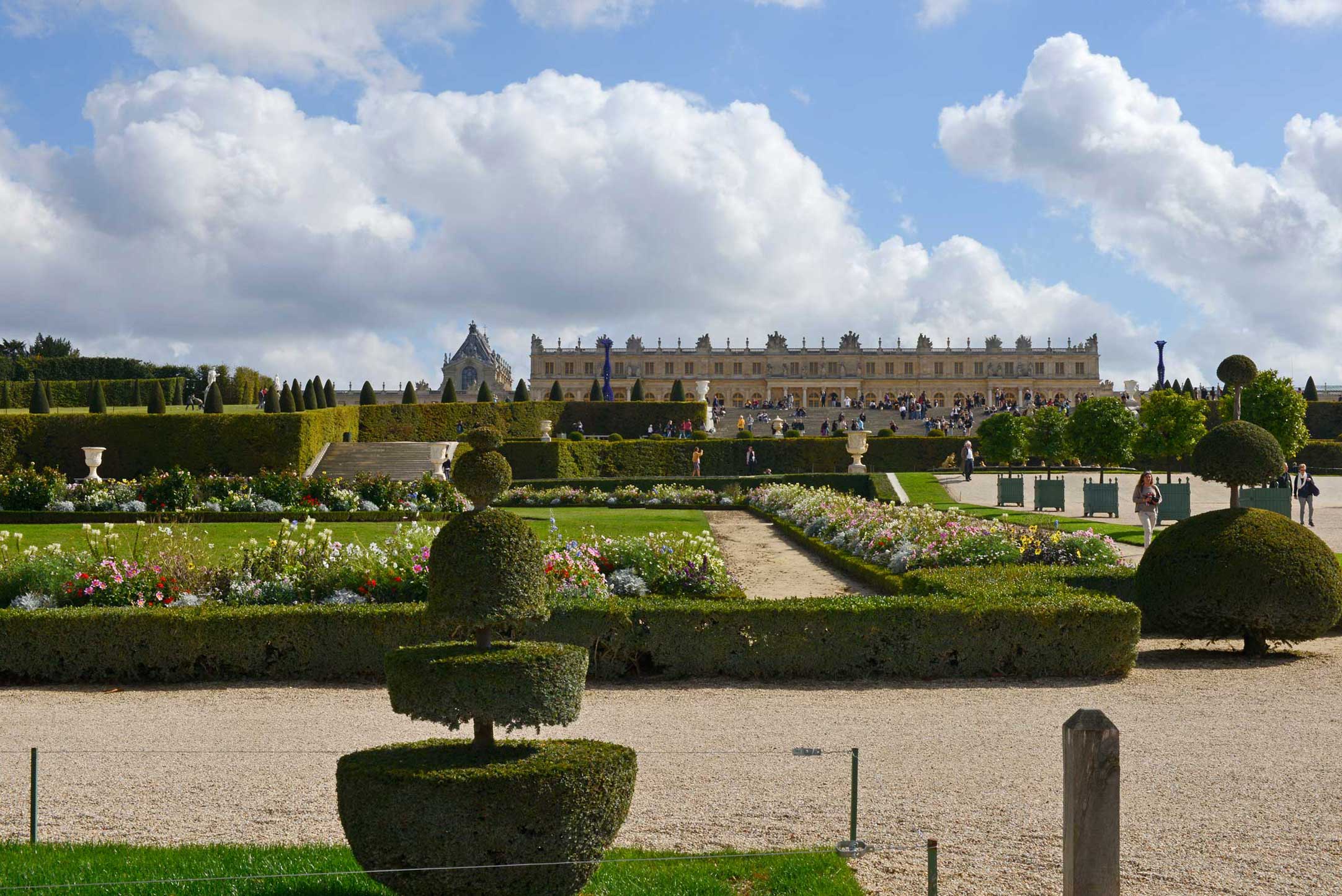


-WEB")


